| |
Temperatures |
Precipitation |
| Site |
Max |
Min |
Avg |
Norm |
Dep |
Hi |
Lo |
Sum |
Norm |
Dep |
| Fayetteville (NW AR) |
53.5 |
29.9 |
41.7 |
36.4 |
+5.3 |
76 |
19 |
3.40 |
2.75 |
+0.65 |
| Harrison (NC AR) |
51.2 |
32.2 |
41.7 |
37.0 |
+4.7 |
75 |
18 |
2.39 |
2.67 |
-0.28 |
| Jonesboro (NE AR) |
52.6 |
37.4 |
45.0 |
38.7 |
+6.3 |
70 |
22 |
5.41 |
3.52 |
+1.89 |
| Fort Smith (WC AR) |
56.2 |
34.5 |
45.3 |
40.4 |
+4.9 |
77 |
25 |
1.93 |
2.91 |
-0.98 |
| Little Rock (C AR) |
58.6 |
39.6 |
49.1 |
40.7 |
+8.4 |
77 |
25 |
8.16 |
3.50 |
+4.66 |
| Texarkana (SW AR) |
63.4 |
43.9 |
53.6 |
44.6 |
+9.0 |
82 |
30 |
4.28 |
3.64 |
+0.64 |
| El Dorado (SC AR) |
60.4 |
38.8 |
49.6 |
44.7 |
+4.9 |
78 |
23 |
9.79 |
4.39 |
+5.40 |
| Pine Bluff (SE AR) |
59.2 |
41.8 |
50.5 |
42.8 |
+7.7 |
77 |
27 |
9.05 |
3.82 |
+5.23 |
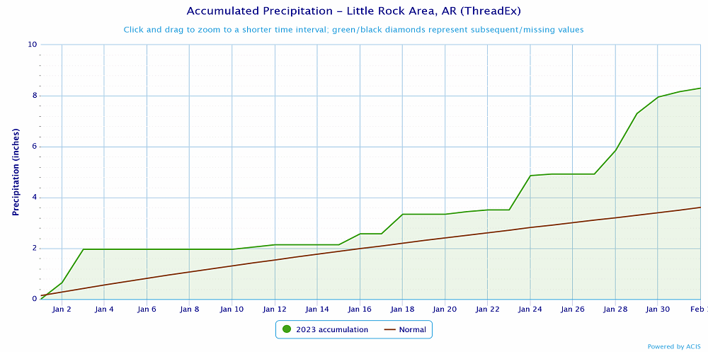
Temperatures across the state were well above normal in January with nearly all of the state experiencing a surplus of rainfall as well.
| |
| Temperature records broken in January. Check out the records below. |
| Site |
Record High (Date of Occurrence) |
| Monticello |
77T (1/11) |
| Little Rock |
77T (1/11) |
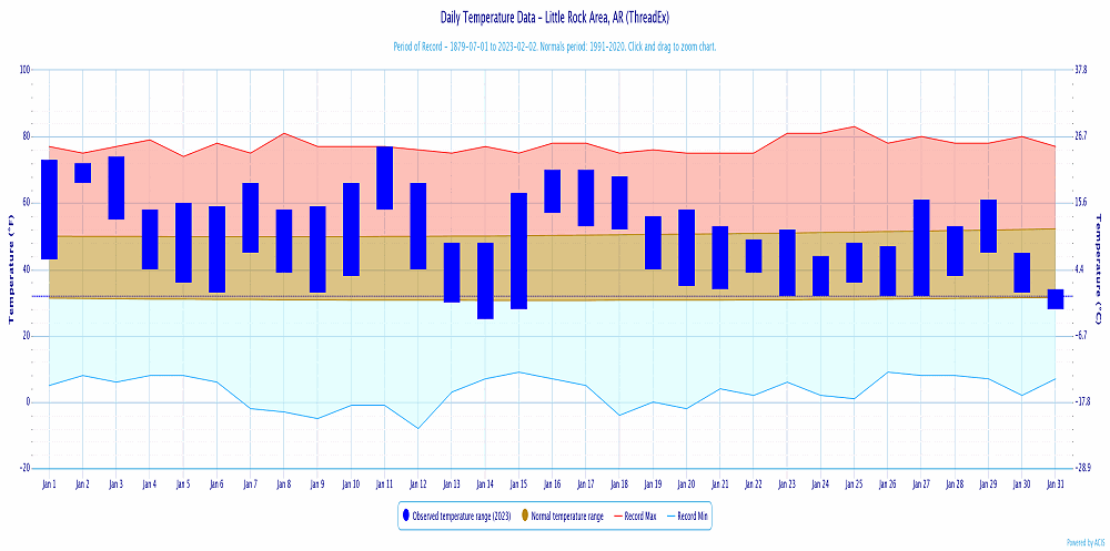
January was a busy weather month across Arkansas with severe thunderstorms, flash flooding and winter weather all occurring. With the exception of the few rounds of winter weather, temperatures through the month were well above normal. Little Rock recorded it's 8th warmest January, records began in 1879.
|
|
| In the picture: A tornado watch was issued for portions of Arkansas and areas to the southwest on January 2nd. |
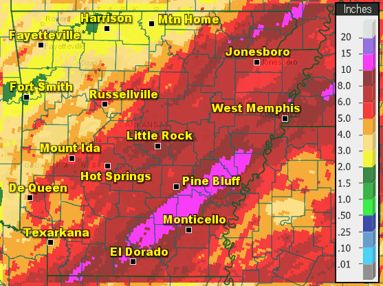
Active weather was quick to start at the beginning of the month, with widespread rain and thunderstorms noted from January 2-3. Four tornadoes occurred along with some wind damage. As thunderstorms persisted through the morning of January 3rd, heavy rain kept adding up. Some locations across east/southeast Arkansas picked up nearly 12" of rainfall leading to widespread flooding issues.
|
|
| In the picture: A radar loop of a severe thunderstorm that produced 2" hail across western Arkansas. |
After rain and storms moved out of the area temperatures returned to near normal for a couple days with fairly quiet weather conditions noted. That didn't last very long as temperatures warmed rapidly through January 10-11. Temperatures approached or exceeded 80° on the 11th with a couple of record highs tied across the state. Warm temperatures provided fuel for an approaching storm system and yet another round of severe thunderstorms developed and moved from western parts of the state northeastward. Some large hail was observed with initial thunderstorms that developed across western Arkansas, but there wasn't much additional severe weather after that.
Behind these storms a strong cold front pushed through which brought falling temperatures and strong winds to the state on January 12th. In the wake of the strong low pressure system some light snow was even observed across far northern Arkansas into southern Missouri. Amounts remained light and the snow didn't last very long.
Cooler, near normal temperatures and dry weather were seen across the state around the middle of the month before high temperatures once again climbed above normal, in the 60s and 70s. Some showers and thunderstorms developed across central and eastern Arkansas on January 16th which provided some locally heavy downpours to the area. Additional storms, including some that became severe developed across the state on the 18th. Most of the severe weather was confined to southern Arkansas, where a couple tornadoes occurred along with some wind damage.Windy conditions and cooler temperatures returned to the state in the wake of a cold front, on January 19th.
|
|
| In the picture: Satellite imagery shows snow cover across the state from the January 24-25 heavy snowfall event. |
After January 18th there wasn't any additional severe weather across the state, but a few rounds of winter weather were in store. The first of which took place from January 24-25. Heavy rain fell across the southeast half of the state while the northwest half of the state experienced sufficent cold air for snow to fall. Higher terrain areas across the Ouachitas and Ozarks received the highest totals, more than 12 inches in spots.
Near the end of the month a cold, shallow Arctic airmass spread south across much of the southern United States. A stationary front was in position south of the state and an upper level storm system was located across the southwest US. A steady stream of moisture lifted northeast across the state toward the Ohio Valley and interacted with the cold air in place at the surface. Precipitation was observed for a few days with mainly sleet falling across northern Arkansas with widespread freezing rain observed across portions of central, eastern and southern Arkansas. Southwest Arkansas remained above freezing throughout the event with little to no winter weather seen there.
| Temperature and Precipitation Trends |
| |
 |
| In the picture: Temperatures at Little Rock (Pulaski County). Click to enlarge. |
|
 |
| In the picture: Precipitation at Little Rock (Pulaski County). Click to enlarge. |
|
 |
| In the picture: Precipitation across Arkansas. |
|
|