| |
Temperatures |
Precipitation |
| Site |
Max |
Min |
Avg |
Norm |
Dep |
Hi |
Lo |
Sum |
Norm |
Dep |
| Fayetteville (NW AR) |
63.2 |
36.0 |
49.6 |
48.4 |
+1.2 |
84 |
13 |
3.59 |
3.98 |
-0.39 |
| Harrison (NC AR) |
61.0 |
38.9 |
49.9 |
49.2 |
+0.7 |
80 |
15 |
4.30 |
3.91 |
+0.39 |
| Jonesboro (NE AR) |
63.5 |
40.5 |
52.0 |
51.1 |
+0.9 |
76 |
22 |
3.88 |
4.73 |
-0.85 |
| Fort Smith (WC AR) |
66.2 |
39.1 |
52.6 |
53.5 |
-0.9 |
80 |
20 |
2.91 |
3.90 |
-0.99 |
| Little Rock (C AR) |
67.7 |
42.7 |
55.2 |
52.7 |
+2.5 |
82 |
26 |
6.29 |
4.96 |
+1.33 |
| Texarkana (SW AR) |
70.5 |
45.5 |
58.0 |
56.0 |
+2.0 |
81 |
28 |
5.11 |
4.45 |
+0.66 |
| El Dorado (SC AR) |
69.3 |
40.3 |
54.8 |
56.3 |
-1.5 |
83 |
23 |
6.15 |
5.10 |
+1.05 |
| Pine Bluff (SE AR) |
67.9 |
43.6 |
55.8 |
54.6 |
+1.2 |
82 |
26 |
6.72 |
5.29 |
+1.43 |
Temperatures were generally above average across the state with a few locations ending up slightly below. Precipitation amounts were generally near or above average statewide. Portions of southern Arkansas received the most widespread rainfall surplus with more than a few locations seeing totals more than one inch above average.
| |
| Temperature records broken in March. Check out the records below. |
| Site |
Record High (Date of Occurrence) |
| Stuttgart |
77T (3/3), 81 (3/6) |
| Batesville |
81 (3/3) |
| North Little Rock |
78T (3/6) |
| Note: "T" means record was tied. |
Similar to February, March proved to be a busy month with not only winter weather noted across the state but a few rounds of severe weather as well. Temperatures weren't significantly above or below average but nearly all reporting stations reached a high of 80° or better. Additionally, lows across northern Arkansas dipped down into the teens during the morning of March 12th after a winter weather event the previous day.
|
|
| In the picture: A "heads up" graphic was shared on March 3rd indicating that chances of severe thunderstorms and heavy rainfall would increase by March 6th to 7th. |
Dry conditions were in place to start the month with temperatures warming to well above average readings. Much of the state experienced temperatures at or above 80° for the first few days of the month. Dry air and well above average temperatures led to increased fire danger, quickly drying out soils after the recent late March rainfall across the state. A new storm system approached the state from March 5th through 6th which would bring major changes to the area.
At the surface, a front was oriented from southwest to northeast across the state which would help focus the severe weather threat across northern Arkansas. As the upper level storm system moved closer to the area, severe storms developed during the afternoon of March 6th through the morning of the 7th. One main supercell thunderstorm travelled from southeast Johnson County to Randolph County and was responsible for multiple tornadoes through the evening of March 6th. Some additional storms produced mainly weak tornadoes that evening into the early morning hours of the 7th.
Colder air moved across the state in the wake of the storm system with some light precipitation noted on Tuesday, March 8th. The precipitation spread from south to north with sleet noted for some along the leading edge. Across the northern third of the state, some light snow was even observed. No accumulation was observed, temperatures were quite cool for early March with readings in the mid 30s to mid 40s.
|
|
| In the picture: A video of a weather balloon launch while snow was falling at the NWS Little Rock office on March 11th. |
After temperatures rebounded into the 50s/60s and sunshine was observed across the area, yet another storm system approached the state. As a cold front moved across the state from late March 10th through the afternoon hours of March 11th, precipitation began to move in behind it. Snow was the primary precipitation type with some areas seeing rain or a brief winter mix initially before changing over to snow. While snow ended across the west and northwest by the afternoon hours on March 11th, snow persisted through the evening hours across the east and southeast. Snowfall totals ranged from less than an inch to nearly 6” in spots. Road conditions deteriorated mainly across the N/NW with just a few slick spots developing elsewhere as well.
Very cold air moved in across the state after the snow came to an end. Northern Arkansas experienced temperatures in the teens during the morning hours on March 12th. Elsewhere, temperatures fell into the 20s. Even after the cold morning temperatures, snow rapidly melted given the warm ground conditions, increasing temperatures and mid-March sun angle.
|
|
| In the picture: Severe weather chances were expected to increase March 21-22, mainly south and east of the state. Heavy rain would be a concern for much of Arkansas and surrounding areas. |
Dry conditions were noted through the morning of the 14th before additional rain developed across the state from the 15th through the 16th. Some locally heavy amounts were observed, some portions of southwest Arkansas measured over two inches of rainfall.
After a brief break in the rain on the 16th, a line of storms moved across the state from late on the 17th into the morning hours of the 18th. The heaviest rain occurred across the south and east with 0.25 to 0.75 inch amounts common. Cooler air was briefly observed in the wake of the front that brought the thunderstorms to the area, but temperatures rebounded quickly ahead of the next storm system. Highs from Mar 19-21 were in the 70s to near 80 degrees. Dry and windy conditions were noted those days as well.
A strong system brought severe weather to east Texas on the 21st with mostly just rain and thunderstorms across Arkansas, although nickel size hail was reported near Murfreesboro (Pike County). While severe weather wasn't widespread locally, very heavy rain was seen across Arkansas. Areas from southwest to northeast Arkansas saw rainfall amounts between 2-3 inches into the 22nd. As the rain was departing to the east on the 22nd, some strong winds developed in its wake. Several locations saw gusts to 40 mph or higher for less than an hour. Severe weather developed once again on the 22nd, but mainly across Louisiana, Mississippi and Alabama. The rain helped improve ongoing drought conditions across southern Arkansas but also worsened ongoing river flooding across the state. Much cooler air was seen for a few days from Mar 22-24. Lows fell into the 30s/40s and highs were mainly in the 50s/60s.
Temperatures began to warm ahead of yet another approaching storm system expected to move across the state late on the 29th through the 30th. Thunderstorms developed across portions of Oklahoma and Texas late on the 29th, continuing into the 30th. Storms made their way into western Arkansas during the early morning hours of the 30th with one storm producing an EF3 tornado in Springdale (Washington County) and another storm producing an EF1 tornado near the Harmony community (Johnson County). Storms formed into a line and moved east across the state through the afternoon hours. Ahead of the line of thunderstorms, strong southerly winds were observed across the state. The highest wind gusts were seen across eastern parts of the state. Severe weather became more widespread to the east of the Mississippi River during the afternoon and evening hours of the 30th. Cooler air moved in behind the line of storms with some snow flurries even occurring across northern Arkansas on the 31st.
| Temperature and Precipitation Trends |
| |
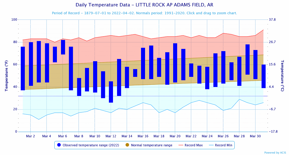 |
| In the picture: Temperatures at Little Rock (Pulaski County). Click to enlarge. |
|
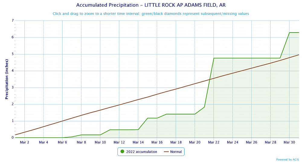 |
| In the picture: Precipitation at Little Rock (Pulaski County). Click to enlarge. |
|
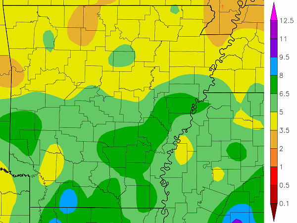 |
| In the picture: Precipitation across Arkansas. |
|
|


 Follow us on YouTube