 |
| Storm Reports |
| Are you interested in what happened during a recent event? Check out the report below. |
|
|
 |
Cooling Down/Spotty Severe Storms/Heavy Rain on August 15-29, 2022 |
 |
| |
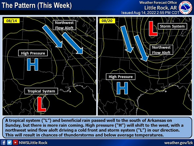 |
| In the picture: High pressure ("H") shifted to the southwest in mid-August, 2022, allowing a storm system ("L") and cold front to approach from the north. This resulted in less heat and chances of showers and thunderstorms. |
|
| |
|
The pattern changed in mid-August. A big ridge of high pressure in the Plains (that was responsible for heat/spotty rain in Arkansas) exited to the west, and a storm system and cold front approached from the north.
|
|
|
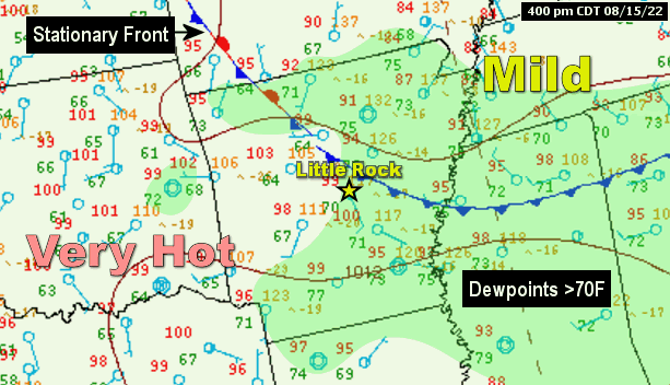
| In the picture: A front was draped across Arkansas on 08/15/2022, and separated very hot air to its southwest from milder conditions farther northeast. Abundant low level moisture (dewpoints in the 70s) pooled around the front, and this helped fuel developing thunderstorms in the afternoon. |
|
| |
|
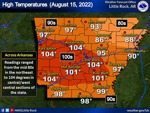
On the 15th, the front made headway through northeast Arkansas, and afternoon temperatures were only in the 80s. It was still hot farther to the southwest, with readings in the 90s to around 104 degrees. It was the hottest day of the year to this point at Little Rock (Pulaski County) as the mercury hit 104 degrees. It was also 104 degrees at De Queen (Sevier County), Fort Smith (Sebastian County), and Russellville (Pope County). The front was surrounded by plenty of moisture in the low levels of the atmosphere, and this fueled scattered afternoon thunderstorms.
|
|
|
| In the video: Scattered strong to severe thunderstorms popped up during the afternoon of 08/15/2022, including this one in Scott County, Arkansas. The video is courtesy of Darby Bybee via Twitter. |
|
| |
|
The storms unleashed strong to damaging winds in places. Between Hot Springs and Royal (both in Garland County), numerous trees were downed. There was some roof damage, as well as damage to a shed and a fence.
|
 |
| High Temperatures (08/15) | High Temperatures (08/17) |
| In the pictures: It was very hot on 08/15/2022, with temperatures in the mid 90s to around 104 degrees in much of Arkansas (and 80s in the northeast). A couple of days later, readings were in the 70s and 80s. |
|
| |
|
Behind the front, it was a different world by the 17th. High temperatures were only in the 70s and 80s. The front wobbled around in or near the region the next few days before a new cold front pushed through from the north on the 21st/22nd. By this time, moisture levels were through the roof as remnants of a tropical system in south Texas came into play. A heavy rain event was in the works as the front and moisture collided.
|
|
|
| In the picture: A funnel cloud was picked up by an Arkansas Department of Transportation traffic camera (right side of photo) near Jennette (Crittenden County) on 08/22/2022. The information was made available by the National Weather Service in Memphis, TN via Twitter. |
|
| |
|
Tropical moisture led to pop up showers and several funnel clouds in eastern Arkansas on the 22nd. A funnel may have actually touched the ground briefly (making it a tornado) near Jennette (Crittenden County).
|
|
|
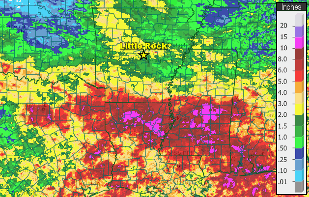
| In the picture: Fourteen day rainfall through 700 am CDT on 08/25/2022. Amounts topped ten inches in places from northeast Texas to northern Louisiana, southern Mississippi, southwest Alabama, and the Florida panhandle. |
|
| |
|
Once the heavy rain kicked in (along the aforementioned front that crossed Arkansas on the 21st/22nd), there was a lot of it (more than ten inches in places) from northeast Texas all the way to the Florida panhandle. Crossett (Ashley County), El Dorado (Union County), and Magnolia (Columbia County) picked up more than four inches of precipitation.
|
|
|
| In the video: Way too much rain and flash flooding led to high water rescues at Brandon, MS on 08/24/2022. The video is courtesy of Charles Peek via Twitter. |
|
| |
|
Life threatening flash flooding was noted late on the 21st/22nd in Dallas, TX and surrounding areas. Late on the 23rd and into the 24th, it was the same scenario in Jackson, MS.
|
| Way Too Much Water |
|
Torrential rain fell in Dallas/Fort Worth, TX on August 21st/22nd. A whopping 9.19 inches of liquid was measured, which was the second most twenty four hour amount on record locally (not far behind the 9.57 inch total on September 4th/5th, 1932). Even with an ongoing extreme drought (and sixty seven days with no measurable rain from June 4th through August 9th), there was a lot of flooding. Intersections became lakes, cars were submerged, and water flowed into homes/businesses. Three to four hundred people were rescued. A woman was killed when her vehicle was swept away by fast moving current.
On the 23rd/24th, it happened again in Mississippi. A two day total of 8.58 inches of rain at Jackson, MS wreaked havoc, and sent the Pearl River toward a Top 15 record crest. It was the wettest August day on record on the 24th, with 5.05 inches of precipitation tallied. In nearby Canton, MS, people were on top of their cars to escape rising water. Dozens of children were rescued at a day care center at Florence, MS. Water overwhelmed a nursing home in Brandon, MS, and at least three dozen residents were taken to safety. Northeast of Conehatta, MS, a portion of Highway 489 was completely washed away. Due to complications from an overflowing Pearl River (and other long term issues), the water system failed in Jackson, MS, and officials scrambled to provide water for 180,000 people.
|
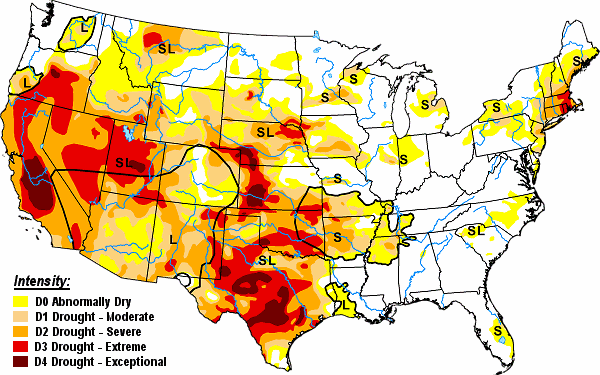 |
| In the picture: Drought conditions were widespread in the western and central United States, parts of the Great Lakes, and New England on 08/23/2022. |
|
| |
|
There was not enough rain in Arkansas to end a drought that became widespread in July. On the 23rd, the worst drought conditions (D2/D3 intensity) affected the central, west central, and northwest counties.
|
|
|
| In the picture: A Flash Flood Warning was posted in Benton County during the late afternoon/early evening of 08/29/2022. The warning was issued and shared via Twitter by the National Weather Service in Tulsa, OK. |
|
| |
|
On the 29th, one more cold front headed this way from Missouri. Showers and thunderstorms ahead of the front dumped one to more than two inches of rain in about the northern two rows of counties in Arkansas. Lead Hill (Boone County) and Mammoth Spring (Fulton County) had more than two inches, as did portions of Benton County. At Bentonville (Benton County), an 11-year-old boy was swept into a storm drain, as was a 47-year-old woman who tried to save him. They were pulled from the drain and taken to a nearby hospital. They both passed away.
|
|
|


 Follow us on YouTube