Are you interested in what happened during a recent event? Check out the report below.
Heavy Rain on February 7-8, 2023
In the picture: A storm system ("L") approached from southeast Oklahoma on 02/08/2023. Ahead of the system, a front was nearly stationary across central Arkansas. Heavy rain was expected north of the front, with a chance of severe weather farther south.
Heavy to excessive rain was in the forecast on February 7th/8th, especially in northern and western Arkansas. This was ahead of a storm system in the southern Plains, and north of a nearly stationary front draped across central sections of the state. South of the front, increasing warmth/moisture set the stage for the possibility of severe thunderstorms toward evening on the 8th.
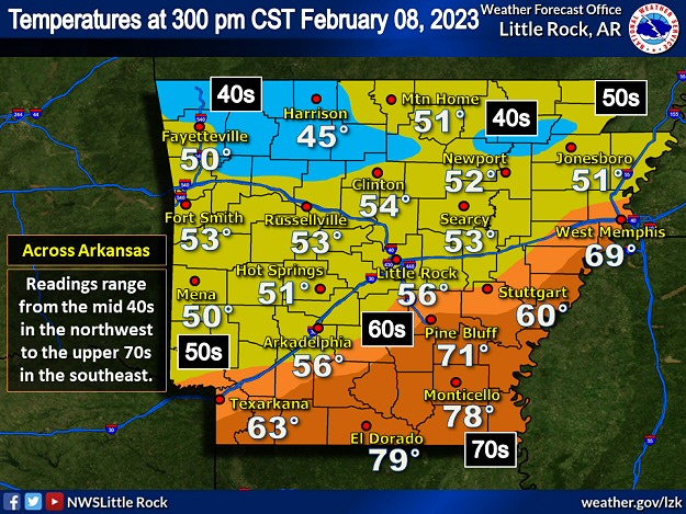
In the picture: Temperatures varied widely across Arkansas at 300 pm CST on 02/08/2023. Readings were only in the 40s/50s where widespread rain was occurring (northern/western sections of the state), with 60s/70s farther south where it was mostly dry.
The placement of the front was obvious as of 300 pm CST on the 8th. North of the front, temperatures were only in the 40s/50s. The thermometer showed 45 degrees at Harrison (Boone County), 46 degrees at Rogers (Benton County), and 49 degrees at Walnut Ridge (Lawrence County). Readings were in the 60s/70s farther south, with a springlike 78 degrees at Monticello (Drew County), and 79 degrees at Camden (Ouachita County) and El Dorado (Union County).
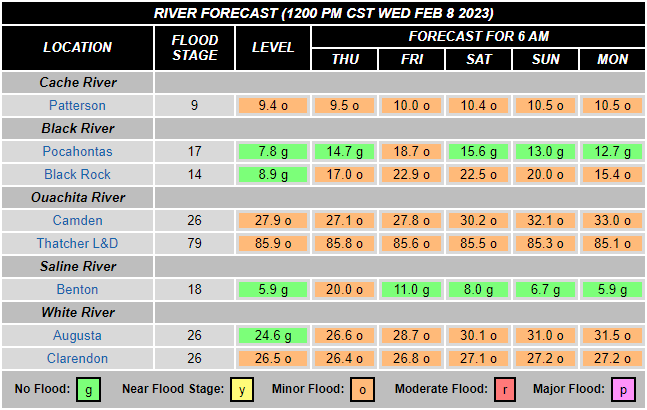
In the picture: Minor flooding was expected or already occurring along the Black, Cache, Ouachita, Saline, and lower White Rivers at 1200 pm CST on 02/08/2023.
As this event unfolded, area tributaries were already elevated. Minor flooding was occurring along rivers mainly in southern and eastern Arkansas.
In the video: This is a satellite loop from midnight to 400 pm CST on 02/08/2023. Much of the loop shows widespread clouds/rain in northern and western Arkansas. Toward the end of the loop (during the afternoon), rain in the north/west became more scattered, and thunderstorms developed farther south.
Rain got going in the north/west after dark on the 7th and continued on the 8th. The heaviest downpours were generally to the north of Texarkana (Miller County), Little Rock (Pulaski County), and Blytheville (Mississippi County).
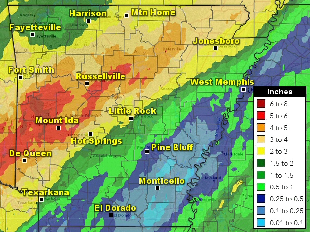
In the picture: Forty eight hour rainfall through 600 am CST on 02/09/2023.
Three to more than six inches of precipitation dumped at many locations in the north/west. Forty eight hour amounts through 600 am CST on the 9th included 6.60 inches at Mountain View (Stone County), 6.03 inches at Big Fork (Polk County), 5.82 inches at Mena (Polk County), 5.66 inches at Hattieville (Conway County), 5.42 inches at Witts Springs (Searcy County), 5.32 inches at Vandervoort (Polk County), 5.30 inches at Langley (Pike County), 5.24 inches at Damascus (Van Buren County), 5.19 inches at Morrilton (Conway County), 5.18 inches at Danville (Yell County), 5.12 inches at Murfreesboro (Pike County), 5.09 inches at Cushman (Independence County), 5.03 inches at Greers Ferry Dam (Cleburne County), and 5.02 inches at Mount Ida (Montgomery County).
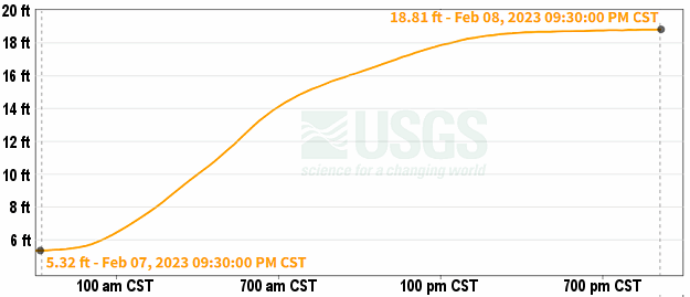
In the picture: Heavy to excessive rain caused the Poteau River at Cauthron (Scott County) to climb more than thirteen feet on 02/08/2023.
So much rain caused rivers to jump in the north/west, with minor to moderate flooding experienced or expected along the Fourche LaFave, Little Missouri, Little Red, Petit Jean, Spring, and upper White Rivers. Existing problems along the Black, Cache, Ouachita, Saline, and lower White Rivers (in the south/east) got a little worse. The Poteau River at Cauthron (Scott County) rose more than thirteen feet. Where the river meets Jones Creek about four miles to the northwest of Waldron (Scott County), there was enough water to close Highway 80.
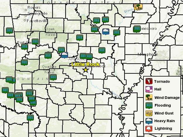
In the picture: There were isolated severe weather reports and numerous flash flood reports in northern and western Arkansas on 02/08/2023.
A few creeks were out of their banks in Howard County, and flooded nearby roads. Bear Creek overflowed, and covered Brady Mountain Road northwest of Royal (Garland County). Highway 307 near Belleville (Yell County) was submerged, and people in a vehicle stuck in high water needed to be rescued north of town. Near Worthen (Pope County), there was a mudslide along Highway 363. Water flowed into homes not far from Hamlet (Faulkner County). Roads were turned into lakes and were impassible near Clinton (Van Buren County). It was the same story in portions of Izard and Sharp Counties, as well as in the Jonesboro (Craighead County) area. Close to Saint James (Stone County), roads were washed out.
As evening approached on the 8th, rain in the north/west became less widespread, and thunderstorms popped up farther south/east. There was only one report of severe weather in Arkansas. Just west of Corning (Clay County), utility poles were toppled and a portable storage building was damaged. There were more severe storms and mainly wind damage (trees and power lines downed/minor structural damage) in southern Illinois, western Kentucky, and southeast Missouri. A strong tornado (rated EF2) ripped apart multiple mobile homes and tore up the roof of a church at Tangipahoa, LA. No injuries were noted. Otherwise, isolated weak tornadoes (rated EF0/EF1) were spawned in parts of Louisiana and Mississippi.


 Follow us on YouTube