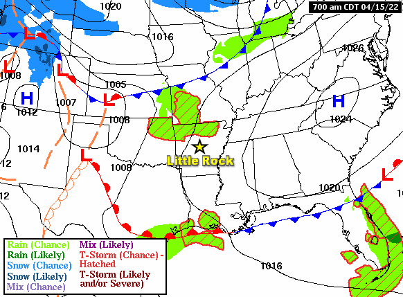
In the pictures: Forecast maps on 04/15/2022 showed a large area of fair weather high pressure ("H") exiting to the east of Arkansas, and a warm front lifting to the north into the state from the Gulf Coast. Warm, moist, and unstable air followed the front. As this was happening, a cold front approached from the north, and scattered strong to severe thunderstorms developed in northern and western sections of the state during the evening and overnight hours.
Two days after an onslaught of severe storms in Arkansas, we were at it again on April 15th. The cold front that moved through on the 13th (bringing cooler air/a temporary end to active weather) was headed back into the state from the Gulf Coast. The front was the focus for a massive storm toward the Missouri border in the evening.
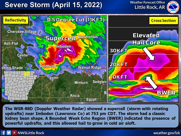
In the picture: The WSR-88D (Doppler Weather Radar) showed a supercell (storm with rotating updrafts) near Imboden (Lawrence County) at 753 pm CDT on 04/15/2022. The storm had a classic kidney bean shape. A Bounded Weak Echo Region (BWER) indicated the presence of powerful updrafts, and this allowed hail to grow in cold air aloft.
Between 700 pm and 1000 pm CDT, the storm tracked east/southeast along the front through Baxter, Fulton, Sharp, Lawrence, Greene, Craighead, and Mississippi Counties. Along the way, the storm unleashed huge hail that damaged structures and vehicles.
Hail was softball size or larger at Cherokee Village (Sharp County), Lake City (Craighead County), and five miles west of Viola (Fulton County). Baseball size hail was noted at Caraway (Craighead County) and southeast of Walcott (Greene County).
How Rare is Huge Hail?
With the exception of 2005 and 2013, baseball size or larger hail was observed in Arkansas at least once a year since 1980 (through 2021). Hail at least softball size occurred once every other year (21 of 42 years). As far as numbers of reports, of the roughly 5,859 instances of quarter size or larger hail, 2,475 were at least golf balls (42.2% of reports), 256 were at least baseballs (4.4% of reports), and 50 were at least softballs (0.9% of reports). The largest hailstones were five inches in diameter (slightly larger than a DVD) on January 21, 1999; April 2, 2006; and May 4, 2020.
The radar detected strong rotation in the storm, and there were indications the storm may be tornadic. Several Tornado Warnings were issued, and Tornado Emergencies were declared given damage reports and sightings of funnels reaching the ground. However, it appears most of the damage was caused by hail, and there were no confirmations of tornadoes during a damage survey.
What About the Tornado Emergencies?
On April 11th and 15th (twice in less than a week), Tornado Emergencies were declared by the National Weather Service in Little Rock. Tornado Emergencies are usually reserved for rare situations when: (1) a severe threat to human life is imminent or ongoing, (2) catastrophic damage is imminent or ongoing, and (3) a tornado is confirmed visually and/or by radar.
While (3) applied in both cases, (1) and (2) were based on reports of destruction of property. It was assumed the destruction was caused by tornadoes, when it was actually wind driven large hail (baseball size or bigger). Even if it was clear that hail was the culprit, Tornado Warnings (versus Severe Thunderstorm Warnings) would have certainly been issued (given strong rotation). Also, it appears some reports of tornado sightings were erroneous, and this added to the confusion.
It must be mentioned that sometimes it is difficult to know exactly what is happening, especially in rural settings when reports are spaced apart or non-existent. Time of day is also a factor, with details hidden by darkness at night. During the Stone/Izard County Tornado of April 14, 1996, there were no reports of significant damage until the event was over. It took awhile to find out an F4 monster tracked forty miles, and killed seven people (the deadliest tornado nationwide that year). If this had occurred today, and the rules were followed, there would probably not be a Tornado Emergency (because of a lack of ground truth).
The moral of the story is forecasters in warning mode are trained to do the best they can with information they have to protect life and property. The goal is to make sure people are not caught off guard, and have time to find shelter. Keeping folks safe is the name of the game. The mission was accomplished on April 11th and 15th...tornadoes or not.
In the video: The WSR-88D (Doppler Weather Radar) showed scattered strong to severe thunderstorms developing across western Arkansas between 300 am and 630 am CDT on 04/16/2022.
Early on the 16th, a new cold front approached from the northwest, and triggered more storms across the western counties. Just after 400 am CDT, tennis ball size hail pelted the Springdale (Washington County) area.
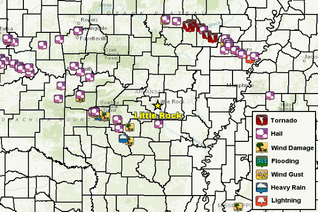
In the picture: Severe weather reports on April 15-16, 2022.
Elsewhere before 700 am CDT, trees and powerlines were downed at Waldron (Scott County), and two to three inches of rain was measured. A barn was damaged, a tree was blown onto a house, and there was golf ball size hail at Oden (Montgomery County). More trees were toppled at Mount Ida (Montgomery County), and the west side of town lost power. Rain came down in buckets, with 1.59 inches of precipitation in only 23 minutes! A tree fell on a car at Silver (Montgomery County), and quarter size hail was reported at Bismarck (Hot Spring County) and Caulksville (Logan County).
Storm Reports
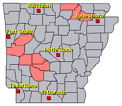
There was very large hail in parts of the north and west on April 15th/16th, and several reports of wind damage, tornadoes, and heavy rain. For a look at the reports, click here.


 Follow us on YouTube