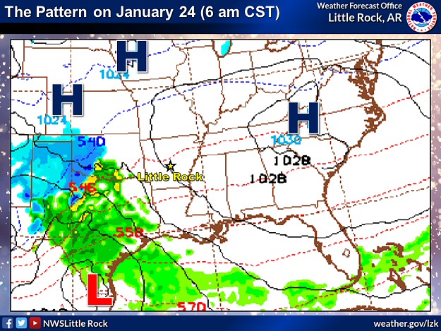
In the pictures: This forecast model showed a storm system ("L") tracking from southern Texas to western Kentucky in the twenty four hour period ending at 600 am CST on 01/25/2023. The system spread snow across northern and western Arkansas, and triggered severe thunderstorms along the Gulf Coast.
Following a blast of Arctic air on December 22nd (2022), winter was largely absent in Arkansas through the first three weeks of January. In fact, severe weather was more of a concern, with tornadoes spawned on the 2nd and 18th (in central/southern sections of the state). There were signs the pattern would change on the 24th/25th, and it would get cold enough to support heavy snow in the north and west.
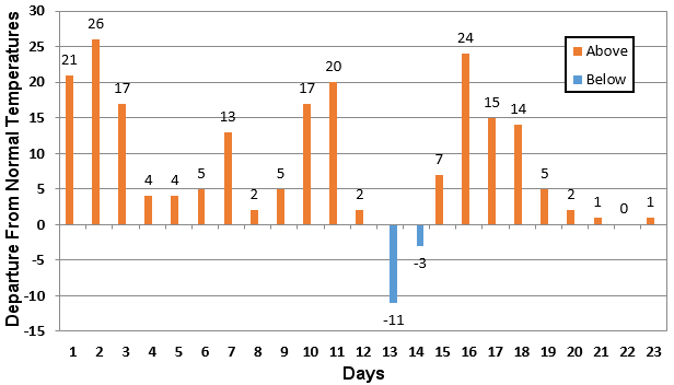
In the picture: Prior to the snow, temperatures in January, 2023 (through the 23rd) were largely above to well above average at Harrison (Boone County).
Snow was not mentioned much at all through the first twenty three days of January. Temperatures at most locations across the region were eight to twelve degrees above average. Forecast models changed the conversation, with some models indicating more than a foot of snow in portions of northern Arkansas leading up to the event.
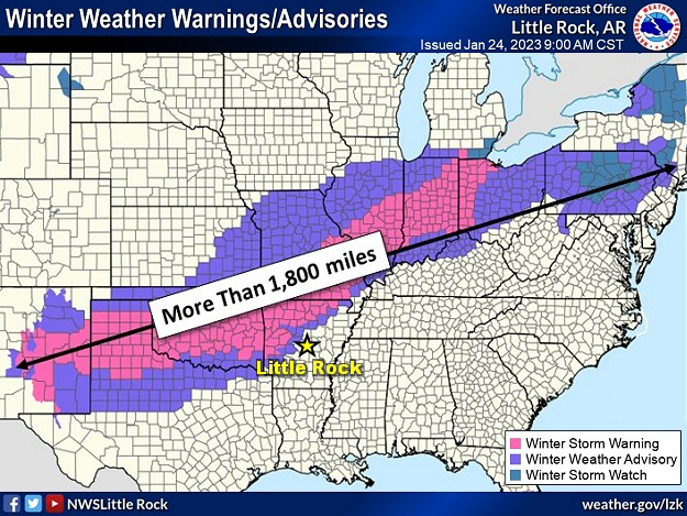
In the picture: Winter headlines were posted from the southern Rockies to the western Great Lakes (more than 1,800 miles) at 900 am CST on 01/24/2023.
As confidence in a big snow episode increased, Winter Storm Warnings were posted in the Ozark and Ouachita Mountains. Snow was expected to begin by the early afternoon of the 24th.
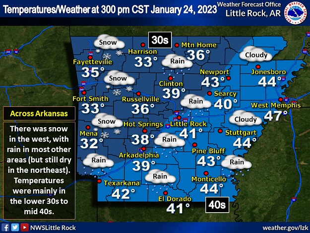
In the picture: Snow was falling in western Arkansas, with rain in most other parts of the state at 300 pm CST on 01/24/2023. Temperatures were mainly in the lower 30s to mid 40s.
By 300 pm CST, snowflakes were flying from Mena (Polk County) and Mount Ida (Montgomery County) to Fayetteville (Washington County) and Harrison (Boone County). Temperatures in these spots were in the lower to mid 30s. Farther south/east, it was too warm for snow, with rain occurring at most reporting stations.
In the video: Snow covered Highway 71 near Y City (Scott County) at 230 pm CST on 01/24/2023. The video is courtesy of the Arkansas Department of Transportation.
The first noticeable problems on roads were in the Ouachita Mountains (Polk and Scott Counties). While a warm ground prevented much accumulation initially, snow came down fast enough to pile up on the pavement and cause accidents.
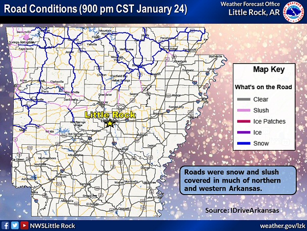
In the picture: Roads were snow and slush covered across northern and western Arkansas at 900 pm CST on 01/24/2023. The information is courtesy of IDriveArkansas.
As the afternoon and evening progressed, many roads north and west of Little Rock (Pulaski County) were snow/slush covered and hazardous.
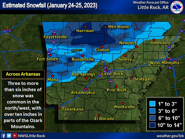
In the picture: Three to more than six inch snow accumulations were common in northern and western Arkansas on January 24-25, 2023. Parts of the Ozark Mountains received over ten inches of snow.
By the morning of the 25th, Mount Magazine (Logan County) had 16 inches of snow, with 14.5 inches southeast of Kay (Searcy County), 13 inches southeast of Jasper (Newton County) and at Witts Springs (Searcy County), 12.5 inches at Compton (Newton County), 12 inches at Bruno (Marion County) and Chimes (Van Buren County), 11.5 inches at Deer (Newton County) and Leslie (Searcy County), and 11 inches at Batson (Johnson County), Big Flat (Baxter County), Diamond City (Boone County), Dodd City (Marion County), and Pindall (Searcy County).
In the video: Heavy wet snow caused branches to sag or break onto power lines, and this created power outages in Fayetteville (Washington County) on 01/25/2023. The video is courtesy of Charles Peek via Twitter.
Elsewhere, three to more than six inch totals were common across much of northern and western Arkansas. Across the southern/central/eastern counties, while there were sleet pellets and snowflakes in places, rain was the main precipitation type. One to two inches of liquid was widespread.
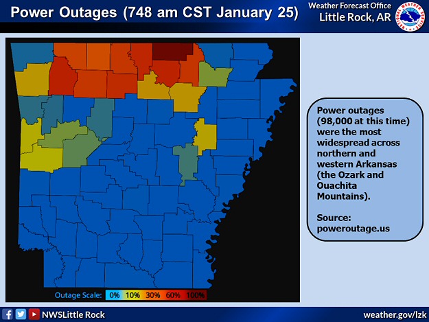
In the picture: Almost 100,000 utility customers were without power as of 748 am CST on 01/25/2023. The information is courtesy of PowerOutage.us.
Due to the heavy wet snow in the north/west, many tree limbs/power lines were downed. At one point, there were over 100,000 power outages.
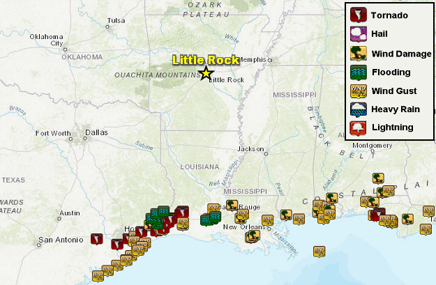
In the picture: Severe weather and flash flooding were confined to locations along the Gulf Coast in the twenty four hour period ending at 800 am CST on 01/25/2023.
It was much more mild toward the Gulf Coast, and this is where severe storms developed from eastern Texas to the Florida panhandle. A tornado (rated EF3) caused extensive structural damage on the southeast side of Houston, TX (at Deer Park, TX and Pasadena, TX). Vehicles and semi trucks were flipped by a tornado (rated EF2) along Interstate 10 near Orange, TX. Roofs were removed from homes by a tornado (rated EF2) from southeast of DeQuincy, LA to Gaytine, LA. A tornado was confirmed on radar (by a debris signature) at Grayton Beach FL.
From Drought to Deluge in California
Leading up to our heavy snow event, there was a massive deluge in California. Worries about long term drought conditions were put on hold, at least temporarily. From December 26th (2022) through January 17th (2023), a statewide average 11.47 inches of precipitation dumped. This was just over half (51%) of what the state should receive in an average year (22.39 inches)! There were several reports of three to four feet of rain, and fifteen or more feet of snow in the highest elevations of the Sierra Nevada Mountains. At San Francisco, CA (at the airport), 15.28 inches of rain fell, which was the highest twenty three day total on record locally. So much precipitation in a short time led to overflowing tributaries, flooding of homes and businesses and roads, mudslides, and sinkholes. At least twenty two fatalities were blamed on this extreme high water episode. For more information (graphically), click here.


 Follow us on YouTube