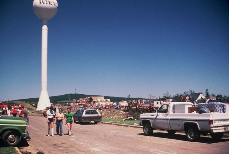
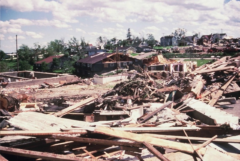
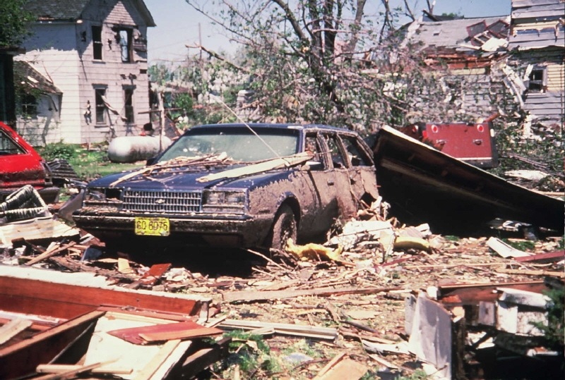
June 8, 1984 Barneveld, WI F5 Tornado
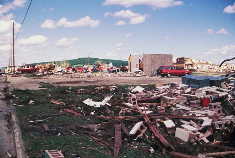
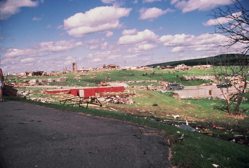
Early in the morning hours of June 8, 1984, a series of tornadoes affected portions of Southern Wisconsin. A number of these tornadoes were strong to violent, causing significant damage. The most notable tornado was the one that struck the town of Barneveld, Wisconsin in Iowa County shortly before 1 AM. About 90 percent of the town of Barneveld was destroyed. 93 homes were destroyed, and 64 were damaged. Seventeen of eighteen businesses and public buildings in the village were destroyed. This tornado was rated a F5 on the Fujita Scale for tornado intensity. A F5 is the highest rating that a tornado can achieve, and this particular tornado was given a F5 rating because of the severity of the damage caused to relatively new construction homes in Barneveld. More information about this tornado, and other tornadoes in the outbreak, is available below.
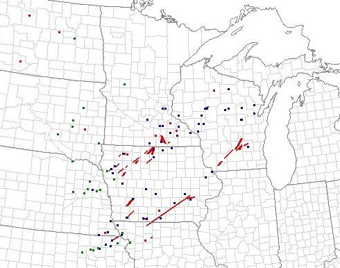
The severe weather outbreak spanned 8 states including the Eastern Dakotas, Eastern Nebraska, Northeast Kansas, Northwest Missouri, Iowa, Southern Minnesota and Wisconsin. The most significant severe weather occurred from Iowa, northeastward into Southern Minnesota and Southern Wisconsin. This was also the same area that experienced the most tornadoes and the most persistent and severe thunderstorm activity through the late afternoon and evening of June 7th.
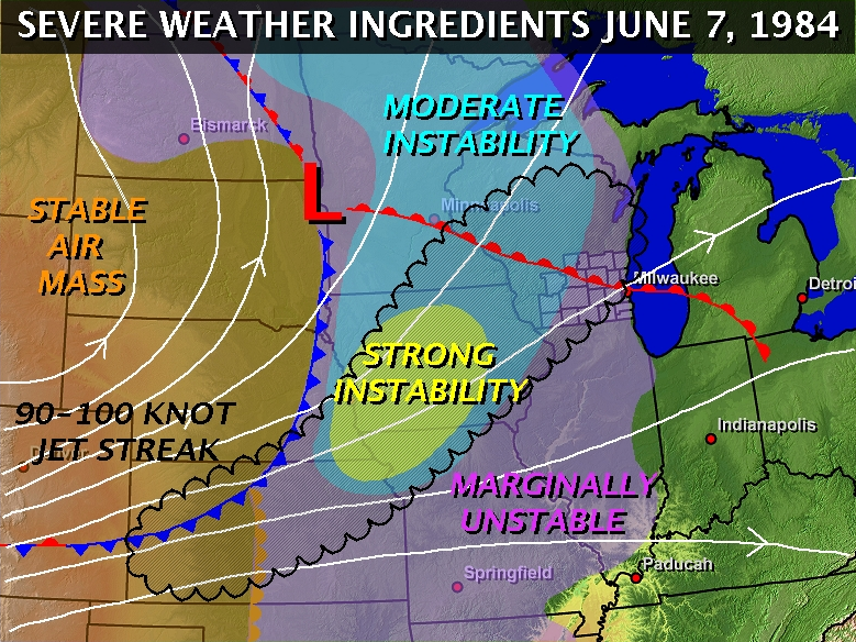
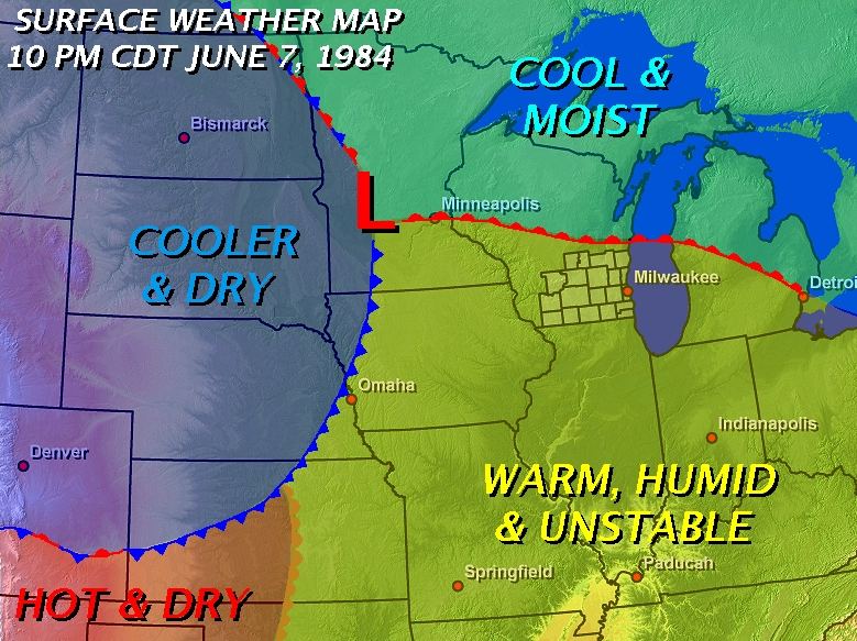
The two maps above show the general weather setup back on June 7-8, 1984. The image on the left is a composite image with several severe weather ingredients overlaid. It depicts the conditions around 7 PM on June 7, 1984, but please note that some smoothing and estimation was used in the production of that graphic. Shaded in purple, blue, and yellow are the varying levels of instability ahead of the low pressure system, based on the actual observed lifted indices. You can see that the axis of best instability encompassed most of Iowa, Southeastern Minnesota and Western Wisconsin at 7 PM. The white lines are upper level streamlines, showing the direction of the wind flow in the upper levels of the atmosphere. Finally, the black shaded and scalloped area is the approximate location of a very strong upper level jet streak.
Vertical wind shear, the difference in wind speeds, and wind direction, between the upper levels of the atmosphere and the lower levels of the atmosphere, was maximized underneath the strong jet streak. The tornado outbreak occurred about where the strongest wind shear and most unstable air mass overlapped.
The image on the right shows the basic surface front locations at about 10 PM on June 7, 1984, or about 3 hours prior to the "Barneveld tornado". The storms, at that time, were progressing across Northwest and West-Central Wisconsin, and stretched back through Eastern Iowa and into Northern Missouri. This means that the storms were moving across a very warm, humid, and unstable air mass as they approached Wisconsin. With abundant energy, and strong vertical wind shear, the storms continued to produce severe weather well after dark.
|
|
||||
|
|
|
|
|
|
|
|
|
|
|
|
|
|
|
|
|
|
|
|
|
|
|
|
|
|
|
|
|
|
|
|
|
|
|
|
|
|
|
|
|
|
|
|
|
|
|
|
Belmont Area F2 Tornado
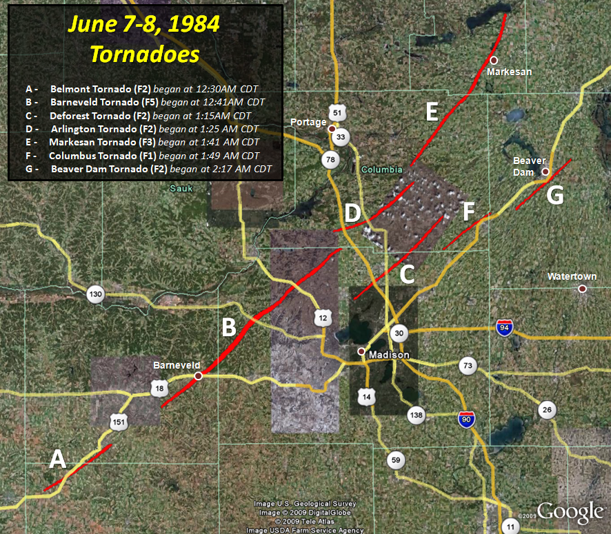
The tornadoes in Southern Wisconsin were produced by a cluster of supercell thunderstorms that moved northeast through the area shortly after midnight on June 8, 1984. The first tornado that occurred began just south of Belmont in Lafayette County at about 12:30 AM CDT. Mostly tree damage was noted along the path of the tornado, with some trees uprooted, but some structural damage also occurred. A barn and several outbuildings were destroyed, and a house was unroofed. The tornado moved into Iowa County and dissipated near Mineral Point.
Barneveld F5 Tornado
The second tornado was the strongest of the entire outbreak in the Midwest. This tornado began about 5 to 6 miles southwest of Barneveld at 12:41 AM CDT, and widened and intensified as it approached the town. The Barneveld area was hit shortly before 1:00 AM CDT, and the tornado moved into Dane County quickly thereafter. It struck the Black Earth area around 1:07 AM CDT, but did not dissipate until around 1:40 AM CDT in far northern Dane County. As mentioned, about 90 percent of the Village of Barneveld was destroyed. A significant amount of damage occurred along most of the path, but the most severe damage was in the Village of Barneveld. Some fairly new homes were completely destroyed with only the foundation remaining. Some 25 million dollars worth of damage occurred in Barneveld alone. 9 people were killed, and another 200 were injured. The total path length was about 36 miles and the tornado was on the ground for 59 minutes.

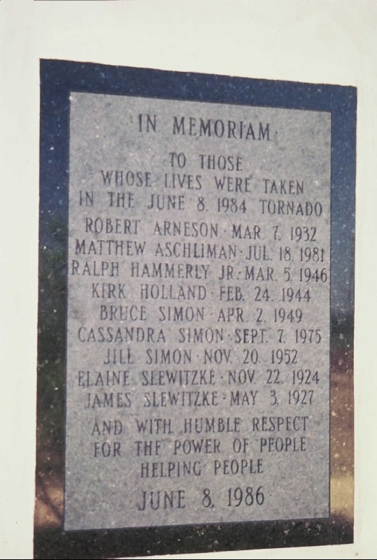
To this date, the "Barneveld Tornado" remains the second costliest tornado, based on official damage costs, in Wisconsin history with total damage estimated at $40 million. The "Oakfield Tornado" on July 18, 1996 remains the costliest tornado in state history, with total estimated damage costs at $40.4 million. However, if you adjust for inflation to 2009 dollars, the Barneveld tornado becomes the costliest tornado in Wisconsin history. As mentioned, a F5 rating is the highest rating that a tornado could achieve on the Fujita Scale. Only three tornadoes in Wisconsin have attained such a rating since 1950 - the Oakfield tornado, the Barneveld tornado, and another that occurred on June 4, 1958 striking the town of Colfax, Wisconsin.
|
|
||||
|
|
|
|
|
|
|
|
|
|
|
|
|
|
|
|
|
|
|
|
|
|
|
|
|
|
|
|
|
|
|
|
|
|
|
|
|
|
|
|
|
|
|
|
|
|
|
|
|
|
|
|
|
|
|
|
|
|
|
|
|
|
|
|
|
|
Deforest Area F2 Tornado
A tornado began at about 1:15 AM CDT, right around Deforest, while the Barneveld Tornado was still in progress further to the west in Dane County. Several houses were unroofed in the Deforest area. The tornado continued northeast into Columbia County. The total track length was approximately 21 miles.
Arlington Area F2 Tornado
A tornado began at about 1:25 AM CDT, right around Arlington, also while the Barneveld Tornado was still in progress off to the southwest. There was some damage to some barns, garages and sheds as the tornado moved northeast for about 16 miles before dissipating in central Columbia County.
Markesan F3 Tornado
The fifth tornado in Southern Wisconsin during this outbreak began at about 1:41 AM CDT. It started near Rio in Columbia County, and moved northeast into Green Lake County with time. A farm near Cambria suffered significant damage to most of the buildings on the property. This tornado likely had the second longest track of the tornadoes that occurred in Southern Wisconsin, close to 30 miles.
Columbus Area F1 Tornado
A tornado began at about 1:49 AM CDT to the west-southwest of Columbus and then moved northeast to near the Columbia-Dodge County border in the vicinity of Columbus. The tornado was on the ground for about 10 miles.
Beaver Dam Area F2 Tornado
The last tornado to occur during the outbreak in Southern Wisconsin began at about 2:17 AM CDT. It started off to the southwest of Beaver Dam in western Dodge County, and then moved northeast, barely missing the city of Beaver Dam to the southeast. The tornado eventually dissipated to the northeast of Beaver Dam in rural northern Dodge County. Fairly extensive damage was noted on a handful of homes, along with some farm outbuildings being destroyed.
ORIGINAL PUBLIC INFORMATION STATEMENT ABOUT THE TORNADOES
AN AREA OF LOW PRESSURE GATHERED STRENGTH ACROSS THE UPPER MIDWEST DURING
THE AFTERNOON OF JUNE 7 1984. MOISTURE...SHEAR...AND INSTABILITY HELPED TO
SPAWN TORNADOES OF THE F1 TO F3 VARIETY ACROSS NORTHERN MISSOURI...
NORTHEASTERN KANSAS...SOUTHERN AND NORTHWESTERN IOWA...AND
SOUTHEASTERN MINNESOTA.

AS THE ATMOSPHERE BECAME MORE UNSTABLE BY THE LATE EVENING HOURS...A
CLUSTER OF THUNDERSTORMS DEVELOPED OVER SOUTHWESTERN WISCONSIN. THE
FIRST TORNADO WAS NOTED TO SPIN UP IN THE BELMONT AREA AT 1230 AM CDT
JUNE 8. THIS TORNADO TRAVELED TO MINERAL POINT WHERE IT DISSIPATED.
THIS TORNADO WAS RECORDED AS AN F2 ON THE FUJITA SCALE.

AT 1241 AM CDT A SECOND TORNADO SPUN UP SOUTH OF RIDGEWAY AND
INTENSIFIED RAPIDLY AS IT CRASHED THROUGH BARNEVELD IN IOWA COUNTY.
THE VIOLENT TORNADO CONTINUED HEADING NORTHEAST INTO BLACK EARTH BY
107 AM CDT. THE TORNADO FINALLY DISSIPATED AT 140 AM CDT JUST
SOUTHEAST OF LODI...NEAR THE COLUMBIA/DANE COUNTY BORDER.

AFTER A 36 MILE LONG PATH FOR 59 MINUTES...93 HOMES WERE COMPLETELY
DESTROYED...64 OTHERS WERE DAMAGED. SEVENTEEN OF THE EIGHTEEN BUSINESSES
AND PUBLIC FACILITIES IN THE TOWN OF BARNEVELD WERE ALSO DESTROYED.
NEARLY 90 PERCENT OF THE TOWN WAS COMPLETELY DEVASTATED. AT ONE POINT
IN TIME...THE WIDTH OF THE TORNADO DAMAGE WAS NEARLY 400 YARDS WIDE.

DESPITE THE TORNADO PROPAGATING THROUGH THE TOWN IN THE MIDDLE OF THE
NIGHT...IN COMBINATION WITH THE MYTH CIRCULATING AROUND THE TOWN THAT NO
TORNADOES COULD EVER SURVIVE THE HIKE UP THE BLUE MOUND...9 PEOPLE DIED
AND 197 OTHERS WERE INJURED. 25 MILLION DOLLARS IN DAMAGE WAS CALCULATED.
IT WAS LATER DETERMINED BY TED FUJITA THAT THE BARNEVELD TORNADO WAS
INDEED AN F5...THE HIGHEST LEVEL ON THE FUJITA TORNADO SCALE.

THE CLUSTER OF THUNDERSTORMS THAT SPAWNED THE BARNEVELD TORNADO HAD ALSO
SPAWNED OTHER TORNADOES ACROSS SOUTHERN WISCONSIN LATER THAT NIGHT. OTHER
TORNADOES INCLUDED...

...THE F2 ARLINGTON /COLUMBIA CO./ TORNADO...
...THE F2 DEFOREST /DANE CO./ TORNADO...
...THE F3 MARKESAN /GREEN LAKE CO./ TORNADO...
...THE F1 COLUMBUS /DODGE CO./ TORNADO...
...THE F2 BEAVER DAM /DODGE CO./ TORNADO...

ALL IN ALL...9 PEOPLE WERE KILLED AND 200 OTHERS WERE INJURED DURING THE
ENTIRE TORNADO OUTBREAK. TOTAL DAMAGE WAS CALCULATED AT 40 MILLION...25
OF THAT 40 MILLION OCCURRED IN BARNEVELD ALONE.

...A COMPREHENSIVE SUMMARY OF THE FUJITA SCALE...

...WIND SPEEDS ARE ESTIMATED FROM DAMAGE SURVEYS...

F1...40-72 MPH
F2...73-112 MPH
F3...113-157 MPH
F4...207-260 MPH
F5...261-318 MPH


 Follow us on YouTube