National Weather Service United States Department of Commerce

Thunderstorms Across the Southeast U.S.; Elevated to Locally Critical Fire Weather in Colorado

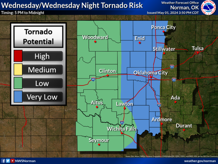
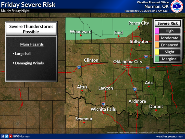
A few strong to marginally severe thunderstorms are possible across the Southeast U.S. Friday. A Marginal Risk (Level 1 of 5) outlook has been issued. Strong winds and hail will be the main threats. Elevated to locally critical fire weather conditions will persist across south-central Colorado today due to dry conditions and gusty winds. Read More >

Click a location below for detailed forecast.

Last Map Update: Fri, Apr. 19, 2024 at 3:36:12 am CDT

National Weather Service Dodge City, KSNational Weather Service Wichita, KansasNational Weather Service Tulsa, OK
National Weather Service Amarillo, TXZoom
Out

National Weather Service Tulsa, OK
National Weather Service Lubbock, TXNational Weather Service Fort Worth/Dallas, TXNational Weather Service Shreveport, LA

Shower and thunderstorm chances will begin this evening along the Red River. Chances will spread north and increase overnight. Severe storms are unlikely.
Rain/storm chances are more widespread on Saturday. Severe storms are not expected. Most of the storms will be seen south of I-40, where storm total rainfall amounts could reach 1 to 2 inches by Sunday morning.

 Current Weather Observations...
Location Time
(CDT)
Weather Vsby.
(SM)
Temp.
(ºF)
Dewpt.
(ºF)
Hum.
(%)
Wind
(mph)
Wind Chill / Heat Index
(ºF)
Pres.
(in)
Oklahoma City, OK02:52Mostly Cloudy10504171NNE 20G3043 [WC]30.15
Norman, OK02:55Overcast10524167N 20G28-30.14
Stillwater, OK19:53Overcast10574667N 18G26-30.09
Lawton, OK02:53Clear10534163NNE 20G30-30.12
Wichita Falls, TX02:52Overcast10564771NNE 17G24-30.11
Ponca City, OK02:53Clear10434192N 937 [WC]30.21
Enid, OK02:55Clear10443981NNE 839 [WC]30.18
Alva, OK03:15Clear10463052NNE 1340 [WC]30.22
Woodward, OK02:50Clear10422856NNE 936 [WC]30.26
Gage, OK02:53Clear10452748NE 1239 [WC]30.23
Watonga, OK02:55Clear10434190N 937 [WC]30.23
Clinton, OK02:53Clear10444292N 939 [WC]30.20
Weatherford, OK03:15Clear10464285NNE 1040 [WC]30.19
Hobart, OK02:53Clear10484382NNE 1542 [WC]30.18
Altus, OK03:15Clear10504276NNE 1744 [WC]30.18
Frederick, OK02:53Mostly Cloudy10544264NE 13-30.12
Ardmore, OK03:15Overcast10554876N 12-30.09
Ada, OK03:15Overcast10554876NNE 16G23-30.11

Local Weather History For April 19th...
Late afternoon and evening severe weather, in the form of hail to the
size of softballs and at least 5 tornadoes, affected southeast
Oklahoma on this day in 2011. Stringtown, in Atoka county, received
hail the size of softballs, while numerous tornadoes moved through
the Kiamichi Mountains of far southeast Oklahoma. Thankfully, there
were no reports of injuries.

Text Product Selector (Selected product opens in current window)
Weather Observations Area Forecast Discussion Air Quality Forecasts Hydrology Information Frequently Asked Questions Social Media
Observations Discussion Air Quality Hydrology FAQ Social Media
 
Submit a Storm Report Graphical Weather Forecasts Aviation Weather Forecasts Climate Data Storm Data Weather Radio Information
Storm Reports Gridded Forecast Aviation Climate Storm Data Weather Radio  
 
Satellite Information Hourly Weather Forecast Fire Weather Information Past Weather Events StormReady Skywarn/Storm Spotters
Satellite Hourly Forecast Fire Weather Past Events StormReady Storm Spotters