NOAA/NWS 1925 Tri-State Tornado Web Site--1925: Now vs. Then
Have you ever wondered how various National Weather Service severe weather products may have looked if today's weather warning system had existed back in 1925? Well if you have, the information on this page will attempt to give you an idea of how today's meteorologists might have forecasted the 1925 Tri-State Tornado from the vantage points of both the Storm Prediction Center and the local Weather Forecast Offices. Keep in mind that the products shown on this page are only hypothetical examples.
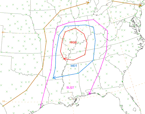
Early in the morning of March 18, 1925, the Storm Prediction Center (SPC) in Norman, Oklahoma would have issued a Day 1 Outlook, which is a risk assessment of the potential for severe thunderstorms and tornadoes valid for a 24-hour period from the morning of March 18 through the morning of March 19. Shown below is the hypothetical Day 1 Outlook, which depicts a high risk for severe weather over portions of Missouri, Illinois, Indiana, Kentucky, and Tennessee.
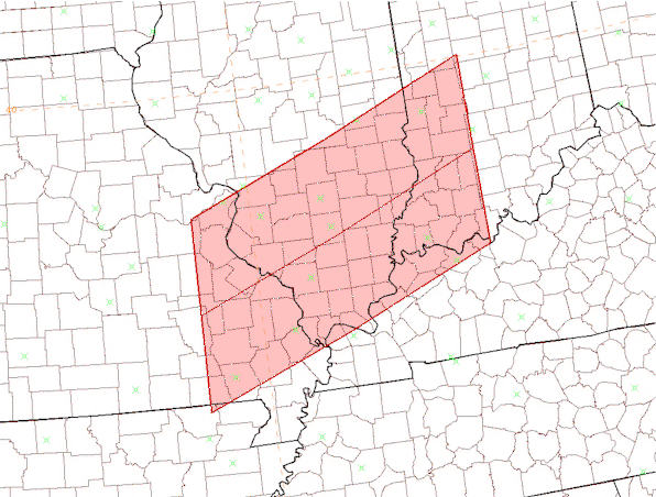
As the morning progressed, SPC would have closely monitored the Lower Ohio and Middle Mississippi River Valley Region for the potential issuance of a Tornado or Severe Thunderstorm Watch. Around the noon hour, SPC likely would have issued a Tornado Watch for portions of Missouri, Illinois, Indiana, and Kentucky. This hypothetical watch box is depicted below.
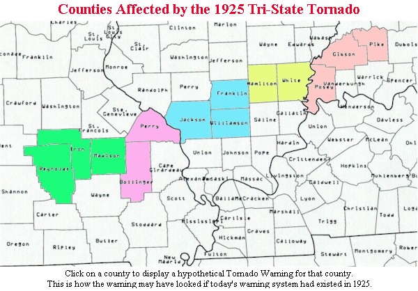
After the issuance of the Tornado Watch, the local Weather Forecast Offices (WFO's) would have been responsible for issuing Tornado, Severe Thunderstorm, and/or Flash Flood Warnings based on information gleaned from radar and satellite images, current observations, computer model data, and storm spotters. With the enormous size of the Tri-State Tornado, it is likely that all warnings issued on that particular storm would have been Tornado Warnings. Because the storm moved at speeds of 60 to 70 mph over much of its path, the Tornado Warnings probably would have included more than one county--a technique known as "blanket" warning. To view the hypothetical warnings that might have been issued by the WFO's in St. Louis, Missouri, and Paducah, Kentucky, click on the shaded counties in the map below.
While the information contained on this page is only hypothetical, it clearly demonstrates how much the watch/warning system has advanced since 1925. Because of the advanced technology and communications system in place today, it is highly unlikely that nearly 700 lives would be taken, even by a storm of this magnitude. Keep in mind, however, that even today's warning system does little good if the public fails to heed the warning's message to take shelter.
The author of this page would like to acknowledge Dan McCarthy of the Storm Prediction Center for providing the hypothetical Day 1 Outlook and Tornado Watch maps. Also, thanks to Jim Packett at WFO Paducah for creating the hypothetical Tornado Warnings.
Tornado Track | Weather Ingredients | First-Hand Accounts | Startling Statistics | Photographs
Interesting Quotes | 1925: Now vs. Then | General Information | Links/Resources | Contact Us


 Follow us on YouTube