Strong to severe thunderstorms and heavy rain will impact portions of the central Plains into the Upper Midwest and the Mid-Atlantic through the weekend. A stretch of unusually hot and humid weather is expected across portions of the central U.S. and the Southeast beginning this weekend and continuing through next week. The heat may reach dangerous levels, particularly mid to late next week. Read More >
|
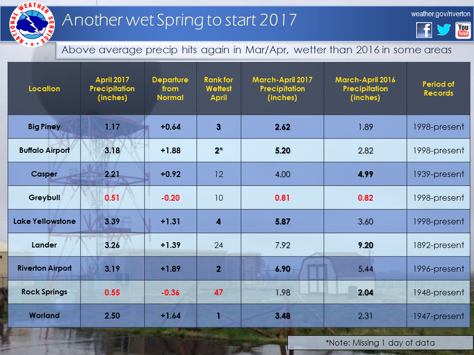
The April 2017 climate summaries for Big Piney, Buffalo, Casper, Greybull, Lake Yellowstone, Lander, Riverton, Rock Springs, and Worland are now available online. April 2017 started out with fairly normal temperatures, however in the middle of the month the temperatures warmed significantly, into the mid 70s to low 80s. This lasted from the 12th to around the 18th before temperatures returned to normal. The month was a wet and snowy one. A major storm on the 8th dropped up to 2 inches of rain and up to 20 inches of snow across the state. A late Spring storm at the end of April dropped more widespread snow across the State. The higher elevations received over two feet of snow, with 3-10 inches elsewhere. See the links below for details for individual sites or click here for Water Year Precipitation summaries for more locations. If you would like additional/more in-depth climate information, please refer to our Climate Page. Under the Observed Weather tab, you can find the Daily Climate Report (CLI), the Preliminary Monthly Climate Data (CF6), the Monthly Weather Summary (CLM), and the Regional Summary (RTP/STP). The Daily Climate Report will have the weather data for the day (from midnight to 1159 pm). The Monthly Climate Data will have this data for each day of the month, compiling all the daily data into one form. The Regional and State Summaries will have temperature and precipitation data for various locations across the state, updated 4 times a day.
|
|