There was a moderate to severe drought from western into central Arkansas on 07/10/2018.
In the picture: There was a moderate to severe drought from western into central Arkansas on 07/10/2018.
 

By the late spring, a switch was thrown. It warmed up quickly in May, and the rain shut off. Above average temperatures continued through June and July, and rainfall remained subpar. Drought conditions developed from southwest into central sections of the state.


Record Warm May/June/Julys in Arkansas
Year Avg Temp +/-
2018 78.9° +3.7°
1882 78.9° +3.7°
1956 78.4° +3.2°
1939 78.4° +3.2°
1884 78.3° +3.1°


Hail was not as big as a softball (shown), but it was at least baseball size five miles southwest of Hector (Pope County) on 06/02/2018. The photo is courtesy of Amanda Duvall.
In the picture: Hail was not as big as a softball (shown), but it was at least baseball size five miles southwest of Hector (Pope County) on 06/02/2018. The photo is courtesy of Amanda Duvall. Click to enlarge.
Mammatus clouds (noted when it is turbulent/stormy) were spectacular in parts of northern Arkansas on 06/02/2018. The photo is courtesy of Mel Coleman.
In the picture: Mammatus clouds (noted when it is turbulent/stormy) were spectacular in parts of northern Arkansas on 06/02/2018. The photo is courtesy of Mel Coleman. Click to enlarge.
 

While rain was generally hit and miss, there were massive thunderstorms at times. On June 2nd, storms produced huge hail in western Arkansas. Hail bigger than baseballs pelted areas between Dover and Hector (both in Pope County). Hen egg size hail was measured at Mountain Valley (Garland County), with golf ball size hail just southwest of Harrison (Boone County).


Mostly hail was reported in western Arkansas on 06/02/2018, with wind damage common across the eastern counties.
In the picture: Mostly hail was reported in western Arkansas on 06/02/2018, with wind damage common across the eastern counties.
 

Farther east, extreme winds tore through the Delta. An airport was destroyed (yes, destroyed) at Colt (St. Francis County). Two large grain bins were dismantled south of Fisher (Poinsett County), with one grain bin tossed 75 feet. Lots of trees were uprooted or splintered west of Waldenburg (Poinsett County), a shed was mangled, and the roof of a shop was removed. A dozen power poles were snapped in a row along Highway 64 west of Wynne (Cross County). Numerous trees were on houses in Forrest City (St. Francis County), and two semi-trailers were overturned.


Heat index values ranged from 100 degrees to 120 degrees across Arkansas at 400 pm CDT on 07/20/2018.
In the picture: Heat index values ranged from 100 degrees to 120 degrees across Arkansas at 400 pm CDT on 07/20/2018.
 

There was a lot of severe weather on July 20th/21st. It was also very hot. The mercury soared to 108 degrees at Fort Smith (Sebastian County), 107 degrees at De Queen (Sevier County, and 106 degrees at Hot Springs (Garland County) and Mount Ida (Montgomery County). Humidity levels made it feel even worse. Maximum heat index values across the state ranged from 100 degrees to a staggering 120 degrees.

Given all of the heat, the atmosphere became increasingly unstable. Data collected from a balloon flight at 400 pm CDT revealed a tremendous amount of energy ready to be released. Once that happened, storms took off in a hurry!

During the evening of the 20th, storms were prevalent from central into southeast Arkansas. Between 900 and 1100 pm CDT, tree and power line damage in Clarendon (Monroe County) resulted in a loss of power to the whole town. Trees were also pushed over at Ulm (Prairie County), with one tree on a vehicle. South of Casscoe (Arkansas County), a metal outbuilding was destroyed. Numerous trees fell along Highway 17 near Ethel (Arkansas County). There was quarter to half dollar size hail at Gibson and Jacksonville (both in Pulaski County). Quarters also pelted the National Weather Service in North Little Rock (Pulaski County).


A Very Unstable Atmosphere
Sounding at North Little Rock (Pulaski County) at 700 pm CDT on 07/20/2018

The sounding (temperature and dewpoint profile with height) at North Little Rock (Pulaski County) showed surface CAPE values over 5600 joules/kilogram and an LI of -12 at 700 pm CDT on 07/20/2018! CAPE (Convective Available Potential Energy) is an indicator of instability, and is a measure of energy available for thunderstorm development. It is related to the strength of storm updrafts and the potential for severe weather. Like CAPE, the LI (Lifted Index) is used to determine instability. When the index is negative (unstable), air parcels lifted to 500 millibars (mb) are warmer than the surrounding environment and continue ascending to create storms.


In the video: From midnight to 330 am CDT on 07/21/2018, severe weather was extreme from northwest into central Arkansas. A hailstorm (producing up to baseball size hail) tracked from Fayetteville (Washington County) to Clarksville (Johnson County), and eventually weakened. From there, wind producing (bowing) storms took over, and moved along the Arkansas River from Russellville (Pope County) to Little Rock (Pulaski County).
 

During the predawn hours of July 21st, the focus shifted to the Ozark Mountains of the north. One storm unloaded baseball size hail at Elkins (Washington County) and Crosses (Madison County). Not far to the east, there was a lot of wind with storms at the Buffalo Point Campground near Mull (Marion County). Four people were injured as fallen trees hit recreational vehicles.


In the next few hours, storms worked slowly southward. From there, they picked up speed (40 to 50 mph) and bowed out along the Arkansas River. This bowing line of storms unleashed 70 to 90 mph wind gusts at times.

At Russellville (Pope County), signs were tossed around and windows were blown out around 220 am CST. The doors of a department store were pushed in, and roofs had shingle damage. Ten minutes later, power poles were snapped in half at Atkins (Pope County). A tractor shed in Houston (Perry County) was demolished, and the top of a garage was removed shortly before 300 am CDT. A horse was also killed by lightning. Trees were all over the place in west Little Rock (Pulaski County) by 330 am CDT, with trees blocking roads and on homes. The trees caused damage to roofs and chimneys. By the time it was all over, there were more than 60,000 power outages.

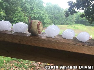
As winds were whipping up along the Arkansas River, there was one other huge storm to note near Hickory Plains (Prairie County). The storm roughed up grain bins and dropped at least golf ball size hail.


Links of Interest
Damage Survey Information (Little Rock County Warning Area)