Across Arkansas, drought conditions were worsening in July, 2018. Three months later, excessive rain made fields muddy and harvesting was difficult to impossible.
In the picture: Across Arkansas, drought conditions were worsening in July, 2018. Three months later, excessive rain made fields muddy and harvesting was difficult to impossible.
 

From August through October, rain was more than double the average at Fort Smith (Sebastian County), Jonesboro (Craighead County), Little Rock (Pulaski County), and Pine Bluff (Jefferson County). At these locations (in west central, central, and northeast Arkansas), there was a surplus of liquid by over ten inches. So much rain made harvesting difficult to impossible in eastern sections of the state given muddy fields.


Precipitation from August 1 - October 31, 2018
Site Amount Normal +/- % of Normal
Fayetteville (NW AR) 11.48 12.39 -0.91 93%
Harrison (NC AR) 12.69 11.33 +1.36 112%
Jonesboro (NE AR) 21.93 9.86 +12.07 222%
Fort Smith (WC AR) 21.98 10.96 +11.02 201%
Little Rock (C AR) 21.82 10.68 +11.14 204%
West Memphis (EC AR) 13.07 10.11 +2.96 129%
Texarkana (SW AR) 12.97 11.27 +1.70 115%
El Dorado (SC AR) 12.10 11.41 +0.69 106%
Pine Bluff (SE AR) 24.85 10.17 +14.68 244%


A ridge of high pressure ("H") was anchored from the southwest United States to the Gulf Coast on 08/14/2018. A storm system ("L") went around the ridge, and brought heavy rain to parts of Arkansas.
In the picture: A ridge of high pressure ("H") was anchored from the southwest United States to the Gulf Coast on 08/14/2018. A storm system ("L") went around the ridge, and brought heavy rain to parts of Arkansas.
 

The wet pattern began in early August. Summer heat and a lack of rain are usually blamed on a persistent ridge of high pressure. During the month, the high camped out along the Gulf Coast, and also in the Rockies and points west. Storm systems went around the high to the north/east, and triggered widespread downpours. By the 10th, Murfreesboro (Pike County) already had record August rainfall (9.50 inches). A staggering 10.63 inches of precipitation was measured near Roland (Pulaski County) in a day (by the morning of the 8th).

In one week (from 700 am CDT on the 13th through 700 am CDT on the 20th), over half a foot of precipitation was common in the north/west from Fort Smith (Sebastian County) to Clarksville (Johnson County) and Clinton (Van Buren County). There were similar amounts in the northeast from Corning (Clay County) to Blytheville (Mississippi County).


Notable Twenty Four Hour Rainfall (Ending at 700 am CDT)
Site Amount Which Day
Blytheville (Mississippi Co) 6.71 08/17
Long Pool (Pope Co) 5.29 08/20
Clinton (Van Buren Co) 4.93 08/20
Paragould (Greene Co) 3.97 08/16
Big Fork (Polk Co) 3.68 08/14
Pine Ridge (Montgomery Co) 3.65 08/14
Ozark (Franklin Co) 3.60 08/14
Bogg Springs (Polk Co) 3.50 08/14
Clarksville (Johnson Co) 3.50 08/20
Fort Smith (Sebastian Co) 3.45 08/16
Booneville (Logan Co) 3.42 08/14
Pine Bluff (Jefferson Co) 3.41 08/20
Damascus (Van Buren Co) 3.25 08/17
Coal Hill (Johnson Co) 3.22 08/20
Little Rock (Pulaski Co) 3.13 08/18


Record August rainfall was measured at several locations in northern and southwestern Arkansas by 08/20/2018.
In the picture: Record August rainfall was measured at several locations in northern and southwestern Arkansas by 08/20/2018.
 

When the downpours finally stopped, at least five August precipitation records were set. This included Blue Mountain Dam (Yell County), Clarksville 6 NE (Johnson County), Clinton (Van Buren County), Greenbrier (Faulkner County), and Long Pool (Pope County). Some records were shattered by several inches. Too much rain led to crop losses in Mississippi County.


Links of Interest
Photo Near Burdette (Mississippi County) of Soybean Field Under Water (courtesy of Jeremy Ross, University of Arkansas System Division of Agriculture)


The satellite clearly showed the remnants of Tropical Storm Gordon approaching Arkansas from the southeast at 1000 am CDT on 09/05/2018.
In the picture: The satellite clearly showed the remnants of Tropical Storm Gordon approaching Arkansas from the southeast at 1000 am CDT on 09/05/2018.
 

in early September, Tropical Storm Gordon exited the Gulf of Mexico to make landfall about 30 miles east of Biloxi, MS on the 4th. By the time the system wobbled into Arkansas late on the 5th/early on the 6th, rain focused over the central and eastern counties.


In the video: There was a lot of standing water in Pine Bluff (Jefferson County) following excessive rain on 09/08/2018 and early the next morning. The images are courtesy of Austin Kellerman via Twitter.
 

The main target for Gordon (and a cold front that entered Arkansas from the north) was the Pine Bluff (Jefferson County) area. From the 6th through the 9th, the local water plant got over 10 inches of rain. This caused a lot of high water issues. Roads and buildings were affected, and numerous vehicles were stranded.


The WSR-88D (Doppler Weather Radar) showed rain and isolated thunderstorms confined to northern and western Arkansas during the morning of afternoon of 10/31/2018. Precipitation finally spread across the remainder of the state during the nighttime hours.
Radar at 700 am CDT (10/31)  |  Radar at 1000 am CDT (10/31)
Radar at 100 pm CDT (10/31)  |  Radar at 400 pm CDT (10/31)
Radar at 700 pm CDT (10/31)  |  Radar at 1000 pm CDT (10/31)
Loop
In the pictures: The WSR-88D (Doppler Weather Radar) showed rain and isolated thunderstorms confined to northern and western Arkansas during the morning of afternoon of 10/31/2018. Precipitation finally spread across the remainder of the state during the nighttime hours.
 

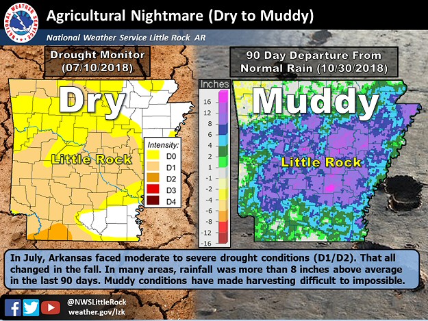
In October, umbrellas were needed the most on Halloween (the 31st). Through much of the day, rain was confined to northern and western Arkansas. Several inches of liquid was reported. Precipitation finally shifted toward the rest of the state after dark.

Mount Ida (Montgomery County) got 5.78 inches of rain on the 31st. This was the most precipitation for any day in October at the site. In the twenty four hour period ending at 700 am CDT on November 1st, Batesville (Independence County) got 5.15 inches, with 4.62 inches at Conway (Faulkner County), 4.50 inches at Alicia (Lawrence County), 4.31 inches at Alum Fork (Saline County), and 4.24 inches at Greers Ferry Dam (Cleburne County). Three to four inches of rain dumped at Murfreesboro (Pike County), Newport (Jackson County), Big Fork (Polk County), Corning (Clay County), Damascus (Van Buren County), Pocahontas (Randolph County), Paragould (Greene County), Mountain View (Stone County), Malvern (Hot Springs County), and North Little Rock (Pulaski County).