Tropical Storm Barry (downgraded from a minimal hurricane) was in southwest Louisiana during the afternoon of 07/13/2019. The system was expected to track through western Arkansas, and produce heavy to excessive rain in the days to follow.
In the picture: Tropical Storm Barry (downgraded from a minimal hurricane) was in southwest Louisiana during the afternoon of 07/13/2019. The system was expected to track through western Arkansas, and produce heavy to excessive rain in the days to follow.
 

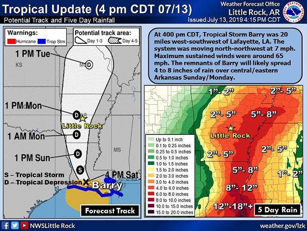
In July, minimal Hurricane Barry (75 mph sustained winds) hit the Louisiana Coast on the 13th. This was bad news for a lot of farmers in Arkansas that were trying to get crops going after a very wet spring and overflowing rivers. The remnants of Barry promised to bring another deluge to the region, and threatened to flood fields and wipe out underdeveloped plants.

The forecast called for the system to head through western sections of the state, with heavy rain east of the track. More than half a foot of precipitation was expected across the central and eastern counties.


In the video: The WSR-88D (Doppler Weather Radar) showed widespread rain over the eastern half of Arkansas on 07/14/2018.
 

While it certainly rained, it did not come down in buckets. Rain was generally light to moderate, and spread out over a couple of days. Overall, it did not measure up to the hype, with many areas receiving two to five inch amounts.


In the video: The WSR-88D (Doppler Weather Radar) showed thunderstorms with torrential downpours developing over the same areas (mainly southwest Arkansas) from 500 am to 900 am CDT on 07/16/2019.
 

While it appeared we dodged a bullet, Barry had one last card to play. As the system exited into southern Missouri, there were signs that the sky would open in parts of southern Arkansas during the wee hours of the 16th. In fact, some data indicated more than ten inches of rain in a small portion of the southwest. It turned out the data was correct. The radar lit up in the southwest late on the 15th, and continued well into the next morning. Rainfall rates exceeded three inches per hour at times.


Twenty four hour rainfall through 700 pm CDT on 07/16/2019. Parts of southwest Arkansas received more than a foot of precipitation.
In the picture: Twenty four hour rainfall through 700 pm CDT on 07/16/2019. Parts of southwest Arkansas received more than a foot of precipitation.
 

Six inches to more than a foot of liquid was estimated by radar in sections of Clark, Hempstead, Howard, Nevada, and Pike Counties. Flash Flood Emergencies were issued by the National Weather Service in these areas. Near Murfreesboro (Pike County), 13.50 inches of rain was reported. Since the 14th, the site had 14.58 inches, which was temporarily a state record for precipitation tied to a tropical system (since 1950).


Links of Interest
Detailed Precipitation Map (72 Hour Rainfall Through 700 am CDT on July 17, 2019)
Some Exceptional Rainfall Amounts (July 16, 2019)
Temporary State Record Rainfall Near Murfreesboro (July 14-16, 2019)


Maximum rainfall caused by tropical cyclones in Arkansas and surrounding states from 1950 to 2019. The graphic is courtesy of the Weather Prediction Center (WPC).
In the picture: Maximum rainfall caused by tropical cyclones in Arkansas and surrounding states from 1950 to 2019. The graphic is courtesy of the Weather Prediction Center (WPC).
 

Then there was word of an astounding 16.59 inches at Dierks (Howard County) in three days, which became the new tropical high mark. Of this, 16.17 inches dumped from 100 pm CDT on the 15th to 100 pm CDT on the 16th. Up until this point, the most rain that fell in a day across Arkansas was 14.06 inches near Big Fork (Polk County) on December 3, 1982. With so much rain in such a short amount of time, a nightmare high water scenario unfolded.


In the video: There was water everywhere in Gurdon (Clark County) following excessive rain early on 07/16/2019. The video is courtesy of Brian Emfinger via Twitter.
 

Water flooded roads, homes, and businesses in a narrow swath from just east of De Queen (Sevier County) to Dierks and Nashville (Howard County), Murfreesboro (Pike County), Prescott (Nevada County), and Arkadelphia (Clark County). Dozens of rescues were performed (from flooded homes, trees, and vehicles driven into water). Miraculously, there were no fatalities.

At Arkadelphia (Clark County), water was knee deep at one point at the humane society, and animals swam for their lives. Residents were asked to take animals home until the facility could get back on its feet. South of town, Interstate 30 was shut down near Gurdon (Clark County) and toward Prescott (Nevada County). Between these cities, traffic was backed up for ten miles at one point. There was considerable water damage at the police department and county jail in Nashville (Howard County). At the latter location, inmates had to be relocated.

Major thoroughfares in the southwest were still experiencing flood issues on the 17th. Several highways remained closed until water eventually receded.