Low temperatures on 11/01/2019.
In the picture: Low temperatures on 11/01/2019.
 

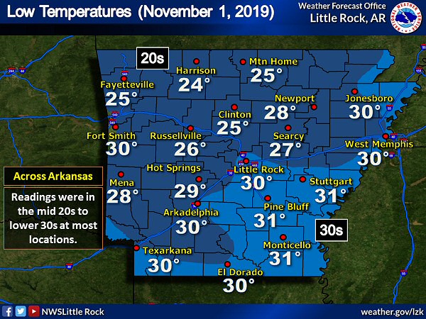
As October ended, it turned colder. After dark on the 31st, given a clear sky and light winds, the mercury dropped quickly. By 900 pm CDT, it was already 30 degrees at Fayetteville (Washington County) and Highfill (Benton County), 31 degrees at Mountain Home (Baxter County), and 32 degrees at Clinton (Van Buren County), Harrison (Boone County), and Mount Ida (Montgomery County). By the morning of November 1st, temperatures were subfreezing in much of Arkansas. In central/southern sections of the state, the freeze was a week to two weeks early (compared to normal).


In the video: Mild air on 11/10/2019 was replaced by much colder conditions a couple of days later after a cold front swept through Arkansas from the north.
 

There was more freezes early on the 8th/9th. On the 11th, a strong cold front drove from Canada into Arkansas, and promised to bring well below average temperatures and chances of wintry precipitation to the state.

Preceding the front, it was more like spring on the 10th. The high temperature at Harrison (Boone County) was 77 degrees, and it was 76 degrees at Flippin (Marion County), and 74 degrees at Fort Smith (Sebastian County) and Mountain Home (Baxter County).


In the picture: Several highways were partly snow and/or ice covered in northern Arkansas at 730 pm CST on 11/11/2019. The graphic is courtesy of IDriveArkansas.
 

Temperatures dropped like a rock during the afternoon of the 11th, and rain changed to snow and sleet toward the Missouri border. As readings dipped well below freezing, some roadways became partly snow and ice covered. It was also breezy, with north to northwest winds at 15 to 25 mph and gusts over 30 mph.

There was not enough moisture for heavy snow, and a warm ground kept accumulations minimal. In the end, Deer (Newton County) had two inches of flakes, with an inch of powder at Hardy (Sharp County), Pocahontas (Randolph County), and Salem (Fulton County).


High temperatures were up to 50 degrees colder on 11/12/2019 than a couple of days prior following a cold front. Thermometers showed teens and 20s at 500 am CST on 11/12/2019. At the same time, wind chill index values were below zero in parts of northwest Arkansas, and in the single digits and teens elsewhere.
48 Hour Temperature Change (11/10 to 11/12)  |  Temperatures at 500 am CST (11/12)
Wind Chill Index Values at 500 am CST (11/12)
In the pictures: High temperatures were up to 50 degrees colder on 11/12/2019 than a couple of days prior following a cold front. Thermometers showed teens and 20s at 500 am CST on 11/12/2019. At the same time, wind chill index values were below zero in parts of northwest Arkansas, and in the single digits and teens elsewhere.
 

By the morning of the 12th, temperatures were in the teens and 20s. Winds were still elevated at 500 am CST, and this created wind chill indices below zero in the northwest. The wind chill at Highfill (Benton County) was -3 degrees. It was -2 degrees at Bentonville (Benton County), and -1 degrees at Harrison (Boone County) and Siloam Springs (Benton County). Highs for the day were only in the 20s and 30s. At Harrison (Boone County), the high of 27 degrees was 50 degrees lower than the maximum on the 10th. It was 28 degrees at Mountain Home (Baxter County), which was a drop of 46 degrees.


In the picture: It was the second coldest November morning on record (since 1975) at North Little Rock (Pulaski County) on 11/12/2019 with a temperature of 18 degrees.
 

At North Little Rock (Pulaski County), the low of 18 degrees on the 12th made it the second coldest November morning on record locally. The high of 34 degrees at Little Rock (Pulaski County) tied for the 6th coldest November maximum (dating back to the 1870s).