The remnants of Tropical Storm Cristobal and widespread rain were expected to reach Arkansas by 06/08/2020.
In the picture: The remnants of Tropical Storm Cristobal and widespread rain were expected to reach Arkansas by 06/08/2020.
 

 In early June, Tropical Storm Cristobal ventured from the Yucatan Peninsula on the 5th to the Louisiana coast on the 7th. The system made landfall between the mouth of the Mississippi River and Grand Isle, LA at 510 pm CDT on the 7th with maximum sustained winds around 50 mph. The remnants of Cristobal continued northward into Arkansas on the 8th, and brought widespread downpours and northeast winds gusting from 30 to 40 mph in places. 


In the video: The satellite showed Tropical Storm Cristobal nearing the Louisiana Coast on 06/07/2020.
 

The barometric pressure was low enough to set a couple of June records. At North Little Rock (Pulaski County), the pressure bottomed out at 29.48 inches, which was under the previous low mark of 29.60 inches on the 6th of 1996. The barometer reading of 29.36 inches at Pine Bluff (Jefferson County) was 0.15 inch below the old record set on the 14th in 1998.


Twenty four hour rainfall through 700 am CDT on 06/09/2020.
In the picture: Twenty four hour rainfall through 700 am CDT on 06/09/2020.
 

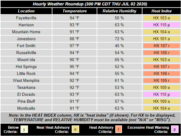
Overall, this did not turn into a huge event (impacts were minimal). Twenty hour hour rainfall through 700 am CDT on the 9th was mostly from one to three inches. Some locations received three to four inches including Cane Creek State Park (Lincoln County), DeGray Lake State Park (Clark/Hot Spring Counties), Marche (Pulaski County), Mammoth Spring (Fulton County), just north of Mountain Home (Baxter County), Mountain View (Stone County), and Sheridan (Grant County). In the far west, there was less than a quarter inch of liquid at De Queen (Sevier County), Fayetteville (Washington County), Fort Smith (Sebastian County), and Texarkana (Miller County).

Rivers did not get out of hand. However, the same rivers (Black, Cache, Ouachita, and Lower White) that had been elevated much of the year before the event were pushed a little higher.


Heat index values were between 100 and 110 degrees across Arkansas at 300 pm CDT on 07/02/2020.
In the picture: Heat index values were between 100 and 110 degrees across Arkansas at 300 pm CDT on 07/02/2020.
 

Climatologically, the hottest month of the year in Arkansas is July. While it was certainly hot on the 1st, with heat index values from 100 to 105 degrees in central and southern sections of the state, it was more oppressive on the 2nd and it affected much of the region. By 300 pm CDT on the 2nd, heat indices ranged from 100 to 110 degrees.

It was the same story on the 11th. High temperatures were in the 90s, with heat index values from 100 to around 115 degrees. At 400 pm CDT, heat indices reached 113 degrees at Arkadelphia (Clark County), 111 degrees at De Queen (Sevier County) and El Dorado (Union County), and 110 degrees at Fort Smith (Sebastian County) and Mena (Polk County).


It was not exactly scorching hot through the first forty eight days of meteorological summer (June 1 to July 18, 2020) in Little Rock (Pulaski County). There were only three days with temperatures at least 95 degrees. Since 1950, readings were this warm at least twenty days in thirteen years, and at least thirty days in three years (1952, 1954, and 2011).
In the picture: It was not exactly scorching hot through the first forty eight days of meteorological summer (June 1 to July 18, 2020) in Little Rock (Pulaski County). There were only three days with temperatures at least 95 degrees. Since 1950, readings were this warm at least twenty days in thirteen years, and at least thirty days in three years (1952, 1954, and 2011).
 

Overall, excessive heat was fleeting, with only three days with temperatures of at least 95 degrees at Little Rock (Pulaski County) from June 1st through July 18th. At Russellville (Pope County), readings were this warm only eight days, and it was fourteen days at Fort Smith (Sebastian County). At the latter site, it was not even close to the forty one days experienced in 2011.