Delta was the twenty fifth named storm of the 2020 tropical season in the Atlantic basin, and the tenth tropical system to make landfall (on 10/09/2020) in the United States (a record).
In the picture: Delta was the twenty fifth named storm of the 2020 tropical season in the Atlantic basin, and the tenth tropical system to make landfall (on 10/09/2020) in the United States (a record).
 

A very busy tropical season in the Atlantic basin continued in October. The remnants of Hurricane Delta were on the way to Arkansas after the system slammed into southwest Louisiana (as a Category 2 storm) during the evening of the 9th. This was the twenty fifth named storm of 2020, and a record tenth system to make landfall in the United States. This previous high mark was nine storms in 1916. 


What About Beta?

Preceding Delta was Tropical Storm Beta in late September. Beta spread heavy rain across southern Arkansas, and caused isolated flash flooding.

By the morning of the 22nd, downpours reached the southwest. As of 700 am CDT, Lewisville (Lafayette County) had 5.15 inches of rain, with 3.28 inches at Ashdown (Little River County) and 2.52 inches at Texarkana (Miller County).

In the next twenty four hours, heavy precipitation affected the southern half of the state. Four to five inch totals occurred at Kelso (Desha County), Nashville (Howard County), and Portland (Ashley County), with three to four inches at Malvern (Hot Spring County), Mount Ida (Montgomery County), and Murfreesboro (Pike County).

The deluge continued across the southeast counties on the 23rd/early on the 24th. Five to six inches of liquid was measured at Eudora (Chicot County) and Watson (Desha County). Roads were flooded at Dermott (Chicot County), and this stalled a vehicle along Highway 35. Streets were also under water at Hamburg (Ashley County) and McGehee (Desha County).


In the video: Rain spread across southern and eastern Arkansas as the remnants of Hurricane Delta approached from Louisiana early on 10/10/2020.
 

During the overnight hours of the 9th and into the 10th, Delta tracked to the northeast toward western Mississippi. Downpours spread into southern and eastern Arkansas.


Peak wind gusts were over 45 mph in parts of southeast Arkansas on 10/10/2020.
In the picture: Peak wind gusts were over 45 mph in parts of southeast Arkansas on 10/10/2020.
 

Winds picked up in the southeast on the 10th. A 48 mph gust was measured at Pine Bluff (Jefferson County), with a 47 mph gust at Monticello (Drew County), and a 41 mph gust at Stuttgart (Arkansas County). Winds were strong enough to down trees and/or power lines at Fountain Hill and Hamburg (both in Ashley County), at Dermott, Eudora, and Lake Village (all in Chicot County), and in Warren (Bradley County).


Several inches of rain dumped in southeast Arkansas in the forty eight hour period ending at 700 am CDT on 10/11/2020. More than a foot of precipitation fell from southwest into central Louisiana.
In the pictures: Several inches of rain dumped in southeast Arkansas in the forty eight hour period ending at 700 am CDT on 10/11/2020. More than a foot of precipitation fell from southwest into central Louisiana.
 

Two to more than three inches of rain fell at Beedeville (Jackson County), Cane Creek State Park (Lincoln County), Crossett (Ashley County), Fordyce (Dallas County), Kelso (Desha County), Monticello (Drew County), Pine Bluff (Jefferson County), and Thatcher Lock and Dam (Union County). North and west of Little Rock (Pulaski County), many locations received nary a drop of rain.


In the video: The satellite showed Hurricane Zeta and a well defined eye slamming into the Louisiana Gulf Coast about 65 miles south-southwest of New Orleans, LA during the late afternoon of 10/28/2020. At the same time, a powerful storm system was swirling in the southern Rockies and southern Plains. The video is courtesy of William Churchill via Twitter. 
 

Later in the month, drought conditions were slowly expanding in northwest Arkansas. Through the 25th, there was only 0.46 inch of rain at Fayetteville (Washington County), and Harrison (Boone County) had 0.63 inch. That was about to change. On the 28th, Arkansas was sandwiched between a hurricane (Zeta) to the east, and a snow and ice storm to the west (in New Mexico, Oklahoma, and Texas). The system responsible for the winter storm was headed this way.


There were many reports of an ice storm and accumulating snow to the west of Arkansas, and hurricane/tropical storm conditions south and east of the state in the sixty hour period ending at 700 pm CDT on 10/29/2020.
In the picture: There were many reports of an ice storm and accumulating snow to the west of Arkansas, and hurricane/tropical storm conditions south and east of the state in the sixty hour period ending at 700 pm CDT on 10/29/2020.
 

Instead of freezing or frozen precipitation, we got a gullywasher. Rain came down in buckets over the northern half of the state. In a ninety six hour period ending at 700 am CDT on the 30th, amounts exceeded six inches at several locations. This included Fayetteville (Washington County), Fort Smith (Sebastian County), Harrison (Boone County), and Mountain Home (Baxter County).


Ninety six hour (four day) rainfall through 700 am CDT on 10/30/2020.
In the picture: Ninety six hour (four day) rainfall through 700 am CDT on 10/30/2020.
 

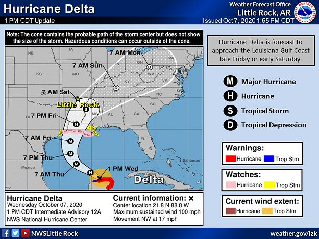
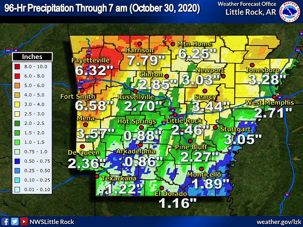
Three to four inch totals occurred at Jonesboro (Craighead County), Mena (Polk County), Newport (Jackson County), Searcy (White County), and Stuttgart (Arkansas County).

In and around Little Rock (Pulaski County), there was spotty flash flooding. At Sherwood (Pulaski County), an inch and a half of rain dumped in twenty minutes. The Little Rock Air Force Base (Pulaski County) got 1.66 inches in an hour.

The Buffalo River at St. Joe (Searcy County) shot up almost twenty feet (to 26.03 feet) on the 29th, and ended up just below the flood stage (of 27 feet). Water levels came up along the Black, Cache, and lower White Rivers, with minor flooding at a few forecast points.