ELEVATED CONVECTION

METEOROLOGIST JEFF HABY

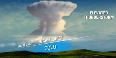
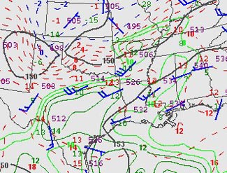
Notice that the Skew-T's on the web always have the parcel lapse rate beginning from the surface. This is not always the case in the real troposphere especially in the cool season. After a cold front passes, parcels of air no longer lift from the surface (remember that cold air is dense and resists upward motion more so than warm air). Rain that occurs behind a cold front or on the cool side of a warm front is not a result of parcels rising from the surface but by rather "elevated convection". Elevated convection is the convective lifting of air that initially begins to rise starting above the planetary boundary layer. When a front is involved (cold, warm, dryline) the parcels lift from the top of the front. On a sounding, a temperature inversion often marks the vertical depth of the front. Wind and dewpoint changes in the vertical can also help locate the vertical frontal boundary.

Parcels generally rise from the surface on days with air mass thunderstorms, upslope convection and rain/thunderstorms in the warm sector of a mid-latitude cyclone. Parcels of air do NOT necessarily rise from the surface when uplift mechanisms such as vorticity, jet streaks, isentropic lifting or frontal lifting is involved.

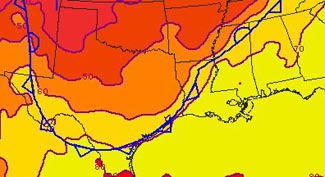
Why is this important? Because many of the indices (CAPE, LI, and others) assume parcels of air begin to rise from the surface. In a situation where "elevated convection" occurs, the convective surface will be higher in the troposphere and often just above an inversion, as mentioned earlier. Sounding software is required in order to have the parcel rise from the point you want on the Skew-T and calculate the indices. Elevated convection occurs on the cool side of a warm front, behind a cold front, near the circulation of a mid-latitude cyclone, in association with an upper level low and in cases where a jet streak or vort max forces air from the mid- levels of the troposphere to the upper levels of the troposphere (not necessarily all the way from the surface).

Convection that begins from the surface is termed thermodynamic convection or surface based convection. Convection originating from other means such as lifting from vorticity maximums, the cool side of fronts or jet streaks is termed dynamic convection. If thermodynamic and dynamic precipitation mechanisms override each other such as a jet streak and vort max overriding a PBL which is warm, humid and unstable... severe weather is likely (depending on magnitude of lifting mechanisms and wind shear environment). Thermodynamic convection alone in a barotropic environment will produce "air mass" thunderstorms, while dynamic mechanisms alone will produce elevated convection (especially if PBL is stable and/or dry).

TILTED FRONT -- ELEVATED STORMS

DR. GREG FORBED, THE WEATHER CHANNEL

Fronts at the surface are located on the warm edge of a zone of temperature transition. For a cold front, when the cold air is advancing, the front marks the beginning of the temperature decrease as a warm air mass is replaced with a cold one.

Usually the warm air is also the moist, unstable air. Thus, thunderstorms are typically found in the warm air mass ahead of and along the surface front.

The figure below shows the cold front (in blue) at the surface. It has driven southward and is offshore of all but far southern Texas. Temperatures, shown by color shading, begin to drop from the 70s (yellow) ahead of the front to the 50s in northeast TX and the 40s in the TX Panhandle.

What may surprise you from the radar figure below is the location of the thunderstorms having intense, red precipitation cores) over northeast Texas and northwest LA, well behind (north of) the surface cold front. Here temperatures at the surface were cool, in the 50s. These are "elevated thunderstorms," formed by lifting of air that is still warm, moist, and unstable at some level well above the surface. Other, weaker showers and thunderstorms are in more expected locations along and ahead of the front.

The cold front isn't a vertical wall. It is tilted with a triangular-shaped nose as it heads south. The cold air layer is thin at its leading edge, and much deeper at locations farther north. The map from 850 millibars (about 5000 feet above sea level; sea-level pressure is usually around 1000 mb) is shown below.

The 850 mb map doesn't show the front symbol, but it does show air temperatures, drawn by red and blue dashed lines called "isotherms." It also shows groupings of numbers and a wind flag plotted at each location where upper-air measurements were taken by weather balloons. The numbers in the upper-left quadrant of the data group are the air temperatures. The temperatures in south TX are mostly 13 or 14C (degrees Celsius). Near Dallas in north TX, though, the air temperature is 11C. Then you see lots of isotherms as you go northward across Oklahoma and into Kansas, where the air temperature at Dodge City is -1C.

From what we discussed above - that the front is found at the leading edge of the cold air mass - the cold front at this altitude runs from the base of the TX panhandle near Midland, TX to near Dallas in north TX and Shreveport in northwest LA.

The elevated thunderstorms on this occasion were being triggered at about 850 mb or 5000 feet, near the location of the front there. Lifting by the front and the deep layer of cold air below it there, was helping trigger the thunderstorms!

Elevated thunderstorms also occur as warm air is lifted above (usually north of) warm and stationary fronts, and are more common than behind cold fronts. Elevated thunderstorms sometimes bring hail, but do not normally pose much of a threat for tornadoes or damaging winds. That's because the layer of cold, stable air near the ground below an elevated thunderstorm tends to "insulate" the surface from the stronger winds and rotation in the storm aloft.