Overview
From Saturday, June 16 through early morning Tuesday, June 19, a slow-moving upper-level low pressure system across the Northwest United States coupled with anomalously high moisture (precipitable water values upwards of 150-175% of normal) led to a long-duration rainfall event across northeastern Wyoming and western South Dakota. Much of this moisture was advected into the area via the remnants of Hurricane Bud (thanks Bud-dy!) in the Pacific. Many places saw more rainfall in these three days than they had seen for the rest of June.
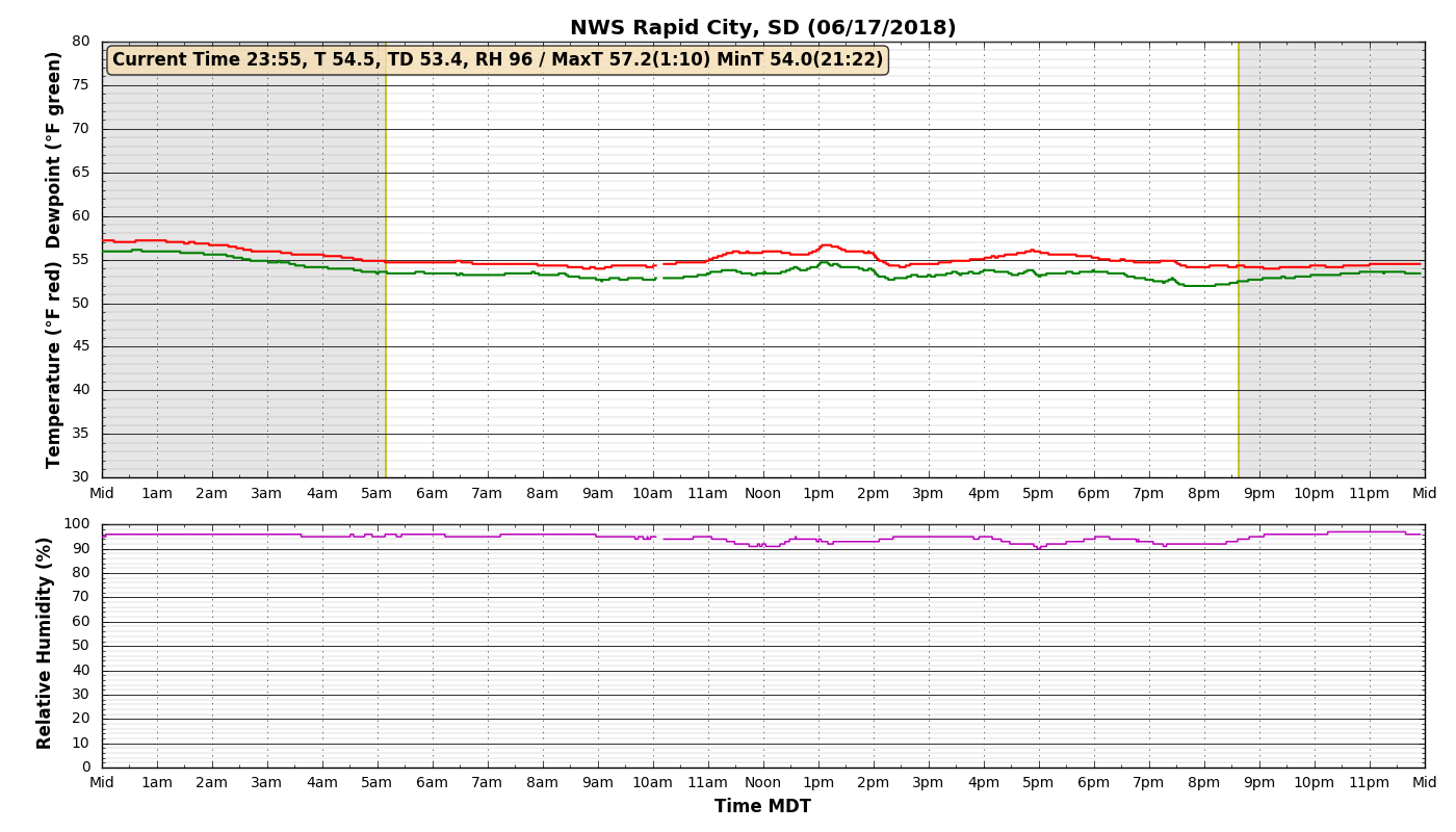
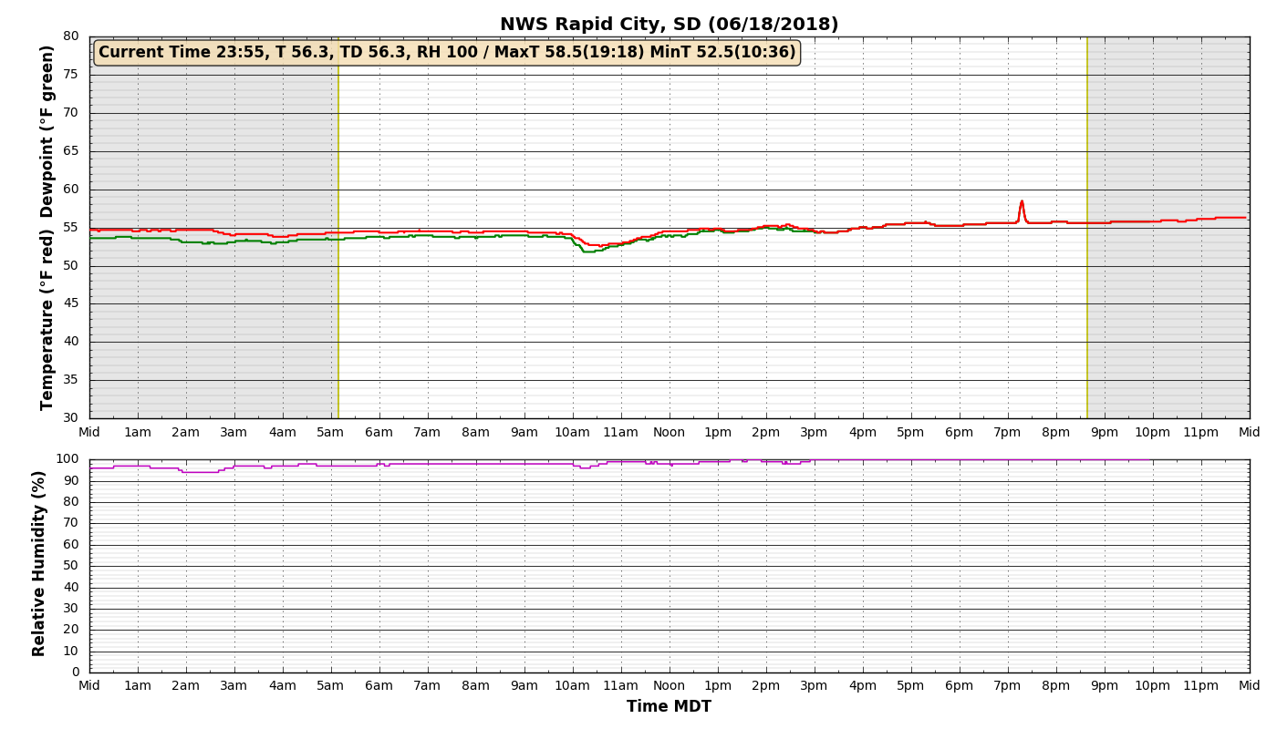
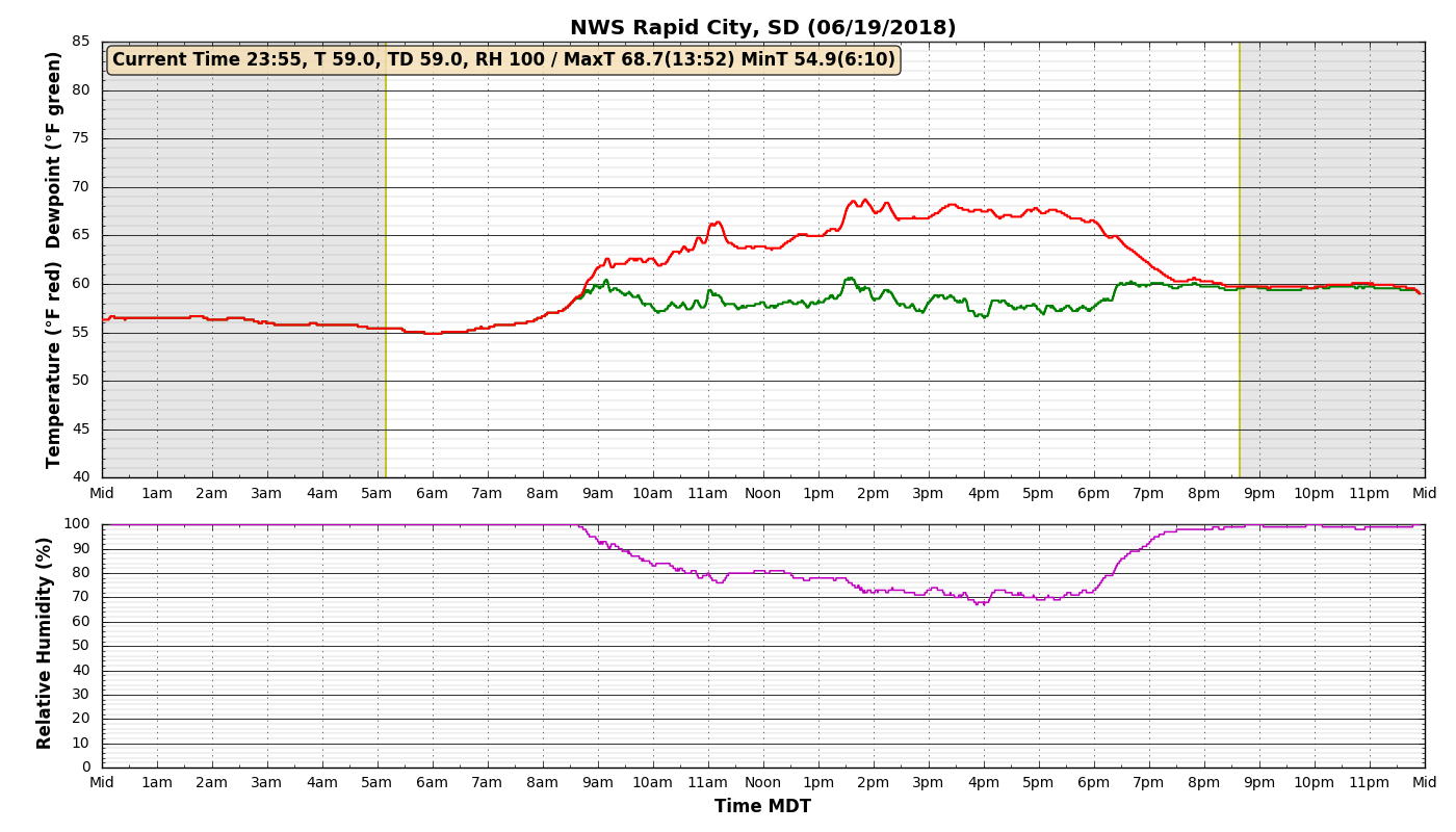
In addition to the widespread rainfall, ample cloud cover helped keep much of the region much cooler than normal with highs in the 50s and 60s. The temperature at the NWS Rapid City office only deviated by 6 degrees from midnight June 17 through 6 AM June 19 -- with a high of 57 degrees and a low of 51 in that time frame. Only once the low clouds broke and the sun made it's presence known (albeit briefly) through after 830 AM MDT did the temperature finally begin to climb out of the 50s in downtown Rapid City.
See images below for temperatures at NWS Rapid City June 17-19.
Rainfall
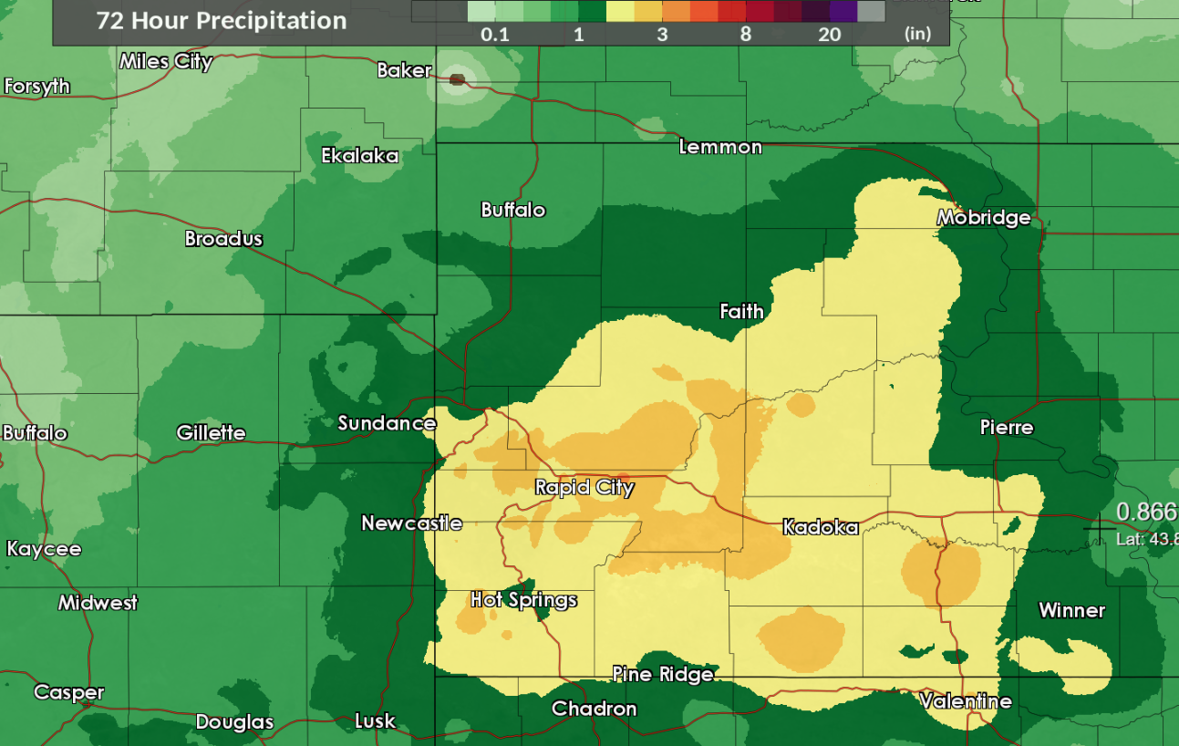
Rain Reports
Rain amounts (inches)

 AMOUNT  LOCATION                 ST  COUNTY           TIME
 ------  -----------------------  --  --------------   -------
  4.10   16 SSE MISSION           SD  TODD             0700 AM
                 STORM TOTAL RAINFALL 6/16-6/19
  3.94   9 ESE SAINT FRANCIS      SD  TODD             0700 AM
                 STORM TOTAL RAINFALL 6/16-6/19
  3.90   2 WNW SPRING CREEK       SD  TODD             0700 AM
                 STORM TOTAL RAINFALL 6/16-6/19
  3.87   7 E LAKEVIEW             SD  TODD             0700 AM
                 STORM TOTAL RAINFALL 6/16/-6/19
  3.31   4 W DOWNTOWN RAPID CITY  SD  PENNINGTON       0700 AM
                 STORM TOTAL RAINFALL 6/16-6/19
  3.30   1 NNW DOWNTOWN RAPID CI  SD  PENNINGTON       0700 AM
                 STORM TOTAL RAINFALL 6/16-6/19
  3.23   4 NW DOWNTOWN RAPID CIT  SD  PENNINGTON       0600 AM
                 STORM TOTAL RAINFALL 6/16/-6/19
  3.10   2 WSW HAMILL             SD  TRIPP            0700 AM
                 STORM TOTAL RAINFALL 6/16/-6/19
  3.07   2 SSW ARDMORE            SD  FALL RIVER       0700 AM
                 STORM TOTAL RAINFALL 6/16-6/19
  3.04   3 N DOWNTOWN RAPID CITY  SD  PENNINGTON       0700 AM
                 STORM TOTAL RAINFALL 6/16-6/19
  3.04   6 W NEW UNDERWOOD        SD  PENNINGTON       0700 AM
                 STORM TOTAL RAINFALL 6/16-6/19
  3.00   HERMOSA                  SD  CUSTER           0700 AM
                 STORM TOTAL RAINFALL 6/16-6/19
  2.99   14 NNE MARTIN            SD  BENNETT          0700 AM
                 STORM TOTAL RAINFALL 6/16-6/19
  2.99   5 W ELLSWORTH AFB        SD  MEADE            0700 AM
                 STORM TOTAL RAINFALL 6/16-6/19
  2.97   3 NNE JOHNSON SIDING     SD  PENNINGTON       0700 AM
                 STORM TOTAL RAINFALL 6/16-6/19
  2.96   2 SW DOWNTOWN NEWCASTLE  WY  WESTON           0700 AM
                 STORM TOTAL RAINFALL 6/16-6/19
  2.96   1 NE DOWNTOWN RAPID CIT  SD  PENNINGTON       0700 AM
                 STORM TOTAL RAINFALL 6/16-6/19
  2.95   2 SW NORRIS              SD  MELLETTE         0700 AM
                 STORM TOTAL RAINFALL 6/16-6/19
  2.87   1 NNW PIEDMONT           SD  MEADE            0745 AM
                 STORM TOTAL RAINFALL 6/16-6/19
  2.83   6 SSW MYSTIC             SD  PENNINGTON       0700 AM
                 STORM TOTAL RAINFALL 6/16-6/19
  2.79   21 SE MISSION            SD  TODD             0700 AM
                 STORM TOTAL RAINFALL 6/16-6/19
  2.74   4 SE NEMO                SD  LAWRENCE         0700 AM
                 STORM TOTAL RAINFALL 6/16-6/19
  2.74   3 SSE HISEGA             SD  PENNINGTON       0700 AM
  2.72   6 NNE WHITEWOOD          SD  LAWRENCE         0700 AM
                 STORM TOTAL RAINFALL 6/16-6/19
  2.72   1 N HISEGA               SD  PENNINGTON       0700 AM
                 STORM TOTAL RAINFALL 6/16-6/19
  2.72   4 S HILL CITY            SD  PENNINGTON       0700 AM
                 STORM TOTAL RAINFALL 6/16-6/19
  2.66   2 SW DOWNTOWN RAPID CIT  SD  PENNINGTON       0600 AM
                 STORM TOTAL RAINFALL 6/16-6/19
  2.63   3 SSE HILL CITY          SD  PENNINGTON       0700 AM
                 STORM TOTAL RAINFALL 6/16-6/19
  2.60   2 SW HISEGA              SD  PENNINGTON       0700 AM
  2.59   1 WSW DOWNTOWN NEWCASTL  WY  WESTON           0700 AM
  2.56   11 NE MORRISEY           WY  WESTON           0700 AM
                 STORM TOTAL RAINFALL 6/16-6/19
  2.56   4 NNE SUMMERSET          SD  MEADE            0700 AM
                 STORM TOTAL RAINFALL 6/16-6/19
  2.55   8 S SAINT FRANCIS        SD  TODD             0700 AM
                 STORM TOTAL RAINFALL 6/16-6/19
  2.53   1 ESE PACTOLA RESERVOIR  SD  PENNINGTON       0630 AM
                 STORM TOTAL RAINFALL 6/16/-6/19
  2.52   10 NNW WINNER            SD  TRIPP            0700 AM
                 STORM TOTAL RAINFALL 6/16-6/19
  2.50   2 E DOWNTOWN RAPID CITY  SD  PENNINGTON       0700 AM
                 STORM TOTAL RAINFALL 6/16/-6/19
  2.49   4 E DOWNTOWN RAPID CITY  SD  PENNINGTON       0700 AM
                 STORM TOTAL RAINFALL 6/16/-6/19
  2.49   1 WSW SILVER CITY        SD  PENNINGTON       0700 AM
  2.48   4 S HILL CITY            SD  PENNINGTON       0700 AM
  2.47   3 W SCENIC               SD  PENNINGTON       0700 AM
                 STORM TOTAL RAINFALL 6/16/-6/19
  2.46   5 NE HISEGA              SD  PENNINGTON       0700 AM
                 STORM TOTAL RAINFALL 6/16-6/19
  2.46   1 E DOWNTOWN RAPID CITY  SD  PENNINGTON       0600 AM
                 STORM TOTAL RAINFALL 6/16/-6/19
  2.43   7 N WOOD                 SD  MELLETTE         0700 AM
                 STORM TOTAL RAINFALL 6/16-6/19
  2.42   3 NE NORRIS              SD  MELLETTE         0700 AM
                 STORM TOTAL RAINFALL 6/16/-6/19
  2.40   3 NE HISEGA              SD  PENNINGTON       0700 AM
  2.40   TILFORD                  SD  MEADE            0700 AM
                 STORM TOTAL RAINFALL 6/16-6/19
  2.35   3 E HISEGA               SD  PENNINGTON       0700 AM
  2.33   2 ENE EDGEMONT           SD  FALL RIVER       0700 AM
                 STORM TOTAL RAINFALL 6/16-6/19
  2.32   EDGEMONT                 SD  FALL RIVER       0700 AM
                 STORM TOTAL RAINFALL 6/17 - 6/19
  2.32   1 NNE EDGEMONT           SD  FALL RIVER       0600 AM
                 STORM TOTAL RAINFALL 6/16/-6/19
  2.31   5 NW DOWNTOWN RAPID CIT  SD  PENNINGTON       0700 AM
                 STORM TOTAL RAINFALL 6/16-6/19
  2.31   1 W HISEGA               SD  PENNINGTON       0700 AM
  2.28   HILL CITY                SD  PENNINGTON       0700 AM
                 STORM TOTAL RAINFALL 6/16-6/19
  2.27   2 NW CENTRAL CITY        SD  LAWRENCE         0700 AM
                 STORM TOTAL RAINFALL 6/16-6/19
  2.24   7 WSW FOLSOM             SD  CUSTER           0700 AM
                 STORM TOTAL RAINFALL 6/16-6/19
  2.23   3 SW HILL CITY           SD  PENNINGTON       1011 AM
  2.22   7 NE SMITHWICK           SD  FALL RIVER       0700 AM
                 STORM TOTAL RAINFALL 6/16-6/19
  2.21   2 NE BOX ELDER           SD  PENNINGTON       0700 AM
                 STORM TOTAL RAINFALL 6/16-6/19
  2.20   3 WNW KADOKA             SD  JACKSON          0700 AM
                 STORM TOTAL RAINFALL 6/16-6/19
  2.18   7 NW CEDAR BUTTE         SD  MELLETTE         0700 AM
                 STORM TOTAL RAINFALL 6/16-6/19
  2.17   1 NNE EDGEMONT           SD  FALL RIVER       0700 AM
                 STORM TOTAL RAINFALL 6/16-6/19
  2.17   OELRICHS                 SD  FALL RIVER       0700 AM
                 STORM TOTAL RAINFALL 6/16/-6/19
  2.17   ORAL                     SD  FALL RIVER       0700 AM
                 STORM TOTAL RAINFALL 6/16/-6/19
  2.16   2 S PACTOLA RESERVOIR    SD  PENNINGTON       0700 AM
                 STORM TOTAL RAINFALL 6/16-6/19
  2.15   3 N HAYWARD              SD  PENNINGTON       0700 AM
                 STORM TOTAL RAINFALL 6/16-6/19
  2.15   7 NNE ELLSWORTH AFB      SD  MEADE            0700 AM
                 STORM TOTAL RAINFALL 6/16-6/19
  2.12   2 NNW MOUNT RUSHMORE     SD  PENNINGTON       0700 AM
  2.10   5 NW SWETT               SD  BENNETT          0750 AM
                 STORM TOTAL RAINFALL 6/16-6/19
  2.09   1 N IDEAL                SD  TRIPP            0700 AM
                 STORM TOTAL RAINFALL 6/16-6/19
  2.08   JOHNSON SIDING           SD  PENNINGTON       0700 AM
  2.06   1 ESE MOUNT RUSHMORE     SD  PENNINGTON       0700 AM
  2.03   19 SW UPTON              WY  WESTON           0700 AM
                 STORM TOTAL RAINFALL 6/16-6/19
  2.02   9 WNW FAIRBURN           SD  CUSTER           0700 AM
  2.02   4 W DOWNTOWN HOT SPRING  SD  FALL RIVER       0700 AM
                 STORM TOTAL RAINFALL 6/16-6/19
  2.01   7 ENE OSAGE              WY  WESTON           0700 AM
                 STORM TOTAL RAINFALL 6/16/-6/19
  2.01   LEAD                     SD  LAWRENCE         0400 PM
                 STORM TOTAL RAINFALL 6/16/-6/18
  2.00   3 SE SAINT ONGE          SD  LAWRENCE         0700 AM
                 STORM TOTAL RAINFALL 6/16-6/19
  1.97   4 S DOWNTOWN RAPID CITY  SD  PENNINGTON       0700 AM
                 STORM TOTAL RAINFALL 6/16/-6/19
  1.93   3 ESE CHEYENNE CROSSING  SD  LAWRENCE         0700 AM
                 STORM TOTAL RAINFALL 6/16-6/19
  1.91   2 E DOWNTOWN STURGIS     SD  MEADE            0600 PM
                 STORM TOTAL RAINFALL 6/16/-6/18
  1.88   3 E DOWNTOWN NEWCASTLE   WY  WESTON           0700 AM
                 STORM TOTAL RAINFALL 6/16-6/19
  1.88   1 SSE DOWNTOWN SPEARFIS  SD  LAWRENCE         0700 AM
                 STORM TOTAL RAINFALL 6/16-6/19
  1.86   1 E WINNER               SD  TRIPP            0700 AM
                 STORM TOTAL RAINFALL 6/16-6/19
  1.82   3 ENE KYLE               SD  OGLALA LAKOTA    0700 AM
                 STORM TOTAL RAINFALL 6/16/-6/19
  1.81   5 SE WHITEWOOD           SD  LAWRENCE         0700 AM
                 STORM TOTAL RAINFALL 6/16-6/19
  1.80   DOWNTOWN HOT SPRINGS     SD  FALL RIVER       0700 AM
                 STORM TOTAL RAINFALL 6/16-6/19
  1.78   5 SSW HILL CITY          SD  PENNINGTON       0700 AM
  1.78   DOWNTOWN HOT SPRINGS     SD  FALL RIVER       0700 AM
                 STORM TOTAL RAINFALL 6/16-6/19
  1.69   5 ESE ROSEBUD            SD  TODD             0700 AM
                 STORM TOTAL RAINFALL 6/16-6/19
  1.68   14 SW BILLSBURG          SD  HAAKON           0700 AM
                 STORM TOTAL RAINFALL 6/16-6/19
  1.68   EDGEMONT                 SD  FALL RIVER       0700 AM
                 STORM TOTAL RAINFALL 6/16-6/19
  1.67   6 SSW FAIRPOINT          SD  MEADE            0700 AM
                 STORM TOTAL RAINFALL 6/16-6/19
  1.65   DOWNTOWN HOT SPRINGS     SD  FALL RIVER       0400 PM
                 STORM TOTAL RAINFALL 6/16/-6/18
  1.55   12 S QUINN               SD  PENNINGTON       0700 AM
                 STORM TOTAL RAINFALL 6/16-6/19
  1.54   3 SSW ROSEBUD            SD  TODD             0700 AM
                 STORM TOTAL RAINFALL 6/16-6/19
  1.50   10 N OSAGE               WY  WESTON           0700 AM
                 STORM TOTAL RAINFALL 6/16-6/19
  1.49   6 ENE NEWELL             SD  BUTTE            0700 AM
                 STORM TOTAL RAINFALL 6/16/-6/19
  1.49   6 NNW DOWNTOWN SPEARFIS  SD  LAWRENCE         0700 AM
                 STORM TOTAL RAINFALL 6/16-6/19
  1.44   3 ENE NEWELL             SD  BUTTE            0700 AM
                 STORM TOTAL RAINFALL 6/16-6/19
  1.42   3 W RAPID VALLEY         SD  PENNINGTON       0700 AM
                 STORM TOTAL RAINFALL 6/16-6/19
  1.41   6 SW BEULAH              WY  CROOK            0700 AM
                 STORM TOTAL RAINFALL 6/16/-6/19
  1.39   1 NNE SUNDANCE           WY  CROOK            1200 AM
                 STORM TOTAL RAINFALL 6/16/-6/19
  1.34   4 ESE PINE HAVEN         WY  CROOK            0700 AM
                 STORM TOTAL RAINFALL 6/16-6/19
  1.33   1 N UPTON                WY  WESTON           0700 AM
                 STORM TOTAL RAINFALL 6/16-6/19
  1.32   9 ENE WEWELA             SD  TRIPP            0700 AM
                 STORM TOTAL RAINFALL 6/16-6/19
  1.31   4 SSW OKREEK             SD  TODD             0700 AM
                 STORM TOTAL RAINFALL 6/16-6/19
  1.31   8 SE MUD BUTTE           SD  MEADE            0700 AM
                 STORM TOTAL RAINFALL 6/16-6/19
  1.29   2 W OPAL                 SD  MEADE            0700 AM
                 STORM TOTAL RAINFALL 6/16/-6/19
  1.25   RED OWL                  SD  MEADE            0700 AM
                 STORM TOTAL RAINFALL 6/16/-6/19
  1.24   7 E PINE HAVEN           WY  CROOK            0700 AM
                 STORM TOTAL RAINFALL 6/16-6/19
  1.22   8 SSE BILLSBURG          SD  HAAKON           0700 AM
                 STORM TOTAL RAINFALL 6/16-6/19
  1.18   1 S DOWNTOWN BELLE FOUR  SD  BUTTE            0700 AM
                 STORM TOTAL RAINFALL 6/16-6/19
  1.09   19 SSE MISSION           SD  TODD             0700 AM
                 STORM TOTAL RAINFALL 6/16-6/19
  1.09   8 WNW USTA               SD  PERKINS          0700 AM
                 STORM TOTAL RAINFALL 6/16-6/19
 |
Media use of NWS Web News Stories is encouraged! Please acknowledge the NWS as the source of any news information accessed from this site. |
|


 Follow us on YouTube