A hourly weather graph forecast can be generated by going to the Hourly Graph website.
Guide to decoding the forecast below.
000
FNUS81 KBGM 151932
FWMBGM
FCST,301011,240516,13,2,72,58,2,1,NNE,08,,74,53,100,55,0,0,N
FCST,301011,240517,13,2,73,57,1,2,SSE,08,,77,52,100,50,0,0,N
FCST,301011,240518,13,2,67,68,2,2,SSE,09,,76,56,100,52,0,0,N
FCST,301011,240519,13,2,69,59,1,1,SSE,06,,71,53,100,57,0,0,N
FCST,301011,240520,13,1,75,47,1,1,WSW,03,,77,52,100,45,0,0,N
FCST,301011,240521,13,1,75,48,1,2,SSW,08,,79,53,93,42,0,0,N
FCST,301011,240522,13,2,76,55,2,1,SSW,12,,79,57,90,44,0,0,N
FCST,300171,240516,13,2,68,62,1,1,ENE,06,,69,51,100,61,0,0,N
FCST,300171,240517,13,2,69,58,1,2,SSE,08,,72,50,96,55,0,0,N
FCST,300171,240518,13,2,65,67,2,1,SSE,08,,72,53,96,53,0,0,N
FCST,300171,240519,13,2,67,60,1,1,SE,05,,69,51,96,57,0,0,N
FCST,300171,240520,13,1,71,51,1,1,W,03,,73,51,96,49,0,0,N
FCST,300171,240521,13,1,71,52,1,1,SSW,06,,75,52,93,46,0,0,N
FCST,300171,240522,13,2,72,59,1,1,SW,12,,74,55,90,49,0,0,N
FCST,361802,240516,13,2,65,72,1,1,NE,09,,66,54,96,70,0,0,N
FCST,361802,240517,13,2,70,56,1,1,ESE,05,,72,53,100,55,0,0,N
FCST,361802,240518,13,2,64,68,1,1,SE,05,,73,52,96,51,0,0,N
FCST,361802,240519,13,2,65,60,1,1,E,06,,66,51,100,58,0,0,N
FCST,361802,240520,13,2,71,52,1,1,ENE,04,,72,50,96,51,0,0,N
FCST,361802,240521,13,1,74,46,1,1,SSW,05,,75,51,93,45,0,0,N
FCST,361802,240522,13,2,75,55,1,1,SW,08,,76,55,93,45,0,0,N
FCST,360791,240516,13,2,65,69,1,1,NE,10,,66,50,96,65,0,0,N
FCST,360791,240517,13,2,66,64,1,1,SE,08,,68,50,100,61,0,0,N
FCST,360791,240518,13,2,59,78,1,1,SE,09,,68,51,96,61,0,0,N
FCST,360791,240519,13,2,62,68,1,1,E,06,,63,50,96,67,0,0,N
FCST,360791,240520,13,2,68,52,1,1,NNE,04,,70,49,96,51,0,0,N
FCST,360791,240521,13,1,70,52,1,1,SSW,06,,72,50,93,49,0,0,N
FCST,360791,240522,13,2,72,59,1,1,SW,11,,73,54,86,49,0,0,N
FCST,360792,240516,13,2,69,62,1,1,NNE,09,,72,51,96,57,0,0,N
FCST,360792,240517,13,2,70,59,1,1,SE,05,,75,52,96,54,0,0,N
FCST,360792,240518,13,2,62,75,1,1,SE,06,,75,52,93,53,0,0,N
FCST,360792,240519,13,2,65,64,1,1,E,05,,69,51,96,59,0,0,N
FCST,360792,240520,13,1,72,50,1,1,NNW,03,,75,50,96,46,0,0,N
FCST,360792,240521,13,1,74,50,1,1,SSW,06,,77,51,90,45,0,0,N
FCST,360792,240522,13,2,74,58,1,1,SW,10,,78,55,87,45,0,0,N
FCST,360151,240516,13,2,71,61,1,1,NNE,06,,71,52,100,59,0,0,N
FCST,360151,240517,13,2,71,61,1,1,SSE,06,,74,52,100,53,0,0,N
FCST,360151,240518,13,2,63,77,1,1,SSE,06,,72,55,100,59,0,0,N
FCST,360151,240519,13,2,66,65,1,1,ESE,05,,67,52,100,63,0,0,N
FCST,360151,240520,13,1,73,50,1,1,WNW,03,,73,52,100,49,0,0,N
FCST,360151,240521,13,1,73,52,1,1,SSW,06,,76,53,93,45,0,0,N
FCST,360151,240522,13,2,73,61,1,1,SW,10,,76,57,93,48,0,0,N
FCST,361031,240516,13,2,65,71,1,1,NNE,10,,65,52,100,70,0,0,N
FCST,361031,240517,13,2,69,60,1,1,ESE,06,,69,52,100,59,0,0,N
FCST,361031,240518,13,2,62,73,1,1,SE,06,,70,51,96,57,0,0,N
FCST,361031,240519,13,2,64,65,1,1,E,06,,64,50,100,63,0,0,N
FCST,361031,240520,13,2,69,55,1,1,ENE,04,,70,49,100,53,0,0,N
FCST,361031,240521,13,1,73,49,1,1,SSW,06,,73,50,96,48,0,0,N
FCST,361031,240522,13,2,73,59,1,1,SW,09,,74,53,96,48,0,0,N
FCST,300971,240516,13,1,68,65,2,1,N,09,,68,52,100,65,0,0,N
FCST,300971,240517,13,2,70,59,1,2,SSE,11,,71,52,100,57,0,0,N
FCST,300971,240518,13,2,65,70,2,2,SSE,10,,71,56,93,57,0,0,N
FCST,300971,240519,13,2,66,63,1,1,SSE,08,,67,53,96,63,0,0,N
FCST,300971,240520,13,1,70,54,1,1,W,04,,71,52,96,53,0,0,N
FCST,300971,240521,13,1,71,52,1,2,SSW,08,,74,54,93,46,0,0,N
FCST,300971,240522,13,2,71,61,2,1,SSW,13,,73,57,90,49,0,0,N
000
FNUS51 KBGM 151931
FWFBGM
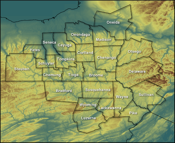
Fire Weather Planning Forecast for Central NY/Northeast PA
National Weather Service Binghamton NY
330 PM EDT Wed May 15 2024
.SYNOPSIS...
Rain showers come to an end this evening. Patchy fog is possible
overnight and Thursday morning, especially in low lying areas.
Warmer conditions return Thursday with mostly dry conditions to
finish out the work week, though afternoon scattered showers will
be
possible both Thursday and Friday.
NYZ210-160800-
Leatherstocking-
330 PM EDT Wed May 15 2024
Tonight Thu Thu Night Fri
Cloud Cover Mcldy Pcldy Pcldy Pcldy
Precip Type Showers Showers None Tstms
Chance Precip (%) 30 20 0 20
Temp (24h trend) 50 (-6) 72 (+9) 50 74
RH % (24h trend) 100 (0) 51 (+13) 100 49
20ft Wnd-Val/AM(mph) NE 3-7 SE 3-7
20ft Wnd-Rdg/PM(mph) Lgt/Var NE 6-10 E 3-7 SE 6-10
Precip Amount 0.01 0.00 0.00 0.00
Precip Duration 1 1 0
Precip Begin 6 PM 11 AM 2 PM
Precip End 12 AM 6 PM Continuing
Mixing Hgt(ft-agl/msl) 4110 4910
Transport Wnd (mph) NE 12 SE 13
Vent Rate (kt-ft) 56920 68020
DSI 1 2 2 2
Sunshine Hours 7 5
LAL No tstms No tstms No tstms 1-8 strikes
Haines Index 3 3 3 3
ADI early 13 Gen Poor 39 Fair 24 Fair 40 Fair
ADI late 3 Very Poor 41 Gen Good 5 Very Poor 51 Gen Good
Max LVORI early 6 8 6 6
Max LVORI late 9 3 7 1
Remarks: ADI is Atmospheric Dispersion Index by Lavdas.
LVORI is Low Visibility Occurrence Risk Index.
.FORECAST FOR DAYS 3 THROUGH 7...
.SATURDAY...Mostly cloudy with a 50 percent chance of showers.
Lows in the mid 50s. Highs in the upper 60s. Southeast winds
around 10 mph.
.SUNDAY...Mostly cloudy. A slight chance of showers. Lows in the
lower 50s. Highs around 70. East winds around 5 mph.
.MONDAY...Partly cloudy. Lows in the lower 50s. Highs in the mid
70s. East winds around 5 mph.
.TUESDAY...Partly cloudy. A slight chance of showers. Lows in the
lower 50s. Highs in the mid 70s. South winds around 5 mph.
.WEDNESDAY...Partly cloudy. A chance of showers and a slight
chance of thunderstorms. Lows in the mid 50s. Highs in the mid
70s. Chance of precipitation 50 percent. South winds around
10 mph.
$$
PAZ038-039-043-160800-
Bradford-Susquehanna-Wyoming-
Including the cities of Sayre, Towanda, Hallstead, Montrose,
and Tunkhannock
330 PM EDT Wed May 15 2024
Tonight Thu Thu Night Fri
Cloud Cover Pcldy Pcldy Pcldy Mcldy
Precip Type Showers Showers None Showers
Chance Precip (%) 20 20 0 20
Temp (24h trend) 50 (-6) 74 (+11) 51 72
RH % (24h trend) 100 (0) 51 (-9) 100 55
20ft Wnd-Val/AM(mph) NE 4-8 Lgt/Var
20ft Wnd-Rdg/PM(mph) Lgt/Var NE 6-10 E 3-7 SE 5-9
Precip Amount 0.01 0.00 0.00 0.00
Precip Duration 0 0 0
Precip Begin 6 PM 3 PM 2 PM
Precip End 8 PM 6 PM Continuing
Mixing Hgt(ft-agl/msl) 4490 4670
Transport Wnd (mph) NE 13 SE 12
Vent Rate (kt-ft) 60140 60790
DSI 1 2 2 2
Sunshine Hours 7 4
LAL No tstms No tstms No tstms No tstms
Haines Index 3 3 3 3
ADI early 16 Gen Poor 46 Gen Good 30 Fair 37 Fair
ADI late 4 Very Poor 52 Gen Good 4 Very Poor 46 Gen Good
Max LVORI early 6 8 6 8
Max LVORI late 9 2 8 2
Remarks: ADI is Atmospheric Dispersion Index by Lavdas.
LVORI is Low Visibility Occurrence Risk Index.
.FORECAST FOR DAYS 3 THROUGH 7...
.SATURDAY...Mostly cloudy with a 50 percent chance of showers.
Lows in the mid 50s. Highs in the mid 60s. Southeast winds 5 to
10 mph.
.SUNDAY...Mostly cloudy. A 50 percent chance of showers. Lows in
the lower 50s. Highs in the upper 60s. East winds around 5 mph.
.MONDAY...Mostly cloudy. Lows in the lower 50s. Highs in the mid
70s. East winds around 5 mph.
.TUESDAY...Partly cloudy. A slight chance of showers. Lows in the
lower 50s. Highs in the mid 70s. Southwest winds around 5 mph.
.WEDNESDAY...Partly cloudy. A chance of showers and a slight
chance of thunderstorms. Lows in the mid 50s. Highs in the mid
70s. Chance of precipitation 50 percent. South winds around
10 mph.
$$
PAZ044-047-160800-
Lackawanna-Luzerne-
Including the cities of Scranton, Hazleton, and Wilkes-Barre
330 PM EDT Wed May 15 2024
Tonight Thu Thu Night Fri
Cloud Cover Pcldy Pcldy Pcldy Mcldy
Precip Type None None None None
Chance Precip (%) 0 0 0 0
Temp (24h trend) 50 (-6) 73 (+10) 51 73
RH % (24h trend) 100 (0) 51 (+3) 100 49
20ft Wnd-Val/AM(mph) NE 5-9 Lgt/Var
20ft Wnd-Rdg/PM(mph) E 3-7 NE 6-10 NE 3-7 SE 4-8
Precip Amount 0.00 0.00 0.00 0.00
Precip Duration
Precip Begin
Precip End
Mixing Hgt(ft-agl/msl) 4100 4670
Transport Wnd (mph) NE 17 SE 12
Vent Rate (kt-ft) 73220 58230
DSI 1 2 2 2
Sunshine Hours 6 4
LAL No tstms No tstms No tstms No tstms
Haines Index 3 3 3 3
ADI early 27 Fair 58 Gen Good 30 Fair 33 Fair
ADI late 7 Poor 61 Good 5 Very Poor 44 Gen Good
Max LVORI early 6 6 5 6
Max LVORI late 7 2 7 2
Remarks: ADI is Atmospheric Dispersion Index by Lavdas.
LVORI is Low Visibility Occurrence Risk Index.
.FORECAST FOR DAYS 3 THROUGH 7...
.SATURDAY...Mostly cloudy with a 50 percent chance of showers.
Lows in the lower 50s. Highs in the mid 60s. Southeast winds
around 5 mph.
.SUNDAY...Mostly cloudy with a 50 percent chance of showers. Lows
in the lower 50s. Highs in the upper 60s. East winds around
5 mph.
.MONDAY...Mostly cloudy. Lows in the lower 50s. Highs in the
lower 70s. Northeast winds around 5 mph.
.TUESDAY...Partly cloudy. A slight chance of showers. Lows in the
lower 50s. Highs in the mid 70s. Southwest winds around 5 mph.
.WEDNESDAY...Partly cloudy. A chance of showers and a slight
chance of thunderstorms. Lows in the mid 50s. Highs in the mid
70s. Chance of precipitation 50 percent. South winds around
5 mph.
$$
PAZ040-048-072-160800-
Northern Wayne-Pike-Southern Wayne-
Including the cities of Damascus, Equinunk, Milford,
and Honesdale
330 PM EDT Wed May 15 2024
Tonight Thu Thu Night Fri
Cloud Cover Mcldy Mcldy Pcldy Mcldy
Precip Type Showers Showers None None
Chance Precip (%) 20 20 0 0
Temp (24h trend) 51 (-4) 68 (+7) 51 70
RH % (24h trend) 100 (0) 59 (0) 100 51
20ft Wnd-Val/AM(mph) NE 6-10 E 3-7
20ft Wnd-Rdg/PM(mph) E 3-7 NE 7-11 NE 4-8 SE 4-8
Precip Amount 0.01 0.00 0.00 0.00
Precip Duration 1 1
Precip Begin 6 PM Continuing
Precip End Continuing 6 PM
Mixing Hgt(ft-agl/msl) 3550 4980
Transport Wnd (mph) NE 17 SE 12
Vent Rate (kt-ft) 62490 61430
DSI 1 2 2 2
Sunshine Hours 4 4
LAL No tstms No tstms No tstms No tstms
Haines Index 3 3 3 3
ADI early 25 Fair 56 Gen Good 23 Fair 37 Fair
ADI late 9 Poor 56 Gen Good 6 Very Poor 48 Gen Good
Max LVORI early 6 6 6 7
Max LVORI late 7 3 8 2
Remarks: ADI is Atmospheric Dispersion Index by Lavdas.
LVORI is Low Visibility Occurrence Risk Index.
.FORECAST FOR DAYS 3 THROUGH 7...
.SATURDAY...Mostly cloudy with a 40 percent chance of showers.
Lows in the lower 50s. Highs in the mid 60s. Southeast winds
around 5 mph.
.SUNDAY...Mostly cloudy with a 40 percent chance of showers. Lows
in the lower 50s. Highs in the mid 60s. East winds around 5 mph.
.MONDAY...Mostly cloudy. Lows in the upper 40s. Highs in the
lower 70s. Northeast winds around 5 mph.
.TUESDAY...Partly cloudy. A slight chance of showers. Lows in the
lower 50s. Highs in the lower 70s. Southwest winds around 5 mph.
.WEDNESDAY...Partly cloudy. A chance of showers and a slight
chance of thunderstorms. Lows in the mid 50s. Highs in the mid
70s. Chance of precipitation 50 percent. South winds around
5 mph.
$$


 Follow us on YouTube