National Weather Service United States Department of Commerce

Severe Thunderstorms and Flash Flooding Concerns Across the Southern Plains

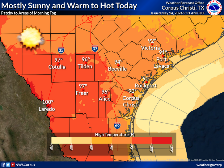
Severe thunderstorms capable of producing large hail, damaging winds and tornadoes are expected to develop this afternoon from western Oklahoma into west-central Texas. An Enhanced Risk (level 3 of 5) of severe thunderstorms in effect. Heavy to excessive rainfall is also likely for central and eastern Texas. Multiple rounds of heavy rainfall will lead to flash, urban and river flooding. Read More >

Click a location below for detailed forecast.

Last Map Update: Wed, May. 1, 2024 at 5:36:25 pm CDT

National Weather Service Austin/San Antonio, TXNational Weather Service Austin/San Antonio, TXNational Weather Service Houston/Galveston, TX
National Weather Service Austin/San Antonio, TXZoom
Out

National Weather Service Brownsville/Rio Grande Valley, TXNational Weather Service Brownsville/Rio Grande Valley, TX

Minor coastal flooding and dangerous rip currents are likely along the middle Texas coast today and tonight.
Today will be mostly cloudy with a HIGH risk of rip currents. Minor coastal flooding is also likely around high tide. Flooding of lots, parks, and beach access roads with only isolated closures are expected.
There will be a medium chance (30-50%) of showers this afternoon along with a low chance (less than 20%) for an isolated thunderstorm. High temperatures will range from the mid 80s to low 90s.
There is a low chance of showers and thunderstorms each day through Saturday. There will be an increasing risk for heat related impacts next week.

 
Hourly Weather Roundup ( )
Location Sky/Weather Temp Dewpt RH Wind Baro Remarks
Alice
N/A
N/A
N/A
N/A
N/A
N/A
N/A
Beeville
N/A
N/A
N/A
N/A
N/A
N/A
N/A
Corpus Christi
N/A
N/A
N/A
N/A
N/A
N/A
N/A
Corpus Christi NAS
N/A
N/A
N/A
N/A
N/A
N/A
N/A
Cotulla
N/A
N/A
N/A
N/A
N/A
N/A
N/A
Kingsville NAS
N/A
N/A
N/A
N/A
N/A
N/A
N/A
Laredo
N/A
N/A
N/A
N/A
N/A
N/A
N/A
Port Lavaca
N/A
N/A
N/A
N/A
N/A
N/A
N/A
Rockport
N/A
N/A
N/A
N/A
N/A
N/A
N/A
Victoria
N/A
N/A
N/A
N/A
N/A
N/A
N/A
Note: "N/A" or "MISG" will be displayed if values are not available. In the LOCATION column, click on links for a list of recent observations at sites of interest. In the WIND column, VRB is "variable" and G is "gust". Wind speeds are in MPH. In the BARO (pressure) column, values are in inches. In the REMARKS column, HX is "heat index", WCI is "wind chill index", and VSB is "visibility" (if shown).
 
Text Product Selector
Video Briefing Weather Outlook Fcst Discussion Tropical Marine Tides
Rivers and Lakes Daily Rainfall Drought Fire Observations Satellite

Hourly Wx Graph Graphical Fcst Aviation Climate Past Events Hurricane Guide