Overview
|
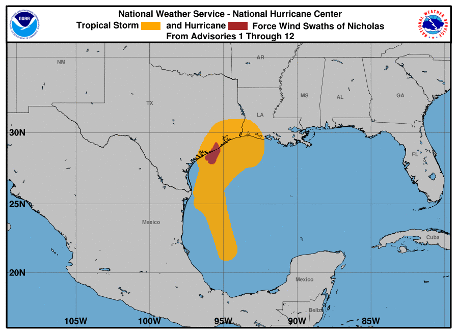
On Sunday, September 12, Tropical Storm Nicholas formed in the southwestern Gulf of Mexico, about 130 miles northeast of Veracruz, Mexico. It strengthened gradually as it moved northward along the western edge of the Gulf of Mexico, bringing rains to the Texas Gulf Coast as it slid along its track not far off the coastline through Sunday and Monday. On Monday night, shortly before it made landfall, Nicholas was upgraded to a hurricane as it produced wind gusts as high as 94 mph at a WeatherFlow sensor on Matagorda Bay. The storm made landfall shortly after midnight on Tuesday about 10 miles west-southwest of Sargent Beach, in rural Matagorda County. Through Monday night and into Tuesday morning, the storm brought gusty winds to much of coastal Southeast Texas, resulting in power outages to nearly half a million people. It also dumped several inches of rain on the Southeast Texas Gulf Coast and barrier islands, resulting in flash flooding. |
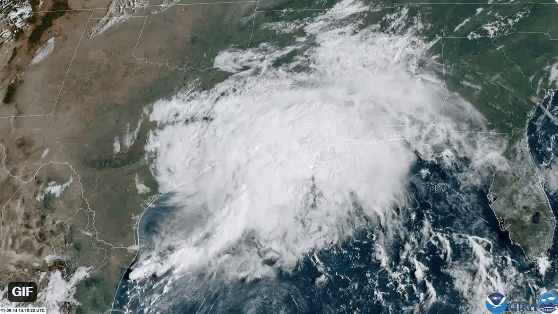 GOES-East visible imagery showing Nicholas moving slowly across Southeast Texas. (Satellite loop taken on 9/14 at 1pm CDT) |
 |
 |
 |
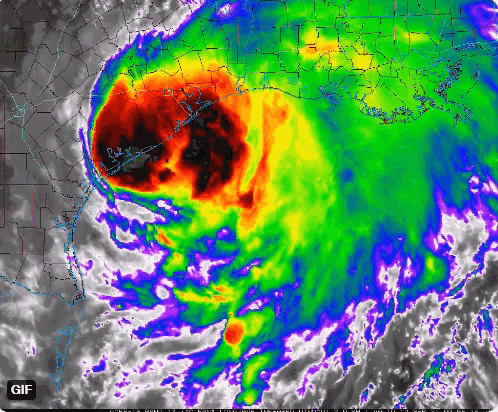
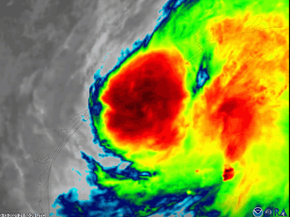
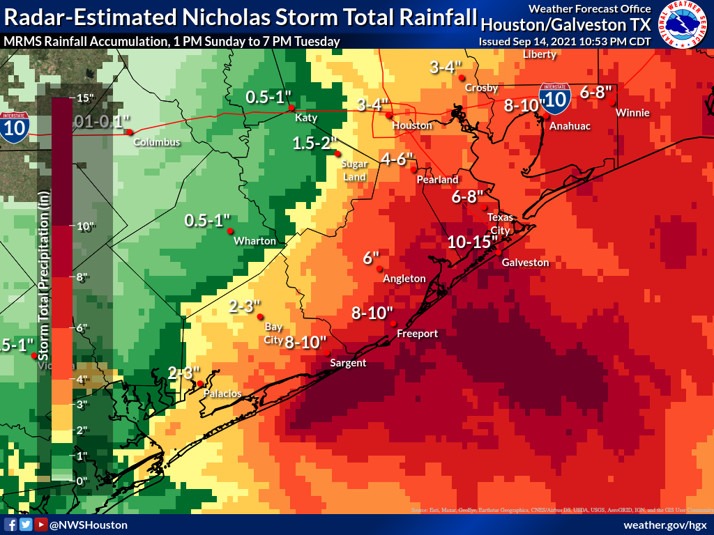
| GOES-15 infrared (band 10) showing Nicholas strengthening into a hurricane along the Texas coast. (Source: NOAA/CIRA) | MRMS-estimated rainfall totals for Hurricane Nicholas | Radar loop from Nicholas an hour after making landfall near Sargent Beach, TX. (Radar loop at 2:30 am 09/14) |
Wind:
This section will host information about the wind impacts of Hurricane Nicholas in the Houston/Galveston County Warning Area.
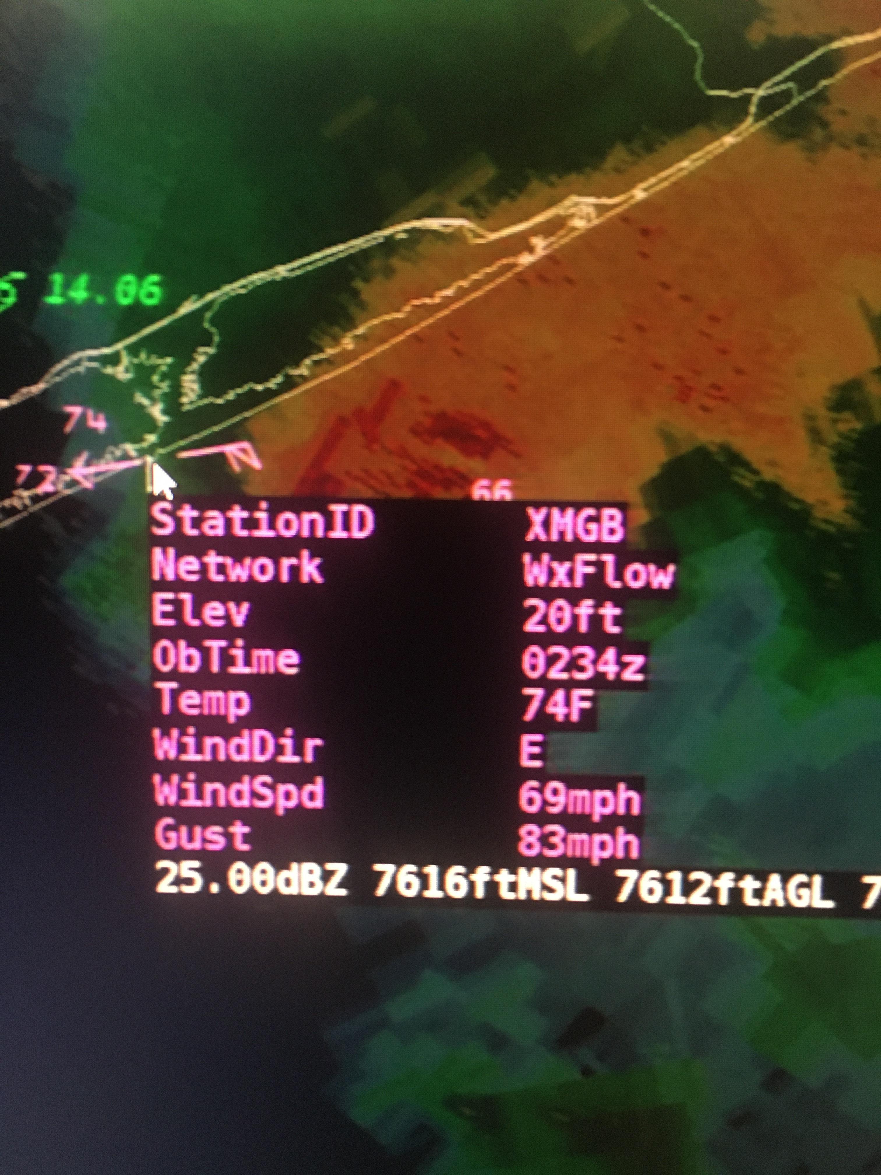 |
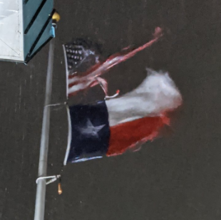 |
| A Monday evening wind observation from Matagorda Bay as Nicholas neared landfall | A picture of the flagpole at the Galveston County Office of Emergency Management. Picture taken by Cameron Batiste |
Wind Reports
This is a preliminary list of wind speed reports received by WFO Houston/Galveston with Hurricane Nicholas. The collection of wind speed data will be refined in the days to come as an official report is compiled. In the meantime, please use caution with this preliminary data. A more detailed note on this data is provided at the bottom of the section.
LOCATION                     SPEED     TIME/DATE       LAT/LON

MATAGORDA BAY                94 MPH    0939 PM 09/13   28.59N/95.98W
BRAZOS 451 OILP              81 MPH    1055 PM 09/13   28.50N/95.72W
46 SSW JONES CREEK           81 MPH    1055 PM 09/13   28.31N/95.62W
13 ESE MAGNOLIA BEACH        81 MPH    0748 PM 09/13   28.42N/96.33W
1 SSW SURFSIDE BEACH         78 MPH    1200 AM 09/14   28.94N/95.29W
PALACIOS                     77 MPH    0833 PM 09/13   28.72N/96.25W
PORT OCONNOR, TX             75 MPH    0736 PM 09/13   28.45N/96.39W
18 S BAY CITY                74 MPH    0954 PM 09/13   28.71N/95.91W
LEVEE                        70 MPH    0332 AM 09/14   29.42N/94.89W
11 SW JAMAICA BEACH          69 MPH    0100 AM 09/14   29.08N/95.12W
GALVESTON BAY ENTRANCE, NORT 68 MPH    0324 AM 09/14   29.36N/94.72W
GALVESTON FISHING PIER       68 MPH    1254 AM 09/14   29.25N/94.85W
SAN BERNARD NWR              66 MPH    1229 AM 09/14   28.86N/95.57W
TEXAS CORINTHIAN YACHT CLUB  64 MPH    0311 AM 09/14   29.53N/95.00W
BRAZORIA NWR                 63 MPH    0128 AM 09/14   29.15N/95.30W
HOUSTON UNIV                 63 MPH    0355 AM 09/14   29.72N/95.40W
CLEAR LAKE PARK              63 MPH    0422 AM 09/14   29.56N/95.07W
GALVESTON                    62 MPH    1236 AM 09/14   29.27N/94.87W
BAY CITY                     61 MPH    1135 PM 09/13   28.97N/95.87W
MORGANS POINT, TX            61 MPH    0506 AM 09/14   29.68N/94.98W
TEXAS CITY                   61 MPH    0221 AM 09/14   29.37N/94.95W
70 S QUINTANA                60 MPH    0610 PM 09/13   27.91N/95.34W
EAGLE POINT, TX              60 MPH    0342 AM 09/14   29.48N/94.92W
PEARLAND                     60 MPH    0216 AM 09/14   29.52N/95.25W
FREEPORT                     59 MPH    0956 PM 09/13   28.94N/95.35W
GALVESTON                    59 MPH    1249 AM 09/14   29.20N/94.93W
2 ESE BAYOU VISTA            59 MPH    1154 PM 09/13   29.30N/94.90W
HOUSTON HOBBY                58 MPH    0244 AM 09/14   29.63N/95.28W
GALVESTON BAY                58 MPH    0309 AM 09/14   29.54N/94.91W
MORGANS POINT                57 MPH    0455 AM 09/14   29.68N/95.01W
8 NE GALVESTON               57 MPH    0248 AM 09/14   29.31N/94.79W
28 E GALVESTON               56 MPH    0310 AM 09/14   29.23N/94.41W
1 SW KEMAH                   56 MPH    0205 AM 09/14   29.52N/95.04W
LA PORTE MUNICIPAL AIRPORT   55 MPH    0335 AM 09/14   29.67N/95.06W
CRAB LAKE                    55 MPH    0349 AM 09/14   29.47N/94.62W
4 SSW PASADENA               53 MPH    0250 AM 09/14   29.60N/95.17W
HOUSTON                      52 MPH    0415 AM 09/14   29.61N/95.18W
HOUSTON EXEC                 52 MPH    0435 AM 09/14   29.80N/95.90W
HOUSTON INTNL                51 MPH    0648 AM 09/14   30.00N/95.37W
HOUSTON SUGAR LA             51 MPH    0353 AM 09/14   29.62N/95.65W
5.6 W EAST BERNARD (UPR)     50 MPH    0440 AM 09/14   29.54N/96.15W
1 NNE PORT LAVACA            49 MPH    0518 PM 09/13   28.64N/96.61W
LOLITA                       48 MPH    0648 PM 09/13   28.79N/96.55W
VANDERBILT                   48 MPH    0706 PM 09/13   28.82N/96.62W
SANTA FE                     47 MPH    1240 AM 09/14   29.36N/95.13W
PALACIOS                     47 MPH    0718 PM 09/13   28.73N/96.42W
HOUSTON                      47 MPH    0319 AM 09/14   29.64N/95.13W
1 E FREEPORT                 47 MPH    1135 PM 09/13   28.95N/95.34W
SAN LEON                     46 MPH    0401 AM 09/14   29.50N/94.95W
THOMPSONS                    46 MPH    0246 AM 09/14   29.48N/95.63W
13 S STOWELL                 46 MPH    0448 AM 09/14   29.59N/94.39W
WHARTON                      46 MPH    0235 AM 09/14   29.25N/96.15W
HOUSTON                      45 MPH    0437 AM 09/14   29.74N/95.39W
PASADENA                     45 MPH    0329 AM 09/14   29.60N/95.11W
GALVESTON                    45 MPH    0647 PM 09/13   29.20N/94.94W
ANAHUAC                      45 MPH    0812 AM 09/14   29.67N/94.44W
HOUSTON DW HOOKS             45 MPH    0545 AM 09/14   30.07N/95.55W
12.4 SW EAGLE LAKE (TWDB)    44 MPH    0945 PM 09/13   29.44N/96.44W
HOUSTON                      43 MPH    0331 AM 09/14   29.55N/95.08W
3.7 W ROSENBERG (UPR)        43 MPH    0530 AM 09/14   29.56N/95.86W
HOUSTON                      42 MPH    0501 AM 09/14   29.78N/95.37W
SUGAR LAND                   42 MPH    0358 AM 09/14   29.54N/95.67W
EDNA                         41 MPH    0750 PM 09/13   28.94N/96.52W
EL LAGO                      41 MPH    0101 AM 09/14   29.56N/95.05W
HOUSTON                      41 MPH    0436 AM 09/14   29.80N/95.41W
CONROE                       41 MPH    0815 AM 09/14   30.35N/95.42W
SPRING                       40 MPH    0831 AM 09/14   30.12N/95.39W


OBSERVATIONS ARE COLLECTED FROM A VARIETY OF SOURCES WITH VARYING
EQUIPMENT AND EXPOSURES. WE THANK ALL VOLUNTEER WEATHER OBSERVERS
FOR THEIR DEDICATION. NOT ALL DATA LISTED ARE CONSIDERED OFFICIAL.
Flooding:
This section will host information about the flooding impacts of Hurricane Nicholas from heavy rains along the Gulf Coast.
Photos
 |
 |
 |
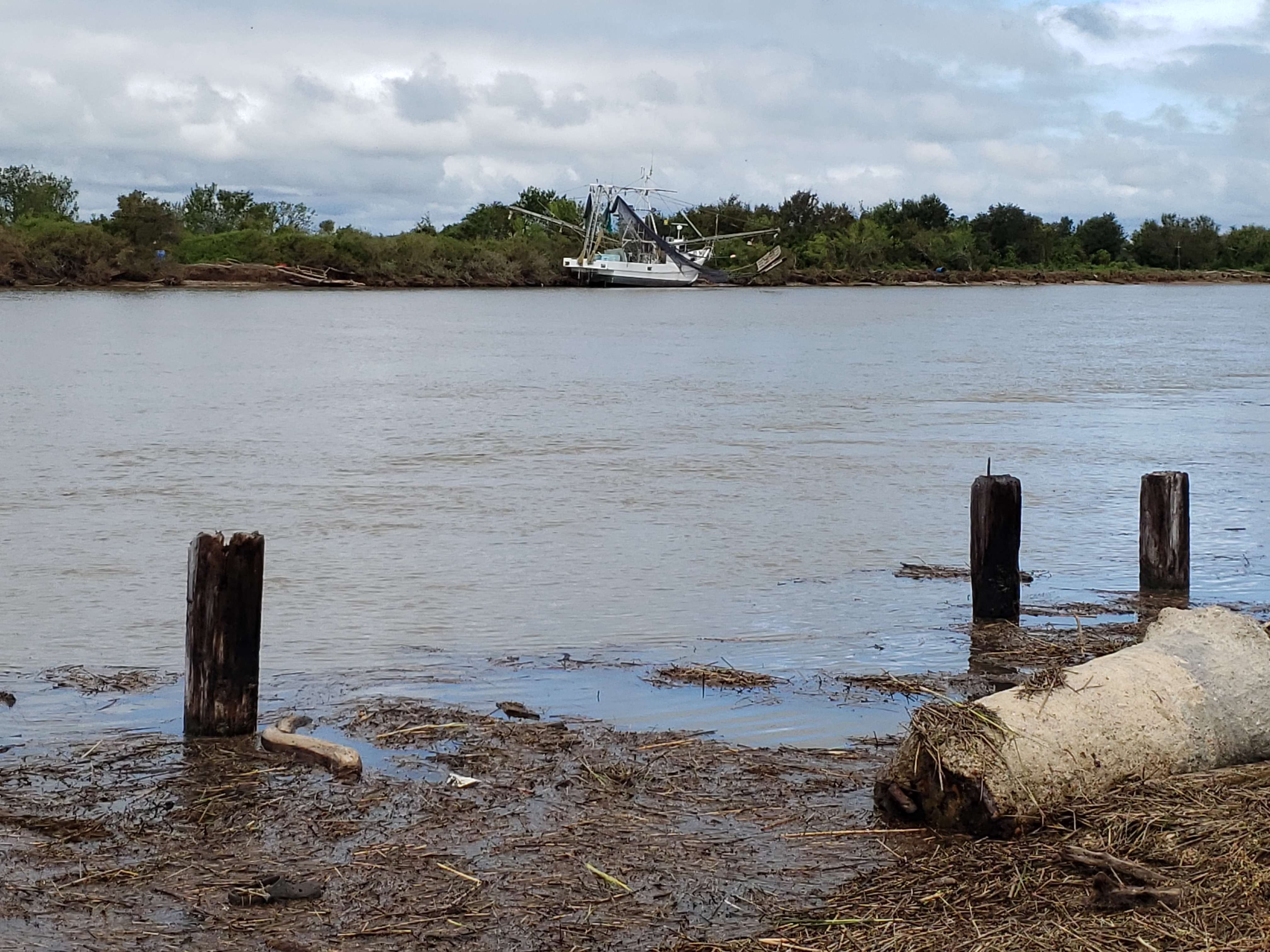
 |
| Boat, trawler pushed grounded. Vegetative debris in Intracoastal Waterway. (Source: NWS Houston) |
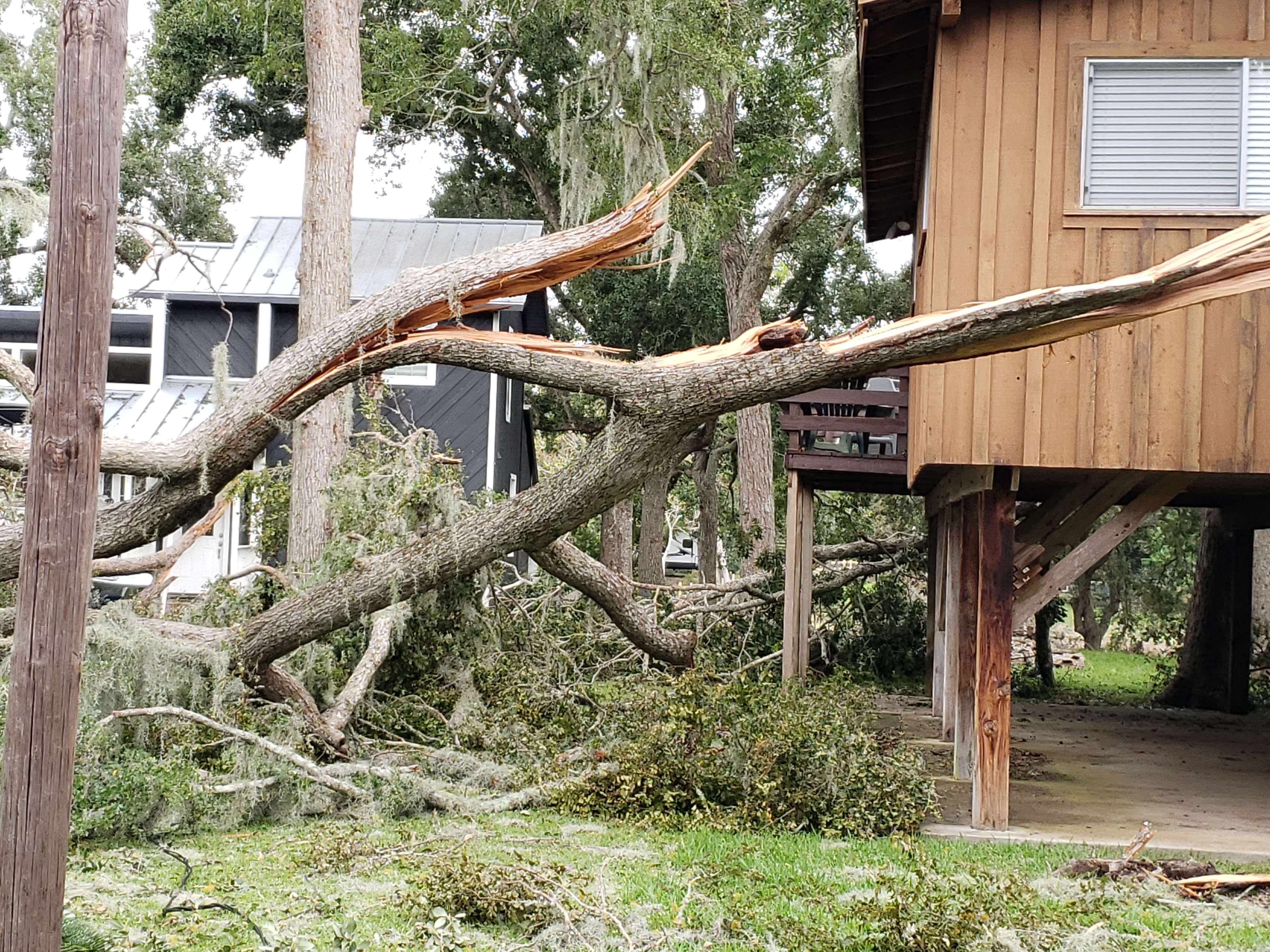
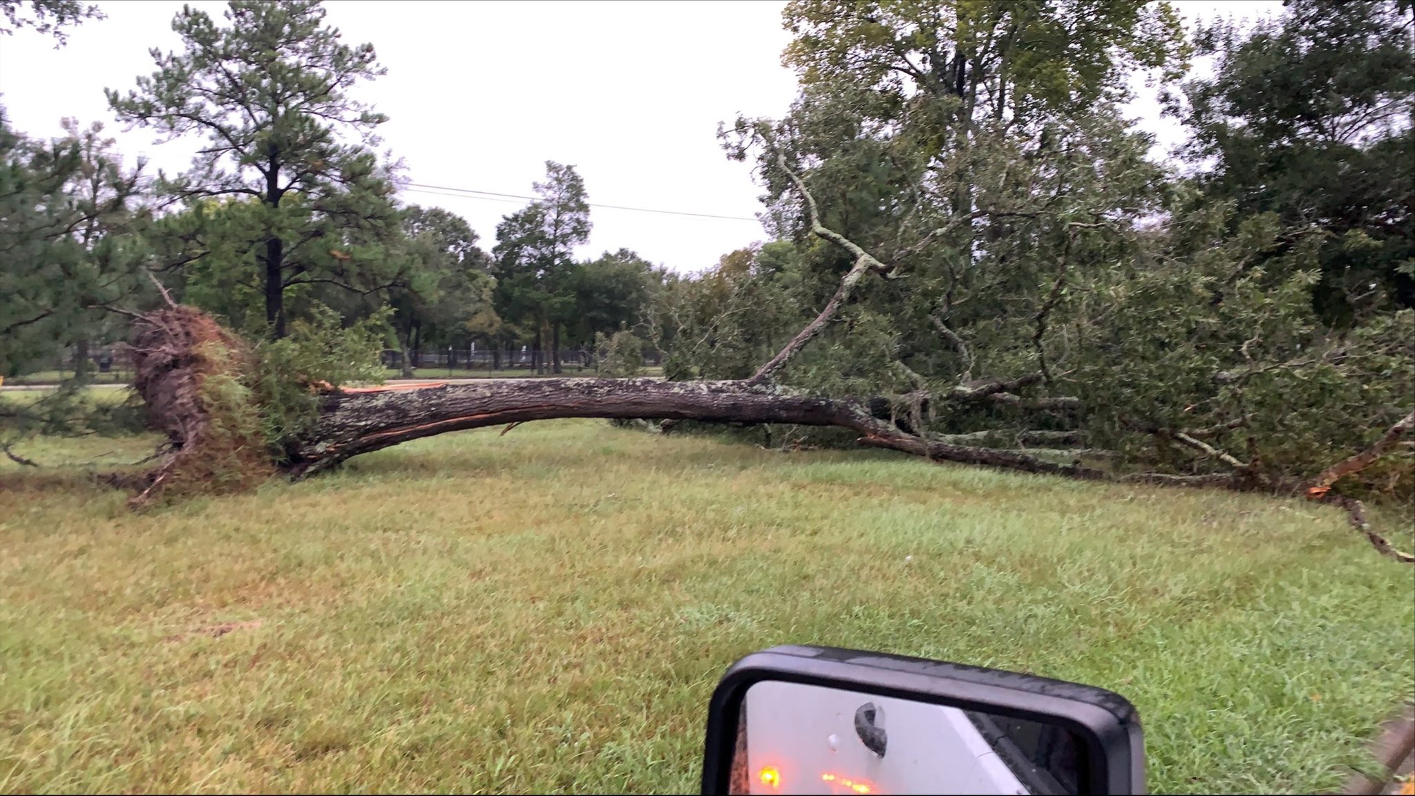
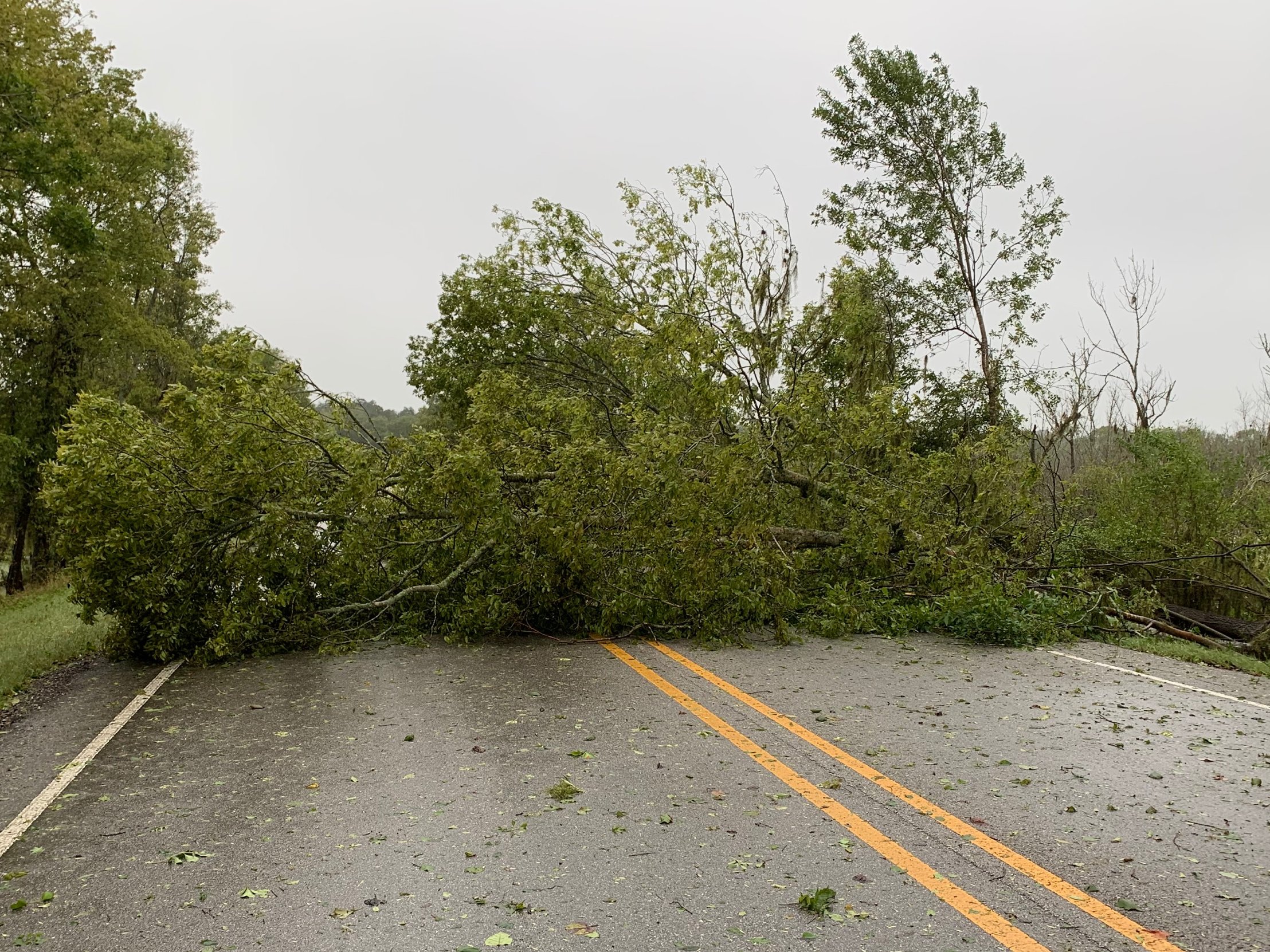
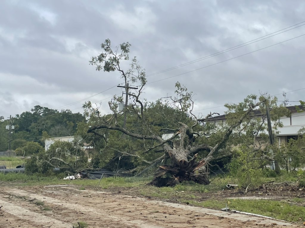
Numerous trees down between Sargent and Freeport. (Source: NWS Houston) |
Wind damage near Fort Bend County. (Source: Jack Acosta) |
Down tree near the Bay Area park, Houston. (Source: Harris County Precinct 2) |
 |
 |
 |
 |
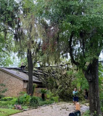
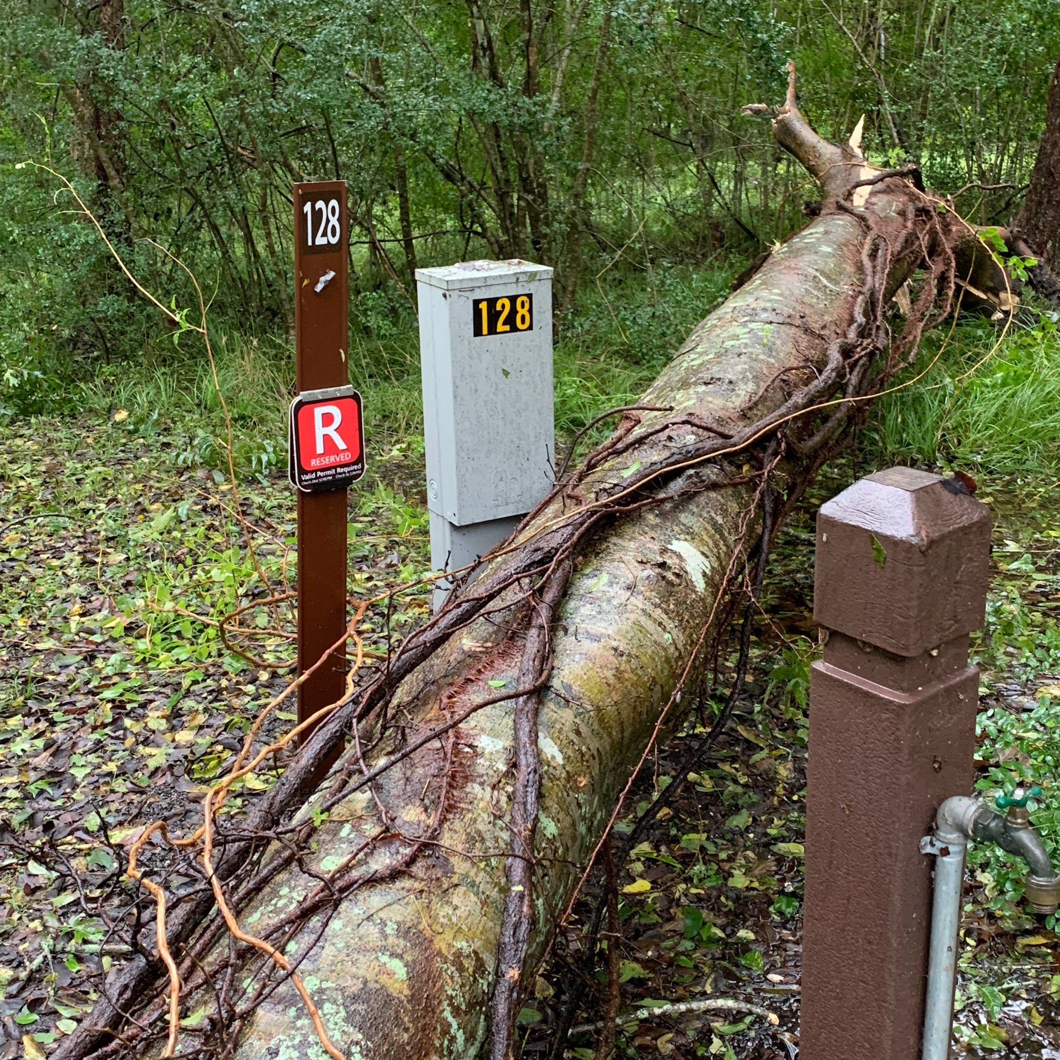
| Wind damage at Brazos Bend State Park near Houston. (Source: Texas Parks and Wildlife) |
Wind damage at Brazos Bend State Park near Houston. (Source: Texas Parks and Wildlife) |
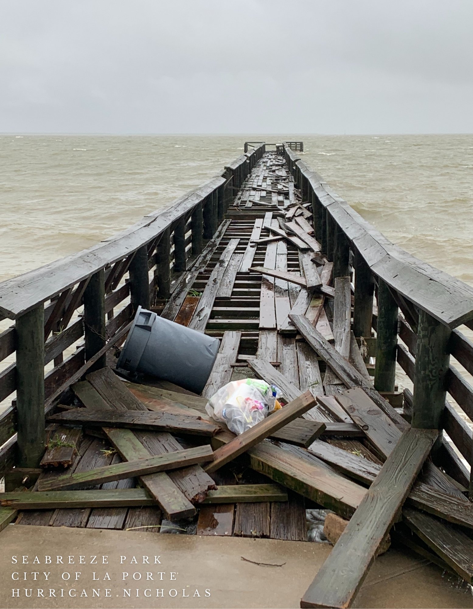
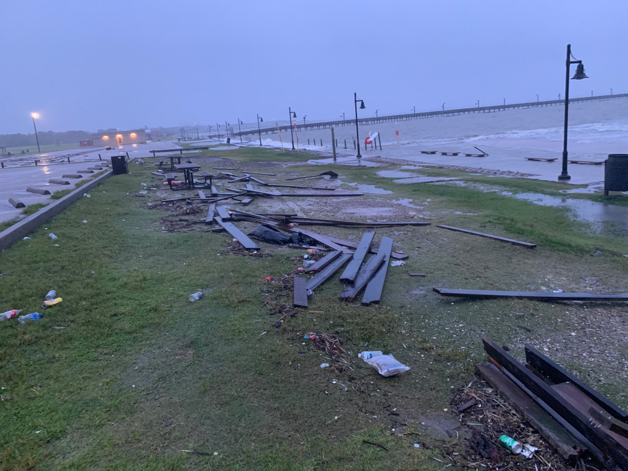
Damage at Seabreeze Park Pier in La Porte, TX due to winds and storm surge. (Source: La Porte Emergency Management (OEM)) |
Damage at Sylvan Beach due to strong winds and storm surge. (Source: La Porte Emergency Management (OEM)) |
 |
 |
 |
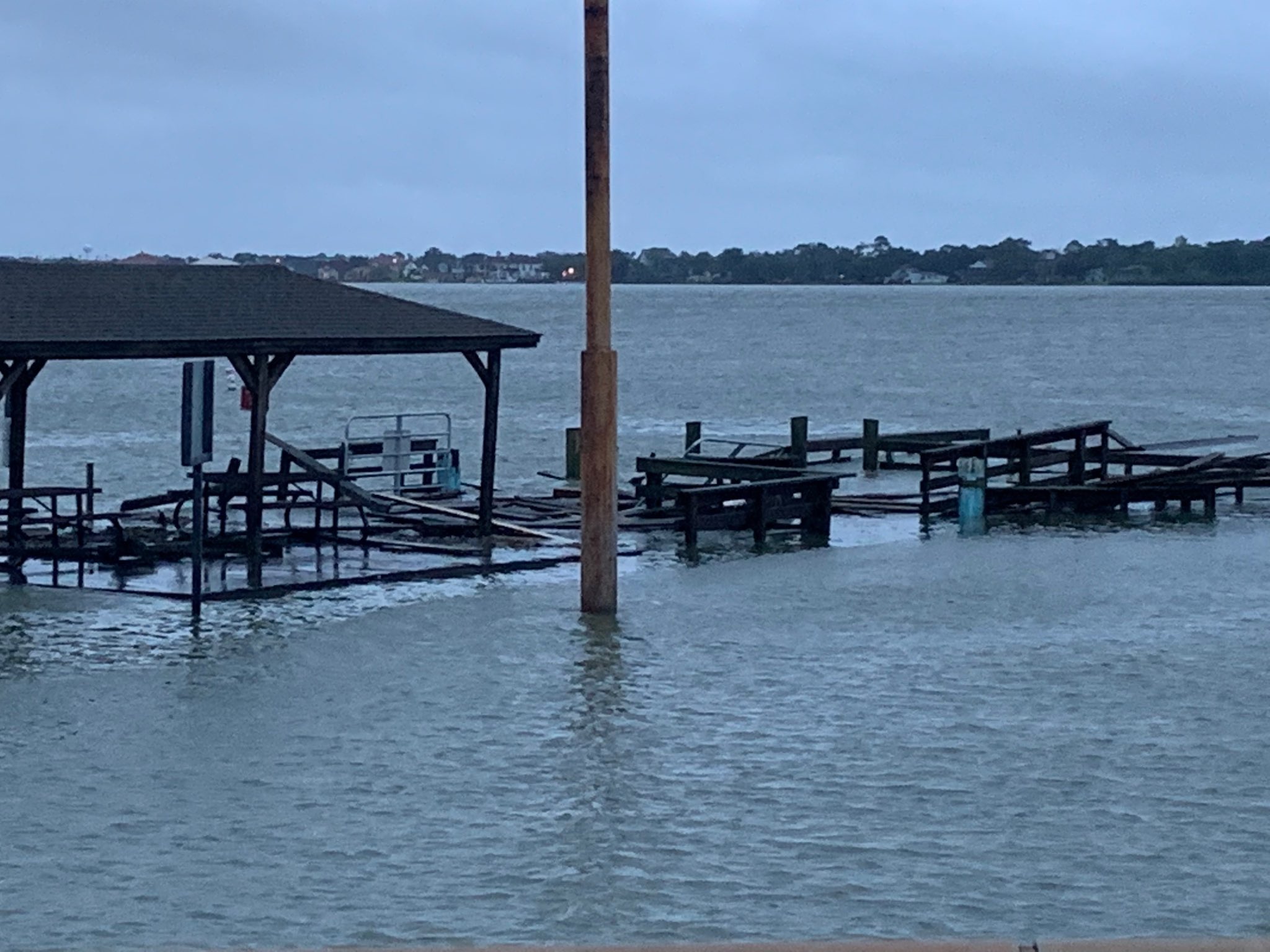
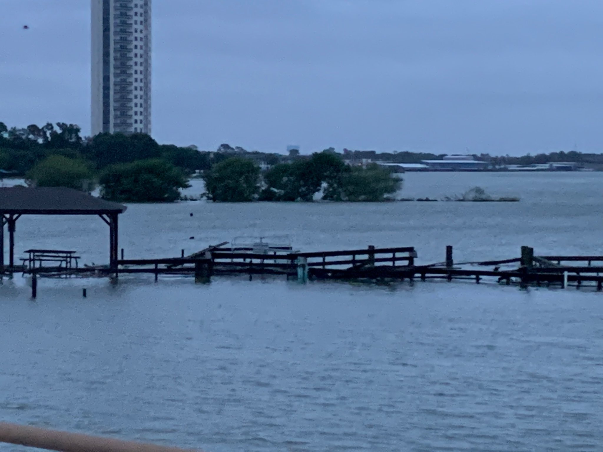
| Damage near Clear Lake Park boat ramp. (Source: Harris County Precinct 2) |
Damage near Clear Lake Park boat ramp. (Source: Harris County Precinct 2) |
Damage near High Island, TX (Source: Justin Aaron) |
Radar & Satellite
Radar
 |
 |
 |
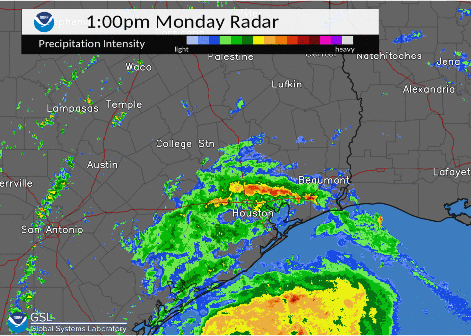
| 3-Day Radar Loop 09/12 at 11am through 09/15 at 3pm |
1-hr Radar Loop 09/14 at 1pm through 09/15 |
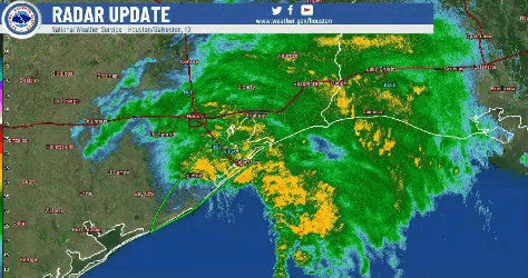
Radar Loop from 9/12 through 9/14 |
Satellite
 |
|
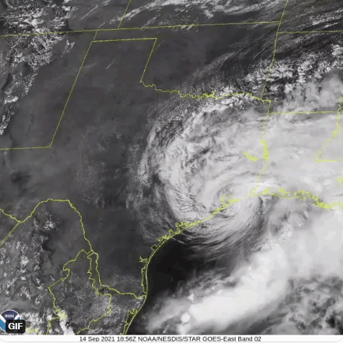 |
| GOES-15 infrared (band 10) showing Nicholas strengthening into a hurricane along the Texas coast. (Source: NOAA/CIRA) | GOES-East visible imagery showing Nicholas moving slowly across Southeast Texas. (Satellite loop taken on 9/14 at 1pm CDT) | GOES-East Band 2 imagery showing the center of Nicholas spinning near Galveston Bay around 2:30 pm on September 14th. |
Rain Reports
|
 |
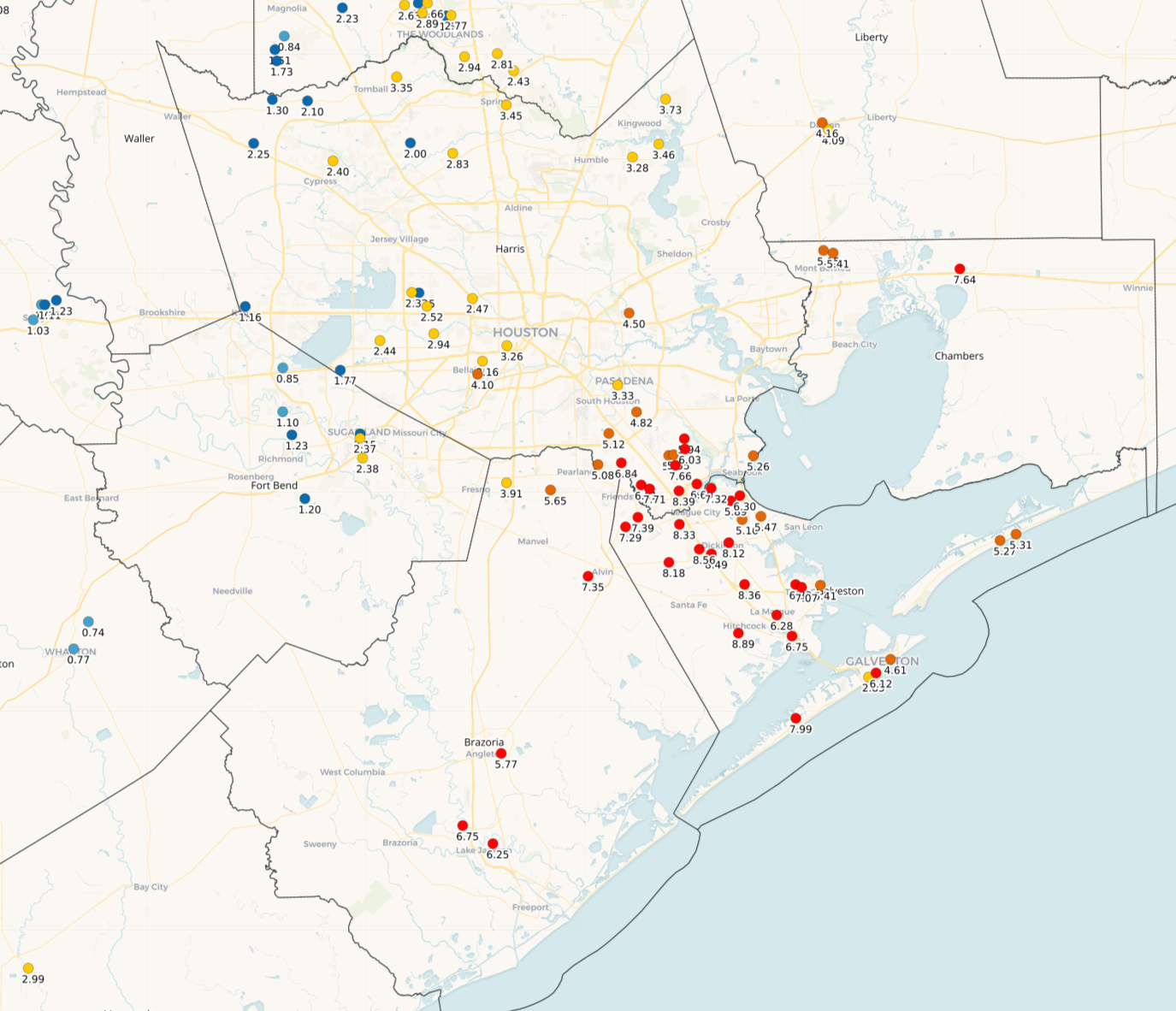 |
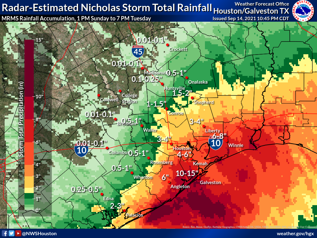
| A map of estimated rainfall totals from Hurricane Nicholas from MRMS. | A map of estimated rainfall totals from Hurricane Nicholas from MRMS, zoomed in on the area that saw the heaviest rains. | A map of CoCoRaHS reports of rainfall totals between 09/13/2021 to 09/15/2021. |
This is a preliminary list of rainfall reports received by WFO Houston/Galveston with Hurricane Nicholas. The collection of rainfall estimates will be refined in the days to come as an official report is compiled. In the meantime, please use caution with this preliminary data. A more detailed note on this data is provided at the bottom of the section.
...PRECIPITATION REPORTS PAST 72 HOURS... LOCATION AMOUNT TIME/DATE LAT/LON DEER PARK 9.85 IN 0152 PM 09/14 29.70N/95.12W HITCHCOCK 1.6 NNW 8.74 IN 0800 AM 09/14 29.34N/95.03W DICKINSON 1.4 W 8.46 IN 0801 AM 09/14 29.46N/95.09W SARGENT 1 ENE 8.16 IN 0740 PM 09/14 28.84N/95.66W 14.6 S SWEENY 8.14 IN 0400 AM 09/14 28.84N/95.66W SANTA FE 8.09 IN 0450 AM 09/14 29.38N/95.10W SARGENT 7.85 IN 0746 PM 09/14 28.81N/95.67W SANTA FE 7.83 IN 0750 PM 09/14 29.36N/95.13W LEAGUE CITY 7.68 IN 0745 PM 09/14 29.50N/95.10W 1.7 N LEAGUE CITY (HCFCD) 7.64 IN 0303 PM 09/14 29.51N/95.12W ANAHUAC 5.7 N 7.56 IN 0600 PM 09/14 29.85N/94.67W GALVESTON ROAD @ ALLENDALE 7.52 IN 0100 PM 09/14 29.68N/95.25W LEAGUE CITY 2.7 NE 7.19 IN 0800 AM 09/14 29.54N/95.07W ALVIN 1.6 SW 7.16 IN 0800 AM 09/14 29.42N/95.27W BRAZORIA NWR 7.10 IN 0728 PM 09/14 29.15N/95.30W SAN BERNARD NWR 6.94 IN 0729 PM 09/14 28.86N/95.57W 3.1 SE SAN LEON 6.86 IN 0730 PM 09/14 29.45N/94.92W 0.6 S TAYLOR LAKE VILLAGE (H 6.84 IN 0715 PM 09/14 29.57N/95.05W 2.0 SW FRIENDSWOOD (HCFCD) 6.81 IN 0306 PM 09/14 29.50N/95.22W LA MARQUE 3.9 SE 6.70 IN 0800 AM 09/14 29.33N/94.94W HOUSTON 6.69 IN 1100 AM 09/14 29.57N/95.15W 2.8 N NASSAU BAY (HCFCD) 6.68 IN 0719 PM 09/14 29.58N/95.10W LAKE JACKSON 2.3 NW 6.67 IN 0800 AM 09/14 29.07N/95.47W 1.0 SW TAYLOR LAKE VILLAGE ( 6.67 IN 0715 PM 09/14 29.57N/95.07W ANAHUAC 6.66 IN 0612 PM 09/14 29.67N/94.44W 2.5 E FRIENDSWOOD (HCFCD) 6.64 IN 0307 PM 09/14 29.50N/95.16W 1.2 E FRIENDSWOOD (HCFCD) 6.60 IN 0305 PM 09/14 29.52N/95.18W 1.6 E FREEPORT (R2) (R2) 6.50 IN 0700 PM 09/14 28.95N/95.34W RICHWOOD 6.45 IN 0750 PM 09/14 29.07N/95.42W EL LAGO 6.32 IN 0746 PM 09/14 29.56N/95.05W WEBSTER 6.23 IN 0750 PM 09/14 29.53N/95.12W LEAGUE CITY 6.14 IN 0745 PM 09/14 29.55N/95.06W 5.0 N FRIENDSWOOD (HCFCD) 6.12 IN 0309 PM 09/14 29.58N/95.19W 1.5 W FRIENDSWOOD (HCFCD) 6.08 IN 0528 PM 09/14 29.51N/95.22W MATAGORDA 1 S 6.04 IN 0740 PM 09/14 28.68N/95.97W 1.2 N LA PORTE (HCFCD) 5.96 IN 0358 PM 09/14 29.68N/95.05W 0.7 S NASSAU BAY (HCFCD) 5.88 IN 0311 PM 09/14 29.53N/95.09W 3.5 E BAYTOWN (HCFCD) 5.75 IN 0355 PM 09/14 29.77N/94.92W PEARLAND 5.71 IN 0653 PM 09/14 29.52N/95.25W PEARLAND 3.4 WSW 5.69 IN 0800 AM 09/14 29.54N/95.33W 1.5 SE LA PORTE (HCFCD) 5.52 IN 0358 PM 09/14 29.65N/95.03W MONT BELVIEU 1.3 NNE 5.47 IN 0600 PM 09/14 29.87N/94.87W SOUTH HOUSTON (HCFCD) 5.32 IN 0722 PM 09/14 29.66N/95.23W 3.0 SE PASADENA (HCFCD) 5.32 IN 0717 PM 09/14 29.63N/95.11W 2.4 NW BAYTOWN (HCFCD) 5.28 IN 0739 PM 09/14 29.77N/95.00W IOWA COLONY 5.25 IN 0746 PM 09/14 29.44N/95.45W 1.3 E PEARLAND (HCFCD) 5.24 IN 0310 PM 09/14 29.55N/95.25W 2.5 NW FRIENDSWOOD (HCFCD) 5.19 IN 0302 PM 09/14 29.54N/95.22W CRYSTAL BEACH 2.2 ENE 5.15 IN 0800 AM 09/14 29.47N/94.61W 1.4 NW SOUTH HOUSTON (HCFCD) 5.12 IN 0722 PM 09/14 29.68N/95.24W 4.1 NE PEARLAND (HCFCD) 5.11 IN 0310 PM 09/14 29.59N/95.22W 2.6 N MORGANS POINT (RR) 5.08 IN 0740 PM 09/14 29.71N/95.00W 1.2 W SHOREACRES (HCFCD) 5.07 IN 0356 PM 09/14 29.62N/95.02W HOUSTON 5.01 IN 0745 PM 09/14 29.61N/95.18W 2.5 NW PASADENA (HCFCD) 4.80 IN 0718 PM 09/14 29.68N/95.18W 2.1 N FRIENDSWOOD (HCFCD) 4.79 IN 0308 PM 09/14 29.54N/95.20W GALVESTON 4.70 IN 0752 PM 09/14 29.27N/94.87W HOUSTON 4.65 IN 0747 PM 09/14 29.58N/95.23W SAN LEON 4.64 IN 0745 PM 09/14 29.50N/94.95W 9.7 SW JONES CREEK 4.60 IN 0729 PM 09/14 28.86N/95.57W 1.7 NW HIGHLANDS (HCFCD) 4.56 IN 0400 PM 09/14 29.83N/95.08W GALVESTON 8.3 NE 4.51 IN 1100 AM 09/14 29.30N/94.78W MONT BELVIEU 1.5 NNW 4.50 IN 0800 AM 09/14 29.87N/94.89W 1.2 E BROOKSIDE VILLAGE (HCF 4.48 IN 0312 PM 09/14 29.60N/95.30W 2.1 SW LA PORTE (HCFCD) 4.44 IN 0718 PM 09/14 29.65N/95.08W 3.3 SE GALENA PARK (RR) (R 4.40 IN 0710 PM 09/14 29.71N/95.20W 3.4 SE GALENA PARK (HCFCD) 4.36 IN 0630 PM 09/14 29.71N/95.20W 2.2 W CLOVERLEAF (HCFCD) 4.24 IN 0741 PM 09/14 29.78N/95.21W 3.2 SW SPRING (HCFCD) 4.12 IN 0719 PM 09/14 30.04N/95.43W 1.8 SE CLOVERLEAF (HCFCD) 4.08 IN 0735 PM 09/14 29.77N/95.15W 3.2 W JACINTO CITY (HCFCD) 4.08 IN 0727 PM 09/14 29.75N/95.29W 1.7 E CLOVERLEAF (RR) (RR) 4.04 IN 0740 PM 09/14 29.79N/95.14W 5.5 NW CLOVERLEAF (HCFCD) 4.00 IN 0721 PM 09/14 29.85N/95.23W 4.2 W BROOKSIDE VILLAGE (HCF 3.96 IN 0314 PM 09/14 29.59N/95.39W SANTA FE 3.95 IN 0750 PM 09/14 29.38N/95.10W HOUSTON HOBBY 3.92 IN 0714 PM 09/14 29.63N/95.28W 4.7 SE HOUSTON (RR) (RR) 3.88 IN 0730 PM 09/14 29.71N/95.35W 1.2 E WEST COLUMBIA 3.88 IN 0800 AM 09/14 29.14N/95.63W 2.5 SW SPRING (HCFCD) 3.88 IN 0718 PM 09/14 30.04N/95.42W 1.9 W BARRETT (HCFCD) 3.88 IN 0300 PM 09/14 29.88N/95.09W 1.9 W CROSBY (HCFCD) 3.85 IN 0357 PM 09/14 29.91N/95.09W PEARLAND 7.4 W 3.84 IN 0800 AM 09/14 29.55N/95.40W 1.8 NE CLOVERLEAF (HCFCD) 3.84 IN 0737 PM 09/14 29.81N/95.16W 2.8 S DEER PARK (HCFCD) 3.84 IN 0721 PM 09/14 29.65N/95.11W 7.2 NE PALACIOS (DATAWISE) 3.82 IN 1128 AM 09/14 28.79N/96.15W 4.0 N BROOKSIDE VILLAGE (HCF 3.80 IN 0724 PM 09/14 29.65N/95.34W 2.4 E WEST UNIVERSITY PLACE 3.76 IN 0727 PM 09/14 29.71N/95.39W 5.3 E KINGWOOD (HCFCD) 3.68 IN 0359 PM 09/14 30.07N/95.10W 2 ESE PASADENA 3.65 IN 0750 PM 09/14 29.65N/95.11W 1.0 W FREEPORT (RR) (RR) 3.60 IN 0745 PM 09/14 28.95N/95.38W 4.5 W GALENA PARK (HCFCD) 3.60 IN 0733 PM 09/14 29.72N/95.31W 5.8 SE SOUTHSIDE PLACE (RR) 3.56 IN 0730 PM 09/14 29.63N/95.39W 2.8 E HILSHIRE VILLAGE (RR) 3.56 IN 0715 PM 09/14 29.78N/95.44W KINGWOOD 3.1 ENE 3.56 IN 0915 AM 09/14 30.08N/95.14W 3.9 SE SPRING (HCFCD) 3.56 IN 0717 PM 09/14 30.03N/95.33W FRIENDSWOOD 0.4 W 3.51 IN 0900 AM 09/14 29.51N/95.20W 2.9 E HILSHIRE VILLAGE (HCFC 3.51 IN 0643 PM 09/14 29.78N/95.44W WEBSTER 3.50 IN 0749 PM 09/14 29.54N/95.11W 6.0 NE CROSBY (HCFCD) 3.48 IN 0357 PM 09/14 29.97N/94.99W 1.5 E HOUSTON (HCFCD) 3.44 IN 0313 PM 09/14 29.77N/95.36W 2.5 NW JACINTO CITY (HCFCD) 3.44 IN 0306 PM 09/14 29.79N/95.27W DAYTON 3.44 IN 0722 PM 09/14 30.11N/94.93W 2.2 SW SHELDON (RR) (RR) 3.40 IN 0740 PM 09/14 29.84N/95.16W 0.9 NE JACINTO CITY (HCFCD) 3.40 IN 0714 PM 09/14 29.77N/95.23W 5.2 NW JACINTO CITY (HCFCD) 3.40 IN 0736 PM 09/14 29.81N/95.31W 2.1 S HUMBLE (HCFCD) 3.39 IN 0347 PM 09/14 29.97N/95.27W 1.3 S SOUTHSIDE PLACE (HCFCD 3.39 IN 0730 PM 09/14 29.69N/95.44W 2.2 SW SHELDON (HCFCD) 3.36 IN 0737 PM 09/14 29.84N/95.16W 2.7 S BELLAIRE (HCFCD) 3.33 IN 0732 PM 09/14 29.66N/95.46W 4.2 E ALDINE (HCFCD) 3.31 IN 0744 PM 09/14 29.92N/95.31W 4.9 N JACINTO CITY (RR) (R 3.24 IN 0745 PM 09/14 29.84N/95.23W SPRING 3.24 IN 0746 PM 09/14 30.09N/95.36W 5.2 NW BROOKSIDE VILLAGE (HC 3.24 IN 0726 PM 09/14 29.63N/95.39W BAYTOWN 3.23 IN 0747 PM 09/14 29.80N/94.91W HOUSTON 3.20 IN 0746 PM 09/14 29.78N/95.37W 4.6 SE HUMBLE (RR) (RR) ( 3.20 IN 0745 PM 09/14 29.93N/95.23W 7.3 S HUMBLE (HCFCD) 3.20 IN 0741 PM 09/14 29.89N/95.24W HOUSTON INTNL 3.18 IN 0718 PM 09/14 30.00N/95.37W PORTER 3.17 IN 0727 PM 09/14 30.07N/95.25W 5.0 N JACINTO CITY (HCFCD) 3.16 IN 0743 PM 09/14 29.84N/95.23W 1.8 S BELLAIRE (HCFCD) 3.16 IN 0732 PM 09/14 29.68N/95.47W 2.4 N SOUTH HOUSTON (HCFCD) 3.16 IN 0639 PM 09/14 29.69N/95.22W 1.5 S WEBSTER (RR) (RR) ( 3.12 IN 0745 PM 09/14 29.51N/95.12W 6.3 NW JACINTO CITY (HCFCD) 3.12 IN 0351 PM 09/14 29.85N/95.28W 2.0 NE HOUSTON (HCFCD) 3.12 IN 0350 PM 09/14 29.79N/95.37W WEBSTER 3.11 IN 0750 PM 09/14 29.53N/95.12W 4.3 SE ALDINE (HCFCD) 3.09 IN 0714 PM 09/14 29.86N/95.33W 1.2 E ALDINE (HCFCD) 3.09 IN 0355 PM 09/14 29.91N/95.36W 4.6 SE HUMBLE (HCFCD) 3.08 IN 0743 PM 09/14 29.93N/95.23W 2.0 SE SOUTHSIDE PLACE (HCFC 3.08 IN 0312 PM 09/14 29.69N/95.41W 2.8 NE TOMBALL (HCFCD) 3.05 IN 0312 PM 09/14 30.13N/95.60W 0.9 SE PINEY POINT VILLAGE ( 3.04 IN 0717 PM 09/14 29.75N/95.51W 3.2 W THE WOODLANDS (HCFCD) 3.04 IN 0627 PM 09/14 30.17N/95.54W PALACIOS 11.5 NNE 2.98 IN 0800 AM 09/14 28.87N/96.17W LEAGUE CITY 2.97 IN 0749 PM 09/14 29.49N/95.13W 3.3 S OAK RIDGE NORTH (HCFCD 2.97 IN 0314 PM 09/14 30.11N/95.44W 2.5 SE HOUSTON (RR) (RR) 2.96 IN 0740 PM 09/14 29.73N/95.37W 3.1 SE ROMAN FOREST (HCFCD) 2.96 IN 0304 PM 09/14 30.15N/95.12W 2 SSW HOUSTON 2.94 IN 0750 PM 09/14 29.74N/95.39W 2 NNE HOUSTON 2.94 IN 0750 PM 09/14 29.80N/95.37W 6.3 SE CUT AND SHOOT (RR) 2.92 IN 0745 PM 09/14 30.26N/95.30W 5.0 N FRIENDSWOOD (RR) (RR 2.92 IN 0745 PM 09/14 29.58N/95.19W 3.2 SW SPRING (RR) (RR) ( 2.92 IN 0700 PM 09/14 30.04N/95.43W HOUSTON 2.92 IN 0745 PM 09/14 29.79N/95.39W 1.4 W HOUSTON (HCFCD) 2.92 IN 0715 PM 09/14 29.76N/95.41W CONROE 3.7 S 2.90 IN 0800 AM 09/14 30.27N/95.48W 2.6 E HILSHIRE VILLAGE (RR) 2.88 IN 0745 PM 09/14 29.80N/95.45W 1.9 SE SOUTHSIDE PLACE (RR) 2.88 IN 0715 PM 09/14 29.69N/95.41W SANTA MARIA 2.88 IN 0746 PM 09/14 30.17N/95.60W 3.5 NW HOUSTON (HCFCD) 2.88 IN 0744 PM 09/14 29.80N/95.43W 2.3 NE ALDINE (HCFCD) 2.88 IN 0345 PM 09/14 29.94N/95.35W 6.1 W SPRING (HCFCD) 2.88 IN 0720 PM 09/14 30.02N/95.48W 4.2 E TOMBALL (HCFCD) 2.88 IN 0734 PM 09/14 30.11N/95.55W 4 NNE FRESNO 2.87 IN 0750 PM 09/14 29.60N/95.42W HOUSTON 2.85 IN 0747 PM 09/14 29.95N/95.58W 6.3 NW JERSEY VILLAGE (HCFCD 2.84 IN 0725 PM 09/14 29.96N/95.63W 7.2 NW JERSEY VILLAGE (HCFCD 2.84 IN 0731 PM 09/14 29.98N/95.63W 8.8 NE JERSEY VILLAGE (HCFCD 2.84 IN 0721 PM 09/14 30.01N/95.51W CROSBY 2.81 IN 0846 AM 09/14 29.95N/95.11W 2.2 S KINGWOOD (HCFCD) 2.80 IN 0302 PM 09/14 30.03N/95.20W CONROE 2.78 IN 0703 PM 09/14 30.24N/95.48W 6.2 N JERSEY VILLAGE (HCFCD) 2.77 IN 0723 PM 09/14 29.97N/95.60W 3.6 NE HILSHIRE VILLAGE (RR 2.76 IN 0745 PM 09/14 29.83N/95.45W 4.9 S ALDINE (HCFCD) 2.76 IN 0654 PM 09/14 29.85N/95.40W 4.0 NE STAFFORD (HCFCD) 2.75 IN 0734 PM 09/14 29.67N/95.53W 4 S KATY 2.74 IN 0745 PM 09/14 29.73N/95.83W THE WOODLANDS 2.9 N 2.74 IN 0830 AM 09/14 30.20N/95.49W 4.1 N MEADOWS (RR) (RR) ( 2.72 IN 0740 PM 09/14 29.71N/95.59W SPLENDORA (RR) (RR) (RR) 2.72 IN 0740 PM 09/14 30.23N/95.17W 1.6 SE SOUTHSIDE PLACE (HCFC 2.68 IN 0729 PM 09/14 29.70N/95.41W 6.6 N HILSHIRE VILLAGE (HCFC 2.68 IN 0625 PM 09/14 29.88N/95.47W 1.9 SW ALDINE (HCFCD) 2.65 IN 0353 PM 09/14 29.89N/95.40W 4.0 N MEADOWS (HCFCD) 2.64 IN 0736 PM 09/14 29.71N/95.58W 5.5 N HILSHIRE VILLAGE (HCFC 2.64 IN 0354 PM 09/14 29.87N/95.47W 4.2 NE HILSHIRE VILLAGE (HCF 2.64 IN 0352 PM 09/14 29.85N/95.46W 3.9 NE HILSHIRE VILLAGE (HCF 2.64 IN 0744 PM 09/14 29.84N/95.46W 14.6 S SWEENY 2.62 IN 0700 PM 09/14 28.84N/95.66W 1 SSE SOUTHSIDE PLACE 2.62 IN 0750 PM 09/14 29.69N/95.43W 1 NW WEBSTER 2.61 IN 0745 PM 09/14 29.55N/95.14W 2.8 NE HILSHIRE VILLAGE (HCF 2.60 IN 0609 PM 09/14 29.83N/95.47W 0.6 NE SPRING VALLEY (HCFCD) 2.60 IN 0716 PM 09/14 29.80N/95.50W HOUSTON 2.57 IN 0745 PM 09/14 29.59N/95.11W HOUSTON 2.54 IN 0746 PM 09/14 29.55N/95.08W 3.2 W THE WOODLANDS (RR) ( 2.52 IN 0715 PM 09/14 30.17N/95.54W 2.5 NE HOUSTON (RR) (RR) 2.52 IN 0600 PM 09/14 29.80N/95.37W 6.7 N JERSEY VILLAGE (HCFCD) 2.52 IN 0722 PM 09/14 29.99N/95.57W BUNKER HILL VILLAGE 2.7 WNW 2.50 IN 0800 AM 09/14 29.78N/95.57W CONROE 2.1 SSW 2.50 IN 0900 AM 09/14 30.29N/95.48W LEAGUE CITY 2.50 IN 0750 PM 09/14 29.48N/95.15W 1 NNW HOUSTON 2.50 IN 0750 PM 09/14 29.79N/95.40W 1.5 NW LIBERTY 2.49 IN 0731 PM 09/14 30.06N/94.82W 4.0 W JERSEY VILLAGE (HCFCD) 2.49 IN 0304 PM 09/14 29.88N/95.63W 3.3 NE MEADOWS (RR) (RR) 2.48 IN 0740 PM 09/14 29.69N/95.55W 1.5 W FRIENDSWOOD (RR) (RR 2.48 IN 0725 PM 09/14 29.51N/95.22W 4.3 NE HOUSTON (RR) (RR) 2.48 IN 0600 PM 09/14 29.81N/95.33W DAMON 1 NNW 2.48 IN 0715 PM 09/14 29.30N/95.74W HOUSTON 2.44 IN 0745 PM 09/14 29.58N/95.12W 3.5 NE MEADOWS (HCFCD) 2.44 IN 0734 PM 09/14 29.70N/95.56W 2.5 W BUNKER HILL VILLAGE (H 2.44 IN 0719 PM 09/14 29.78N/95.57W NASSAU BAY 2.41 IN 0750 PM 09/14 29.55N/95.10W 3.8 NW ALDINE (HCFCD) 2.40 IN 0347 PM 09/14 29.96N/95.42W SUGAR LAND 2.6 SSW 2.36 IN 0900 AM 09/14 29.58N/95.63W SUGAR LAND .5 SE 2.34 IN 0845 AM 09/14 29.61N/95.63W WEBSTER 2.34 IN 0745 PM 09/14 29.54N/95.10W PASADENA 2.33 IN 0749 PM 09/14 29.60N/95.11W 2.3 NW JERSEY VILLAGE (HCFCD 2.33 IN 0348 PM 09/14 29.92N/95.58W SOUTH HOUSTON (RR) (RR) ( 2.32 IN 0725 PM 09/14 29.66N/95.23W HOUSTON 2.32 IN 0746 PM 09/14 29.64N/95.13W 6.7 SE DANBURY 2.32 IN 0728 PM 09/14 29.14N/95.29W 2.1 NW BAYOU VISTA (R2) (R 2.32 IN 0730 PM 09/14 29.35N/94.96W 1 N BELLAIRE 2.32 IN 0750 PM 09/14 29.72N/95.46W CLEVELAND 5.0 S 2.30 IN 0800 AM 09/14 30.27N/95.07W CLEVELAND 5.0 S 2.30 IN 1200 PM 09/14 30.27N/95.07W HOUSTON 2.29 IN 0748 PM 09/14 29.71N/95.59W 1.1 SW TAYLOR LAKE VILLAGE 2.28 IN 0730 PM 09/14 29.57N/95.07W 1.2 E FRIENDSWOOD (RR) (RR 2.28 IN 0715 PM 09/14 29.52N/95.18W 3.8 N MEADOWS (HCFCD) 2.28 IN 0737 PM 09/14 29.70N/95.57W LAKE CREEK AT EGYPT 2.28 IN 0155 PM 09/14 30.25N/95.58W 5.6 N HILSHIRE VILLAGE (HCFC 2.28 IN 0346 PM 09/14 29.87N/95.48W 1 NE LEAGUE CITY 2.26 IN 0750 PM 09/14 29.50N/95.10W 1.9 W SHENANDOAH 2.26 IN 0700 PM 09/14 30.19N/95.48W 2.2 SW SUGAR LAND (RR) (RR 2.24 IN 0715 PM 09/14 29.60N/95.64W 5.5 N HILSHIRE VILLAGE (RR) 2.24 IN 0640 PM 09/14 29.87N/95.47W SPRING 2.23 IN 0748 PM 09/14 30.07N/95.41W CYPRESS 2.21 IN 0749 PM 09/14 29.95N/95.71W 8.1 NW JERSEY VILLAGE (HCFCD 2.20 IN 0727 PM 09/14 29.96N/95.68W 0.6 S JERSEY VILLAGE (RR) 2.16 IN 0740 PM 09/14 29.88N/95.57W 4.5 W BUNKER HILL VILLAGE (H 2.16 IN 0719 PM 09/14 29.76N/95.61W 2.7 E JERSEY VILLAGE (HCFCD) 2.16 IN 0346 PM 09/14 29.88N/95.52W 0.7 E JERSEY VILLAGE (HCFCD) 2.16 IN 0348 PM 09/14 29.89N/95.56W 2 WSW SANTA FE 2.15 IN 0745 PM 09/14 29.36N/95.13W 1 WNW DEER PARK 2.14 IN 0745 PM 09/14 29.69N/95.13W COLORADO RIVER AT BAY CITY 2.13 IN 0740 PM 09/14 28.97N/96.01W 7.0 W MARKHAM (DATAWISE) 2.13 IN 1107 AM 09/14 28.93N/96.17W 5.1 NE JERSEY VILLAGE (HCFCD 2.12 IN 0350 PM 09/14 29.95N/95.52W GALVESTON 2.11 IN 0750 PM 09/14 29.20N/94.93W 2.3 NW TOMBALL (HCFCD) 2.11 IN 0716 PM 09/14 30.12N/95.65W SPRING 2.10 IN 0748 PM 09/14 30.21N/95.56W KATY 2.10 IN 0731 PM 09/14 29.84N/95.68W 2.6 NW HEDWIG VILLAGE (RR) 2.08 IN 0700 PM 09/14 29.80N/95.55W 5.9 NE JERSEY VILLAGE (HCFCD 2.08 IN 0349 PM 09/14 29.95N/95.50W BAY CITY 2.04 IN 0735 PM 09/14 28.97N/95.87W CONROE 0.7 E 1.99 IN 0800 AM 09/14 30.32N/95.46W ALVIN 1.99 IN 0747 PM 09/14 29.48N/95.24W 5 N FRESNO 1.93 IN 0750 PM 09/14 29.62N/95.45W 3 NE TOWN WEST 1.93 IN 0750 PM 09/14 29.71N/95.60W 7.4 SW TOMBALL (HCFCD) 1.92 IN 0732 PM 09/14 30.02N/95.70W CONROE 1.91 IN 0730 PM 09/14 30.35N/95.42W ANAHUAC 1.90 IN 0750 PM 09/14 29.76N/94.67W WEST COLUMBIA 1.89 IN 0749 PM 09/14 29.13N/95.65W GALVESTON 1.89 IN 0748 PM 09/14 29.20N/94.94W 1 SE LA PORTE 1.88 IN 0750 PM 09/14 29.65N/95.03W 1.3 NW HOUSTON (RR) (RR) 1.88 IN 0745 PM 09/14 29.78N/95.40W 0.8 NW HOUSTON (HCFCD) 1.88 IN 0742 PM 09/14 29.78N/95.40W HALLS BAYOU (RR) (RR) (RR 1.84 IN 0740 PM 09/14 29.88N/95.40W 1.8 N FRIENDSWOOD (RR) (RR 1.84 IN 0745 PM 09/14 29.54N/95.20W 7.7 E WALLER (HCFCD) 1.84 IN 0733 PM 09/14 30.03N/95.80W 1 SSW PASADENA 1.83 IN 0749 PM 09/14 29.63N/95.16W CYPRESS 1.82 IN 0747 PM 09/14 29.95N/95.73W MIDFIELD 1.82 IN 0740 PM 09/14 28.94N/96.21W 2.2 NE MISSION BEND (RR) ( 1.80 IN 0740 PM 09/14 29.72N/95.64W 2.8 NE HILSHIRE VILLAGE (RR 1.80 IN 0700 PM 09/14 29.83N/95.47W 1.9 NE MISSION BEND (HCFCD) 1.80 IN 0738 PM 09/14 29.72N/95.64W MONTGOMERY 1.79 IN 0745 PM 09/14 30.30N/95.63W TAYLOR LAKE VILLAGE 1.79 IN 0750 PM 09/14 29.58N/95.06W 1 SSE TEXAS CITY 1.78 IN 0750 PM 09/14 29.39N/94.95W SUGAR LAND 1.78 IN 0746 PM 09/14 29.54N/95.67W 3.3 NW TAYLOR LAKE VILLAGE 1.76 IN 0730 PM 09/14 29.61N/95.08W 0.6 NW PASADENA (RR) (RR) 1.76 IN 0720 PM 09/14 29.67N/95.16W 4.5 W GALENA PARK (RR) (RR 1.76 IN 0735 PM 09/14 29.72N/95.30W 6.2 NE KATY (HCFCD) 1.76 IN 0310 PM 09/14 29.88N/95.77W 7.7 W JERSEY VILLAGE (HCFCD) 1.76 IN 0306 PM 09/14 29.90N/95.70W LA WARD 1.75 IN 0745 PM 09/14 28.77N/96.45W 3 NE SOUTH HOUSTON 1.75 IN 0750 PM 09/14 29.70N/95.20W COLDSPRINGS 1.74 IN 0702 PM 09/14 30.52N/95.09W 4.3 NE HOUSTON (RR) (RR) 1.72 IN 0745 PM 09/14 29.81N/95.33W 7 ENE CUT AND SHOOT 1.72 IN 0745 PM 09/14 30.37N/95.24W 8.5 N KATY (RR) (RR) (RR) 1.72 IN 0730 PM 09/14 29.92N/95.84W 8.1 SW JERSEY VILLAGE (HCFCD 1.72 IN 0307 PM 09/14 29.83N/95.69W 2.9 W BAY CITY 1.70 IN 0700 PM 09/14 28.97N/96.01W MORGANS POINT 1.69 IN 0745 PM 09/14 29.68N/95.01W FRIENDSWOOD 1.68 IN 0745 PM 09/14 29.55N/95.18W 3.8 W SOUTH HOUSTON (RR) ( 1.68 IN 0730 PM 09/14 29.67N/95.29W 3.4 E KATY (RR) (RR) (RR) 1.68 IN 0710 PM 09/14 29.80N/95.77W 5.2 E WALLER (HCFCD) 1.68 IN 0716 PM 09/14 30.09N/95.84W 1 E FREEPORT 1.67 IN 0750 PM 09/14 28.95N/95.34W MONTGOMERY 0.4 N 1.65 IN 0800 AM 09/14 30.40N/95.70W MAGNOLIA 5.3 SSW 1.61 IN 0800 AM 09/14 30.14N/95.77W 6.3 NW MISSION BEND (HCFCD) 1.57 IN 0301 PM 09/14 29.77N/95.73W 7.8 N MISSION BEND (HCFCD) 1.57 IN 0307 PM 09/14 29.80N/95.70W 2.5 SW SPRING (RR) (RR) ( 1.56 IN 0750 PM 09/14 30.04N/95.41W 5.5 NW CLOVERLEAF (RR) (RR 1.56 IN 0725 PM 09/14 29.85N/95.23W 1.1 NW MEADOWS (RR) (RR) 1.56 IN 0745 PM 09/14 29.67N/95.59W 1.1 NW MEADOWS (HCFCD) 1.56 IN 0740 PM 09/14 29.67N/95.60W WILLIS 1.55 IN 0745 PM 09/14 30.42N/95.55W 3.2 NW WOODLOCH 1.53 IN 0715 PM 09/14 30.24N/95.46W 1.5 SW HUMBLE (RR) (RR) ( 1.52 IN 0750 PM 09/14 29.98N/95.28W 2.5 SE HOUSTON (RR) (RR) 1.52 IN 0740 PM 09/14 29.74N/95.36W 4.1 W BROOKSIDE VILLAGE (RR 1.52 IN 0750 PM 09/14 29.59N/95.38W FRANCITAS 1.50 IN 0747 PM 09/14 28.86N/96.34W HUNTERS CREEK VILLAGE 1.49 IN 0750 PM 09/14 29.77N/95.49W 6.3 NW JACINTO CITY (RR) ( 1.48 IN 0735 PM 09/14 29.85N/95.28W CYPRESS 1.48 IN 0747 PM 09/14 29.98N/95.71W MANVEL 1.47 IN 0746 PM 09/14 29.52N/95.38W HOUSTON 1.46 IN 0748 PM 09/14 29.77N/95.51W DEER PARK 1.46 IN 0747 PM 09/14 29.69N/95.14W PALACIOS 1.45 IN 0653 PM 09/14 28.72N/96.25W 5 NE HILSHIRE VILLAGE 1.45 IN 0745 PM 09/14 29.84N/95.42W HOUSTON 1.44 IN 0747 PM 09/14 29.74N/95.39W 1 SW KEMAH 1.42 IN 0749 PM 09/14 29.52N/95.04W HUMBLE 1.42 IN 0749 PM 09/14 30.00N/95.17W 2.3 SE HOUSTON (RR) (RR) 1.40 IN 0725 PM 09/14 29.74N/95.37W 1.3 W BARRETT (RR) (RR) ( 1.40 IN 0750 PM 09/14 29.88N/95.08W 2.4 S TOMBALL (RR) (RR) ( 1.40 IN 0740 PM 09/14 30.06N/95.62W HUMBLE 1.39 IN 0740 PM 09/14 29.93N/95.19W 2 NE SOUTH HOUSTON 1.38 IN 0750 PM 09/14 29.69N/95.19W 2.4 S TOMBALL (HCFCD) 1.36 IN 0735 PM 09/14 30.06N/95.62W SHOREACRES 1.34 IN 0750 PM 09/14 29.61N/95.01W 4 ESE HOUSTON 1.34 IN 0750 PM 09/14 29.74N/95.33W SPRING 1.34 IN 0749 PM 09/14 30.05N/95.44W 2 NNW PASADENA 1.33 IN 0750 PM 09/14 29.69N/95.17W 1.9 W FIRST COLONY (RR) (R 1.32 IN 0715 PM 09/14 29.58N/95.64W 2.4 NW BAYTOWN (RR) (RR) 1.32 IN 0745 PM 09/14 29.77N/95.00W 4.0 N BROOKSIDE VILLAGE (RR 1.32 IN 0725 PM 09/14 29.64N/95.34W KATY 1.32 IN 0746 PM 09/14 29.76N/95.77W 4.7 NE KATY (HCFCD) 1.32 IN 0658 PM 09/14 29.85N/95.77W MONT BELVIEU 1.31 IN 0745 PM 09/14 29.87N/94.85W 2.3 NE ALDINE (RR) (RR) ( 1.28 IN 0750 PM 09/14 29.94N/95.35W HOUSTON 1.28 IN 0745 PM 09/14 29.70N/95.53W HOUSTON 1.26 IN 0748 PM 09/14 29.75N/95.52W 2 NE HOUSTON 1.26 IN 0749 PM 09/14 29.79N/95.36W HOUSTON 1.25 IN 0749 PM 09/14 29.80N/95.41W 1.9 W BARRETT (RR) (RR) ( 1.24 IN 0740 PM 09/14 29.88N/95.09W HOUSTON 1.24 IN 0746 PM 09/14 29.74N/95.39W 3.8 NW ALDINE (RR) (RR) ( 1.24 IN 0745 PM 09/14 29.96N/95.42W CAMPBELL 1.24 IN 0742 PM 09/14 30.36N/95.56W 2 ESE HOUSTON 1.23 IN 0750 PM 09/14 29.75N/95.36W 2.1 NW BAYOU VISTA (R2) (R 1.23 IN 0400 PM 09/14 29.35N/94.96W ROSENBERG 1.21 IN 0749 PM 09/14 29.52N/95.81W 1.8 SE THE WOODLANDS (R2) 1.21 IN 0700 PM 09/14 30.13N/95.48W 2.7 S BELLAIRE (RR) (RR) 1.20 IN 0735 PM 09/14 29.66N/95.46W HOUSTON SOUTHWST 1.20 IN 0735 PM 09/14 29.52N/95.48W STAGECOACH 5.6 SW 1.20 IN 0800 AM 09/14 30.08N/95.77W GULF BREEZE 1.20 IN 0745 PM 09/14 30.12N/95.54W BELLAIRE 1.20 IN 0746 PM 09/14 29.71N/95.45W RICHMOND 4.6 SE 1.19 IN 0800 AM 09/14 29.53N/95.72W SPRING VALLEY 2.7 NW 1.19 IN 0800 AM 09/14 29.81N/95.54W PALACIOS 1.19 IN 0745 PM 09/14 28.73N/96.42W 2 W SHOREACRES 1.18 IN 0750 PM 09/14 29.62N/95.04W PEARLAND 1.18 IN 0747 PM 09/14 29.55N/95.42W LAKE JACKSON 1.16 IN 0750 PM 09/14 29.04N/95.45W 5.6 N HILSHIRE VILLAGE (RR) 1.16 IN 0750 PM 09/14 29.87N/95.48W 5.8 W BUNKER HILL VILLAGE (H 1.16 IN 0303 PM 09/14 29.79N/95.62W BAYTOWN 1.15 IN 0750 PM 09/14 29.76N/94.96W KATY 0.4 SE 1.14 IN 0800 AM 09/14 29.79N/95.82W LA WARD 1.14 IN 0748 PM 09/14 28.84N/96.46W RICHMOND 2.3 SE 1.13 IN 0800 AM 09/14 29.56N/95.74W 10.5 N KATY (HCFCD) 1.12 IN 0727 PM 09/14 29.95N/95.81W COLORADO RIVER NEAR LANE CIT 1.09 IN 0740 PM 09/14 29.19N/96.07W SPRING 1.08 IN 0748 PM 09/14 30.12N/95.36W 2.4 N SOUTH HOUSTON (RR) ( 1.08 IN 0715 PM 09/14 29.69N/95.22W LEWIS CREEK 1.08 IN 0730 PM 09/14 30.43N/95.54W THOMPSONS 1.07 IN 0748 PM 09/14 29.48N/95.63W HOUSTON 1.06 IN 0750 PM 09/14 29.65N/95.49W WILLIS 1.05 IN 0746 PM 09/14 30.39N/95.56W LIVINGSTON 5.7 WSW 1.04 IN 0400 PM 09/14 30.68N/95.02W WEBSTER 3.1 NNW 1.03 IN 0800 AM 09/14 29.57N/95.14W RICHMOND 1.02 IN 0747 PM 09/14 29.65N/95.74W 4 ENE CLEVELAND 1.01 IN 0735 PM 09/14 30.35N/95.00W 3.9 S KATY (RR) (RR) (RR) 1.00 IN 0730 PM 09/14 29.74N/95.81W IT IS IMPORTANT TO STRESS THAT THESE OBSERVATIONS ARE COLLECTED FROM A VARIETY OF SOURCES WITH VARYING EQUIPMENT AND EXPOSURES. SOME OF THESE AMOUNTS MAY CHANGE GIVEN THE POWER OUTAGES THAT OCCURRED AND COULD BE AN UNDERESTIMATION DEPENDING ON THE TYPE OF EQUIPMENT USED TO TAKE THESE OBSERVATIONS. THE TIME SPAN IS IMPORTANT TO CONSIDER AS WELL IN THAT SOME OF THESE MAY NOT TAKE INTO ACCOUNT RAINFALL THAT OCCURRED DURING THE DAY TODAY. WE THANK ALL VOLUNTEER WEATHER OBSERVERS FOR THEIR DEDICATION. NOT ALL DATA LISTED ARE CONSIDERED OFFICIAL.
Storm History
This space will contain a more detailed summary of the storm's history in the days to come as an official report is generated.
 |
 |
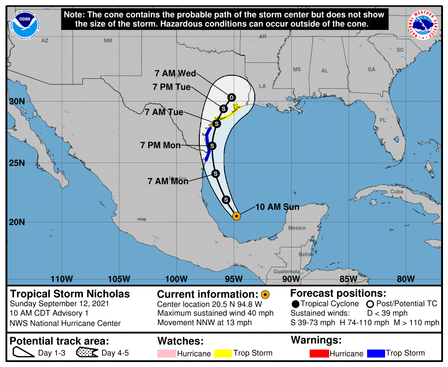
| Loop of the Forecast Tracks from NHC of Nicolas. | Wind History of Nicolas from NHC. |
Youtube Briefings from NWS Houston/Galveston during Event
Useful Links
Latest Post Tropical Cyclone Report. (Will be updated)
National Hurricane Center's Storm Archive
satellite imagery webpage from NOAA.
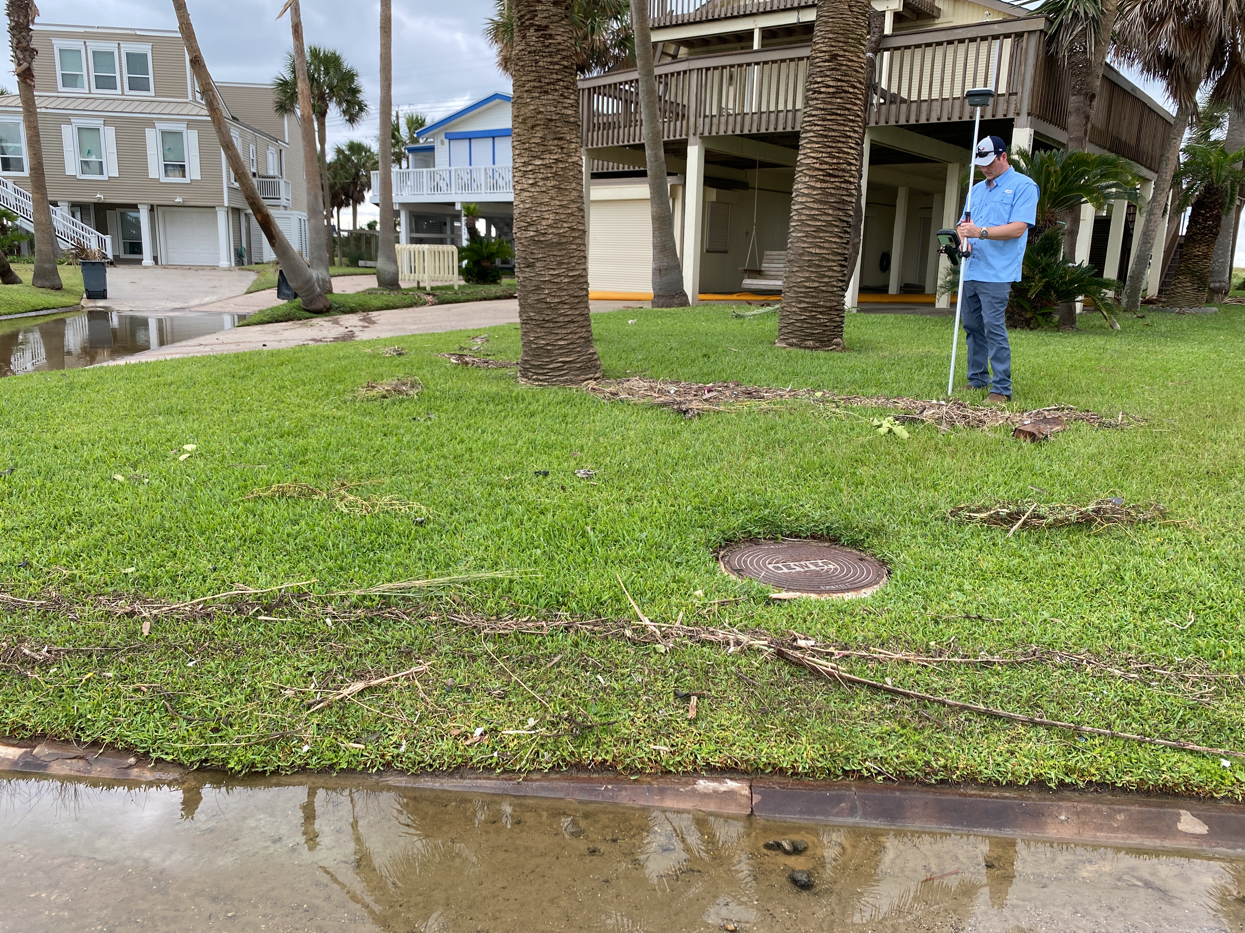
Storm Surge
This space will describe the storm surge impacts of the storm on the Southeast Texas Gulf Coast after damage surveys are completed.
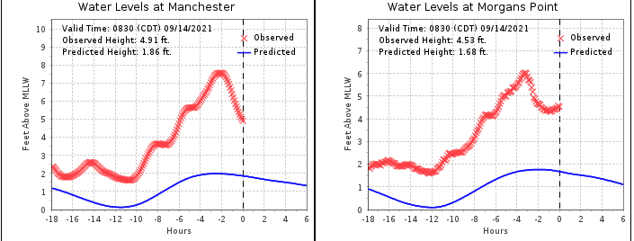 |
| Data showing the peak storm surge at points on the upper portion of Galveston Bay along the Houston Ship Channel |
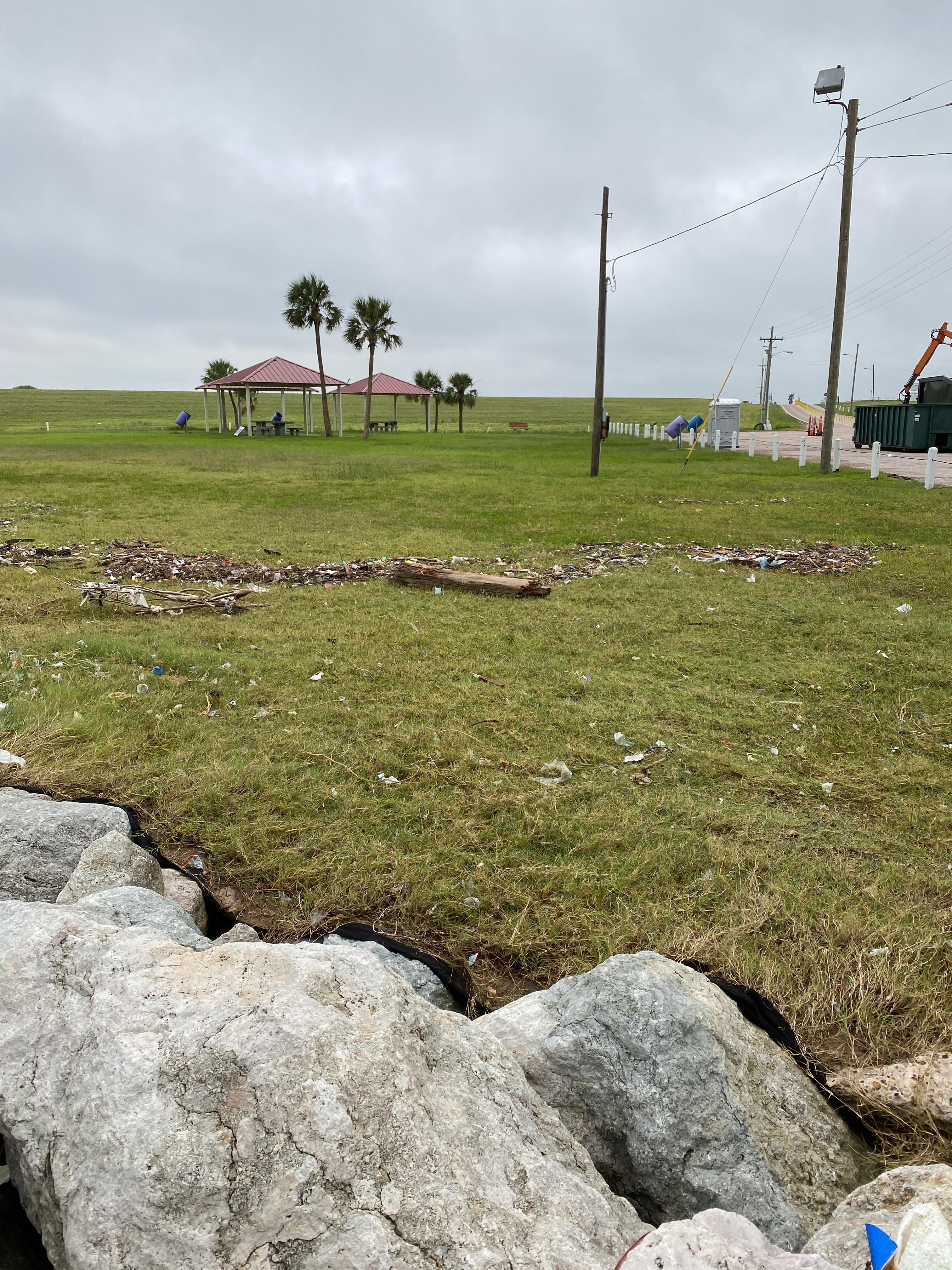
 |
 |
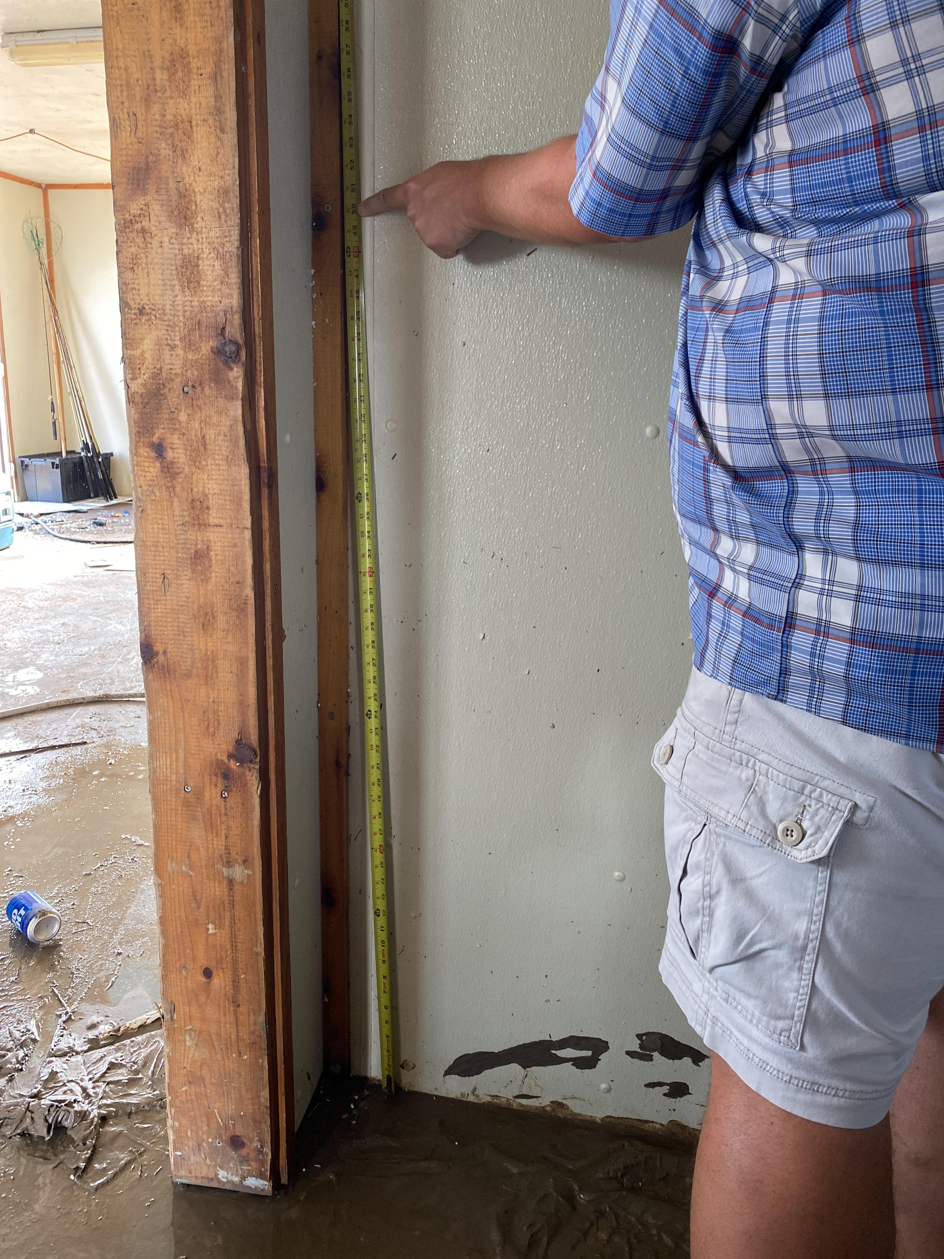 |
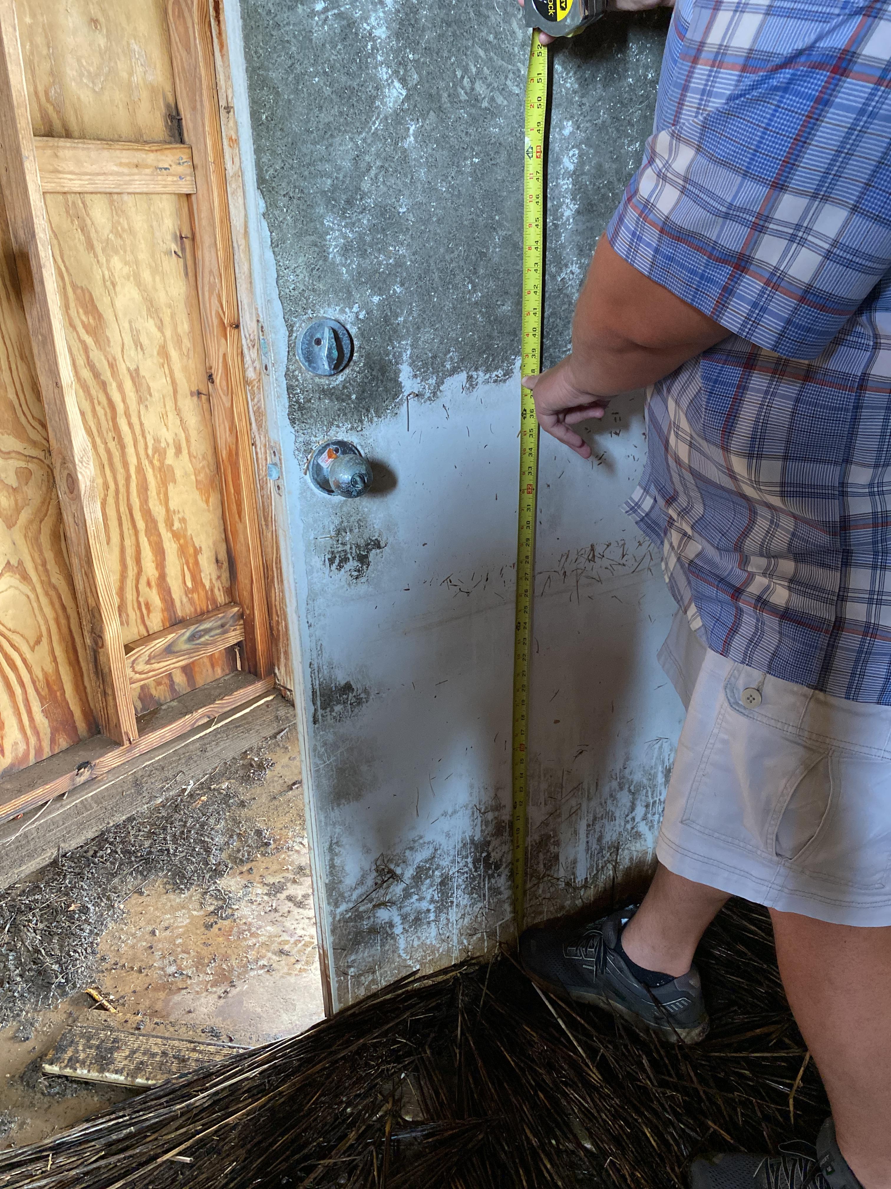
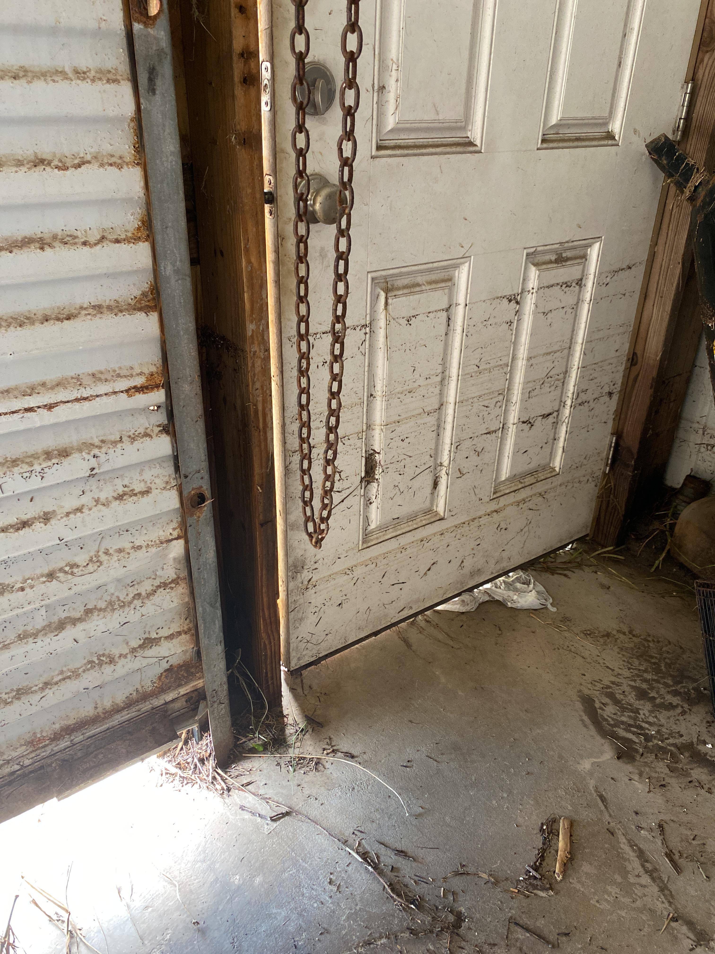
| High water mark - 3.60' AGL near Surfside Beach. | High water mark - 7.70' AGL near Sargent Beach. | High water mark - 4.60' AGL near Rawlings Bait at Matagorda. |
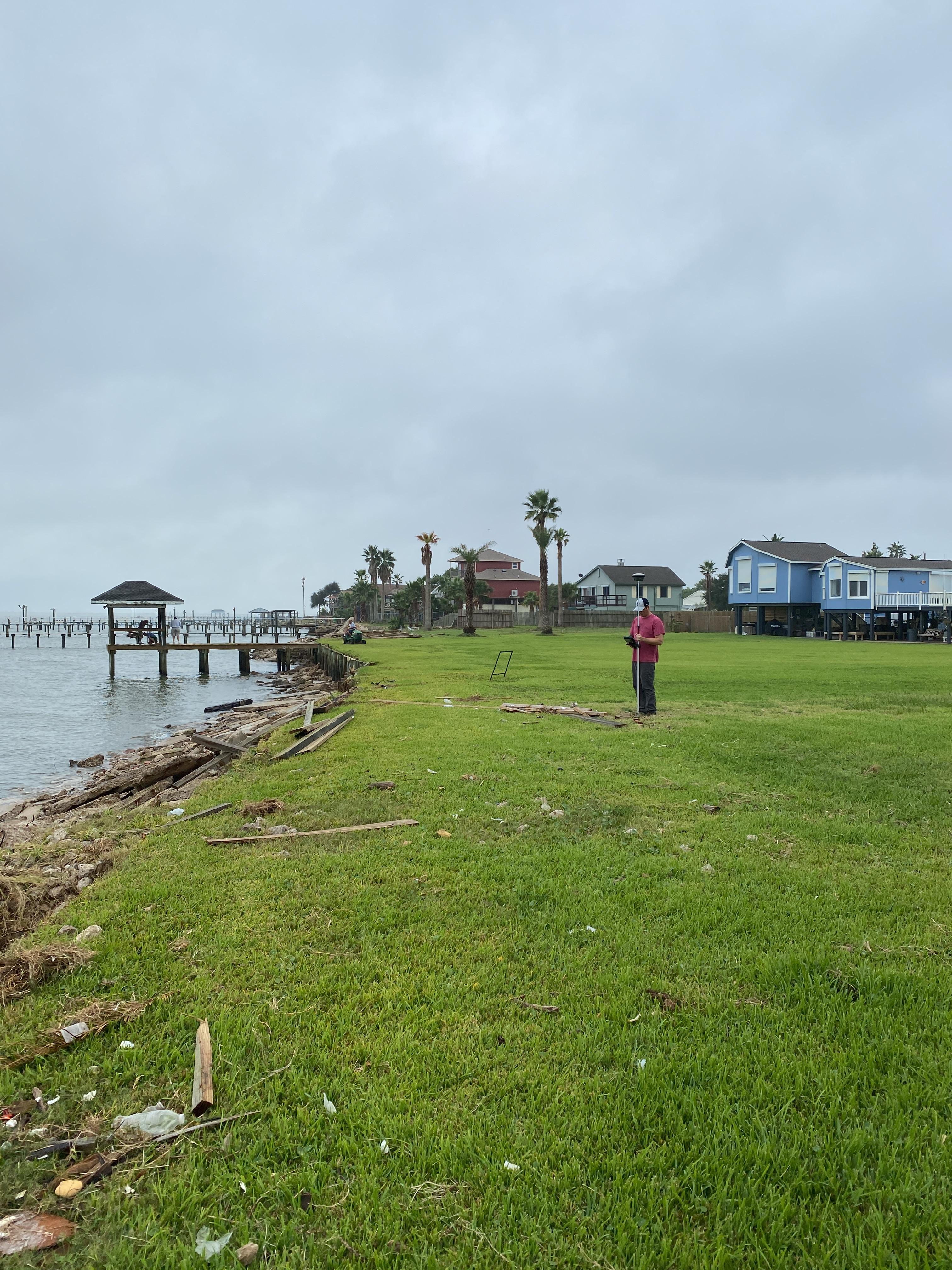
 |
 |
 |
| High water mark - 4.5' AGL at Houston Ship Channel near Juan Seguin Park. | High water mark - 5.4' AGL near Jamaica Beach. | High water mark - 5.20' AGL near Treasure Island. |
 |
 |
 |
| High water mark - 4.10' AGL at Galveston Bay near Seabrool, TX | High water mark - 1.5' AGL at Haney Park near Texas City, TX | High water mark - 5.6' AGL near Dickinson Bay - Bacliff, TX |
SURGE REPORTS
Reports of maximum storm surge will be located here after damage surveys are completed.
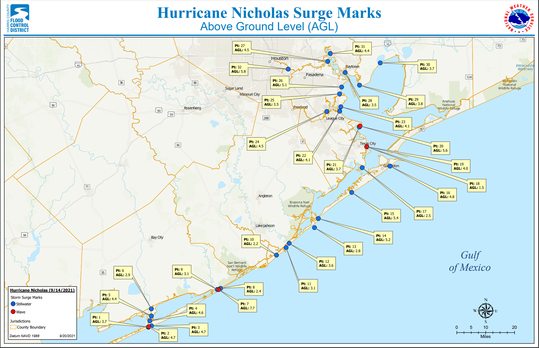
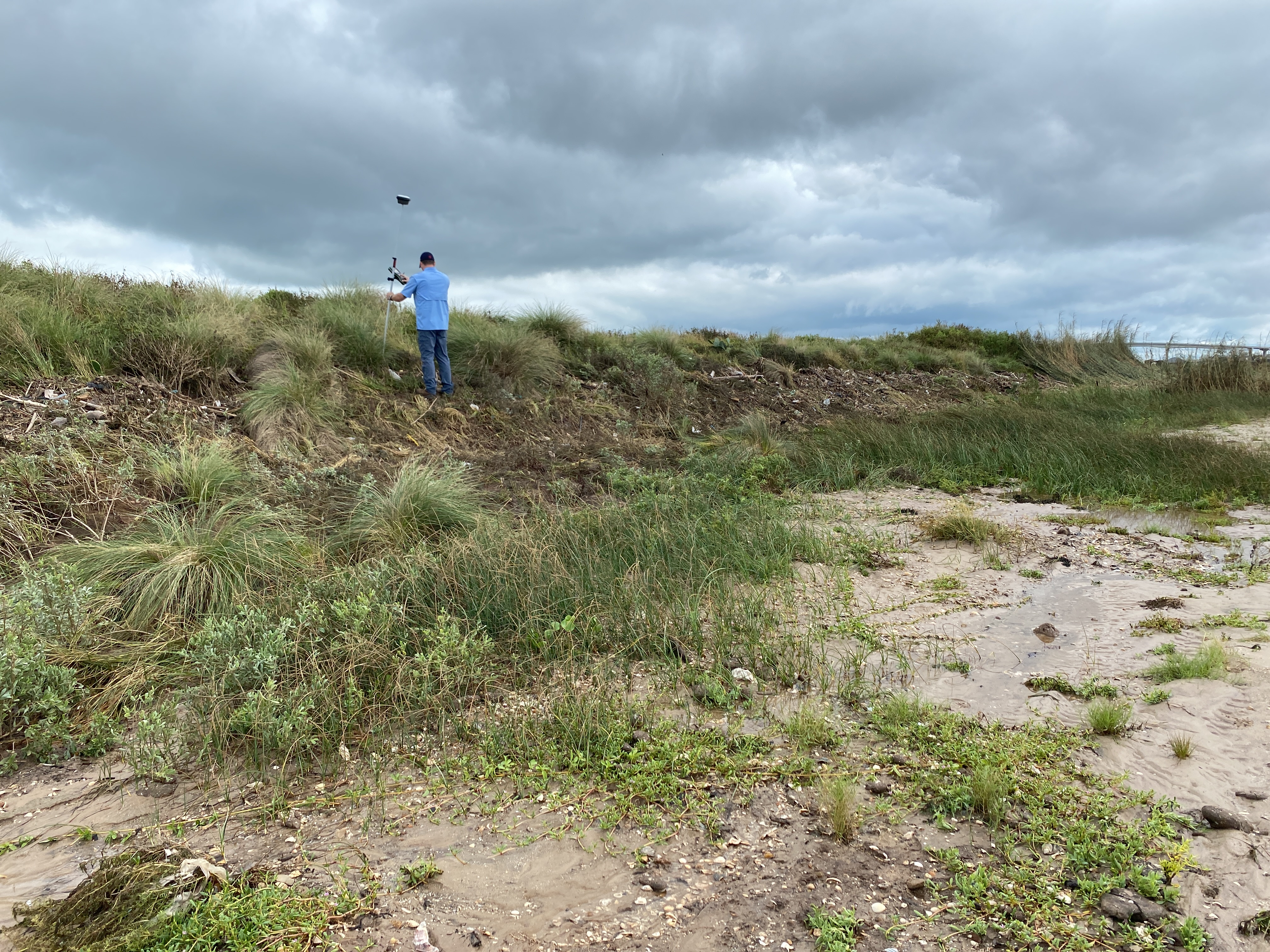
Map of High Water Marks reported around the area. Map created in conjunction with Harris County Flood Control District.
Preliminary SURGE Summary:
ID     CITY/TOWN       COUNTY     STATE  WL  DATUM  DATE/
       OR LOCATION                      (FT)        TIME
-------------------------------------------------------------
MGPT2  MORGANS POINT   HARRIS       TX  4.70 MHHW   14/1018
29.6817  -94.9850

NCHT2  MANCHESTER      HARRIS       TX  5.95 MHHW   14/1124
29.7262  -95.2658

HIST2  HIGH ISLAND     GALVESTON    TX  2.90 MHHW   14/1412
29.5945  -94.3896

RLOT2  ROLLOVER PASS   GALVESTON    TX  3.67 MHHW   14/1300
29.5156  -94.5106

EPTT2  EAGLE POINT     GALVESTON    TX  4.43 MHHW   14/0924
29.4800  -94.9183

GNJT2  GALVESTON BAY E GALVESTON    TX  3.30 MHHW   14/0706
29.3573  -94.7248

GTOT2  GALVESTON PIER  GALVESTON    TX  3.30 MHHW   14/0924
29.3100  -94.7933

GRRT2  GALVESTON RAILR GALVESTON    TX  3.77 MHHW   14/0854
29.3024  -94.8965

LUIT2  SAN LUIS PASS   BRAZORIA     TX  4.26 MHHW   14/0600
29.0810  -95.1313

FCGT2  FREEPORT        BRAZORIA     TX  4.66 MHHW   14/0518
28.9433  -95.3025

SGNT2  SARGENT         MATAGORDA    TX  3.90 MHHW   14/0518
28.7714  -95.6172

EMAT2  MATAGORDA CITY  MATAGORDA    TX  3.26 MHHW   14/0312
28.7101  -95.9140

MBET2  MATAGORDA BAY E CALHOUN      TX  2.76 MHHW   14/0136
28.4269  -96.3301
 |
Media use of NWS Web News Stories is encouraged! Please acknowledge the NWS as the source of any news information accessed from this site. |
|


 Follow us on YouTube