
Heavy rain and flash flooding is likely across portions of the Midwest into the Central and Southern Plains Thursday. A Slight Risk (level 2 of 4) of Excessive Rainfall has been issued. Scattered strong to severe storms will be possible Thursday from parts of the Mississippi River Valley into the Southern Plains. The main threats will be large hail and a few tornadoes. Read More >
Overview - Atmospheric River - October 24-25, 2021
Early Season Storm Brought Historic Heavy Rains and Strong Winds to the Bay Area
|
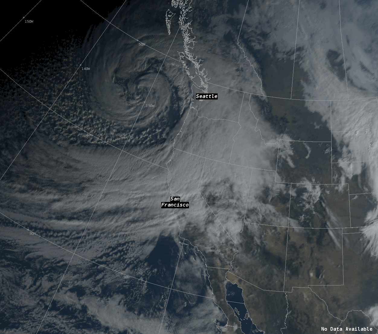
The 2020/2021 Water year ended unceremoniously in the Summer of 2021 with a "status quo" report with little rain during the rainy season leaving dry fuels around the state keeping the region on edge during Fire Season. As the 2021/2022 water season began, the pattern shifted bringing a series of upper level troughs through mid-October toward the Pacific Northwest. As these systems moved toward the California Coastline, it brought light rain in the form of cold fronts along with atypical above average accumulations to the North Bay. By October 18th, long-range models were indicating yet another low that would approach the Pacific Northwest bringing a chance for rain to the Bay Area. However, these model runs depicted a longer stream of moisture that was tapped into the sub-tropics. By the 20th, models were hinting at the chance for a high to moderate "atmospheric river", or AR, event with precipitable water values several standard deviations above the norm. There was reason to doubt initial model runs given that this type of an event is unusually early for the region. But as the event grew closer, it became more and more apparent that the Bay Area was to prepare for a substantial rain event. As the parent low pressure system moved toward Seattle and its central pressure rapidly intensified, undergoing bomb-cyclogenesis. Light showers already were showing up in the North Bay late on the evening of October 23rd. As the sun rose on the 24th, the water content increased exponentially bringing moderate to heavy rainfall around the Bay Area. Winds out of the southwest increased causing a Wind Advisory to be issued for the entire Bay Area. At higher elevations, winds were observed between 50 to 60 mph with peak gusts between 70 to 80 mph, with gusts at KSFO measured up to 50 mph. Flood Warnings and Flood Advisories were issued throughout the day from the North Bay, down the San Mateo coastline for flood risks in urban locations and small streams. A Flash Flood Warning was issued for the Glass Fire burn scar due to a period of intense rainfall rates. Storm reports that were submitted included flooding, downed trees, power outages, and some minor mud slides. By day's end, October 24th, 2021 will go down as the wettest day for many cities around the Bay Area, setting records along the way. For more information on record rainfall, see the 'Heavy Rain' tab below. The deep low pressure system driving the atmospheric river also generated historically large and powerful waves along the west coast from Washington to California. Buoys situated along the coast reported significant wave set heights of around 30 feet along and in the wake of the storm, with peak individual wave heights of 50 to 60 feet, making this wave event the 2nd largest in the 23 year history of the Point Reyes (46029) CDIP buoy (Dec 2015 was larger). An early season high surf warning was in effect as these energetic, large waves crashed into our coastline and overran many of our west to northwest facing beaches on Monday the 25th. In addition, excessive runoff from the previous 24 hours of stormy weather led to an overly brown hue to the waves. Forecasters past and present made similar observations of this wave event: while the breaking waves were indeed very large, they were not the absolute largest waves they had observed around the region. Instead, the amount of big wave energy running up the coast/beaches struck forecasters as most impressive. For example, at Carmel Beach, water overran the majority of the beach Monday morning and rhythmically splashed against the sea wall well at the opposite end of the beach. Similar scenes played out elsewhere as many beaches were still transitioning out of their less resilient summer configurations (ie, not as steep, lacking significant sand bars) when this very large, very early season event arrived. The atmospheric river gradually moved southward toward Los Angeles on the 25th.
CW3E also included a thorough write up on the Atmospheric River here: https://https://cw3e.ucsd.edu/cw3e-event-summary-19-26-october-2021/
Composed by: DKing and MMehle |
|
Atmospheric River October 24-25, 2021
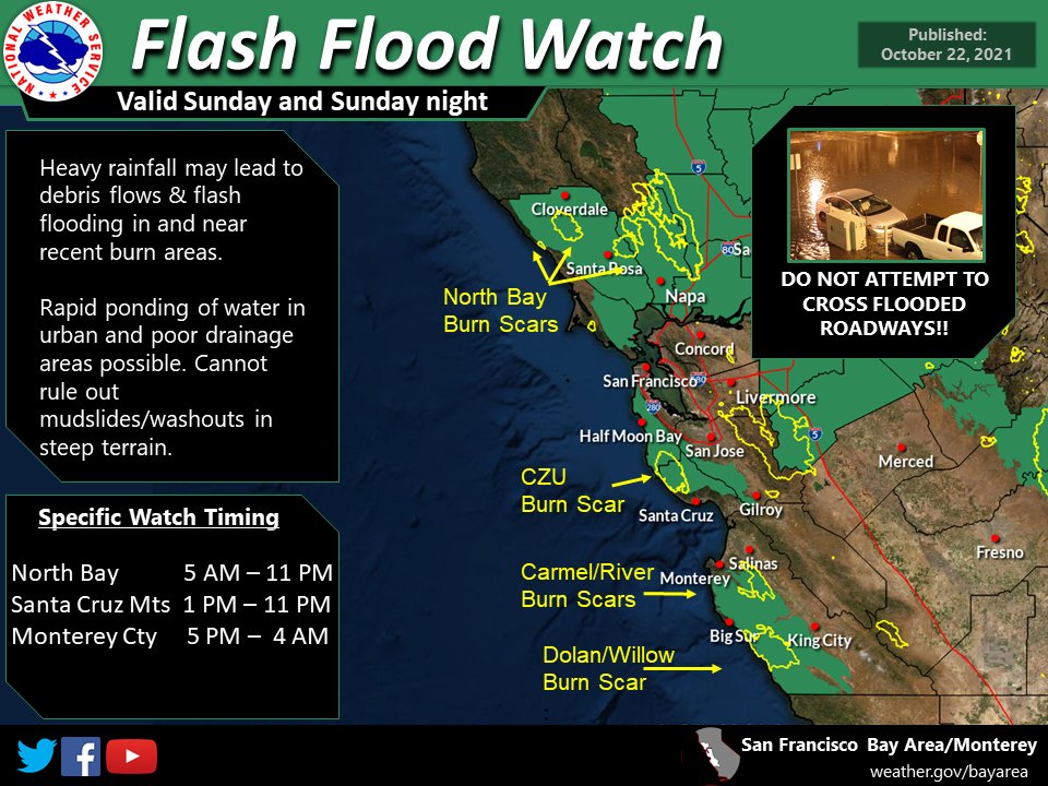
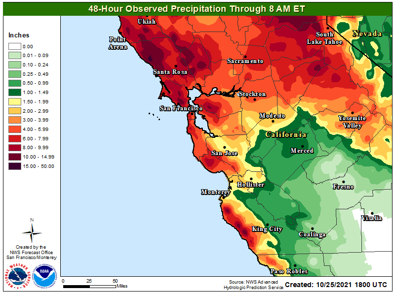
Rain started late on Saturday the 23rd, but the main event was forecast for Sunday the 24th, before slowly diminishing as the system moved toward Southern California. Higher elevations of the North Bay received over a foot of rainfall, with most lower level areas receiving 5" to 10" increases, helping to quell the risk of fire season. Flood Warnings and Flood Advisories for urban and small stream flooding as well as a Flash Flood Warning for the Glass Fire burn scar were.
 |
 |
 |
 |
|
Lead Up to the AR Flash Flood Watches were issued. |
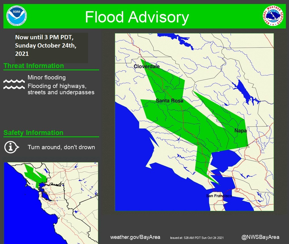
An example of the many Flood Advisories that were issued for urban and small stream flooding due to persistent rain. |
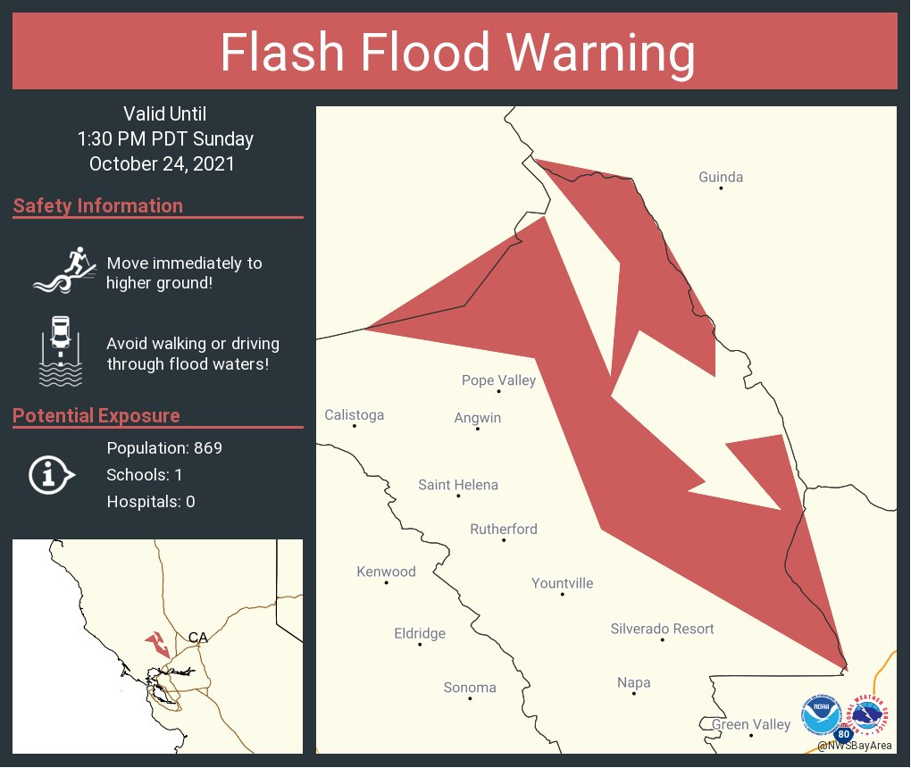
Flash Flood Warning issued for Glass Fire Burn Area |
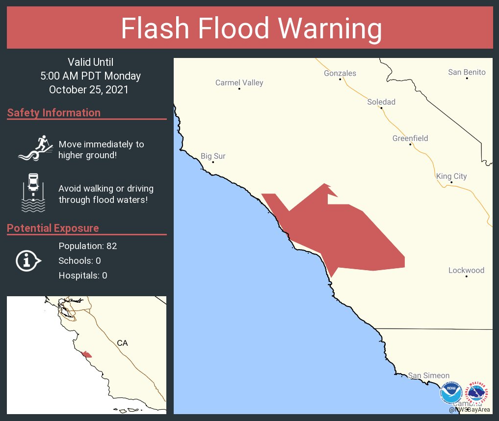
Flash Flood Warning issued for Dolan Fire Burn Area |
 |
 |
 |
 |
|
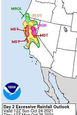
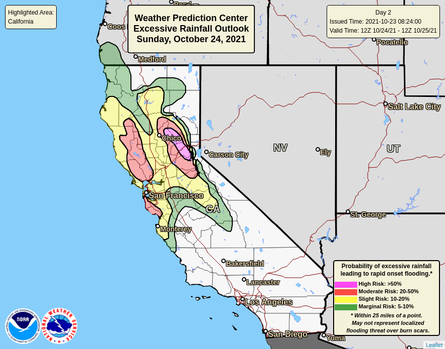
WPC issued a moderate risk potential for flash flooding along the Central Coast Oct 22, 2021 |
WPC issued a high risk potential for flash flooding along the Central Coast Oct 23, 2021 |
WPC issued a moderate risk potential for flash flooding along the Central Coast Oct 24, 2021 |
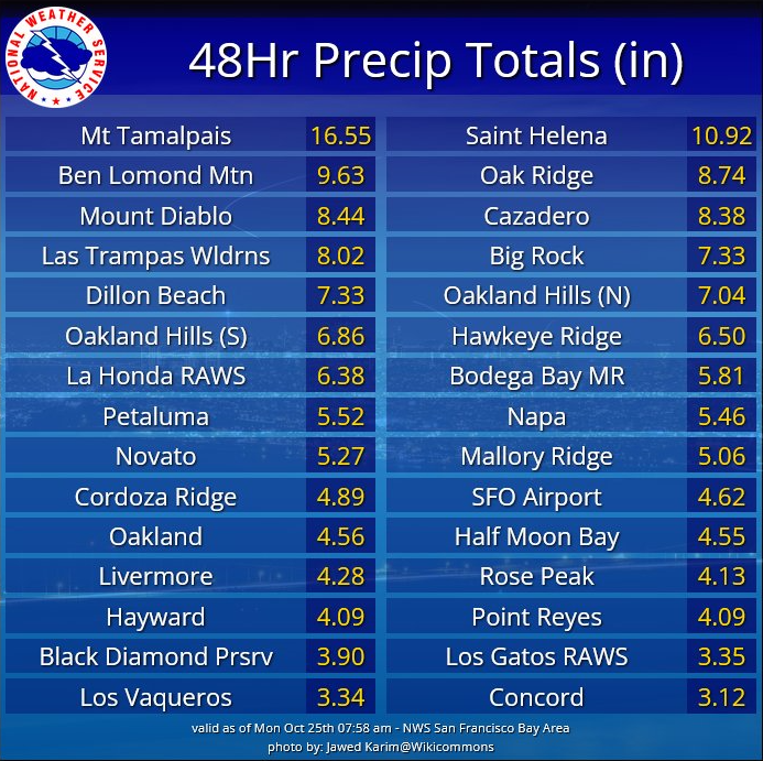
48 hour rainfall totals ending Oct 25, 2021 |
 |
 |
 |
|
|
48 hour rainfall totals ending Oct 25, 2021 |
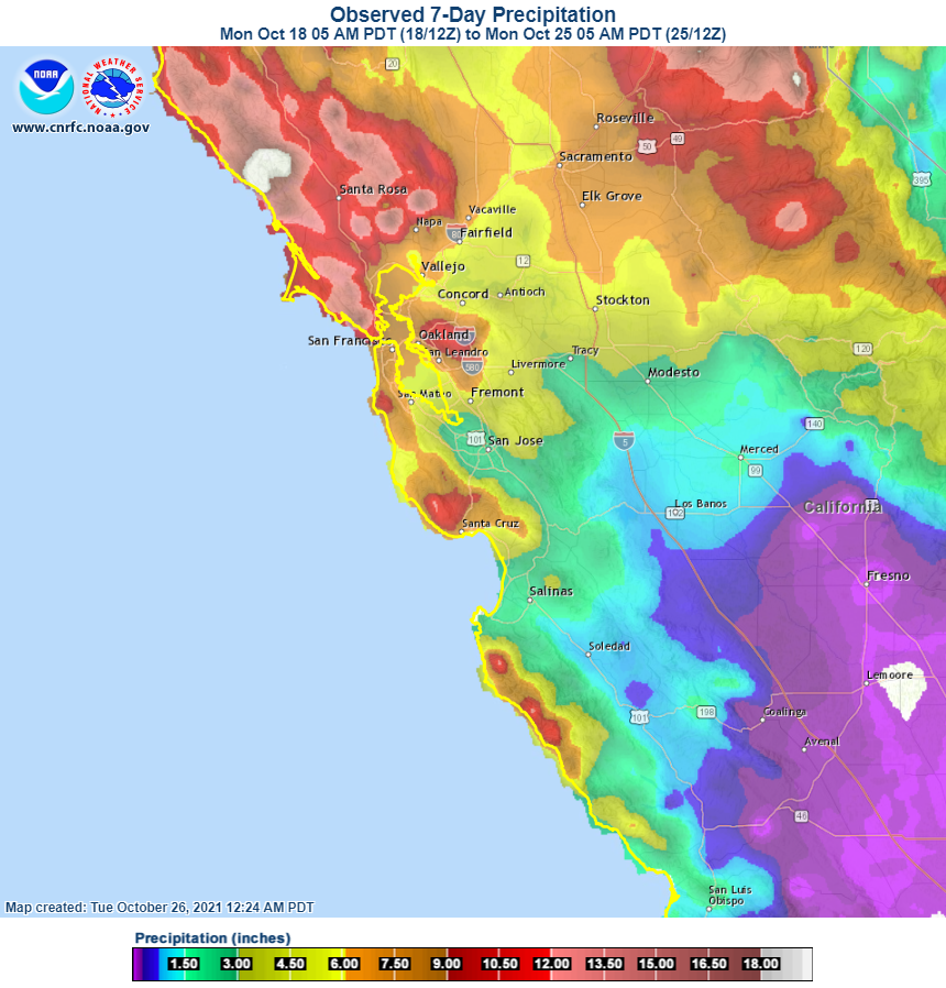
7-Day rainfall totals |
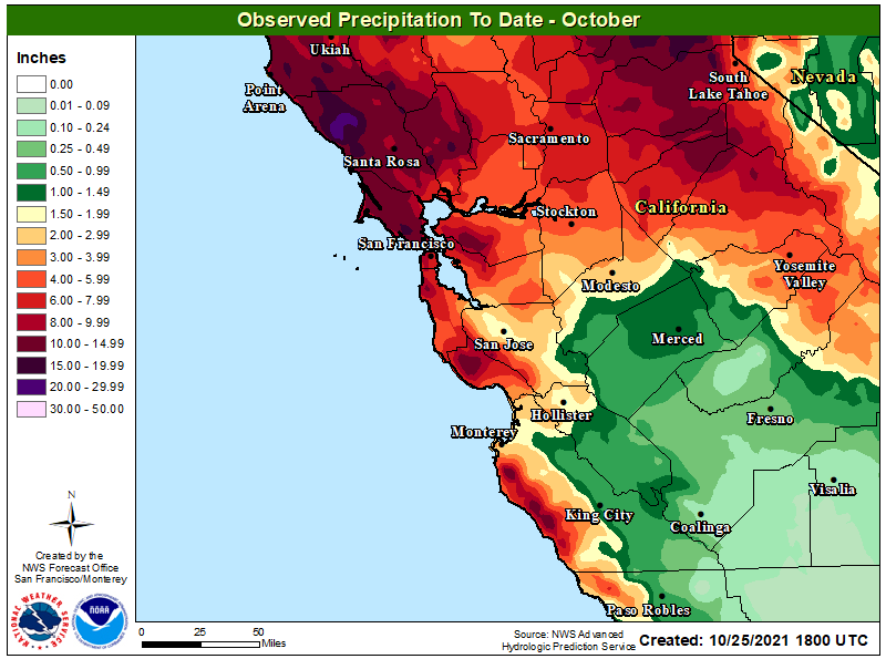
Estimated rainfall totals for the month of Oct |
|
RECORD EVENT REPORT NATIONAL WEATHER SERVICE SAN FRANCISCO BAY AREA 804 PM PDT MON OCT 25 2021 ...RECORD DAILY PRECIPITATION RECORDS SET ON OCTOBER 24 2021... LOCATION PRECIP(IN) PREVIOUS RECORD ------------------------------------------------------------- SANTA ROSA 7.83* 4.67 IN 1962 KENTFIELD 11.09 6.14 IN 2009 NAPA 5.35 4.66 IN 1962 SAN FRANCISCO DOWNTOWN 4.02 2.48 IN 2009 SFO 4.02 2.64 IN 2009 OAKLAND DOWNTOWN 4.28 3.87 IN 2009 *ALSO A SINGLE DAY DAILY RECORD. PREVIOUS DAILY RECORD WAS 5.66(IN) ON 02/26/2019 ALL DATA SHOULD BE CONSIDERED PRELIMINARY. OFFICIAL AND CERTIFIED CLIMATE DATA ARE AVAILABLE FROM THE NATIONAL CENTERS FOR ENVIRONMENTAL INFORMATION: WWW.NCEI.NOAA.GOV. $$ |
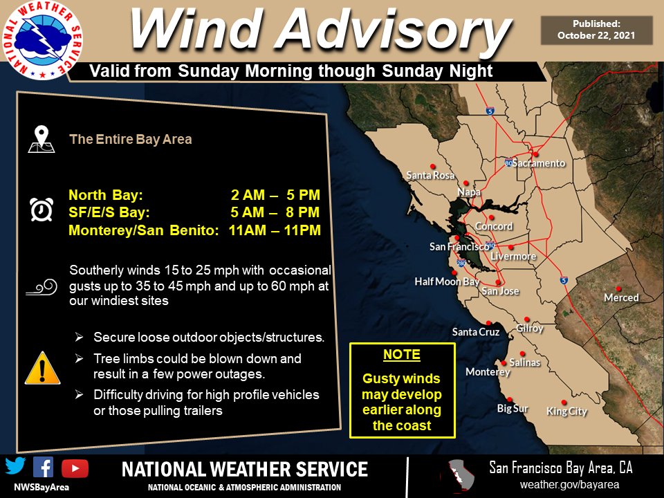
Gusty Southerly Winds
Strong south-southwesterly winds were along the leading edge of the atmospheric river. Winds aloft were at their strongest, causing wind gusts at higher peaks and ridges from 70 to 80 mph max. As wind gusts increased at the surface, it prompted the issuance of an Airport Weather Warning at KSFO due to wind gusts between 45 to 50 mph for several hours. Widespread reports of downed trees and powerlines came as a result of the high winds.
 |
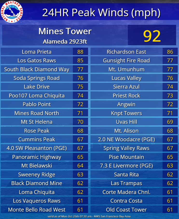 |
| Wind Advisory issued for the entire Bay Area and the Central Coast. | 24 hour peak wind gusts. |
Video of Strong Winds on Mt. Umunhum
Public Information Statement National Weather Service San Francisco CA 638 AM PDT Mon Oct 25 2021 ...24 HOUR PEAK WIND REPORTS... Location Speed Time/Date Lat/Lon/Elev (ft.) ...California... ...Alameda County... Mines Tower 92 MPH 0110 PM 10/24 37.61N/121.62W/2923 Mines Road North 71 MPH 1120 AM 10/24 37.61N/121.67W/1541 Mt. Alison 68 MPH 0340 PM 10/24 37.50N/121.87W/2646 Rose Peak 68 MPH 1128 AM 10/24 37.50N/121.74W/3060 4.0 SW Pleasanton (PGE) 67 MPH 0220 PM 10/24 37.62N/121.92W/2134 7.3 E Livermore (PGE) 63 MPH 0220 PM 10/24 37.69N/121.63W/1604 5.5 E Fremont (PGE) 62 MPH 0650 AM 10/24 37.55N/121.90W/1138 Calaveras Rd Raws 61 MPH 0218 PM 10/24 37.55N/121.84W/1229 Mendenhall Springs 60 MPH 1120 AM 10/24 37.60N/121.64W/1619 Oakland N Raws 59 MPH 0233 PM 10/24 37.87N/122.22W/1402 Weller Road 55 MPH 0400 PM 10/24 37.49N/121.86W/2461 Arroyo Hills 55 MPH 1100 AM 10/24 37.60N/121.75W/1463 2.9 N Piedmont (PGE) 54 MPH 0150 PM 10/24 37.87N/122.22W/1475 Santos 54 MPH 1210 PM 10/24 37.66N/121.93W/1473 Altamont Raws 51 MPH 1012 AM 10/24 37.69N/121.61W/1436 6.6 SE Livermore (PGE) 51 MPH 1130 AM 10/24 37.61N/121.70W/1123 8.0 SE Livermore (PGE) 50 MPH 0210 PM 10/24 37.59N/121.69W/1129 2.8 SE Fairview (PGE) 50 MPH 0310 PM 10/24 37.66N/122.00W/1495 5.2 SW Livermore (PGE) 48 MPH 1040 AM 10/24 37.63N/121.81W/847 Fremont Hills 47 MPH 0240 PM 10/24 37.62N/121.97W/1527 Livermore Airport 46 MPH 1118 AM 10/24 37.70N/121.82W/399 Blackstone Court 46 MPH 1220 PM 10/24 37.68N/122.04W/701 Oakland Airport 45 MPH 0243 PM 10/24 37.72N/122.23W/8 Oakland Middle Harbor, CA 45 MPH 0130 PM 10/24 37.80N/122.33W Mill Creek 45 MPH 0540 PM 10/24 37.52N/121.87W/1554 2.7 SE Kensington (UUNET) 44 MPH 0300 PM 10/24 37.88N/122.25W/888 Dagnino Road 44 MPH 1230 PM 10/24 37.74N/121.75W/550 Alameda Marina 43 MPH 0215 PM 10/24 37.77N/122.29W/57 I-580 - I-205 42 MPH 0220 PM 10/24 37.74N/121.57W/300 Dublin Canyon Road 42 MPH 0140 PM 10/24 37.69N/121.98W/1035 Berkeley 41 MPH 1236 PM 10/24 37.86N/122.28W/104 Las Positas College 41 MPH 1134 AM 10/24 37.71N/121.81W/518 Alameda, CA 40 MPH 0100 PM 10/24 37.77N/122.30W Dublin - Murray Elementary 40 MPH 0150 PM 10/24 37.72N/121.93W/360 Livermore 39 MPH 0217 PM 10/24 37.66N/121.70W/728 Sunol 39 MPH 1245 PM 10/24 37.50N/121.90W/1040 East Bay Mud 39 MPH 1240 PM 10/24 37.78N/122.09W/969 Royce Beach/Toll Plaza 39 MPH 1202 PM 10/24 37.83N/122.32W/15 Alameda 38 MPH 0139 PM 10/24 37.78N/122.30W/13 Reuss Road 37 MPH 1250 PM 10/24 37.66N/121.66W/937 Calhoun Street 36 MPH 1250 PM 10/24 37.65N/122.05W/446 Rifle Range Road 36 MPH 1240 PM 10/24 37.76N/122.08W/894 Oakland 36 MPH 1050 AM 10/24 37.80N/122.27W/36 Hayward 36 MPH 1237 PM 10/24 37.67N/122.12W/42 Newark Ems 35 MPH 1120 AM 10/24 37.51N/121.99W/15 Hayward 35 MPH 1250 PM 10/24 37.66N/122.05W/648 Kelly Canyon 35 MPH 0320 PM 10/24 37.71N/121.99W/699 Oakland Idsm 35 MPH 0120 PM 10/24 37.76N/122.22W/9 Peninsula Road 34 MPH 1150 AM 10/24 37.79N/122.13W/755 Oakland 33 MPH 1040 AM 10/24 37.80N/122.16W/1185 2.1 E Piedmont (PGE) 33 MPH 0930 AM 10/24 37.82N/122.19W/1184 4.1 S Moraga Town (PGE) 33 MPH 0130 PM 10/24 37.79N/122.15W/1234 Fremont 32 MPH 0551 AM 10/25 37.54N/121.97W/58 Berkeley 30 MPH 0125 PM 10/24 37.86N/122.24W/360 Oakland S Raws 30 MPH 1233 PM 10/24 37.79N/122.14W/1095 ...Contra Costa County... South Black Diamond Way 77 MPH 1240 PM 10/24 37.94N/121.89W/1881 Cummins Peak 67 MPH 1210 PM 10/24 38.03N/122.20W/817 Las Trampas 62 MPH 0828 AM 10/24 37.83N/122.07W/1759 Black Diamond Mine 62 MPH 1240 PM 10/24 37.96N/121.89W/975 Contra Costa 61 MPH 0230 PM 10/24 37.92N/121.98W/892 Los Vaqueros Raws 61 MPH 0145 PM 10/24 37.79N/121.73W/1100 Diablo-Blackhawk 60 MPH 0230 PM 10/24 37.84N/121.90W/1916 Byron Hills 57 MPH 0140 PM 10/24 37.84N/121.72W/314 Fay Hill 56 MPH 1250 PM 10/24 37.86N/122.12W/861 Alcosta Boulevard 56 MPH 0240 PM 10/24 37.75N/121.93W/768 Moraga Bluffs 55 MPH 1120 AM 10/24 37.84N/122.09W/858 8.8 N Livermore (PGE) 55 MPH 0110 PM 10/24 37.82N/121.78W/2500 Black Diamond Raws 51 MPH 0128 PM 10/24 37.95N/121.88W/1600 Black Diamond Mines 50 MPH 0240 PM 10/24 37.98N/121.86W/710 Garcia Ranch Road 50 MPH 0140 PM 10/24 37.94N/122.17W/1103 Briones Raws 50 MPH 0128 PM 10/24 37.93N/122.12W/1450 5.8 SE Blackhawk (PGE) 49 MPH 0100 PM 10/24 37.78N/121.82W/827 2.8 E El Sobrante (PGE) 48 MPH 0220 PM 10/24 37.97N/122.24W/242 3.3 SW Martinez (PGE) 48 MPH 1240 PM 10/24 37.96N/122.14W/793 Shadowhawk 48 MPH 1230 PM 10/24 37.85N/122.17W/771 Mallory Ridge Raws 47 MPH 0302 PM 10/24 37.82N/121.78W/1948 5.6 E Blackhawk (PGE) 47 MPH 0110 PM 10/24 37.81N/121.81W/2490 Clayton 46 MPH 1226 PM 10/24 37.94N/121.93W/1512 2.6 NW Orinda (PGE) 46 MPH 0200 PM 10/24 37.91N/122.20W/689 Shadowhawk 46 MPH 1240 PM 10/24 37.86N/122.06W/800 Richmond 45 MPH 0125 PM 10/24 37.91N/122.35W/164 3.0 S Antioch (PGE) 45 MPH 1240 PM 10/24 37.95N/121.81W/336 Briones-Diablo 45 MPH 0220 PM 10/24 37.89N/122.01W/743 Avila Road 44 MPH 1250 PM 10/24 38.02N/121.99W/444 Pinole 43 MPH 1217 PM 10/24 37.98N/122.26W/284 7 NNW Livermore 41 MPH 0125 PM 10/24 37.79N/121.79W/1552 Concord 40 MPH 1238 PM 10/24 37.96N/122.00W/242 Byron 40 MPH 0315 PM 10/24 37.83N/121.62W/30 Byron 40 MPH 0255 PM 10/24 37.83N/121.62W/79 North Dublin 39 MPH 0220 PM 10/24 37.75N/121.86W/573 Hercules 39 MPH 0131 PM 10/24 38.03N/122.28W/13 Hercules 39 MPH 0115 PM 10/24 38.01N/122.29W/12 Lakewood Meadow 38 MPH 0150 PM 10/24 37.93N/122.00W/395 Pittsburg Marina 38 MPH 1115 AM 10/24 38.03N/121.88W/32 El Sobrante 38 MPH 0155 PM 10/24 37.97N/122.30W/234 Concord Airport 38 MPH 1111 AM 10/24 38.00N/122.05W/22 Port Chicago, CA 37 MPH 1224 PM 10/24 38.06N/122.04W 6.0 N Livermore (PGE) 37 MPH 0240 PM 10/24 37.77N/121.73W/811 1 SSW West Pittsburg 35 MPH 1100 AM 10/24 38.02N/121.98W/22 Walnut Creek 35 MPH 1100 AM 10/24 37.89N/122.04W/295 El Cerrito 35 MPH 1055 AM 10/24 37.91N/122.29W/475 Sycamore Springs Road 34 MPH 0310 PM 10/24 37.89N/121.81W/426 Alamo 34 MPH 1157 AM 10/24 37.86N/122.02W/360 Caballo Ranchero Drive 34 MPH 0310 PM 10/24 37.84N/121.95W/893 Bailey Road 33 MPH 0700 AM 10/24 38.01N/121.94W/290 Brentwood 33 MPH 1130 AM 10/24 37.97N/121.72W/88 Martinez 33 MPH 1142 AM 10/24 37.98N/122.13W/462 Wilder Hills 33 MPH 1130 AM 10/24 37.85N/122.18W/1345 Moraga 32 MPH 1255 PM 10/24 37.82N/122.13W/418 Walnut Creek 32 MPH 0125 PM 10/24 37.92N/122.01W/177 4.9 SE Clayton (PGE) 32 MPH 0150 PM 10/24 37.90N/121.86W/624 Cliffecastle Court 32 MPH 0720 AM 10/24 37.74N/121.99W/1464 Brentwood 31 MPH 0237 PM 10/24 37.90N/121.72W/180 0.9 NW Kensington (PGE) 31 MPH 0110 PM 10/24 37.92N/122.29W/773 5.8 N Orinda (PGE) 30 MPH 0220 PM 10/24 37.96N/122.20W/1007 3.1 SW Martinez (PGE) 30 MPH 0130 PM 10/24 37.97N/122.16W/659 Reliez Valley Road 30 MPH 0110 PM 10/24 37.95N/122.11W/329 ...Marin County... Richardson East 86 MPH 1220 PM 10/24 37.85N/122.50W/1109 Gunsight Fire Road 77 MPH 1010 AM 10/24 38.02N/122.63W/1148 Lucas Valley 76 MPH 1040 AM 10/24 38.05N/122.60W/1636 Pablo Point 72 MPH 1000 AM 10/24 38.09N/122.69W/937 2.0 NE Woodacre (PGE) 67 MPH 1030 AM 10/24 38.03N/122.62W/1290 Panoramic Highway 65 MPH 1230 PM 10/24 37.89N/122.56W/752 Point Blunt-Angel Island (MT 60 MPH 0200 PM 10/24 37.85N/122.42W/69 Duck Cove Road 57 MPH 1000 AM 10/24 38.14N/122.92W/354 Novato Fire - Robinhood 57 MPH 1231 PM 10/24 38.11N/122.55W/481 Pt Blunt Angel Island 56 MPH 0146 PM 10/24 37.85N/122.42W/10 1.3 W Woodacre (PGE) 55 MPH 1250 PM 10/24 38.00N/122.66W/1321 Cerini Road 55 MPH 1130 AM 10/24 38.23N/122.86W/519 Snake Road 55 MPH 0820 AM 10/24 38.22N/122.92W/512 Sand Haul Road 54 MPH 1130 AM 10/24 38.25N/122.95W/306 Larkspur Landing 54 MPH 1208 PM 10/24 37.94N/122.51W/30 Mount Tamalpais RAWS 51 MPH 0836 AM 10/24 37.93N/122.59W/2338 Big Rock 51 MPH 1233 PM 10/24 38.04N/122.57W/1500 3.4 NE Bolinas (PGE) 51 MPH 1230 PM 10/24 37.95N/122.68W/1623 Woodacre Raws 51 MPH 1051 AM 10/24 37.99N/122.64W/1399 Tiburon 49 MPH 0730 AM 10/24 37.89N/122.46W/534 2.1 W Mill Valley (PGE) 48 MPH 0140 PM 10/24 37.91N/122.58W/1033 2.7 N Woodacre (PGE) 48 MPH 0930 AM 10/24 38.04N/122.65W/794 6.0 W Inverness (DRI) 48 MPH 1140 AM 10/24 38.09N/122.95W/86 Arroya Sausal Road 47 MPH 0940 AM 10/24 38.14N/122.79W/538 2.8 W Novato (PGE) 46 MPH 1030 AM 10/24 38.09N/122.61W/375 Tomales Shadow 45 MPH 0950 AM 10/24 38.18N/122.83W/207 Novato Airport 44 MPH 1155 AM 10/24 38.15N/122.55W/1 6.5 SW Petaluma (PGE) 43 MPH 0830 AM 10/24 38.16N/122.69W/649 Tomales Bay 43 MPH 1202 PM 10/24 38.18N/122.91W/16 4.3 N Lagunitas-Forest Knoll 42 MPH 1230 PM 10/24 38.08N/122.67W/275 Nicasio Valley Road 41 MPH 0950 AM 10/24 38.10N/122.73W/241 Barnaby Raws 41 MPH 1011 AM 10/24 38.03N/122.70W/810 8.0 SW Petaluma (PGE) 41 MPH 0830 AM 10/24 38.14N/122.70W/418 0.8 NE San Rafael (PGE) 41 MPH 1020 AM 10/24 37.99N/122.50W/1002 3.6 NW Lagunitas-Forest Knol 40 MPH 0830 AM 10/24 38.04N/122.74W/401 Mill Valley 39 MPH 0215 PM 10/24 37.92N/122.59W/1824 Sausalito 39 MPH 1135 AM 10/24 37.86N/122.50W/155 Novato 37 MPH 0929 AM 10/24 38.10N/122.58W/32 Lagunitas 37 MPH 1208 PM 10/24 38.02N/122.71W/925 6.5 SE Occidental (CARB) 36 MPH 0900 AM 10/24 38.31N/122.90W/15 Novato 36 MPH 0843 AM 10/24 38.11N/122.61W/216 Ignacio Ems 35 MPH 1000 AM 10/24 38.08N/122.54W/3 1.7 SW Fairfax (PGE) 35 MPH 0920 AM 10/24 37.97N/122.61W/687 Point Reyes 35 MPH 0940 AM 10/24 38.08N/122.87W/1328 5.3 W Inverness (MTRWFO) 35 MPH 1205 PM 10/24 38.10N/122.94W/83 San Anselmo 32 MPH 1125 AM 10/24 37.98N/122.58W/98 3.4 W Lagunitas-Forest Knoll 32 MPH 0950 AM 10/24 38.00N/122.75W/485 6.6 SW Petaluma (PGE) 31 MPH 1250 PM 10/24 38.18N/122.72W/463 Burdell Mountain 30 MPH 1030 AM 10/24 38.15N/122.59W/1480 ...Monterey County... Old Coast Tower 61 MPH 1040 PM 10/24 36.32N/121.87W/1207 16.9 NW Lake Nacimiento (PGE 54 MPH 1240 AM 10/25 35.95N/121.00W/2790 12.4 SW Carmel Valley Vill ( 54 MPH 0820 PM 10/24 36.38N/121.90W/403 Long Ridge 53 MPH 0640 PM 10/24 36.43N/121.74W/2003 Pinnacles National Park 52 MPH 1020 PM 10/24 36.45N/121.29W/597 Pebble Beach 51 MPH 0915 PM 10/24 36.58N/121.97W/91 Shulte Road 51 MPH 1240 PM 10/24 36.51N/121.83W/1137 Pebble Beach 49 MPH 1000 PM 10/24 36.57N/121.97W/91 12.7 SW Carmel Valley Vill ( 49 MPH 1040 PM 10/24 36.35N/121.88W/995 6.0 N Gonzales (PGE) 48 MPH 1220 PM 10/24 36.59N/121.43W/944 Hunter Liggett 48 MPH 1250 AM 10/25 35.95N/121.23W/1828 Mt. Devin Road 48 MPH 0320 PM 10/24 36.50N/121.91W/1644 24.9 SW Greenfield (DRI) 47 MPH 1110 PM 10/24 36.07N/121.56W/2490 6.2 NE Greenfield (PGE) 47 MPH 1240 AM 10/25 36.37N/121.15W/4404 7.0 E Carmel Valley Vill (PG 47 MPH 1030 PM 10/24 36.53N/121.61W/3452 15.0 S Coalinga (PGE) 47 MPH 0130 AM 10/25 35.93N/120.37W/3297 Jolon Road 47 MPH 0100 AM 10/25 36.11N/121.17W/1305 Corral De Cielo Road 47 MPH 0150 PM 10/24 36.53N/121.62W/3385 Laureles Grade 46 MPH 0900 PM 10/24 36.53N/121.75W/1372 17.0 S Carmel Valley Vill (P 46 MPH 1150 PM 10/24 36.25N/121.79W/904 Calfire Portable 43 46 MPH 1015 PM 10/24 36.29N/121.85W/490 Monterey 45 MPH 0830 PM 10/24 36.60N/121.89W Sky Ranch Road 44 MPH 0610 PM 10/24 36.43N/121.68W/1814 Monterey Airport 44 MPH 0108 PM 10/24 36.58N/121.85W/196 Arroyo Seco Road 43 MPH 0850 PM 10/24 36.25N/121.44W/1620 Parker Flats Cutoff 41 MPH 0130 PM 10/24 36.63N/121.79W/436 Stone Canyon 41 MPH 1240 AM 10/25 36.02N/120.52W/3375 Lonoak 41 MPH 0240 PM 10/24 36.29N/120.94W/925 Salinas Airport 41 MPH 0905 PM 10/24 36.67N/121.60W/91 Pacific Grove 40 MPH 0258 PM 10/24 36.62N/121.92W/183 10.5 NE Hearst Castle (PGE) 40 MPH 0250 AM 10/25 35.81N/121.05W/1515 Palo Escrito 40 MPH 0110 PM 10/24 36.41N/121.50W/4345 Jolon Hills 40 MPH 0230 AM 10/25 35.88N/120.96W/1495 Oasis Road 39 MPH 1240 AM 10/25 36.11N/121.09W/569 Crocker Ridge 39 MPH 1010 PM 10/24 36.06N/121.27W/2451 Diablo Gates 39 MPH 0220 AM 10/25 35.82N/120.38W/1266 Hudson Meadow 39 MPH 0945 PM 10/24 36.52N/121.93W/36 Mound Meadows 39 MPH 1200 PM 10/24 36.51N/121.94W/28 Paris Valley Road 38 MPH 0150 AM 10/25 36.05N/121.00W/626 Tassajara Road 38 MPH 1000 PM 10/24 36.37N/121.58W/2796 San Antonio Road - Monterey 38 MPH 0130 AM 10/25 35.82N/120.98W/1068 Old Stage Road 38 MPH 0700 PM 10/24 36.67N/121.53W/1306 Hastings Raws 37 MPH 1011 PM 10/24 36.39N/121.55W/1884 Carmel 37 MPH 0201 PM 10/24 36.55N/121.93W/114 1 E Marina 37 MPH 0135 PM 10/24 36.68N/121.77W/134 Lockwood San Lucas Road 37 MPH 0850 PM 10/24 36.02N/121.07W/1652 Iverson Road 36 MPH 1000 PM 10/24 36.55N/121.44W/236 Fort Romie 36 MPH 0930 AM 10/24 36.40N/121.34W/181 King City 36 MPH 1234 PM 10/24 36.21N/121.13W/333 7.4 SW Gonzales (PGE) 36 MPH 1120 PM 10/24 36.41N/121.49W/4406 Crazy Horse Canyon 35 MPH 0920 PM 10/24 36.52N/121.37W/730 Monterey 35 MPH 1150 AM 10/24 36.59N/121.88W/65 9.1 NE San Miguel (PGE) 35 MPH 0210 AM 10/25 35.81N/120.55W/1380 9.5 SE Carmel Valley Vill (P 35 MPH 0900 PM 10/24 36.39N/121.60W/1724 11.3 SW Gonzales (PGE) 35 MPH 1000 PM 10/24 36.36N/121.53W/2542 20.4 E King City (PGE) 35 MPH 0340 PM 10/24 36.19N/120.76W/2761 Crazy Horse 34 MPH 0830 PM 10/24 36.77N/121.58W/657 7.8 SE San Juan Bautista (PG 34 MPH 0740 PM 10/24 36.75N/121.47W/2144 Indian Valley Road South 34 MPH 0150 AM 10/25 35.85N/120.70W/851 Pine Canyon Road 33 MPH 1220 AM 10/25 36.15N/121.19W/634 Carmel 33 MPH 1255 PM 10/24 36.55N/121.92W/65 0.7 NE Carmel Valley Vill (P 33 MPH 0520 PM 10/24 36.49N/121.71W/1210 18.3 W Coalinga (PGE) 33 MPH 1250 AM 10/25 36.18N/120.68W/2375 29.5 S Carmel Valley Vill (D 33 MPH 1110 PM 10/24 36.07N/121.60W/89 26.2 SW Greenfield (DRI) 33 MPH 1200 AM 10/25 36.07N/121.60W/620 Pleasant Valley Lane 32 MPH 1150 AM 10/24 36.55N/121.70W/2019 Highway 198 West 32 MPH 0230 PM 10/24 36.16N/120.91W/928 10.1 NE Hearst Castle (PGE) 32 MPH 1200 AM 10/25 35.83N/121.10W/1059 Reservation Road 31 MPH 1250 PM 10/24 36.63N/121.70W/83 Central Ave 31 MPH 1150 PM 10/24 36.28N/121.22W/403 River Road 31 MPH 1250 PM 10/24 36.50N/121.52W/451 7.9 SE Carmel Valley Vill (P 31 MPH 0440 PM 10/24 36.39N/121.65W/1316 Sand City 30 MPH 0930 PM 10/24 36.62N/121.85W/62 17.0 S King City (PGE) 30 MPH 0120 AM 10/25 35.97N/121.13W/1000 Nacimiento Lake Drive 30 MPH 0320 AM 10/25 35.84N/120.84W/681 ...Napa County... Angwin 72 MPH 0843 PM 10/24 38.58N/122.44W/1752 Mount Hood 60 MPH 1200 PM 10/24 38.49N/122.54W/1938 Sage Canyon Road 47 MPH 0910 AM 10/24 38.46N/122.34W/1379 8.3 N Yountville (PGE) 47 MPH 0910 AM 10/24 38.51N/122.34W/1481 Little Sugarloaf 45 MPH 1210 PM 10/24 38.54N/122.24W/844 4.4 NE Yountville (PGE) 45 MPH 0900 AM 10/24 38.43N/122.30W/1515 Wine Country Road 44 MPH 1230 PM 10/24 38.33N/122.34W/217 Lower Chiles Valley Road 43 MPH 0930 AM 10/24 38.52N/122.31W/974 Napa County Airport 43 MPH 1036 AM 10/24 38.20N/122.28W/23 Fulton - Calistoga South 41 MPH 0810 AM 10/24 38.63N/122.59W/1291 7.4 E Yountville (PGE) 41 MPH 1150 AM 10/24 38.43N/122.24W/1986 5.7 E Napa (PGE) 41 MPH 0100 PM 10/24 38.32N/122.20W/1398 American Canyon 40 MPH 1131 AM 10/24 38.16N/122.26W/29 7.8 SW Brooks (PGE) 40 MPH 1100 AM 10/24 38.68N/122.27W/500 Soscol Creek Road 40 MPH 1030 AM 10/24 38.24N/122.27W/80 11.6 NE Yountville (PGE) 38 MPH 1230 PM 10/24 38.51N/122.21W/603 8.0 NE Napa (PGE) 38 MPH 1230 PM 10/24 38.38N/122.19W/617 Mt. Veeder 37 MPH 1200 PM 10/24 38.38N/122.45W/2475 3.9 S Yountville (PGE) 35 MPH 0830 AM 10/24 38.34N/122.39W/693 10.2 E Yountville (PGE) 34 MPH 0910 AM 10/24 38.45N/122.19W/819 Henry Road 33 MPH 1230 PM 10/24 38.28N/122.36W/250 Pope Valley 33 MPH 1130 AM 10/24 38.61N/122.21W/596 6.0 E Angwin (PGE) 33 MPH 0920 AM 10/24 38.54N/122.35W/867 Calfire Portable 14 33 MPH 0849 AM 10/24 38.55N/122.51W/279 Arrowhead Hills 32 MPH 0100 PM 10/24 38.27N/122.39W/712 Lovall Valley Road 32 MPH 1240 PM 10/24 38.30N/122.40W/666 1.9 N Angwin (PGE) 32 MPH 0750 AM 10/24 38.60N/122.46W/2103 Silverado Trail 32 MPH 0940 AM 10/24 38.42N/122.34W/110 6.9 N Angwin (PGE) 31 MPH 0830 AM 10/24 38.68N/122.45W/1011 2.3 S Calistoga (PGE) 31 MPH 1150 AM 10/24 38.55N/122.58W/1806 5.8 NE Angwin (PGE) 30 MPH 0910 AM 10/24 38.64N/122.38W/615 6.7 SW Cadenasso (PGE) 30 MPH 1230 PM 10/24 38.66N/122.23W/1038 1.0 SW Angwin (PGE) 30 MPH 1230 PM 10/24 38.57N/122.46W/1606 ...San Benito County... Santa Rita 62 MPH 1257 AM 10/25 36.35N/120.60W/5036 Black Mountain 54 MPH 0407 PM 10/24 36.38N/120.86W/3732 2.8 SW San Juan Bautista (PG 54 MPH 0530 PM 10/24 36.83N/121.58W/1276 Lower New Idria 48 MPH 1140 PM 10/24 36.49N/120.80W/1932 Payne Creek Road 47 MPH 1100 PM 10/24 36.65N/121.00W/2180 Paicines Road 46 MPH 1220 AM 10/25 36.61N/120.92W/1436 Pinnacles Raws 45 MPH 0437 PM 10/24 36.47N/121.15W/1321 25.2 NE King City (PGE) 45 MPH 1230 AM 10/25 36.52N/120.87W/1847 La Gloria Road 43 MPH 0130 PM 10/24 36.55N/121.29W/2524 19.1 NE Soledad (PGE) 41 MPH 1140 PM 10/24 36.62N/121.07W/3881 Highway 25 39 MPH 0400 PM 10/24 36.67N/121.25W/838 16.4 NE King City (PGE) 37 MPH 0220 AM 10/25 36.41N/120.96W/2152 Marquez Raws 35 MPH 0350 PM 10/24 36.36N/120.77W/2570 12.3 NE Soledad (PGE) 35 MPH 0120 PM 10/24 36.57N/121.18W/1455 Whimsy Mine 35 MPH 1220 AM 10/25 36.43N/120.66W/1963 Santa Ana Valley Road 32 MPH 0650 PM 10/24 36.86N/121.35W/381 Cottonwood Road Tower 32 MPH 0810 PM 10/24 36.69N/121.20W/1054 Hernandez Road 31 MPH 0210 PM 10/24 36.51N/121.08W/1339 11.3 E Soledad (PGE) 31 MPH 0140 PM 10/24 36.50N/121.14W/1125 Montebenito Ranch 31 MPH 0440 PM 10/24 36.67N/121.39W/2290 ...San Francisco County... San Francisco 53 MPH 0930 AM 10/24 37.74N/122.47W/364 San Francisco 50 MPH 1146 AM 10/24 37.76N/122.45W/574 San Francisco 49 MPH 0200 PM 10/24 37.72N/122.45W/423 San Francisco 44 MPH 0305 PM 10/24 37.76N/122.44W/347 San Francisco 35 MPH 0129 PM 10/24 37.76N/122.43W/187 San Francisco 35 MPH 1050 AM 10/24 37.74N/122.43W/272 San Francisco 34 MPH 0245 PM 10/24 37.76N/122.44W/188 San Francisco 33 MPH 1010 AM 10/24 37.74N/122.43W/337 Pier One 33 MPH 1212 PM 10/24 37.80N/122.39W San Francisco 32 MPH 0200 PM 10/24 37.77N/122.42W/64 San Francisco 31 MPH 1030 AM 10/24 37.76N/122.44W/474 ...San Mateo County... Lake Drive 75 MPH 1230 PM 10/24 37.62N/122.45W/797 Spring Valley Raws 67 MPH 0418 PM 10/24 37.56N/122.44W/1075 Pise Mountain 65 MPH 0340 PM 10/24 37.48N/122.36W/1393 Sweeney Ridge 63 MPH 0300 PM 10/24 37.61N/122.46W/1208 San Francisco Airport 60 MPH 0104 PM 10/24 37.62N/122.37W/7 Peninsula 59 MPH 1100 AM 10/24 37.33N/122.21W/2389 Calfire Portable 17 54 MPH 0320 PM 10/24 37.28N/122.36W/785 5.5 W Woodside (PGE) 53 MPH 0240 PM 10/24 37.39N/122.35W/1295 4.9 S Portola Valley (PGE) 52 MPH 0320 PM 10/24 37.30N/122.20W/2031 Belmont 51 MPH 0335 PM 10/24 37.50N/122.31W/731 Candlestick Pt 50 MPH 1141 AM 10/24 37.70N/122.40W/45 Loop Road 49 MPH 0140 PM 10/24 37.51N/122.34W/497 Bfi Office 49 MPH 0450 PM 10/24 37.51N/122.41W/1091 Coyote Pt 49 MPH 0238 PM 10/24 37.59N/122.33W/39 1 N San Mateo 48 MPH 1210 PM 10/24 37.58N/122.32W/9 Pacifica 48 MPH 1106 AM 10/24 37.63N/122.49W/260 Skyline 47 MPH 0430 PM 10/24 37.31N/122.17W/2158 Half Moon Bay Switch 46 MPH 0200 PM 10/24 37.45N/122.43W/96 La Honda 46 MPH 0245 PM 10/24 37.29N/122.23W/1400 San Carlos Airport 46 MPH 0158 PM 10/24 37.52N/122.25W/5 Mariners Point 46 MPH 1119 AM 10/24 37.57N/122.28W/43 Coggins Road 45 MPH 0450 PM 10/24 37.31N/122.26W/924 Colma - Sand Hill 45 MPH 0200 PM 10/24 37.68N/122.44W/541 Pacifica 45 MPH 0710 AM 10/24 37.59N/122.48W/452 Pacifica 43 MPH 0346 PM 10/24 37.63N/122.49W/49 Woodside 43 MPH 0146 PM 10/24 37.41N/122.24W/426 Half Moon Bay 43 MPH 0215 PM 10/24 37.52N/122.50W/49 Miramontes Point Road 42 MPH 0430 PM 10/24 37.43N/122.42W/143 Purisima Road 42 MPH 1220 PM 10/24 37.45N/122.40W/268 3.9 SW Portola Valley (PGE) 42 MPH 0320 PM 10/24 37.34N/122.28W/972 San Mateo 41 MPH 0305 PM 10/24 37.55N/122.33W/121 Pulgas 41 MPH 0418 PM 10/24 37.47N/122.30W/644 Emerald Hills 40 MPH 0147 PM 10/24 37.47N/122.27W/469 Port Of Redwood City 40 MPH 0218 PM 10/24 37.51N/122.21W Rosita Road 39 MPH 0340 PM 10/24 37.59N/122.50W/48 Pillar Point 39 MPH 1130 AM 10/24 37.51N/122.49W/61 Belmont 39 MPH 0421 PM 10/24 37.52N/122.31W/357 Palo Alto Airport 38 MPH 1147 AM 10/24 37.47N/122.12W/5 South San Francisco 37 MPH 0410 AM 10/25 37.66N/122.42W/336 La Honda Raws 37 MPH 0107 PM 10/24 37.31N/122.26W/804 Palomar Park 34 MPH 1109 AM 10/24 37.48N/122.27W/439 Colma Idsm 34 MPH 0200 PM 10/24 37.68N/122.47W/279 Coastal Stage Road 33 MPH 0310 PM 10/24 37.30N/122.36W/241 Half Moon Bay 33 MPH 0354 PM 10/24 37.46N/122.43W/78 Higgins Canyon Road 33 MPH 0350 PM 10/24 37.45N/122.41W/150 Horse Camp Trail 33 MPH 0400 PM 10/24 37.29N/122.24W/1159 South San Mateo 31 MPH 1120 AM 10/24 37.53N/122.30W/39 Orchard Hill 31 MPH 0230 PM 10/24 37.38N/122.25W/1158 W.Menlo Park 30 MPH 1030 AM 10/24 37.43N/122.21W/111 ...Santa Clara County... Loma Prieta 88 MPH 0430 PM 10/24 37.14N/121.89W/3225 Los Gatos Raws 85 MPH 0532 PM 10/24 37.20N/121.95W/1841 Mt. Umunhum 77 MPH 0340 PM 10/24 37.16N/121.91W/3318 Soda Springs Road 76 MPH 0630 PM 10/24 37.17N/121.94W/2727 Poo107 Loma Chiquita 74 MPH 0550 PM 10/24 37.10N/121.83W/2607 Sierra Azul 74 MPH 0330 PM 10/24 37.18N/121.92W/2833 Priest Rock 73 MPH 0320 PM 10/24 37.19N/121.96W/1740 Knpt Towers 71 MPH 0520 PM 10/24 37.11N/121.84W/3722 Uvas Hill 69 MPH 0200 PM 10/24 37.07N/121.68W/1092 Mt Bielawski 64 MPH 0420 PM 10/24 37.22N/122.03W/2522 Loma Chiquita 62 MPH 0300 PM 10/24 37.11N/121.82W/2584 Monte Bello Road West 61 MPH 0320 PM 10/24 37.30N/122.12W/2321 Black Mountain 59 MPH 0310 PM 10/24 37.33N/122.18W/2229 Lexington Reservoir 58 MPH 0420 PM 10/24 37.20N/121.99W/666 El Sereno 55 MPH 0450 PM 10/24 37.21N/122.02W/2299 West Side Los Altos Hills 53 MPH 0100 PM 10/24 37.37N/122.17W/850 Boundary 53 MPH 0500 PM 10/24 37.21N/121.77W/929 Stuart Ridge 52 MPH 0520 PM 10/24 37.23N/122.05W/2003 Harry Road 49 MPH 0450 PM 10/24 37.22N/121.80W/987 Calero 49 MPH 0500 PM 10/24 37.19N/121.81W/582 Saratoga Country Club 47 MPH 0401 PM 10/24 37.29N/122.05W/590 Kahler Court 46 MPH 1150 AM 10/24 37.43N/121.81W/1783 Monte Vista 46 MPH 1000 AM 10/24 37.28N/122.11W/1566 Los Altos 45 MPH 0210 PM 10/24 37.35N/122.14W/539 3.7 SE Lexington Hills (PGE) 45 MPH 0310 PM 10/24 37.12N/121.93W/1705 Kirby Canyon 43 MPH 0300 PM 10/24 37.18N/121.67W/546 Sunnyvale 43 MPH 0349 PM 10/24 37.34N/122.03W/206 5.2 NE Gilroy (PGE) 42 MPH 0240 PM 10/24 37.07N/121.52W/937 Willow Spring Road 42 MPH 0500 PM 10/24 37.15N/121.68W/334 Piercy Ranch Road 41 MPH 0530 PM 10/24 37.24N/121.76W/391 Cordoza Ridge 41 MPH 0602 PM 10/24 37.17N/121.53W/2331 Guadalupe Mines 40 MPH 0600 PM 10/24 37.21N/121.90W/650 Saratoga Ne 40 MPH 0510 PM 10/24 37.28N/122.00W/286 San Jose 40 MPH 0445 PM 10/24 37.26N/121.92W/219 San Jose Airport 40 MPH 0111 PM 10/24 37.37N/121.92W/48 Sprig Lake Hills 39 MPH 1230 PM 10/24 37.02N/121.69W/1116 Llagas Creek 39 MPH 0520 PM 10/24 37.15N/121.74W/616 Saratoga 39 MPH 0820 AM 10/24 37.24N/122.04W/2020 San Jose 39 MPH 0429 PM 10/24 37.21N/121.87W/408 Poverty 39 MPH 0519 PM 10/24 37.44N/121.77W/2065 4.5 N Interlaken (PGE) 39 MPH 0420 PM 10/24 37.02N/121.72W/1755 Stanford 39 MPH 0115 PM 10/24 37.43N/122.16W/154 San Martin Airport 38 MPH 0335 PM 10/24 37.08N/121.60W/281 Fowler Road 38 MPH 0910 AM 10/24 37.31N/121.75W/514 Monte Vista Ems 37 MPH 0330 PM 10/24 37.32N/122.07W/388 3.1 NE East Foothills (PGE) 37 MPH 0300 PM 10/24 37.42N/121.78W/2073 San Antonio Road 37 MPH 0940 AM 10/24 37.35N/121.61W/3130 Sweigert Road 37 MPH 0840 AM 10/24 37.42N/121.84W/873 2.7 NW San Jose (SJSUNET) 37 MPH 0450 PM 10/24 37.33N/121.88W/159 Quimby Road 36 MPH 0300 PM 10/24 37.35N/121.74W/2123 San Jose 36 MPH 0546 PM 10/24 37.26N/121.90W/187 Mountain View 36 MPH 0327 PM 10/24 37.41N/122.10W/52 San Jose 36 MPH 0257 PM 10/24 37.38N/121.81W/577 3.2 E East Foothills (PGE) 36 MPH 0450 PM 10/24 37.36N/121.76W/1515 Baylands Nature Center Palo 35 MPH 1044 AM 10/24 37.46N/122.11W/35 San Antonio Valley Road East 34 MPH 0140 PM 10/24 37.37N/121.48W/2041 2.8 W Saratoga (PGE) 34 MPH 0450 PM 10/24 37.27N/122.07W/1415 4.4 E East Foothills (DRI) 34 MPH 0100 PM 10/24 37.38N/121.74W/1884 Campbell 33 MPH 1246 PM 10/24 37.29N/121.97W/219 Los Altos Hills 32 MPH 0343 PM 10/24 37.37N/122.17W/672 Campbell 31 MPH 0545 PM 10/24 37.29N/121.93W/656 Klein Road 31 MPH 0830 AM 10/24 37.34N/121.78W/353 Kincaid Road South 31 MPH 0330 PM 10/24 37.38N/121.67W/2238 Campbell 30 MPH 1213 PM 10/24 37.27N/121.96W/246 San Jose Mines Road 30 MPH 1220 PM 10/24 37.40N/121.49W/2193 10.8 N Hollister (PGE) 30 MPH 0830 PM 10/24 37.01N/121.37W/521 Los Animas 30 MPH 0450 PM 10/24 37.23N/121.66W/758 Roop Road 30 MPH 0400 PM 10/24 37.05N/121.53W/362 ...Santa Cruz County... 3.1 NE Day Valley (PGE) 56 MPH 0400 PM 10/24 37.07N/121.82W/2513 2.4 SW Santa Cruz (DRI) 50 MPH 0520 PM 10/24 36.95N/122.07W/8 Santa Cruz 49 MPH 0715 PM 10/24 36.95N/122.05W/49 Soquel 48 MPH 0407 PM 10/24 37.05N/121.93W/649 ONeill Sea Odyssey 47 MPH 0630 PM 10/24 36.96N/122.00W/16 Watsonville Airport 46 MPH 0134 PM 10/24 36.93N/121.78W/129 Old Mount Road 45 MPH 0400 PM 10/24 37.13N/122.02W/1188 Ben Lomond Mountain (raws) 45 MPH 1250 PM 10/24 37.13N/122.17W/2598 Las Trancas 43 MPH 0523 PM 10/24 37.09N/122.27W/35 Coast Dairies 42 MPH 0609 PM 10/24 37.03N/122.19W/723 3.2 W Lexington Hills (PGE) 41 MPH 0140 PM 10/24 37.17N/122.03W/2243 Los Gatos 40 MPH 0355 PM 10/24 37.20N/122.07W/2693 Santa Cruz 39 MPH 0600 PM 10/24 36.97N/121.96W/49 Aptos 39 MPH 0331 PM 10/24 36.96N/121.89W/19 1.4 E Ben Lomond (PGE) 39 MPH 0500 PM 10/24 37.10N/122.06W/1100 4.4 N Day Valley (PGE) 38 MPH 0340 PM 10/24 37.10N/121.86W/2963 Aptos 37 MPH 0559 PM 10/24 36.97N/121.89W/131 La Selva Beach 37 MPH 0839 PM 10/24 36.94N/121.86W/131 2.7 N Santa Cruz (PGE) 37 MPH 0640 PM 10/24 37.01N/122.04W/452 Santa Cruz 36 MPH 0455 PM 10/24 36.97N/122.03W/9 3.7 NW Aromas (PGE) 36 MPH 0430 PM 10/24 36.92N/121.68W/104 Santa Cruz 35 MPH 0516 PM 10/24 36.95N/122.04W/65 Old Adobe Road 35 MPH 0120 PM 10/24 36.95N/121.82W/277 Dimeo Lane 35 MPH 0550 PM 10/24 36.97N/122.10W/241 3.8 W Felton (PGE) 34 MPH 0540 PM 10/24 37.05N/122.14W/1526 0.6 NE Day Valley (PGE) 34 MPH 0810 PM 10/24 37.04N/121.85W/1525 Santa Cruz - Water St @ Bran 33 MPH 0718 PM 10/24 36.98N/122.02W/88 Live Oak 33 MPH 0540 PM 10/24 36.99N/121.98W/119 Capitola 33 MPH 0530 PM 10/24 36.97N/121.96W/82 Boulder Creek 33 MPH 0435 PM 10/24 37.23N/122.15W/2001 2.9 E Scotts Valley (PGE) 33 MPH 0330 PM 10/24 37.07N/121.96W/1071 Boulder Creek 32 MPH 0530 PM 10/24 37.11N/122.11W/830 Santa Cruz 32 MPH 0435 PM 10/24 37.01N/121.98W/354 Redwood Drive 32 MPH 0450 PM 10/24 37.03N/121.79W/1140 Seascape 31 MPH 0631 PM 10/24 36.95N/121.87W/154 Los Gatos 31 MPH 0329 PM 10/24 37.13N/121.95W/1640 1 ESE Santa Cruz 31 MPH 0630 PM 10/24 36.96N/122.02W/25 Peckham Road 30 MPH 1210 PM 10/24 36.95N/121.70W/276 Scotts Valley 30 MPH 0252 PM 10/24 37.09N/122.03W/1240 Santa Cruz 30 MPH 0557 PM 10/24 36.97N/121.97W/65 3.8 W Boulder Creek (PGE) 30 MPH 0300 PM 10/24 37.14N/122.20W/2190 2.4 W Boulder Creek (PGE) 30 MPH 0520 PM 10/24 37.13N/122.17W/2636 ...Sonoma County... Mt St Helena 70 MPH 0800 AM 10/24 38.67N/122.63W/4339 5.4 W Cloverdale (WWG-SONOMA 65 MPH 0700 AM 10/24 38.80N/123.12W/1814 English Hill 57 MPH 0850 AM 10/24 38.35N/122.87W/907 Santa Fe Geothermal 57 MPH 0900 AM 10/24 38.79N/122.75W/3880 Coleman Valley Road South 57 MPH 0850 AM 10/24 38.37N/123.05W/869 13.5 NW Monte Rio (PGE) 56 MPH 1010 AM 10/24 38.60N/123.19W/1470 Cobb Ridge West 55 MPH 0700 AM 10/24 38.82N/122.81W/3225 Oak Ridge 54 MPH 0833 AM 10/24 38.74N/123.31W/1890 7.3 N Guerneville (PGE) 54 MPH 0740 AM 10/24 38.61N/123.00W/1542 7.5 W Monte Rio (PGE) 54 MPH 0750 AM 10/24 38.51N/123.14W/1766 Santa Rosa Raws 54 MPH 0829 AM 10/24 38.48N/122.71W/599 Sonoma Mountain 53 MPH 0950 AM 10/24 38.34N/122.58W/2390 4.5 SW Forest Lake (PGE) 50 MPH 0910 AM 10/24 38.76N/122.76W/3308 1.7 S Temelec (PGE) 50 MPH 0940 AM 10/24 38.23N/122.50W/825 Coleman Valley Road West 50 MPH 1000 AM 10/24 38.39N/123.04W/955 Mt St Helena 49 MPH 1050 AM 10/24 38.67N/122.63W/4220 11.8 NW Monte Rio (PGE) 49 MPH 0700 AM 10/24 38.55N/123.20W/1480 King Ridge 49 MPH 1010 AM 10/24 38.60N/123.20W/1707 Burnside Road 48 MPH 0720 AM 10/24 38.38N/122.87W/544 5.1 NE Larkfield-Wikiup (PGE 48 MPH 0840 AM 10/24 38.56N/122.68W/1060 6.0 S Cloverdale (PGE) 48 MPH 0650 AM 10/24 38.72N/123.05W/1257 Chemise Road 48 MPH 0730 AM 10/24 38.65N/122.96W/890 Cloud Lane 47 MPH 1040 AM 10/24 38.20N/122.60W/194 Spring Hill Road 47 MPH 0810 AM 10/24 38.23N/122.74W/227 11.1 NW Monte Rio (PGE) 46 MPH 0800 AM 10/24 38.58N/123.16W/2229 Valley Ford Road 46 MPH 1050 AM 10/24 38.30N/122.83W/213 Jenner Road 46 MPH 0830 AM 10/24 38.47N/123.13W/997 4.8 SW Anderson Springs (PGE 45 MPH 0700 AM 10/24 38.73N/122.76W/2479 9.8 SW Cloverdale (PGE) 45 MPH 0640 AM 10/24 38.67N/123.08W/1482 3.9 N Forestville (PGE) 45 MPH 0720 AM 10/24 38.54N/122.90W/556 4.3 SW Saint Helena (PGE) 45 MPH 1200 PM 10/24 38.45N/122.51W/2529 Wikiup Bridge Way 45 MPH 0900 AM 10/24 38.52N/122.74W/688 Two Rocks 45 MPH 0950 AM 10/24 38.26N/122.78W/84 Upper Lake Sonoma 43 MPH 0650 AM 10/24 38.75N/123.12W/1720 3.0 NE Graton (WWG-SONOMA) 42 MPH 0815 AM 10/24 38.47N/122.83W/95 Carneros Upper 42 MPH 1115 AM 10/24 38.24N/122.37W/317 Santa Rosa 41 MPH 0909 AM 10/24 38.50N/122.82W/107 Lower Chemise Road 40 MPH 0640 AM 10/24 38.65N/122.95W/653 Hawkeye Raws 40 MPH 0856 AM 10/24 38.74N/122.84W/2023 Pepper Road 40 MPH 1130 AM 10/24 38.28N/122.73W/108 16.5 SE Gualala (PGE) 40 MPH 0950 AM 10/24 38.62N/123.29W/1064 Healdsburg Hills South 40 MPH 0810 AM 10/24 38.67N/122.76W/1700 Kortum Trail 39 MPH 0830 AM 10/24 38.42N/123.10W/178 Salmon Creek Overlook 39 MPH 0840 AM 10/24 38.35N/123.05W/303 1.6 NE Sebastopol (WWG-SONOM 39 MPH 0730 AM 10/24 38.42N/122.81W/92 7.8 S Cloverdale (PGE) 39 MPH 0710 AM 10/24 38.69N/123.01W/980 6.4 SW Middletown (PGE) 39 MPH 0740 AM 10/24 38.67N/122.67W/2251 Salmon Creek Ranch 39 MPH 1010 AM 10/24 38.35N/123.01W/513 Stoetz Lane 39 MPH 0930 AM 10/24 38.45N/122.95W/865 1.8 W Bodega Bay (DRI) 39 MPH 0920 AM 10/24 38.31N/123.06W/100 Cazadero 38 MPH 1000 AM 10/24 38.53N/123.13W/1968 Petaluma Municipal Airport 37 MPH 0835 AM 10/24 38.25N/122.60W/63 8.2 N Healdsburg (PGE) 37 MPH 0810 AM 10/24 38.74N/122.83W/2083 Santa Rosa Idsm 37 MPH 0720 AM 10/24 38.50N/122.76W/145 Robles Ave 36 MPH 0840 AM 10/24 38.39N/122.71W/110 2.4 SW Sebastopol (WWG-SONOM 36 MPH 1100 AM 10/24 38.38N/122.86W/485 3.2 SW Larkfield-Wikiup (WWG 36 MPH 0830 AM 10/24 38.48N/122.79W/134 Hot Springs Road 36 MPH 0650 AM 10/24 38.78N/123.03W/873 Arnold Road 36 MPH 1050 AM 10/24 38.21N/122.45W/39 Fort Ross Sub 34 MPH 1120 AM 10/24 38.54N/123.22W/1466 1.8 NW Occidental (PGE) 34 MPH 1040 AM 10/24 38.41N/122.97W/996 Thomas Road 34 MPH 0930 AM 10/24 38.46N/122.91W/340 Annapolis Road 34 MPH 1100 AM 10/24 38.68N/123.31W/691 1.3 NE Forestville (WWG-SONO 34 MPH 0845 AM 10/24 38.50N/122.88W/78 5.1 NE Novato (WWG-SONOMA) 34 MPH 1030 AM 10/24 38.15N/122.50W/9 Sonoma 33 MPH 1135 AM 10/24 38.24N/122.41W/32 Shellenger Road 32 MPH 1120 AM 10/24 38.80N/122.96W/1936 4.7 W Cloverdale (WWG-SONOMA 32 MPH 0730 AM 10/24 38.80N/123.10W/1312 Santa Rosa 32 MPH 1114 AM 10/24 38.44N/122.69W/196 5.9 NW Calistoga (PGE) 32 MPH 1100 AM 10/24 38.63N/122.67W/299 4.4 SW Glen Ellen (PGE) 32 MPH 0850 AM 10/24 38.32N/122.61W/1095 West Hardin Lane 31 MPH 0920 AM 10/24 38.29N/122.63W/190 Cooley Ranch 31 MPH 0740 AM 10/24 38.79N/123.12W/976 Mays Canyon Road 31 MPH 1050 AM 10/24 38.49N/122.97W/289 2.8 E Graton (WWG-SONOMA) 31 MPH 0830 AM 10/24 38.45N/122.82W/65 6.0 E Healdsburg (PGE) 31 MPH 0840 AM 10/24 38.65N/122.76W/754 2.1 W Larkfield-Wikiup (WWG- 31 MPH 0830 AM 10/24 38.50N/122.79W/112 1.5 NE Forestville (WWG-SONO 31 MPH 0845 AM 10/24 38.50N/122.87W/232 Santa Rosa 30 MPH 0650 AM 10/24 38.45N/122.76W/104 Sonoma 30 MPH 0800 AM 10/24 38.30N/122.55W/1233 Los Alamos Road 30 MPH 0830 AM 10/24 38.49N/122.60W/1395 2.7 W Windsor (WWG-SONOMA) 30 MPH 1145 AM 10/24 38.56N/122.85W/123 ...Maritime Stations... Corte Madera Chnl. 61 MPH 1033 AM 10/24 37.93N/122.47W/20 Pebble Beach 55 MPH 1001 PM 10/24 36.57N/121.94W Anita Rock San Francisco 53 MPH 1133 AM 10/24 37.81N/122.45W/28 Mariners Point San Mateo 52 MPH 1210 PM 10/24 37.59N/122.27W/25 , CA 52 MPH 0100 PM 10/24 37.87N/122.33W/20 1 SE Brisbane 52 MPH 1126 AM 10/24 37.67N/122.37W/23 Treasure Island 52 MPH 1148 AM 10/24 37.83N/122.37W/32 Richmond - Brickyard Cove 50 MPH 1258 PM 10/24 37.90N/122.39W/25 Near Point Richmond 48 MPH 0118 PM 10/24 37.93N/122.40W Berkeley Marina 48 MPH 1214 PM 10/24 37.86N/122.32W/45 Bodega Bay 47 MPH 0848 AM 10/24 38.32N/123.04W/40 13 SW Bolinas 45 MPH 1120 AM 10/24 37.75N/122.84W Rodeo Marina 45 MPH 1035 AM 10/24 38.05N/122.33W/25 San Francisco, CA 44 MPH 1100 AM 10/24 37.81N/122.47W Fishermans Wharf 44 MPH 0148 PM 10/24 37.81N/122.42W/25 Pillar Point Harbor 44 MPH 1144 AM 10/24 37.50N/122.49W/24 23 WSW Santa Cruz 43 MPH 0450 PM 10/24 36.78N/122.40W Belmont 43 MPH 1248 PM 10/24 37.53N/122.27W/16 San Leandro Marina 42 MPH 0149 PM 10/24 37.70N/122.19W/25 24 WSW Montara 40 MPH 0250 PM 10/24 37.36N/122.88W Point Isabel Shoreline 40 MPH 1143 AM 10/24 37.90N/122.32W/30 Sherman M12 38 MPH 1140 AM 10/24 38.06N/121.79W/23 Carquinez Strait 37 MPH 1048 AM 10/24 38.03N/122.13W 38 W Hearst Castle 36 MPH 1130 PM 10/24 35.70N/121.86W 12 NNW Del Monte Forest 34 MPH 0815 PM 10/24 36.75N/122.03W Fort Ord 34 MPH 0230 PM 10/24 35.68N/121.78W 4 E Collinsville 34 MPH 1149 AM 10/24 38.08N/121.77W/31 Observations are collected from a variety of sources with varying equipment and exposures. We thank all volunteer weather observers for their dedication. Not all data listed are considered official. $$ |
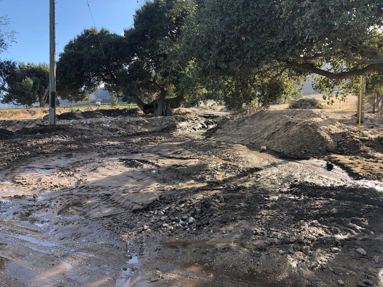
Debris/Mud Flows and Flooding
The heavy rains lasted for over 24 hours in some areas. The rains saturated the earth and loosened leaves, twigs and low lying debris. Strong winds resulted in some areas receiving power outages. Flooding brought hazardous conditions to roadways, blocking some lanes forcing drivers to find alternate routes. In other cases, the rain moved the earth enough to create minor mud flows leaving organic debris in their wake.
 |
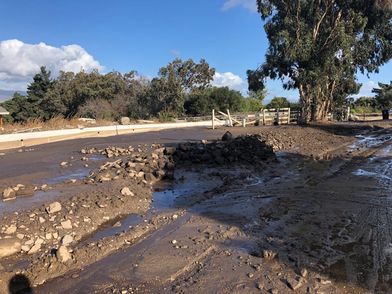 |
| Mud flow observed in Monterey county. Photo by USDA MoCo | Mud flow observed in Monterey county. Photo by USDA MoCo |
Youtube Videos
PRELIMINARY LOCAL STORM REPORT
NATIONAL WEATHER SERVICE SAN FRANCISCO CA
909 AM PDT SUN OCT 31 2021
..TIME... ...EVENT... ...CITY LOCATION... ...LAT.LON...
..DATE... ....MAG.... ..COUNTY LOCATION..ST.. ...SOURCE....
..REMARKS..
0422 AM NON-TSTM WND DMG 2 W MILL VALLEY 37.90N 122.57W
10/24/2021 MARIN CA LAW ENFORCEMENT
MULTIPLE POWER POLES DOWN ON ROADWAY.
PANORAMIC HWY BETWEEN WASHINGTON PARK AND ST
JUDE.
0622 AM FLOOD 1 S NAPA 38.28N 122.30W
10/24/2021 NAPA CA LAW ENFORCEMENT
STREET FLOODING ON GOLDEN GATE DR NEAR STATE
ROUTE 121.
0631 AM NON-TSTM WND DMG 4 WSW CALISTOGA 38.55N 122.65W
10/24/2021 SONOMA CA PUBLIC
TREE DOWN IN ROADWAY. PORTER CREEK RD AT
CALISTOGA RD.
0638 AM NON-TSTM WND DMG 2 SSW HEALDSBURG 38.59N 122.88W
10/24/2021 SONOMA CA LAW ENFORCEMENT
TREE DOWN ON WESTSIDE ROAD NEAR MILL CREEK.
0639 AM NON-TSTM WND DMG 1 W SEBASTOPOL 38.40N 122.85W
10/24/2021 SONOMA CA LAW ENFORCEMENT
TREE DOWN BLOCKING EASTBOUND LANE OF BODEGA
HWY NEAR JEO SAVIO RD.
0646 AM NON-TSTM WND DMG 4 WNW NAPA 38.32N 122.37W
10/24/2021 NAPA CA LAW ENFORCEMENT
LARGE TREE DOWN BLOCKING BOTH LANES ON
PATRICK RD.
0706 AM NON-TSTM WND DMG 2 SE SEBASTOPOL 38.38N 122.80W
10/24/2021 SONOMA CA PUBLIC
TREE DOWN ON POWER LINES. STATE RT 116/
GRAVENSTEIN HWY S.
0708 AM NON-TSTM WND DMG 3 W WOODSIDE 37.43N 122.31W
10/24/2021 SAN MATEO CA LAW ENFORCEMENT
TREE DOWN BLOCKING BOTH LANES. SR 35/SKYLINE
BLVD AT KINGS MOUNTAIN RD.
0800 AM FLOOD 1 SE SAN FRANCISCO 37.77N 122.41W
10/24/2021 SAN FRANCISCO CA PUBLIC
STREET FLOODING. US 101 SOUTH NEAR HARRISON
ST. RELATED VIA SOCIAL MEDIA.
0814 AM NON-TSTM WND DMG 1 W MILLBRAE 37.60N 122.43W
10/24/2021 SAN MATEO CA LAW ENFORCEMENT
TREE DOWN ON ROADWAY. I-280 SOUTH/SR 35
CONNECTOR.
0838 AM NON-TSTM WND DMG 4 SW COTATI 38.29N 122.75W
10/24/2021 SONOMA CA LAW ENFORCEMENT
1 FT DIAMETER TREE DOWN IN ROADWAY. MEACHAM
RD JUST NORTH OF INTERSECTION WITH PEPPER
RD.
0845 AM FLOOD 3 N BRISBANE 37.73N 122.40W
10/24/2021 SAN FRANCISCO CA LAW ENFORCEMENT
STREET FLOODING. SAN BRUNO AVE ONRAMP TO
US101 SOUTH.
0953 AM FLOOD 1 NW PACHECO 38.00N 122.07W
10/24/2021 CONTRA COSTA CA PUBLIC
STREET FLOODING REPORTED IN THE VICINITY OF
BLUM RD, I-680, AND HWY 4.
0957 AM FLOOD 1 N DEER PARK 38.54N 122.47W
10/24/2021 NAPA CA LAW ENFORCEMENT
WATER MOVING OVER ROADWAY. DEER PARK RD AT
GIST RD.
1200 PM NON-TSTM WND DMG 2 ESE DEL MONTE FOREST 36.58N 121.91W
10/24/2021 MONTEREY CA NWS EMPLOYEE
TREE DOWN AT MONTEREY COMMUNITY HOSPITAL.
0131 PM NON-TSTM WND DMG 2 SSW LEXINGTON HILLS 37.14N 121.99W
10/24/2021 SANTA CRUZ CA LAW ENFORCEMENT
TREE DOWN BLOCKING ROAD WAY.
0148 PM FLOOD 2 W ROHNERT PARK 38.35N 122.74W
10/24/2021 SONOMA CA LAW ENFORCEMENT
STREET FLOODING AT INTERSECTION OF ROHNERT
PARK EXPWY AND STONY POINT RD.
0154 PM NON-TSTM WND DMG 8055 FERNWOOD AVE 37.07N 122.08W
10/24/2021 SANTA CRUZ CA LAW ENFORCEMENT
TREE DOWN, HIT RPS GARAGE AND ANOTHER
STRUCTURE.
0255 PM NON-TSTM WND DMG GRAHAM HILL RD 37.01N 122.03W
10/24/2021 SANTA CRUZ CA PUBLIC
TREE DOWN 1125 NB LNS.
0308 PM NON-TSTM WND DMG SCENIC WY 36.97N 122.05W
10/24/2021 SANTA CRUZ CA PUBLIC
LARGE TREE DOWN 1125 LN OF TRAFF.
0347 PM FLOOD 2 NE KENTFIELD 37.97N 122.53W
10/24/2021 MARIN CA EMERGENCY MNGR
PHOTOS FROM SAN RAFAEL OES SHOWING FLOODING
IN DOWNTOWN SAN RAFAEL.
0354 PM FLOOD US-101S MARIN CITY 37.88N 122.51W
10/24/2021 MARIN CA LAW ENFORCEMENT
ROADWAY FLOODING. 1-2 LANES CLOSED.
0415 PM FLOOD GRAYSON CREEK 37.98N 122.07W
10/24/2021 CONTRA COSTA CA TRAINED SPOTTER
CREEK OVERFLOWING ITS BANKS BY AT LEAST A
FOOT.
0425 PM NON-TSTM WND DMG 2 SSW LEXINGTON HILLS 37.14N 121.99W
10/24/2021 SANTA CRUZ CA PUBLIC
TREE ON 1125 MAKING ROAD UNPASSABLE.
0426 PM FLOOD SR 24W - GATEWAY BLVD E 37.87N 122.20W
10/24/2021 CONTRA COSTA CA LAW ENFORCEMENT
ROADWAY FLOODING ON OFFRAMP.
0430 PM NON-TSTM WND DMG 1 N ORINDA 37.90N 122.18W
10/24/2021 CONTRA COSTA CA PUBLIC
TREE DOWN ON TOP OF CAR.
0431 PM FLOOD I680 S / WILLOW PASS R 37.96N 122.05W
10/24/2021 CONTRA COSTA CA LAW ENFORCEMENT
ROADWAY FLOODING.
0509 PM FLOOD 1 WSW COLMA 37.67N 122.47W
10/24/2021 SAN MATEO CA PUBLIC
DELAYED REPORT. STREET FLOODING WITH
STRANDED VEHICLES. I-280 AT SIERRAMONTE EXIT
IN DALY CITY. VIDEO RELAYED VIA SOCIAL
MEDIA.
0510 PM FLOOD 4 W SAN FRANCISCO 37.78N 122.49W
10/24/2021 SAN FRANCISCO CA PUBLIC
1 TO 2 FEET OF WATER ON STREET NEAR 31ST AND
CALIFORNIA INTERSECTION.
0516 PM NON-TSTM WND DMG 3 W GILROY 37.01N 121.63W
10/24/2021 SANTA CLARA CA PUBLIC
TREE DOWN ACROSS ENTIRE RDWY.
0528 PM FLOOD 2 NNW SAN FRANCISCO 37.81N 122.44W
10/24/2021 SAN FRANCISCO CA EMERGENCY MNGR
2 TO 3 FEET OF WATER WHICH IS UP TO THE CURB
ALONG MARINE BLVD.
0603 PM FLOOD 1 E SAN LORENZO 37.68N 122.12W
10/24/2021 ALAMEDA CA LAW ENFORCEMENT
SB I880N FLOODED WITH 1 FT OF RAIN.
0611 PM FLOOD OAKLAND 37.77N 122.23W
10/24/2021 ALAMEDA CA LAW ENFORCEMENT
ROADWAY FLOODING ON I880S 29TH AVE OFF RAMP
AT FRUITVALE.
0712 PM NON-TSTM WND DMG 6 WNW MORGAN HILL 37.15N 121.75W
10/24/2021 SANTA CLARA CA LAW ENFORCEMENT
TREE OR BRANCH IN THE RDWY.
0728 PM FLOOD SCHELLVILLE 38.25N 122.44W
10/24/2021 SONOMA CA LAW ENFORCEMENT
ONE FOOT OF STANDING WATER ON SR-121 AT 8TH
ST. IN SCHELLVILLE.
0747 PM DEBRIS FLOW 2 SSE BEN LOMOND 37.08N 122.07W
10/24/2021 SANTA CRUZ CA LAW ENFORCEMENT
CHP REPORTED A SMALL MUD SLIDE AT QUAIL
HOLLOW RD / MARION AVE.
1023 PM FLOOD 2 NNW SAN MATEO 37.58N 122.33W
10/24/2021 SAN MATEO CA LAW ENFORCEMENT
ROADWAY FLOODING ON US-101N ON RAMP AT
PENINSULA AVE.
1031 PM FLOOD 1 NE CAMPBELL 37.29N 121.94W
10/24/2021 SANTA CLARA CA LAW ENFORCEMENT
ROADWAY FLOODING AT SR-17S AT E HAMILTON AVE
ON RAMP.
1031 PM FLOOD 1 NE CAMPBELL 37.29N 121.94W
10/24/2021 SANTA CLARA CA LAW ENFORCEMENT
ROADWAY FLOODING ON SR-17S AT E HAMILTON AVE
ON RAMP.
1033 PM FLOOD 2 SSW CAMPBELL 37.26N 121.96W
10/24/2021 SANTA CLARA CA LAW ENFORCEMENT
ROADWAY FLOODING ON SR-85N AT THE CONNECTOR
TO NB-17.
1134 PM FLOOD 1 WNW INTERLAKEN - 172 36.96N 121.75W
10/24/2021 SANTA CRUZ CA LAW ENFORCEMENT
3 FT DEEP WATER ON ROADWAY.
1135 PM FLOOD 1 NNE INTERLAKEN 36.96N 121.73W
10/24/2021 SANTA CRUZ CA LAW ENFORCEMENT
RDWY FLOODED 3 FT DEEP IN RDWY.
1136 PM FLOOD 1 NNE MOUNTAIN VIEW 37.41N 122.08W
10/24/2021 SANTA CLARA CA LAW ENFORCEMENT
MULTIPLE LANES HEAVILY FLOODED. 5-10 INCHES
OF STANDING WATER ON SR-85N NEAR RT-101.
1138 PM FLOOD SR85 N / US101 N 37.40N 122.08W
10/24/2021 SANTA CLARA CA PUBLIC
LNS 2-4 ARE HEAVILY FLOODED 5-10 INCHES OF
STANDING WATER // MUTLIPLE VEHS NEAR TC.
1147 PM FLOOD 2 ENE LIVERMORE 37.70N 121.74W
10/24/2021 ALAMEDA CA LAW ENFORCEMENT
I-580W SPRINGTOWN BLVD OFF RAMP FLOODING.
1224 AM FLOOD 2 SE FREMONT 37.51N 121.97W
10/25/2021 ALAMEDA CA LAW ENFORCEMENT
ROADWAY FLOODING.
1224 AM FLOOD 2 SE FREMONT 37.51N 121.97W
10/25/2021 ALAMEDA CA LAW ENFORCEMENT
ROADWAY FLOODING.
0115 AM FLOOD US101 N / SALA RD 36.73N 121.66W
10/25/2021 MONTEREY CA LAW ENFORCEMENT
/ RDWY FLOODED REDUCE SPEED.
0115 AM FLOOD US101 N / SALA RD 36.73N 121.66W
10/25/2021 MONTEREY CA LAW ENFORCEMENT
/ RDWY FLOODED REDUCE SPEED.
0118 AM FLOOD 21020 REDWOOD RD 37.69N 122.07W
10/25/2021 ALAMEDA CA LAW ENFORCEMENT
RDWY FLOODING.
0118 AM FLOOD 21020 REDWOOD RD 37.69N 122.07W
10/25/2021 ALAMEDA CA LAW ENFORCEMENT
RDWY FLOODING.
0313 AM FLOOD 1 SE REDWOOD CITY 37.49N 122.23W
10/25/2021 SAN MATEO CA LAW ENFORCEMENT
STREET FLOODING/STANDING WATER ON MULTIPLE
ROADS IN THE AREA AROUND CONVENTION WAY AND
SB HWY 101.
0313 AM FLOOD 1 SE REDWOOD CITY 37.49N 122.23W
10/25/2021 SAN MATEO CA LAW ENFORCEMENT
STREET FLOODING/STANDING WATER ON MULTIPLE
ROADS IN THE AREA AROUND CONVENTION WAY AND
SB HWY 101.
0421 AM FLOOD 6 SE SAN JOSE 37.24N 121.77W
10/25/2021 SANTA CLARA CA LAW ENFORCEMENT
STREET FLOODING. STATE ROUTE 85 NORTH AT
US101 SOUTH.
0421 AM FLOOD 6 SE SAN JOSE 37.24N 121.77W
10/25/2021 SANTA CLARA CA LAW ENFORCEMENT
STREET FLOODING. STATE ROUTE 85 NORTH AT
US101 SOUTH.
0510 AM FLOOD 5 W MORGAN HILL 37.13N 121.73W
10/25/2021 SANTA CLARA CA LAW ENFORCEMENT
LARGE BOULDER BLOCKING ROADWAY. OAK GLEN AVE
AT UVAS RD.
0510 AM FLOOD 5 W MORGAN HILL 37.13N 121.73W
10/25/2021 SANTA CLARA CA LAW ENFORCEMENT
LARGE BOULDER BLOCKING ROADWAY. OAK GLEN AVE
AT UVAS RD.
0615 AM FLOOD 4 SE SALINAS 36.65N 121.58W
10/25/2021 MONTEREY CA LAW ENFORCEMENT
HARTNELL RD AT ALISAL RD. VEHICLES STRANDED.
0615 AM FLOOD 4 SE SALINAS 36.65N 121.58W
10/25/2021 MONTEREY CA LAW ENFORCEMENT
HARTNELL RD AT ALISAL RD. VEHICLES STRANDED.
0628 AM FLOOD 4 N DAY VALLEY 37.10N 121.87W
10/25/2021 SANTA CRUZ CA LAW ENFORCEMENT
LARGE SECTION OF LOMA PRIETA WAY FLOODED
FROM OVERNIGHT RAINFALL.
0628 AM FLOOD 4 N DAY VALLEY 37.10N 121.87W
10/25/2021 SANTA CRUZ CA LAW ENFORCEMENT
LARGE SECTION OF LOMA PRIETA WAY FLOODED
FROM OVERNIGHT RAINFALL.
0633 AM NON-TSTM WND DMG 5 NE INTERLAKEN 37.00N 121.68W
10/25/2021 SANTA CLARA CA LAW ENFORCEMENT
TREES DOWN ON SR152 WESTBOUND NEAR SPRIG
LAKE.
0633 AM NON-TSTM WND DMG 5 NE INTERLAKEN 37.00N 121.68W
10/25/2021 SANTA CLARA CA LAW ENFORCEMENT
TREES DOWN ON SR152 WESTBOUND NEAR SPRIG
LAKE.
0645 AM FLOOD 1 SW KING CITY 36.20N 121.14W
10/25/2021 MONTEREY CA LAW ENFORCEMENT
STREET FLOODING ON US101 S AT BROADWAY ST.
0645 AM FLOOD 1 SW KING CITY 36.20N 121.14W
10/25/2021 MONTEREY CA LAW ENFORCEMENT
STREET FLOODING ON US101 S AT BROADWAY ST.
0657 AM FLOOD 2 WNW AROMAS 36.89N 121.67W
10/25/2021 MONTEREY CA LAW ENFORCEMENT
VEHICLES STRANDED IN WATER/MUD. SAN JUAN RD
NEAR MURPHY HILL RD.
0657 AM FLOOD 2 WNW AROMAS 36.89N 121.67W
10/25/2021 MONTEREY CA LAW ENFORCEMENT
VEHICLES STRANDED IN WATER/MUD. SAN JUAN RD
NEAR MURPHY HILL RD.
0704 AM NON-TSTM WND DMG 2 SW MORAGA TOWN 37.82N 122.15W
10/25/2021 CONTRA COSTA CA LAW ENFORCEMENT
TREE DOWN IN ROADWAY. ALSO ROCKS AND DEBRIS
IN THE VICINITY OF PINEHURST RD AND CANYON
RD.
0706 AM NON-TSTM WND DMG 12 WSW CARMEL VALLEY VI 36.40N 121.90W
10/25/2021 MONTEREY CA LAW ENFORCEMENT
POWER LINES DOWN IN ROADWAY. PALO COLORADO
RD AT STATE ROUTE 1.
0706 AM NON-TSTM WND DMG 12 WSW CARMEL VALLEY VI 36.40N 121.90W
10/25/2021 MONTEREY CA LAW ENFORCEMENT
POWER LINES DOWN IN ROADWAY. PALO COLORADO
RD AT STATE ROUTE 1.
0725 AM FLOOD 2 ENE LUCAS VALLEY-MARI 38.04N 122.54W
10/25/2021 MARIN CA LAW ENFORCEMENT
STREET FLOODING. STANDING WATER ON ROADWAY.
US101 N OFF-RAMP TO NAVE DR.
0730 AM NON-TSTM WND DMG 3 SE DEL MONTE FOREST 36.56N 121.91W
10/25/2021 MONTEREY CA LAW ENFORCEMENT
TREE DOWN ON ROADWAY. OUTLOOK DRIVE.
0730 AM NON-TSTM WND DMG 3 SE DEL MONTE FOREST 36.56N 121.91W
10/25/2021 MONTEREY CA LAW ENFORCEMENT
TREE DOWN ON ROADWAY. OUTLOOK DRIVE.
0730 AM FLOOD 1 SSW SAN RAFAEL 37.96N 122.51W
10/25/2021 MARIN CA LAW ENFORCEMENT
STREET FLOODING. SB US101 FROM I-580 TO
TAMALPAIS.
0730 AM FLOOD 1 SSW SAN RAFAEL 37.96N 122.51W
10/25/2021 MARIN CA LAW ENFORCEMENT
STREET FLOODING. SB US101 FROM I-580 TO
TAMALPAIS.
0830 AM NON-TSTM WND DMG NOVATO 38.09N 122.56W
10/25/2021 MARIN CA LAW ENFORCEMENT
LARGE HARDWOOD TREE UPROOTED. BRANCHES DOWN
AND MINOR STREET FLOODING. ALL WITHIN THE
CITY OF NOVATO. RELAYED VIA SOCIAL MEDIA.
0830 AM NON-TSTM WND DMG NOVATO 38.09N 122.56W
10/25/2021 MARIN CA LAW ENFORCEMENT
LARGE HARDWOOD TREE UPROOTED. BRANCHES DOWN
AND MINOR STREET FLOODING. ALL WITHIN THE
CITY OF NOVATO. RELAYED VIA SOCIAL MEDIA.
0840 AM NON-TSTM WND DMG 4 W GLEN ELLEN 38.37N 122.62W
10/25/2021 SONOMA CA LAW ENFORCEMENT
TREE DOWN ON SONOMA MOUNTAIN RD BETWEEN
SONOMA RIDGE AND ZACHARY LANE.
0840 AM NON-TSTM WND DMG 4 W GLEN ELLEN 38.37N 122.62W
10/25/2021 SONOMA CA LAW ENFORCEMENT
TREE DOWN ON SONOMA MOUNTAIN RD BETWEEN
SONOMA RIDGE AND ZACHARY LANE.
0900 AM DEBRIS FLOW 19 S CARMEL VALLEY VILL 36.21N 121.74W
10/25/2021 MONTEREY CA DEPT OF HIGHWAYS
SB LANES OF HWY 1 CLOSED NEAR GRIMES CANYON
IN THE BIG SUR AREA DUE TO A ROCKSLIDE.
RELAYED VIA SOCIAL MEDIA.
0900 AM DEBRIS FLOW 19 S CARMEL VALLEY VILL 36.21N 121.74W
10/25/2021 MONTEREY CA DEPT OF HIGHWAYS
SB LANES OF HWY 1 CLOSED NEAR GRIMES CANYON
IN THE BIG SUR AREA DUE TO A ROCKSLIDE.
RELAYED VIA SOCIAL MEDIA.
0904 AM FLOOD 2 SSE PLEASANT HILL 37.93N 122.06W
10/25/2021 CONTRA COSTA CA LAW ENFORCEMENT
STREET FLOODING. OAK RD JUST SOUTH OF ONRAMP
TO I-680.
0904 AM FLOOD 2 SSE PLEASANT HILL 37.93N 122.06W
10/25/2021 CONTRA COSTA CA LAW ENFORCEMENT
STREET FLOODING. OAK RD JUST SOUTH OF ONRAMP
TO I-680.
0911 AM NON-TSTM WND DMG 5 ESE BODEGA BAY 38.30N 122.95W
10/25/2021 MARIN CA LAW ENFORCEMENT
TREE DOWN BLOCKING ROADWAY. VALLEY FORD
FRANKLIN SCHOOL RD SOUTH OF ESTERO RD.
0911 AM NON-TSTM WND DMG 5 ESE BODEGA BAY 38.30N 122.95W
10/25/2021 MARIN CA LAW ENFORCEMENT
TREE DOWN BLOCKING ROADWAY. VALLEY FORD
FRANKLIN SCHOOL RD SOUTH OF ESTERO RD.
0924 AM FLOOD 3 SW WINDSOR 38.51N 122.84W
10/25/2021 SONOMA CA LAW ENFORCEMENT
WATER ON ROADWAY. VEHICLE STRANDED. MARK
WEST STATION RD AT STARR RD.
0924 AM FLOOD 3 SW WINDSOR 38.51N 122.84W
10/25/2021 SONOMA CA LAW ENFORCEMENT
WATER ON ROADWAY. VEHICLE STRANDED. MARK
WEST STATION RD AT STARR RD.
0210 PM NON-TSTM WND DMG 1 ENE ELKHORN 36.82N 121.69W
10/25/2021 MONTEREY CA LAW ENFORCEMENT
PINE TREE DOWN ACROSS ROADWAY ON PARADISE
RD.
0210 PM NON-TSTM WND DMG 1 ENE ELKHORN 36.82N 121.69W
10/25/2021 MONTEREY CA LAW ENFORCEMENT
PINE TREE DOWN ACROSS ROADWAY ON PARADISE
RD.
&&
$$
|
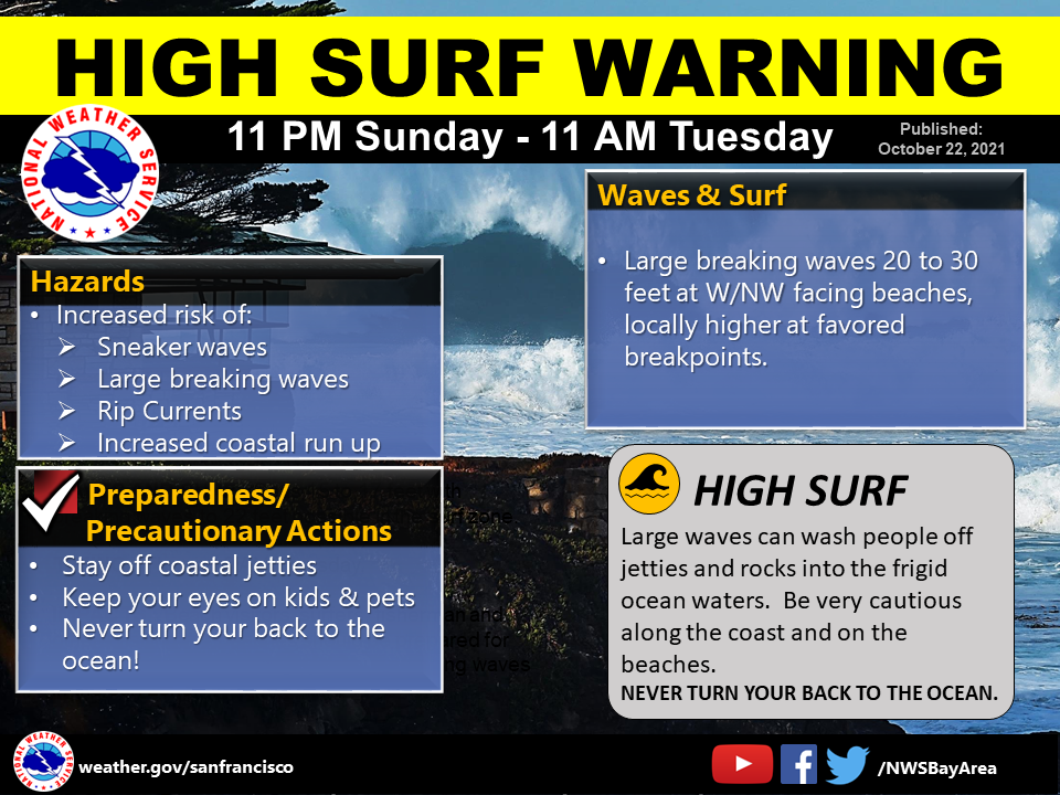
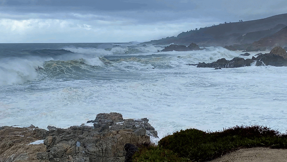
Large Swell Arrived with the Storm
Buoys situated along the coast reported significant wave set heights of around 30 feet along and in the wake of the storm, with peak individual wave heights of 50 to 60 feet. An early season high surf warning was in effect as these energetic, large waves crashed into our coastline and overran many of our west to northwest facing beaches.
Photo by NWS Employee
 |
 |
| A High Surf Warning was issued for the risk of large breaking waves. |
Large breaking waves at Garrapata State Park. Photo by NWS Employee |
 |
Media use of NWS Web News Stories is encouraged! Please acknowledge the NWS as the source of any news information accessed from this site. |
|


 Follow us on YouTube