
Severe thunderstorms are expected across portions of the Southeast and Carolinas today where a Slight Risk (Level 2 of 5) has been issued. A Slight Risk Excessive Rainfall Outlook (Level 2 of 4) has been issued for part of the northern Gulf Coast today due to the threat of flash, urban, and riverine flooding. Read More >
High Wind Derecho Event of May 2, 2007
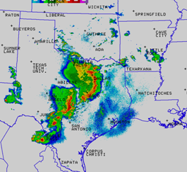
Above: Regional radar mosaic at 7:12 pm on May 2
What is a derecho?
A derecho is a widespread and long-lived windstorm that is associated with a fast-moving band of showers and thunderstorms. The name is a Spanish word which means "direct" or "straight".
For more information on derechos, visit http://www.spc.noaa.gov/misc/AbtDerechos/derechofacts
Atmospheric Conditions...
A moist and unstable atmosphere had been in place across the region for several days. By the afternoon hours, temperatures warmed into the mid to upper 70s, with dewpoints ranging from 67-69F. A potent upper level storm system lifted out of New Mexico and into west Texas, providing large scale lift across the region.
Ahead of the upper storm system, two areas of enhanced lift helped trigger clusters of strong to severe thunderstorms during the afternoon.
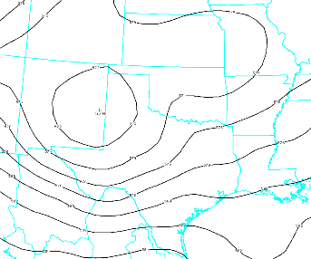
Below: NAM80 00hr Depiction of 500mb Heights at 7 pm May3. An upper level storm system, marked by the "L", was centered over eastern New Mexico and the Texas Panhandle.
Severe Weather Marches Across Texas...
Two complexes of severe thunderstorms developed across western and south central Texas. These complexes, also known as Mesoscale Convective Systems, were likely driven, in part, by bands of stronger winds aloft in the mid levels of the atmosphere.
A small line of thunderstorms, oriented west to east, developed out ahead of the thunderstorm complex approaching Dallas/Fort Worth. These small thunderstorms quickly became mini-supercells, or rotating storms capable of producing tornadoes. Several reports of funnel clouds, as well as a few reports of brief, weak tornadoes were reported in Johnson County, near Cleburne, as well as northern portions of the county, south of Burleson. However, no damage was reported with these tornadoes.
Right: KFWS 0.5 degree radar reflectivity from 5:27 pm on May 2.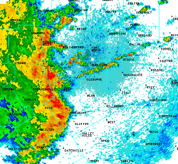
As the evening progressed, the approaching severe thunderstorm complexes took on a bow echo shape in radar reflectivity. Bow echoes occur when strong winds aloft are driven downward toward the surface and push precipitation ahead of the main line of thunderstorms. In the center of the bow, or apex, the strongest winds typically reach the surface.
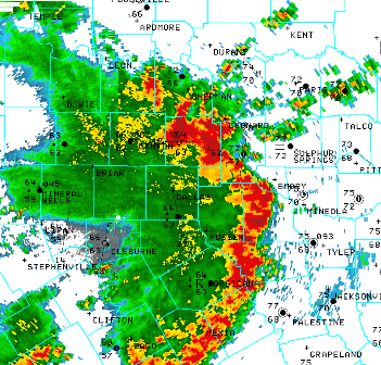
Above: KFWS 0.5 degree radar reflectivity from 7:57 pm on May 2.
Note the observation in Collin County, at the McKinney airport reading a wind gust of 62 kts (71 mph) on the 8 pm observation.
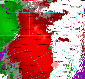
Above: KFWS 0.5 degree radar base velocity from 6:59 pm on May 2. Note the bright red shading (outbound velocities) in west central Dallas County...to Desoto...to near Ferris in Ellis County. The brightest red just southwest of Dallas indicates velocities of 90 kts (104 mph) above the surface. However, a broad area of 75-80 kts (86-92 mph) extends from southwest Dallas County into Northeast Ellis County.
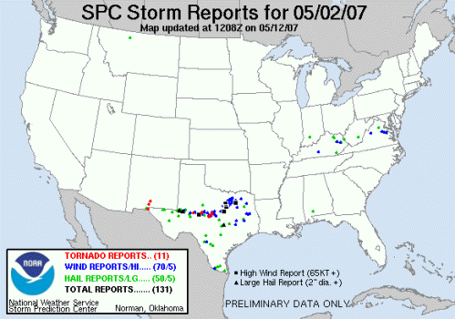
Above: Map of storm reports from May 2 courtesy of the Storm Prediction Center. Notice all the high wind reports (annotated by black squares) were located in north Texas. The high wind reports are those with speeds in excess of 65kts (75 mph). Blue circles indicate wind reports greater than 58 mph and less than 75 mph. The bulk of these reports are located across Texas.
Here is a list of wind reports from north Texas:
Comanche County:
423 PM Estimated 60 mph 8 miles west of Comanche
436 PM Estimated 60 mph Comanche
Bosque County:
523 PM Estimated 80 mph Meridian
Hood County:
548 PM Measured 58 mph Granbury
Johnson County:
548 PM Estimated 80+ mph 3 miles south of Godley
605 PM Estimated 80 mph Cleburne
625 PM Measured 60 mph Cleburne
Tarrant County:
620 PM Estimated 75 mph 2 miles south of Benbrook
645 PM Estimated 60 mph 3 miles south of Keller
651 PM Measured 60 mph Arlington Airport
Dallas County:
654 PM Measured 66 mph Lockheed Martin (Grand Prairie)
714 PM Measured 61 mph Dallas Executive Airport
Collin County:
730 PM Estimated 75, Gust to 80 mph Plano
731 PM Measured 68 mph Plano
803 PM Measured 71 mph McKinney Airport
Kaufman County:
730 PM Estimated 90-100 mph Terrell
Henderson County:
740 PM Estimated 80-100 mph 1 mile southwest of Payne Springs
Hopkins County:
846 PM Measured 59 mph Sulphur Springs
Milam County:
900 PM Estimated 70+ mph Rockdale


 Follow us on YouTube