A significant heat wave is underway for the Intermountain West, Northern Plains, and Upper Great Lakes, peaking in intensity through midweek and lingering across parts of the Northern Plains and Midwest until this weekend. In southwest Texas, excessive rainfall may bring a risk for potentially life-threatening flash and arroyo flooding through Thursday. Read More >
NOAA Weather Radio All Hazards (NWR) is a nationwide network of radio stations broadcasting continuous weather information directly from the nearest National Weather Service office. NWR broadcasts official Weather Service warnings, watches, forecasts and other hazard information 24 hours a day, 7 days a week.
Working with the Federal Communication Commission's (FCC) Emergency Alert System, NWR is an "All Hazards" radio network, making it your single source for comprehensive weather and emergency information. In conjunction with Federal, State, and Local Emergency Managers and other public officials, NWR also broadcasts warning and post-event information for all types of hazards – including natural (such as earthquakes or avalanches), environmental (such as chemical releases or oil spills), and public safety (such as AMBER alerts or 911 Telephone outages).
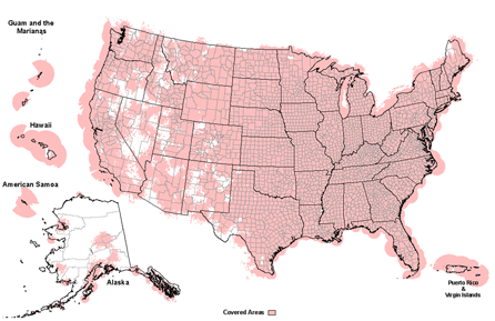
Known as the "Voice of NOAA's National Weather Service," NWR is provided as a public service by the National Oceanic and Atmospheric Administration (NOAA), part of the Department of Commerce. NWR includes more than 1000 transmitters, covering all 50 states, adjacent coastal waters, Puerto Rico, the U.S. Virgin Islands, and the U.S. Pacific Territories. NWR requires a special radio receiver or scanner capable of picking up the signal. Broadcasts are found in the VHF public service band at these seven frequencies (MHz):
Click on notice title to see more or less details.
This information was current on:
NOAA Weather Radio All Hazards Coverage