|
When cooler conditions begin arriving in Deep South Texas in October and November, is is a good time to review potential impacts from winter weather hazards that affect the area, mainly in December and January, but sometimes extending into February as well.
Unlike most of Texas, where cold fronts sweep sub freezing air masses on gusty northerly winds and can produce an occasional diet of low wind chills, frozen ground, and wintry precipitation - ranging from ice pellets and frozen rain in south, central, and East Texas to powdery snow in West Texas and the Panhandle, "winter" in the Valley is fleeting and relatively gentle. However, residents shouldn’t be fooled; the near-tropical climate of Deep South Texas can quickly make what would be a more marginal event farther north into a critical hazard for people and plants alike here.
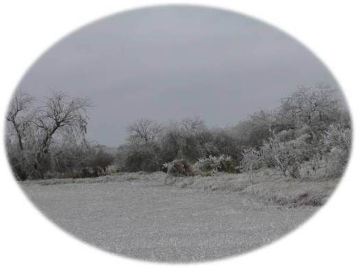
This was exactly what happened between February 2nd and 4th, 2011, when an arctic front brought frigid temperatures in the 20s and 30s on Groundhog Day, followed by an upper level disturbance which provided just enough lift to produce light freezing and frozen precipitation. The ice storm ravaged the Lower and Mid Valley with up to 1 1/2 inches of accretion on trees, signs, and power lines on the 3rd and 4th. Flora impacts were felt well after the storm; nearly Emperor Palm fronds were killed (as were a large number of younger trees), hundreds of tropical plants were damaged, and local citrus groves suffered from the combination of the freeze followed by warm to hot and dry weather from March through September of 2011. The drought didn’t stop there; the winter of 2011/2012 began with some promise with December rains, and was followed by an active spring 2012 with several bouts of scattered thunderstorms. Unfortunately, another hot and dry summer stretched into October, worsening the drought and adding further stress to plants and crops. Long range forecasts for the winter of 2012/2013 indicate uncertainty for temperature and precipitation. There are some indications that a freeze or two could occur between mid December 2012 and mid February 2013. Stay tuned.
For all your winter weather preparedness needs, click here. Want to learn more about winter weather, and meteorology in general? Check out our online weather school! The following paragraphs will describe, in order of likelihood and impact, the winter weather hazards which can affect the Lower Rio Grande Valley and Deep South Texas.
Freezes
When temperatures fall to 32°F (0°C) or lower for a couple hours or more, native plants and crops can be stressed or killed, depending on how low the temperatures fall, the length of the cold, and even the affect of wind on crop protection. Minor freezes occur somewhere in Deep South Texas and the Lower Rio Grande Valley each year, but are typically infrequent. In general, the average first freeze in the Lower Rio Grande Valley occurs around the New Year, and the average last freeze occurs in late January. Freezes can occur as early as November, and as late as March.
On more rare occasions, a hard freeze occurs, defined as at least two hours of temperatures below 28°F (-2.5°C) over a relatively wide area (i.e., half of a county, a large city, etc). During a hard freeze, unprotected cold sensitive plants and crops will be damaged, and some killed outright. The most critical of hard freezes are killing freezes, which feature a long duration of temperatures well below freezing for many hours (generally 10 hours or more), often combined with a continuing northerly wind that does not allow crops to retain necessary surface moisture to help insulate them from the chill.
Notable killing freezes across the Lower Rio Grande Valley, those which wiped out a large number of crops such as citrus and sugar cane, each occurred on or around Christmas. Three notable freezes, in 1981, 1983, and in 1989, brought plummeting temperatures into the upper teens to around 20 in the critical agricultural, with the duration of subfreezing temperatures for most of the overnight hours. The 1983 and 1989 freezes featured consecutive nights of frigid temperatures, increasing the amount of damage to crops and tender vegetation.
Wind Chill
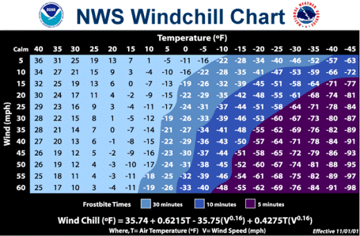
Wind Chill is simply a measure of how cold people and animals feel when outside, based on the rate of heat loss from exposed skin caused by the combination of wind and cold temperatures. The wind chill index calculates the wind speed at an average human "face height", roughly five feet, and incorporates the affect of heat loss from the body to its surroundings during cold and generally breezy to windy days. The near-tropical climate of the Lower Rio Grande Valley likely results in a lower threshold of wind chill impact than a location in temperate regions such as North Texas. The National Weather Service in Brownsville used a best fit model of unusually cold temperatures with anecdotal information from partners in public health and public safety to develop critical wind chill thresholds to best match acclimation of residents; these thresholds are shown in the winter weather hazards tables below. For full details on wind chill, including detailed descriptions and safety measures, click here.
|
|
Ice
Ice, or freezing rain/drizzle, occurs when snow melts into rain well above the earth, then refreezes on contact with sub freezing surfaces on or just above the ground. Ice accretion is extremely dangerous on untreated highways, and has resulted in hundreds of injuries and deaths, nationwide, through the years. February 2011 reminds residents of the Rio Grande Valley that ice storms can happen here. Ice remains a rare occurrence in the Rio Grande Valley, given the lack of persistent frigid air masses needed to keep the ground cold enough for ice to accrete when warm air overruns what remains of any cold surface air. Ice Pellets, or sleet, form when melted snow well above the earth refreezes in a thicker sub freezing layer extending from the ground up a few thousand feet. Sleet, also a dangerous winter weather precipitation hazard, should not be confused with hail, which forms in strong to severe thunderstorms during the spring and summer. Ice pellets are only a few millimeters in diameter, and look like very tiny white, fuzzy balls.
Snow
Snow is the rarest of all winter precipitation types in Deep South Texas and the Lower Rio Grande Valley. In a nutshell, the reason for the lack of observed snow is twofold: Our latitude, and our elevation. It is extremely difficult for a sufficiently cold air mass, extending through the entire depth of the atmosphere, to plunge to the edge of the tropics. While the sinking of cold air, which is "heaviest", to the ground is common, so are pockets of above freezing temperatures in layers somewhat above the surface of the atmosphere, for instance, between 3,000 and 8,000 feet. For these reasons, snow is considered virtually unlikely. However, the atmosphere once in awhile can surprise, and even produce a miracle. On Christmas Eve and early Christmas Morning, 2004, a blanket of snow fell across all of Deep South Texas and the Lower Rio Grande Valley, with a general swath of 2 to 4 inches from Starr and Jim Hogg Counties eastward to the coast!
Winter Weather Definitions for Deep South Texas
The following tables show the necessary conditions for Watches, Warnings, and Advisories, for winter weather events in Deep South Texas and the Rio Grande Valley. Watches, Warnings, or Advisories are issued for the expectation of either 1/2 of a forecast zone’s population, or 1/2 of a forecast zone’s area, will be impacted.
Table 1: Winter Weather Watch Criteria.
| Watch |
Criteria |
|
Definition
|
Issued when conditions are favorable for a hazardous winter weather event to develop and produce high impact and potentially life threatening conditions, generally to begin 24 to 48 hours out from issuance
|
|
Freeze
|
Temperatures ≤32°F or lower for at least two full hours
|
|
Wind Chill
|
Zapata, Jim Hogg, Brooks, Kenedy: ≤15°F, for at least 3 hours in a period (i.e., today, tonight, next day). Elsewhere: ≤20°F. Requires forecast winds ≥10 mph
|
|
Winter Storm
|
Event having at least one hazard meeting or exceeding warning criteria (below) for at least one of the following precipitation elements:
- Snow: ≥1", in 12 hours.
- Sleet: ≥1/2", in 12 hours.
- Combination: Snow, sleet, ice with snow or sleet meeting warning criteria.
Note: snow/sleet accumulation should cover bridges/overpasses.
|
Table 2: Winter Weather Warning Criteria.
| Warning |
Criteria |
|
Definition
|
Issued when conditions are near certain for a hazardous winter weather event to develop and produce high impact and potentially life threatening conditions, generally to begin within the next 24 hours (36 hours in rare cases)
|
|
Freeze
|
Temperatures 32°F or lower for at least two full hours
|
|
Hard Freeze
|
Temperatures 27°F or lower for at least two full hours
|
|
Wind Chill
|
Zapata, Jim Hogg, Brooks, Kenedy: ≤15°F, for at least 3 hours in a period (i.e., today, tonight, next day). Elsewhere: ≤20°F. Requires forecast winds ≥10 mph
|
|
Winter Storm
|
Event having at least one hazard meeting or exceeding warning criteria (below) for at least one of the following precipitation elements:
- Snow: ≥1", in 12 hours
- Sleet: ≥1/2", in 12 hours
- Combination: Snow, sleet, ice with snow or sleet meeting warning criteria.
Note: snow/sleet accumulation should cover bridges/overpasses
|
|
Ice Storm
|
Event having ≥1/8" of Ice accretion, with no time requirement, on trees, power lines, and elevated road surfaces.
|
|
Blizzard
|
Sustained wind or frequent gusts ≥35 mph with falling and or blowing snow, reducing visibility below 1/4 mile for 3 hours or more. Temperatures assumed below 32°F, and snow should accumulate at least 1 inch in 12 hours
|
Table 3: Winter Weather Advisory Criteria.
| Advisory |
Criteria |
|
Definition
|
Issued when conditions are near certain for a hazardous winter weather event to develop and produce significant, but not necessarily life threatening, inconveniences, within the next 24 hours
|
|
Wind Chill
|
Zapata, Jim Hogg, Brooks, Kenedy: ≤25°F, for at least 3 hours in a period (i.e., today, tonight, next day). Elsewhere: ≤30°F. Requires forecast winds ≥10 mph
|
|
Winter Weather
|
Event having at least one hazard meeting advisory (below) for at least one of the following precipitation elements:
- Snow: 1/2 to <1", in 12 hours.
- Sleet: <1/2", in 12 hours.
- Ice: Accretion of any ice (<1/8") causing significant danger to driving or walking
- Combination: Snow, sleet, ice with snow or sleet meeting advisory criteria.
Note: snow/sleet accumulation should coat bridges/overpasses
|
|
| February, 1899: The Great Arctic Outbreak
Perhaps no winter period was more wicked in Texas than that of February 11th through 13th, 1899. The month itself was exceptionally cold, ranking 2nd all time in Brownsville (since records began in 1878). Statewide, incredible arctic cold was felt by Texas standards, lasting a full three days. On February 12th, the lowest temperature ever recorded, -23°F, was observed at Tulia, in the southern Panhandle. Closer to home, record temperatures in the single numbers and lower teens were recorded at Brownsville (12°F on the 13th), Corpus Christi (11°F on the 12th), and Galveston (8°F on the 12th)! Prior to the deep freeze, areas of snow and wind affected portions of central and southeast Texas, as an incredible plunge of artic air helped to "squeeze" moisture out of the atmosphere, beginning in central Texas during the morning and shifting to the southeast Texas coast during the evening. While Deep South Texas and the Lower Rio Grande Valley were not impacted by significant wintry precipitation, a long duration hard freeze, including a period of more than 30 hours where the temperature did not exceed 30°F, occurred. Such a freeze today would extinguish all but the heartiest cold weather plants and crops.
For a detailed article of the Great Arctic Outbreak of February 1899, click here.
|
|


 Follow us on YouTube