April 19-20, 2015 Severe Weather Event
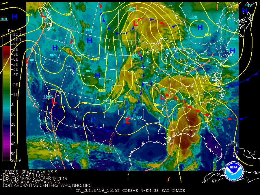
April 19 and 20, 2015 were active in terms of severe weather across north and central Georgia. On Sunday, April 19, 2015 a wedge front lifted northward as a low pressure system tracked across the Tennessee Valley and pushed a weak surface trough across the southeast. This put north and central Georgia in the warm sector, and storms quickly developed Sunday morning. Many of the storms observed on radar this day had rotation in them, but only a few produced tornadoes – one each in Chattahoochee, Sumter, and Laurens Counties. The main damage from the storms on Sunday turned out to be wind damage and was spread across northwest and central Georgia. Another active day occurred on Monday, April 20, 2015, as a cold front pushed through Georgia. The severe storms were confined to north Georgia and were generally just ahead of the cold front. Damage Monday once again included wind damage, but in addition hail was widespread across the northern Atlanta metro area. Reports received by the National Weather Service indicated golfball sized hail was the largest observed on April 20. Additional information will be added as it becomes available.
|
|
 |
| Surface Map from April 19, 2015 | Surface Map from April 20, 2015 |
|
|
 |
| Initial tornado watch from April 19, 2015 | Initial tornado watch from April 20, 2015 |
|
|
 |
| Storm Reports from April 19, 2015 | Storm Reports from April 20, 2105 |
Chattahoochee County:
The tornado moved into Chattahoochee County from Alabama and tracked across the southern portions of Ft. Benning into undeveloped forested areas, lifting about 4 miles ESE of the Fort Benning main gate. Numerous trees were downed. In total the tornado was on the ground approximately 7 minutes in Georgia.
|
|
|
|
 |
| Trees down at Ft. Benning. | Tree uprooted at Ft. Benning. |
|
|
 |
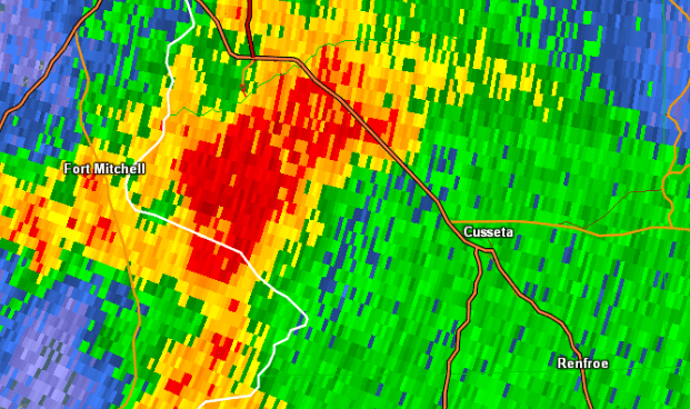
| Reflectivity (1028 AM EDT). | Velocity (1028 AM EDT). |
Sumter County:
A brief EF-1 tornado touched down in southern Sumter County south of Americus. Four large grain silos were completely destroyed with debris thrown about 1/4 mile into an adjacent field. Nearby metal buildings had two doors blown out. Farm equipment and tractors were not damaged. The tornado continued 1.6 miles before lifting, uprooting or snapping a total of 30-40 trees including a large pecan orchard.
|
|
|
|
 |
| Trees snapped with the Sumter County tornado. | Grain silos damaged in the Sumter County tornado. |
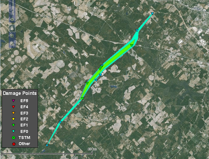
Laurens County:
|
|
An EF-1 tornado with maximum winds of 95 mph and a path length of 11.6 miles tracked across portions of Laurens County during the afternoon on April 19, 2015. It touched down near West Alcorn Farm Road inside the Laurens County line and moved northeast, downing 200 to 300 trees along its track. Structural damage was limited to a shed and a barn which had their metal roofs peeled off. About 40 trees were blown onto the eastbound lane of I-16 before the tornado lifted.
|
|
 |
| Reflectivity (1:24 PM EDT). | Velocity (1:24 PM EDT). |
|
|
 |
| Numerous trees were blown down onto the eastbound lane of I-16. | The metal roof of this storage shed was peeled off by the tornado. |


 Follow us on YouTube