EF-2 Tornado Touches Down in Talbot County on April 27, 2017
Tornado Overview:
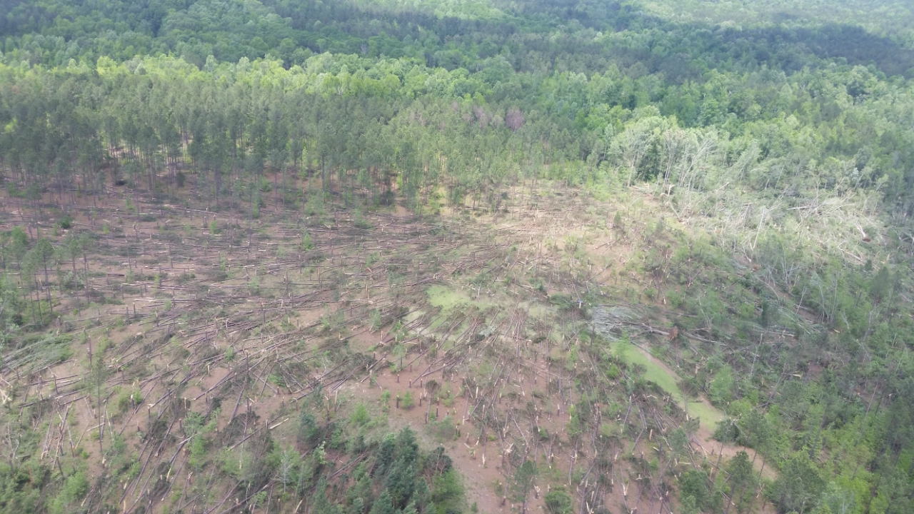
The NWS determined that a long-track, low-end EF-2 tornado occurred across Talbot County on the afternoon of April 27, 2017. The tornado touched down at approximately 1:15 PM EDT, 0.75 miles south of US Highway 80 near the Talbot/Muscogee County line. The tornado initially traversed across a large wooded area causing swaths of minor tree damage. The tornado then traveled across a residential area along Box Springs Road, 0.75 miles south of US Highway 80, causing EF-1 damage to three residential properties including uprooting/snapping a large swath of trees and destroying two barn/farmhouse structures. The tornado then briefly weakened causing sparse damage to trees along an east-northeast path, crossing US Highway 80 at Cusseta Highway around 1:20 PM and passing to the north of Geneva, GA around 1:23 PM. The tornado then began to strengthen considerably around 1:30 PM as indicated by a very pronounced Tornadic Vortex Signature and Tornadic Debris Signature on KJGX radar. At this time, EF-1 damage was indicated by the flattening of a large swath of trees and damage caused at the Junction City Quarry, including a power substation weighing 2-3 tons being moved three feet of its foundation. Along Rock Church Road, the tornado reached a width of at least a quarter mile, blowing over trees along the road and damaging multiple manufactured homes. As the tornado continued along Stalling Lane, large areas of pine trees were snapped, and a mid-sized barn was flattened. The tornado continued to increase in strength, causing EF-2 damage about 1.5 miles north of Junction City at approximately 1:32 PM. Hundreds of trees were identified in wooded areas where nearly all trees were snapped at their bases and very few trees, if any, were left standing. When the tornado crossed Lee Duncan Road, approximately 0.75 miles south-southeast of Ingram Road, it was at its most intense strength with wind speeds estimated to be 120 mph and a maximum path width of 0.4 miles (~700 yards). The tornado then impacted a local residence, knocking over trees onto a home and blowing over a barn with wood posts anchored about a foot into the ground. At this time, approximately 1:36 PM, the TDS could be identified over twenty-thousand feet off the ground by the KJGX radar. The tornado then began to weaken as it continued to the east-northeast over mostly wooded areas, causing more large swaths of snapped trees as it crossed Highway 208. After around 32 minutes on the ground over a 21.5 mile path, the tornado dissipated fairly quickly around the south end of Clayton Matthews Road at approximately 1:47 PM EDT, near the Talbot/Taylor County line.
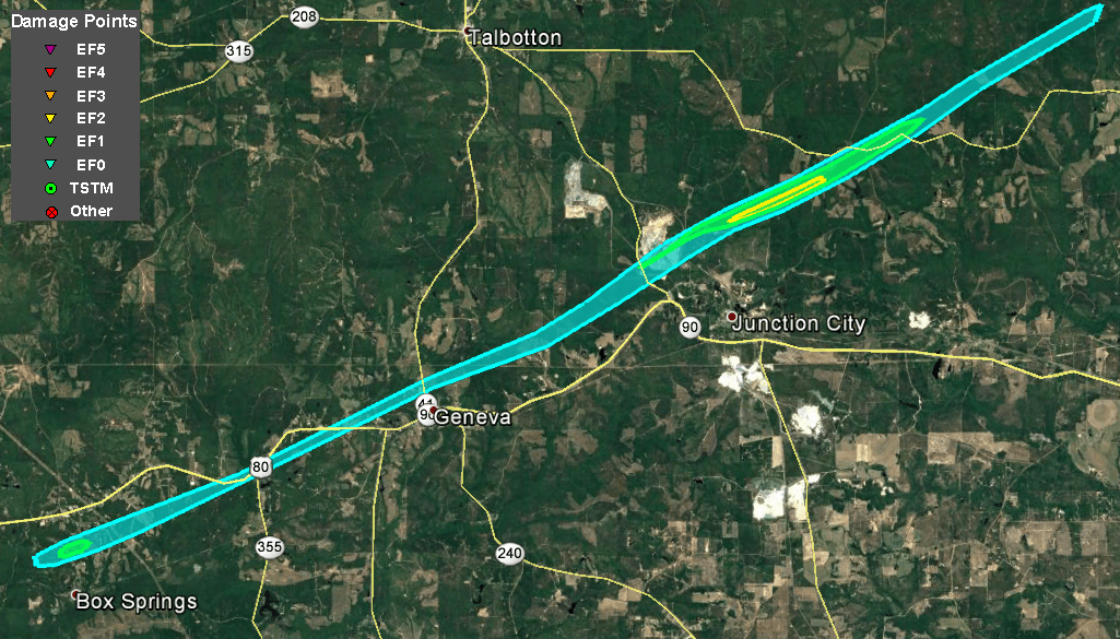 |
| Damage Path - Talbot County |
|
| County |
Rating |
# of Injuries |
KML |
| Talbot |
EF-2 |
0 |
 |
|
| Rating: |
EF-2 |
| Peak Wind: |
120 MPH |
| Path Length: |
21.5 miles |
| Path Width: |
700 yards (0.4 miles) |
| Fatalities: |
0 |
| Injuries: |
0 |
| Start Date: |
Apr. 27, 2017 |
| Start Time: |
1:15 PM EDT |
| Start Lat/Lon: |
32.540892 / -84.673540 |
| End Date: |
Apr. 27, 2017 |
| End Time: |
1:47 PM EDT |
| End Lat/Lon: |
32.682227 / -84.343417 |
|
|
|
|
 |
| Hundreds of trees were snapped or uprooted where the tornado reached its peak EF-2 intensity. |
This barn structure experienced significant EF-2 level damage. |
|

|
 |
| Reflectivity (1:41 PM EDT) |
Velocity (1:41 PM EDT) |
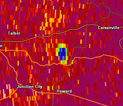 |
| The blue area on the Correlation Coefficient (CC) product shows a very evident debris signature. (1:41 PM EDT) |


 Follow us on YouTube