A cluster of thunderstorms moved through the Mitchell area around 10:45 am CDT on July 30. After the storms moved through the area, a phenomenon called a heat burst occurred. A heat burst occurs when warm air from 10,000 to 20,000 feet above the surface is forced to the ground. Typically when air comes down to the surface with thunderstorms, it is much colder than the air at the surface. However, especially during the late night and morning, very warm air can be forced to the surface if the air reaches the surface without rainfall occurring. When this happens, the temperature will rise as much as 30 degrees, and the dew point will drop by 20 to 30 degrees. Heat bursts are also accompanied by strong to damaging winds. However, unlike many cases with damaging thunderstorm winds, little to no rain will fall when the heat burst occurs. This is because if it were to rain, the air would rapidly cool and moisten due to evaporation.
Temperature, dew point, station pressure and peak wind data (wind gusts) were found at 1 minute intervals from the automated observing unit at the Mitchell, South Dakota airport. This provides an excellent example of the surface conditions associated with a heat burst. Graphs of surface pressure, wind gusts, temperature and dew point are below. The time period covered is from 10:56 am CDT to 11:31 am CDT. The data set begins just after a gust front has gone through Mitchell associated with a severe thunderstorm moving southeast of Mitchell.
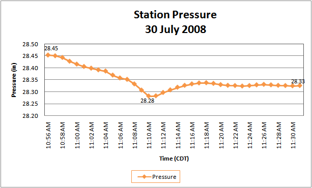
Figure 1. Station pressure from Mitchell, South Dakota from 10:56 am CDT - 11:31 am CDT 30 July 2008.
.gif)
Fig. 2. Peak wind speed from Mitchell, South Dakota.
The station pressure starts at 28.45 in (Figure 1, above). As the mesohigh (an area of high pressure right behind the gust front of a thunderstorm) moves to the east, the pressure falls rapidly. Within 15 minutes, pressure has dropped 0.17 inches (approximately 6 mb) to 28.28 at 11:10 am CDT. This is likely when the mesolow has reached the area. The mesolow is located in an area where air from aloft is subsiding, or sinking, toward the surface. As the mesolow reaches the area, the wind gusted to 55 mph (Figure 2). Notice these gusts began around 11:08 am, about 3 minutes before the mesolow approaches and continues until 11:11 am CDT. This is the same time the pressure fell most rapidly - 0.07 in (~ 2 mb) in 4 minutes.
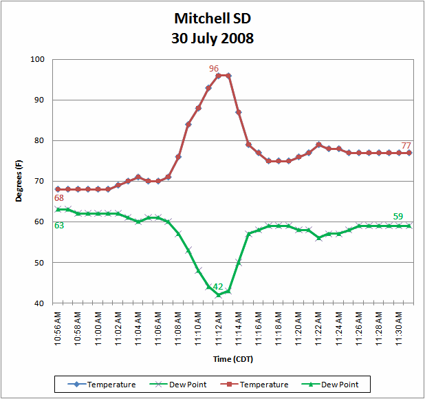
Figure 3. Graph of temperature and dew point for Mitchell, South Dakota.
Following the passage of the gust front, the temperature had fallen into the upper 60s with the dew point in the lower 60s. Shortly after the mesolow passed and the pressure began to rise, the temperature rose rapidly. At 11:07 am CDT, the temperature was 71 degrees, and 5 minutes later the temperature had risen 25 degrees to 96. As the temperature rose, the dew point fell. In the same period of time, between 11:07 and 11:12 am, the dew point fell 18 degrees from 60 down to 42. Another five minutes later the temperature had returned to about the same reading it had been before the outflow boundary went through the city. The dew point, while it rose 17 degrees, was still 14 degrees below what it had been at 10 am CDT before the storms reached Mitchell. By late afternoon, the dew point had returned to the upper 60s.
When the temperature and dew point are reported from the automated weather station, only the 5 minute mean temperature and dew point are used. Therefore, because the temperature was 96 degrees for only 2 minutes, the official high will be 92 degrees and not 96 degrees.
Below is a radar picture from 10:57 am CDT. Notice the storm is approximately 20 miles southeast of Mitchell. Light rain was about to end in Mitchell as the storm continued to move southeast.


 Weather Story
 Weather Map
 Local Radar