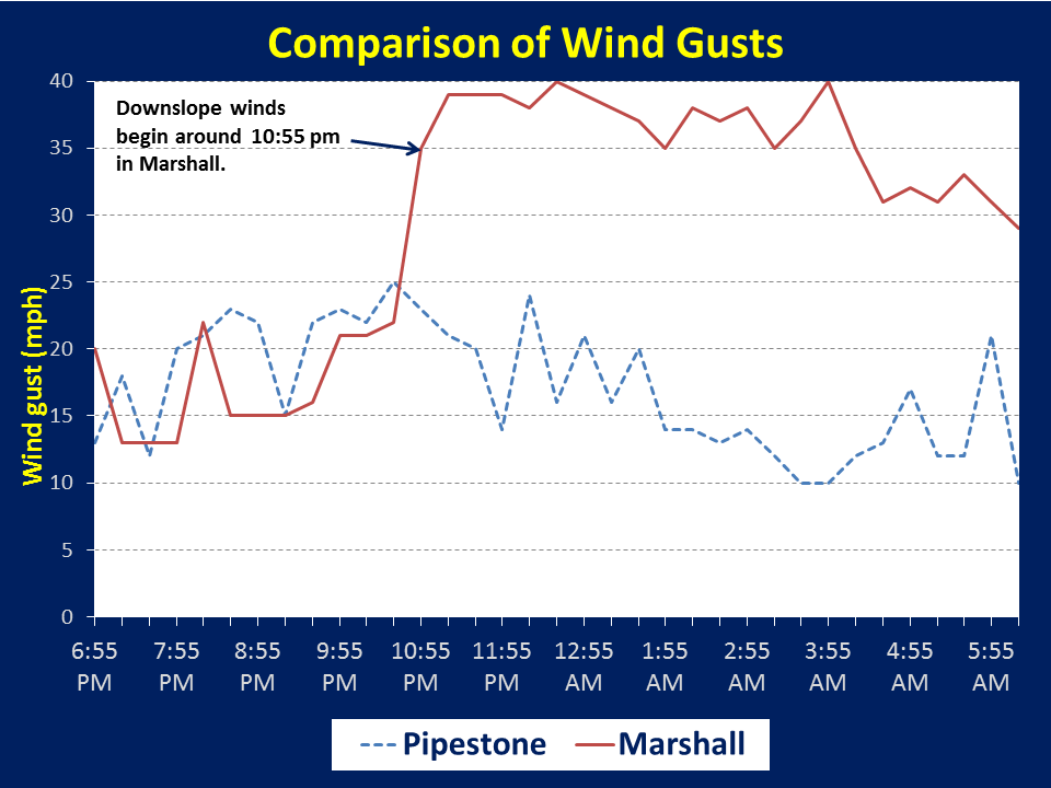
Here are the wind observations from last night comparing Pipestone, Minnesota to Marshall, Minnesota. Notice that the downslope winds began around 10:55 pm and continued through the night. The highest recorded wind speed was 40 mph. See below for the explanation as to why Marshall had stronger winds.
Note: If the wind gust was not available, then the sustained wind speed was used.
Have you wondered why winds are sometimes stronger along and east of the Buffalo Ridge in southwestern Minnesota? In many cases, the strong winds are not where the terrain is the highest but to the east of the ridge. These winds are caused by a phenomenom called downslope winds. They require two meteorological ingredients - a temperature inversion and a southwesterly low level jet.
What is a temperature inversion? A temperature inversion is when the temperature warms with height. This can occur throughout the year but is most common from October through April when there is less sun to warm the surface. Also, during this time, low pressure systems tend to be strong and southerly winds ahead of the low will bring warm air above the surface.
What is a low level jet? A low level jet is when there are strong winds generally less than 4000 ft above the surface. With a typical low level jet, the wind will increase from the surface to 4000 or 5000 feet above the surface and then decrease above that level. In some cases, the strongest winds may be only 1000 or 2000 feet above the surface.
For the Buffalo Ridge in southwestern Minnesota, the wind direction has to be nearly perpendicular to the ridge to develop strong winds. The Buffalo Ridge runs from northwest to southeast from Lake Benton, MN to Wilmont, MN. This means a low level jet with winds from the southwest or northeast are needed for strong downslope winds to develop. A northeasterly low level jet is uncommon over the Northern Plains. In addition, northeast winds will typically bring colder air southward and therefore not allow an temperature inversion to develop. However, a low level jet with southwesterly winds occur frequently over the northern plains - at least a couple of times per month. These winds also bring warmer air northward and help create or strengthen the temperature inversion. This creates the conditions favorable for strong winds east of the Buffalo Ridge.
One last ingredient needed is related to the Earth's surface - a relatively steep slope in terrain. Across Lincoln and Lyon counties in southwest MInnesota, the terrain goes from around 1900 feet near Lake Benton, MN to 1200 feet near Marshall, MN. This decrease in elevation is enough to allow downslope winds to develop. Farther south toward Interstate 90, the elevation only decreases 200-300 feet from west of Worthington to Jackson, MN, and is not adequate for downslope winds to typically develop.
When the low level jet and the temperature inversion are near the same level then conditions become favorable for strong winds. Below is a typical example for the fall and spring. Typically as the sun is setting, temperatures a couple of thousand feet above the surface might be the same or a few degrees warmer than the surface temperatures. At this time, we see similar temperatures on both sides of the Buffalo Ridge. Above the surface, the low level jet begins to develop with winds many times over 30 mph. In the example below, the temperature at the surface is only a few degrees cooler than the air above the surface. The low level jet at this time is around 40 mph. While there are likely winds of 15 to 30 mph, these winds would be seen across the entire area and not focused near the Buffalo Ridge.

As the evening continues, the air at the surface continues to cool due to the loss of sunlight. Wind near the surface will also typically decrease in the evening. While winds may be weakening near the surface, the low level jet usually strengthens. As the low level jet strengthens, warmer air is also coming northward and temperature in many cases will increase above the surface. At the same time, temperatures at the surface cool after sunset. This acts to increase the temperature difference between the surface and aloft which means a stronger temperature inversion.
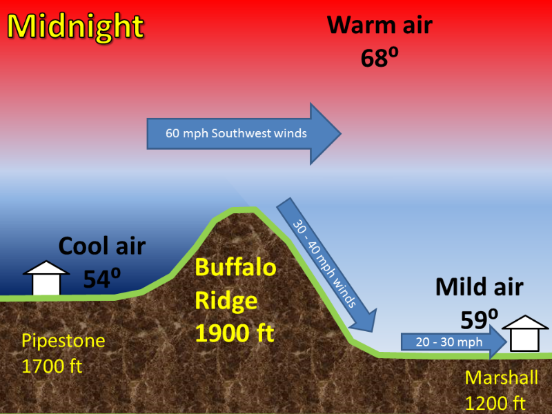
In the image below, we see that the winds with the low level jet have increased to 60 mph. At the same time, temperatures above the surface have warmed a couple of degrees while west of the ridge, temperatures have cooled several degrees. The combination of a strong inversion, a strong level jet and the presence of slope in the terrain to the east of the ridge line allows some of these strong winds to reach the surface. As seen on the image below, the strongest winds are not typically at the top of the ridge but are actually east of the ridge top. The winds will gradually decrease in speed as one moves away from the slope although winds will still gust higher. In this case, winds may gust to 40 mph between the Buffalo Ridge and Marshall, Minnesota. At Marshall Minnesota, the wind gusts are somewhat lighter - from 20 to 30 mph.
These type of wind events occur almost every month of the year east of the Buffalo Ridge - especially in portions of Lyon and Lincoln counties in southwest Minnesota. The strongest wind events tend to be in winter when both the temperature inversion and low level jet are strongest. In mid winter, winds can gust 50 mph or higher east of the Buffalo Ridge with temperatures warming 10 or more degrees overnight. If there is loose snow on the ground, this can even create localized ground blizzards such as occurred near Sisseton, South Dakota on February 3, 2011.


 Weather Story
 Weather Map
 Local Radar
 Follow us on YouTube