
A High Risk (Level 4 of 4) of Excessive Rainfall has been issued for portions of east Texas into western Louisiana today. For weeks, heavy rainfall has fallen across the Gulf coast states so any additional rainfall today will likely lead to life threatening flash flooding. Severe thunderstorms capable of producing large hail, severe winds and tornadoes will also be possible in central Texas. Read More >
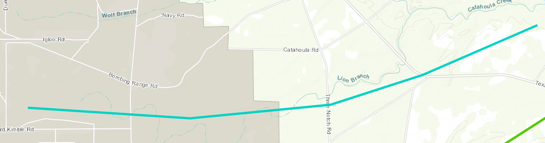
Stennis Space Center, MS Tornado - April 10, 2024
|
Rating:
|
EF-0
|
|
Estimated Maximum Wind:
|
85 mph
|
|
Injuries/Fatalities:
|
None
|
|
Damage Path Length:
|
5.33 miles
|
|
Maximum Path Width:
|
300 yards
|
|
Approximate Start Point/Time:
|
9 miles ENE of Pearl River, LA at 1017 AM CDT
|
|
Approximate End Point/Time:
|
5 miles WSW of Kiln, MS at 1024 AM CDT
|
|
A National Weather Service Damage Assessment Team has surveyed the storm damage in Stennis Space Center, MS. It has been determined the damage was the result of a tornado. The tornado has been rated an EF-0 on the Enhanced Fujita Scale. Damage estimates were consistent with winds of 85 mph. This tornado started fairly large from the start with a swath extending from Leonard Kimble Road and further north along Mainline Road. High resolution satellite imagery indicated the damage path continued eastward where it crossed Texas Flat Road. Branches were broken and a few snapped trees were observed in a generally confluent pattern. The end point for this tornado is estimated based off high resolution satellite NDVI differencing as it interactive with the parent mesovortex and appeared to dissipate. |
|
|


 Follow us on YouTube