
Critical fire weather conditions, severe thunderstorms capable of producing severe wind gusts, large hail, strong tornadoes and heavy rainfall remain on tap for the central U.S. this evening. Flash flooding is also possible for portions of the Plains and Mississippi Valley. Very large hail up to 3 inches in diameter will be possible this evening across western Kansas. Read More >
Information on this webpage is considered preliminary.
April 17-18, 2013 Tornado and Flood Event
Anyone with information that could enhance the record of these storms should contact the National Weather Service Office in Tulsa at 918-838-7838 during business hours or send us an email at: sr-tsa.stormreport@noaa.gov
Event Summary
During the evening of the April 17, 2013 and into the morning of the 18th, severe thunderstorms and flooding occurred across northeast Oklahoma and northwest Arkansas. On the morning of the 17th, a warm front surged north into Kansas and Missouri setting the stage for the severe weather and flooding later in the evening. Thunderstorms developed along the front as it moved into Central and Northeast Oklahoma as a cold front during the afternoon and evening hours of the 17th. As the front moved slowly to the east, storms moved to the northeast along the frontal boundary, leading to flooding as the storms moving repeatedly across the same area.
There were several rounds of thunderstorms across northeast Oklahoma and northwest Arkansas, with a line of severe thunderstorms occurring late in the evening and into the early morning hours. This line of thunderstorms evolved into a bow echo and moved swiftly across northeast OK and northwest AR, producing wind damage, large hail, and several tornadoes. The tornadoes were associated with rather brief circulations that apparently evolved from the interaction of thunderstorms near the apex of the bow with the quasi-stationary frontal boundary. Tornado damage was reported in Broken Arrow, Inola, Salina, Spavinaw, and Butler (near Grove) in northeast Oklahoma. Specific details about these tornadoes can be found below.
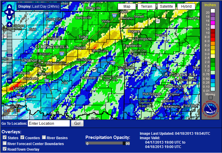
Flooding was widespread across east-central Oklahoma into far northwest Arkansas, where the rainfall amounts were most impressive: 3" to 5" with some isolated reports of up to 7". Several State Highways were impassible due to high water, as well as many smaller city, town, and county roads. The heaviest rain fell over the Deep Fork River and Illinois River basins, causing flooding along Flint Creek near Kansas and the Illinois River near Watts and near Tahlequah.
| 24-hr rainfall measurements >3.50” ending 7am 4/18/13 | |||||||
| Wagoner 4.1ESE, OK | 7.00 | Haskell 2E, OK | 4.99 | Locust Grove 4S, OK | 4.67 | ||
| Kansas 6ESE, OK | 4.66 | Pea Ridge, AR | 4.58 | Little Frock 2NNE, AR | 4.20 | ||
| Bristow 4SSE, OK | 4.12 | West Siloam Springs, OK | 4.06 | Bentonville 0.9NW, AR | 4.00 | ||
| Decatur 2.6ESE, AR | 3.96 | Bentonville 2.8SSW, AR | 3.90 | Porter 3ESE, OK | 3.85 | ||
| Bella Vista 1ESE, AR | 3.80 | Centerton 0.8SW, AR | 3.65 | Inola 6SSW, OK (L&D 18) | 3.60 | ||
| Colcord 4N, OK | 3.56 | Jay 3.3 NNE, OK | 3.50 | ||||
Click on images for larger view in a new window
 |
 |
 |
| 24-hr Rainfall Totals ending at 2pm CDT April 18, 2013 | KINX Reflectivity and Storm Relative Velocity for tornado near Bixby, OK. Radar image valid 11:50pm CDT April 17, 2013 | KINX Reflectivity and Storm Relative Velocity for tornado in Broken Arrow, OK. Radar image valid 12:04am CDT April 18, 2013 |
 |
 |
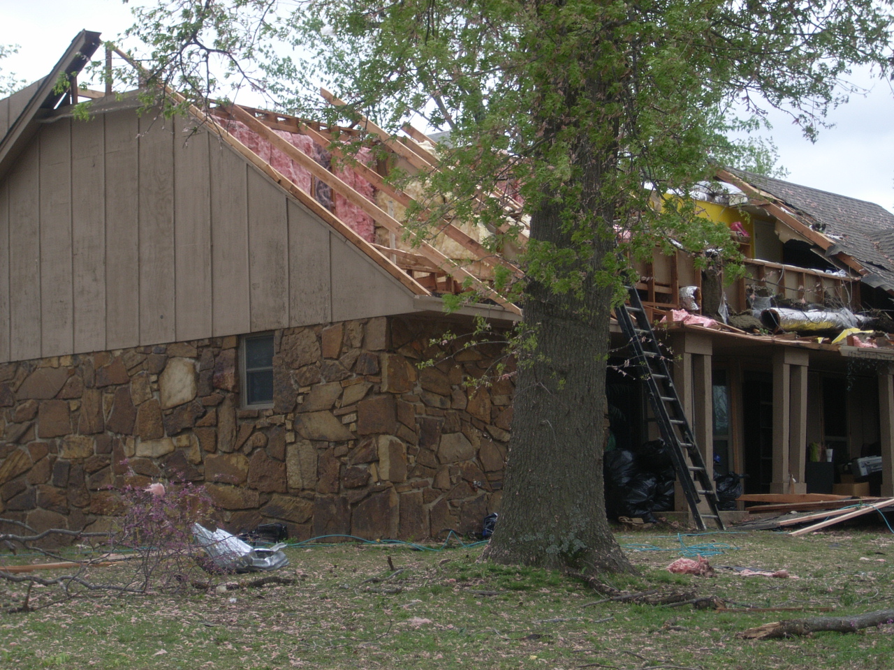 |
| KINX Reflectivity and Storm Relative Velocity for tornado in Inola, OK. Radar image valid 12:34am CDT April 18, 2013 | KINX Reflectivity and Storm Relative Velocity for tornado in Spavinaw, OK. Radar image valid 1:11am CDT April 18, 2013 | Roof Damage in Broken Arrow |
 |
 |
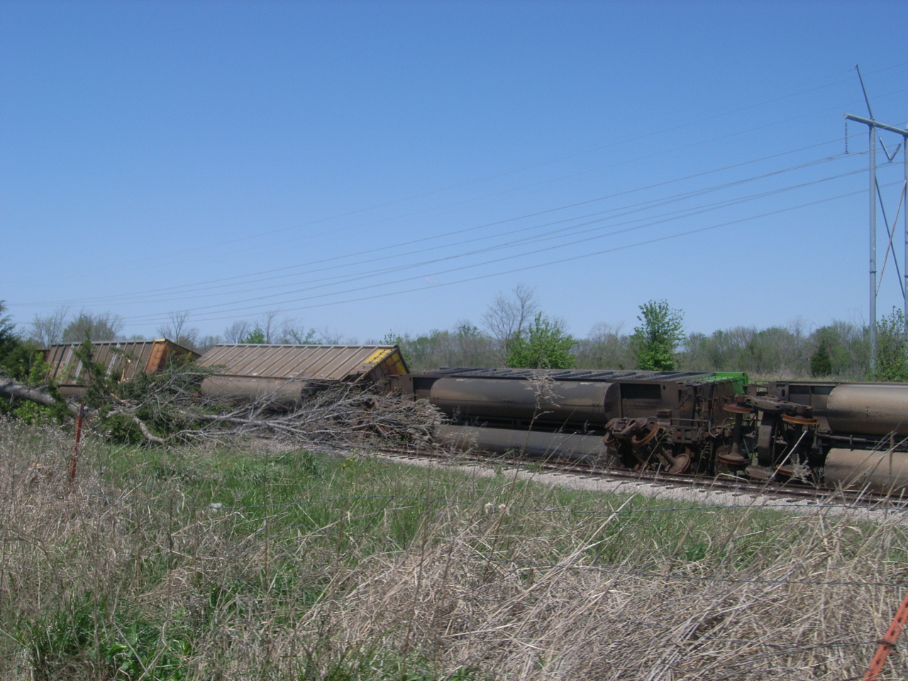 |
| KINX Reflectivity and Storm Relative Velocity for Butler tornado. Radar image valid 1:30am CDT April 18, 2013 | KINX Reflectivity and Storm Relative Velocity for Butler tornado. Radar image valid 1:34am CDT April 18, 2013 | Rail Cars Blown Off Tracks in Inola |
|
Preliminary Information (last updated 9:18 pm CDT 4/22/2013): Liberty Tornado (Tulsa County) Began: 2.4 NW Liberty, OK at 11:50 pm CDT April 17, 2013 Ended: 2.4 NW Liberty, OK at 11:51 pm CDT April 17, 2013 Path Length: 0.5 miles Max Path Width: 50 yards EF Rating: EF-0 with maximum wind speeds of 65-75 mph Survey Summary: A KOTV meteorologist observed this tornado crossing highway 75 just north of 201st street south in southern Tulsa County. The tornado blew a vehicle off the road and onto the center median. It also did some minor tree damage. |
|
Preliminary Information (last updated 9:14 pm CDT 4/19/2013): Broken Arrow Tornado #1 (Tulsa County) Began: 6.0 SSW Broken Arrow, OK at 12:01 am CDT April 18, 2013 Ended: 6.0 SW Broken Arrow, OK at 12:03 am CDT April 18, 2013 Path Length: 1.3 miles Max Path Width: 250 yards EF Rating: EF-0 with maximum wind speeds of 80-85 mph Survey Summary: This tornado damaged a number of homes and snapped numerous large tree limbs. The tornado moved north, and then curved northwest. |
|
Preliminary Information (last updated 9:23 pm CDT 4/19/2013): Broken Arrow Tornado #2 (Tulsa County) Began: 6.6 SW Broken Arrow, OK at 12:03 am CDT April 18, 2013 Ended: 4.6 SW Broken Arrow, OK at 12:05 am CDT April 18, 2013 Path Length: 2.1 miles Max Path Width: 400 yards EF Rating: EF-1 with maximum wind speeds of 90-100 mph Survey Summary: This tornado severely damaged the second story of a permanent home and damaged many others. Some windows in a few homes were blown out. Trees were uprooted and large tree branches were snapped. This tornado moved north-northeast, then curved slightly north. |
|
Preliminary Information (last updated 9:29 pm CDT 4/19/2013): Inola Tornado #1 (Rogers County) Began: 3.9 SW Inola, OK at 12:28 am CDT April 18, 2013 Ended: 3.0 SW Inola, OK at 12:29 am CDT April 18, 2013 Path Length: 0.9 miles Max Path Width: 125 yards EF Rating: EF-0 with maximum wind speeds of 70-75 mph Survey Summary: This tornado badly damaged a barn, downed several trees, and did minor damage to the roof of a home. The tornado traveled northeast. |
|
Preliminary Information (last updated 9:51 pm CDT 4/19/2013): Inola Tornado #2 (Rogers County) Began: 2.2 SW Inola, OK at 12:29 am CDT April 18, 2013 Ended: 1.1 SE Inola, OK at 12:32 am CDT April 18, 2013 Path Length: 1.8 miles Max Path Width: 140 yards EF Rating: EF-1 with maximum wind speeds of 100-110 mph Survey Summary: This tornado overturned several empty rail cars, destroyed a mobile home, and damaged several other homes. The tornado traveled northeast and then more northerly the last half of its existence. |
|
Preliminary Information (last updated 9:29 pm CDT 4/19/2013): Inola Tornado #3 (Rogers County) Began: 0.6 SE Inola, OK at 12:33 am CDT April 18, 2013 Ended: 1.9 ENE Inola, OK at 12:36 am CDT April 18, 2013 Path Length: 1.9 miles Max Path Width: 180 yards EF Rating: EF-1 with maximum wind speeds of 90-95 mph Survey Summary: This tornado damaged the roofs of a number of homes and badly damaged a metal frame building, destroying a smaller outbuilding. This tornado's path is the most complex of the three. The tornado initially moved east-northeast before turning sharply north. Near the end of its existence, the tornado veered toward the east as complex interactions occurred within the broader area of rotation. |
|
Preliminary Information (last updated 3:16 pm CDT 4/20/2013): Salina Tornado (Mayes County, OK) Began: 5.4 NE Chouteau, OK at 12:48 am CDT April 18, 2013 Ended: 2.4 NW Salina, OK at 12:58 am CDT April 18, 2013 Path Length: 6.5 miles Max Path Width: 100 yards EF Rating: EF-1 with maximum wind speeds of 85-95 mph Survey Summary: This tornado tore much of the roof off of an industrial building on highway 69A on the north side of the mid-America industrial complex, destroyed a barn, snapped numerous large tree limbs, and uprooted a couple trees. |
|
Preliminary Information (last updated 9:46 pm CDT 4/19/2013): Spavinaw Tornado (Mayes County, OK) Began: 2.1 SW Spavinaw, OK at 1:07 am CDT April 18, 2013 Ended: 1.4 NE Spavinaw, OK at 1:13 am CDT April 18, 2013 Path Length: 3.5 miles Max Path Width: 350 yards EF Rating: EF-1 with maximum wind speeds of 100-110 mph Survey Summary: This tornado developed in the cyclonic comma head of the bow echo, well behind the initial storm surge and gust front. It developed south of East 440 Road southwest of Spavinaw, snapping and uprooting numerous trees as it approached the town. Numerous homes were damaged, including several mobile homes that were destroyed, the roof of the school was severely damaged, trees and power poles were blown down, and several businesses were damaged as the tornado moved through town. It dissipated south of Highway 20 northeast of town. |
|
Preliminary Information (last updated 9:45 pm CDT 4/19/2013): Butler Tornado (Delaware County, OK) Began: 4.0 E Zena, OK at 1:30 am CDT April 18, 2013 Ended: 7.0 SE Grove, OK at 1:40 am CDT April 18, 2013 Path Length: 8.0 miles Max Path Width: 800 yards EF Rating: EF-2 with maximum wind speeds of 115-125 mph Survey Summary: This tornado developed along the leading edge of the bow echo. It formed just east of Highway 59, south of Highway 127. The most intense stage of this tornado's lifecycle was early on as it produced an 800 yard wide corridor of impressive tree damage when it crossed the 638 Road and severely damaged a permanent home. Numerous trees were snapped and uprooted, power poles were blown down, homes were damaged, and barns were destroyed as the tornado moved northeast. It dissipated about 2 miles west of the Missouri state line, north of East 324 Road. |


 Follow us on YouTube