Winter 2013 - 2014 Highlights
| Jump To: | Temperatures | Precipitation | Drought Progression |
| Tulsa - Averages & Records | Fort Smith - Averages & Records | Fayetteville - Averages & Records | |
| Weather Highlights | Spring 2014 Outlook |
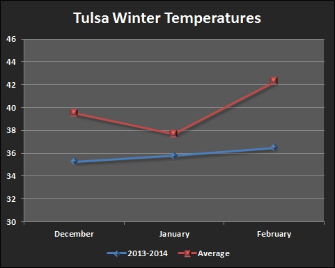
The following line graphs depict the mean temperature for the months of December - February (in blue) along with the expected mean temperature (in red) for Tulsa, OK, Fort Smith, AR and Fayetteville, AR. The mean temperatures were taken from 1980 - 2010.
 |
 |
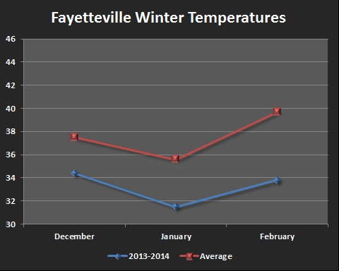 |
The winter months of 2013 - 2014 remained below normal the entire season at all three climate sites. Several bouts of well below normal temperatures during early December, early and late January, along with early and late February made this winter the 12th coldest on record for Tulsa, OK. The same is true for Fort Smith, AR, which ranked 23rd coldest, as well as Fayetteville, AR, which ranked 5th coldest. For Tulsa, OK mean monthly temperatures for December - February were below normal by 4.2°, 1.9°, and 5.8° respectfully. In Fort Smith, AR, the temperatures were below normal by 2.3°, 2.2°, and 4.4° during the months of December - February. Finally, for Fayetteville, AR, the monthly mean temperatures for the winter months of December - February were 3.1°, 4.1°, and 5.9° below normal.
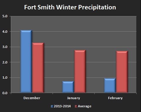
The following bar graphs depict the mean precipitation for the months of December - February (in blue) along with the expected mean precipitation (in red) for Tulsa, OK, Fort Smith, AR and Fayetteville, AR. The mean precipitation amounts were taken from 1980 - 2010.
 |
 |
 |
The winter season started out with fairly normal amounts of precipitation falling during the month of December, with Tulsa, OK receiving slightly below normal rainfall (-0.71"), and both Fort Smith, AR and Fayetteville, AR receiving above normal rainfall with +0.81" and +0.86" respectfully. Once we got into January, however, the area received very little precipitation, with Tulsa, OK ending the month with only 0.13" of rain, which is 1.53" below normal. This was the 4th driest January on record for Tulsa, OK. Fort Smith, AR and Fayetteville, AR both received a little bit more precipitation, but still fell well below normal with only 0.79" recorded in Fort Smith, AR, which is 2.02" below normal, and 1.64" recorded in Fayetteville, AR, which is 1.20" below normal. February continued the dry spell with all three climate sites receiving less than 37% of their normal monthly rainfall. Tulsa, OK only received 0.32" (-1.53"), Fort Smith, AR only received 0.98" (-1.78"), and Fayetteville, AR only received 0.84" (-1.97"). These very dry conditions during the winter lead to D-0 and D-1 drought conditions developing across eastern Oklahoma and northwest Arkansas by the end of February.
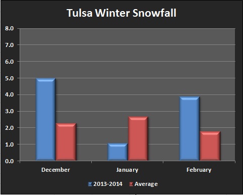
The following bar graphs depict the mean snowfall for the months of December - February (in blue) along with the expected mean snowfall (in red) for Tulsa, OK, Fort Smith, AR and Fayetteville, AR. The mean snowfall amounts were taken from 1980 - 2010.
 |
 |
 |
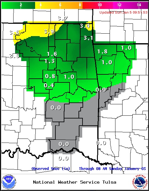
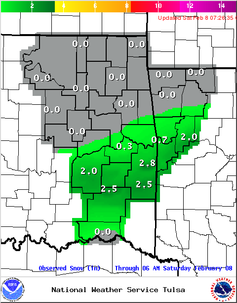
While precipitation amounts were below normal for much of the winter months, snowfall amounts, on the other hand, were above normal. The below normal temperatures helped to change what little precipitation fell into sleet, snow, and ice. December started out the winter with several inches of snow falling, mainly during the December 6th snowfall event. Tulsa, OK received 4.2" of snow that day, with a total of 5.0" for the month. Fort Smith, AR received 4.9" on December 6th, with 5.0" for the month. Fayetteville, AR received 6.7" on December 6th, with a total of 7.0" for the month. All three climate sites set new daily snowfall records for the snow they received on December 6th. Normal, or below normal amounts of snow fell during the month of January, with Tulsa, OK receiving 1.1", Fort Smith, AR receiving only a trace, and Fayetteville, AR receiving 1.9". Above normal snowfall occurred again during February, with most of the snow falling on February 2nd. Monthly totals include 3.9" in Tulsa, OK, 5.2" in Fort Smith, AR and 5.2" in Fayetteville, AR.
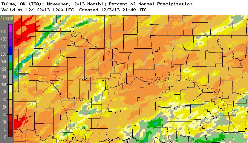
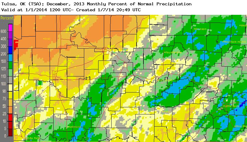
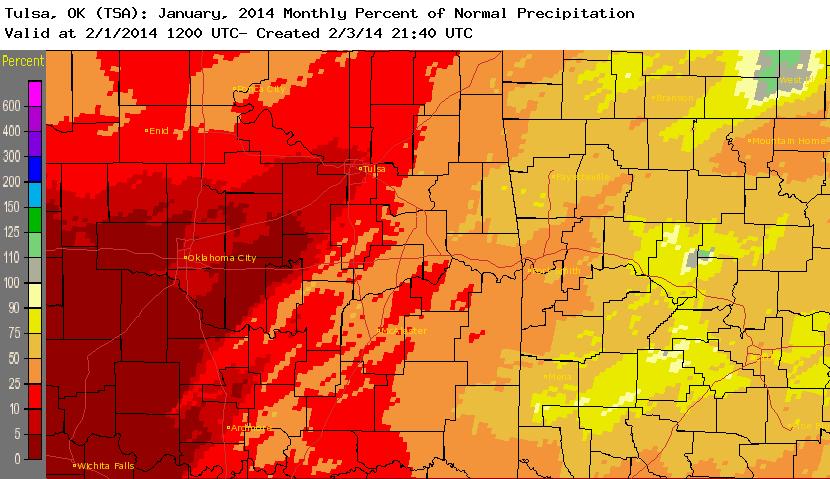
The following chart depicts the amount of precipitation that fell leading up to, and during the winter months of 2013 - 2014, and how that impacted the current drought across the area. The first image is the amount of rainfall that fell during the month (observed precipitation). The second image is the percentage of expected rainfall that fell during the month (percent of normal). The third image is the state of drought near the end of that month (drought progression).
| Observed Preciptation | Percent of Normal | Drought Progression | |
| November 2013 |  |
 |
November 26, 2013 |
| December 2013 |  |
 |
December 31, 2013 |
| January 2014 |  |
 |
January 28, 2014 |
| February 2014 | 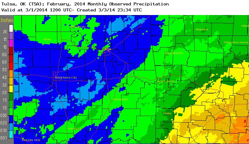 |
 |
February 25, 2014 |
At the end of fall 2013, eastern Oklahoma and northwest Arkansas were for the most part drought free. There were a couple small areas of D-0 drought, or "abnormally dry" conditions, across southern Rogers, southern Mayes, and northern Wagoner Counties, as well as over Choctaw County. Other than locations along and north of highway 44, normal amounts of precipitation fell during the month of December. Drought conditions remained neutral during this time, with the two areas of D-0 "abnormally dry" areas remaining the same. Below normal amounts of precipitation during the month of January expanded the D-0 "abnormally dry" area across northeast Oklahoma, mainly along and north of Highway 44. Well below normal precipitation again during February expanded the D-0 "abnormally dry" conditions to all of eastern Oklahoma and northwest Arkansas, and caused D-1 "moderate drought" conditions to develop over locations along and north of Highway 44 and across Choctaw County in southeast Oklahoma.
Below are tables for Tulsa, OK, Fort Smith, AR and Fayetteville, AR with their monthly averages and records for temperatures and precipitation for the winter months of December - February, along with the winter seasonal average. Below the tables are the daily temperature and precipitation records set during the season.
Tulsa:
| Tulsa, OK |
Average Temperature |
Departure from Normal |
Rank | Record |
| December 2013 | 35.3°F | -4.2°F | 14th coldest | 26.7°F in 1983 |
| January 2014 | 35.8°F | -1.9°F | 39th coldest | 21.7°F in 1918 |
| February 2014 | 36.5°F | -5.8°F | 14th coldest | 27.5°F in 1905 |
| Winter Season 2013-2014 | 35.8°F | -3.9°F | 12th coldest | 30.4°F in 1978-1979 |
* December 5, set a new lowest maximum temperature record of 30 degrees (old record was 32 degrees in 1910,1972,1992).
* January 6, set a new lowest minimum temperature record of -2 degrees (old record was 0 degrees in 1912).
* January 6, tied the lowest mean temperature record of 8 degrees (other record in 1912).
* February 6, set a new lowest maximum temperature record of 20 degrees (old record was 21 degrees in 1989).
* February 6, set a new lowest mean temperature record of 14 degrees (old record was 15 degrees in 1989).
* February 7, tied the lowest maximum temperature record of 27 degrees (other records in 1971,1985).
| Tulsa, OK | Precipitation | Departure from Normal | Rank | Record |
| December 2013 | 1.78" | -0.71" | 74th driest | 0.00" in 1889/1900 |
| January 2014 | 0.13" | -1.53" | 4th driest | 0.00" in 1986 |
| February 2014 | 0.32" | -1.53" | 11th driest | 0.00" in 1895/1904 |
| Winter Season 2013-2014 | 2.23" | -3.77" | 6th driest | 1.59" in 2005-2006 |
* No daily precipitation records were set during the winter season in Tulsa, OK.
| Tulsa, OK | Snowfall | Departure from Normal | Rank | Record |
| December 2013 | 5.0" | +2.7" | 13th snowiest | 11.4" in 2000 |
| January 2014 | 1.1" | -1.6" | 49th driest | 12.7" in 1979 |
| February 2014 | 3.9" | +2.1" | 26th snowiest | 22.5" in 2011 |
| Winter Season 2013-2014 | 10.0" | +3.2" | - | - |
* December 6, set a new snowfall record of 4.2" (old record was 0.3" in 1969).
| Fort Smith, AR | Average Temperature | Departure from Normal | Rank | Record |
| December 2013 | 39.0°F | -2.3°F | 21st coldest | 28.9°F in 1983 |
| January 2014 | 37.2°F | -2.2°F | 38th coldest | 25.6°F in 1979 |
| February 2014 | 39.8°F | -4.4°F | 25th coldest | 31.5°F in 1905 |
| Winter Season 2013-2014 | 38.6°F | -3.0°F | 23rd coldest | 33.1°F in 1978-1979 |
* January 6, set a new lowest maximum temperature record of 19 degrees (old record was 22 degrees in 1884).
* January 6, set a new lowest mean temperature record of 13.5 degrees (old record was 14.0 degrees in 1884).
* February 6, set a new lowest maximum temperature record of 23 degrees (old record was 25 degrees in 1975).
* February 6, tied the lowest mean temperature record of 18.5 degrees (other record in 1989).
| Fort Smith, AR | Precipitation | Departure from Normal | Rank | Record |
| December 2013 | 4.10" | +0.81" | 36th wettest | 10.09" in 1971 |
| January 2014 | 0.79" | -2.02" | 20th driest | 0.20" in 1986 |
| February 2014 | 0.98" | -1.78" | 23rd driest | 0.14" in 1947 |
| Winter Season 2013-2014 | 5.87" | -2.99" | 32nd driest | 2.56" in 1962-1963 |
* No daily precipitation records were set during the winter season in Fort Smith, AR.
| Fort Smith, AR | Snowfall | Departure from Normal | Rank | Record |
| December 2013 | 5.0" | +4.2" | 7th snowiest | 8.3" in 1916 |
| January 2014 | Trace | -2.4" | 29th driest | 13.6" in 1918 |
| February 2014 | 5.2" | +4.1" | 17th snowiest | 18.3" in 1921 |
| Winter Season 2013-2014 | 10.2" | +5.9" | - | - |
* December 6, set a new snowfall record of 4.9" (old record was 0.3" in 1950).
| Fayetteville, AR | Average Temperature | Departure from Normal | Rank | Record |
| December 2013 | 34.4°F | -3.1°F | 8th coldest | 25.0°F in 1983 |
| January 2014 | 31.5°F | -4.1°F | 9th coldest | 23.7°F in 1979 |
| February 2014 | 33.8°F | -5.9°F | 6th coldest | 28.9°F in 1978 |
| Winter Season 2013-2014 | 33.2°F | -4.3°F | 5th coldest | 30.7°F in 1977-1978 |
* December 7, tied the lowest maximum temperature record of 21 degrees (other record in 1950).
* January 6, set a new lowest maximum temperature record of 9 degrees (old record was 17 degrees in 1970).
* January 6, tied the lowest minimum temperature record of -3 degrees (other record in 1970).
* January 6, set a new lowest mean temperature record of 3 degrees (old record was 7 degrees in 1970).
* February 6, set a new lowest maximum temperature record of 17 degrees (old record was 19 degrees in 1975/1989).
* February 6, set a new lowest mean temperature record of 11.5 degrees (old record was 13 degrees in 1975/1989).
| Fayetteville, AR | Precipitation | Departure from Normal | Rank | Record |
| December 2013 | 4.10" | +0.86" | 16th wettest | 8.54" in 1982 |
| January 2014 | 1.64" | -1.20" | 24th driest | 0.10" in 1986 |
| February 2014 | 0.84" | -1.97" | 4th driest | 0.22" in 1996 |
| Winter Season 2013-2014 | 6.58" | -2.31" | 20th driest | 2.84" in 1958-1959 |
* December 21, set a new precipitation record of 2.05" (old record was 2.01" in 1984).
* January 10, set a new precipitation record of 0.79" (old record was 0.74" in 2012).
| Fayetteville, AR | Snowfall | Departure from Normal | Rank | Record |
| December 2013 | 7.0" | +5.5" | 1st snowiest | 7.0" in 2013 |
| January 2014 | 1.9" | -0.4" | 39th driest | 14.0" in 1977 |
| February 2014 | 5.2" | +3.6" | 14th snowiest | 18.8" in 2011 |
| Winter Season 2013-2014 | 14.1" | +8.7" | - | - |
* December 6, set a new snowfall record of 6.7" (old record was 0.3" in 1950).
* February 2, set a new snowfall record of 5.0" (old record was 2.5" in 2005).
Here are a few of the more significant events of the winter season 2013 - 2014, including snow and ice storms, as well as strong winds.
December:
 |
 |
 |
|
December 5 - 6 Winter Storm Photo Credit: NWS Tulsa |
December 9 Light Snow Photo Credit: NWS Tulsa |
December 20 - 21 Ice Storm Photo Credit: NWS Tulsa |
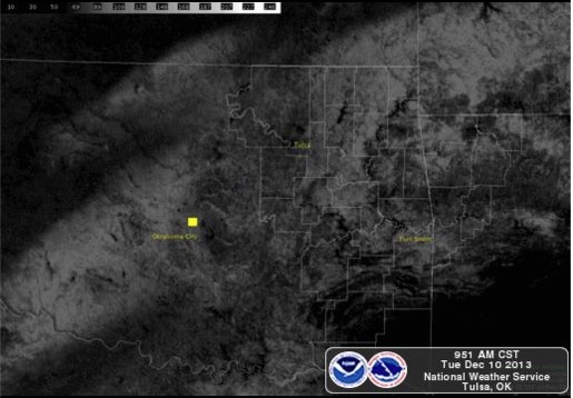
A significant winter weather event occurred between the morning hours of December 5th, and the evening hours of December 6th. With sub-freezing temperatures in place at the surface, a series of upper level disturbances passed over the area producing multiple rounds of rain, freezing rain, sleet, and snow. While the heavier snow fell across northeast Oklahoma and northwest Arkansas, damaging amounts of freezing rain occurred over southeast Oklahoma and western Arkansas. Snowfall amounts between 3 - 6 inches were common across northeast Oklahoma and northwest Arkansas, with isolated amounts over 10 inches in the higher elevations of northwest Arkansas (see snow and ice maps above left). Heavy freezing rain fell across southeast Oklahoma and western Arkansas, mainly within portions of Franklin, Le Flore, Pushmataha, and Choctaw Counties, where between a half inch to whole inch of ice accumulation brought down trees and power lines (see snow and ice maps above left). More information about the winter weather between December 5 - 6, 2013 can be found here. Light amounts of snow fell a few days later, on December 9th, when another upper level system tracked across the area. The impacts with this second storm were less severe, with snowfall amounts ranging between a trace, to 2 - 3 inches of snow. The heavier amounts fell across far northeast Oklahoma, north of Highway 412, which show up with more while snow cover on the satellite image above center. A shallow layer of very cold air was in place across much of northeast Oklahoma and portions of northwest Arkansas on December 20th, as a low pressure system approached triggering precipitation over the region. As the rain fall into the very cold air at the surface, it froze on impact, forming a glaze of ice on all elevated surfaces. The heaviest ice accumulation formed along the Highway 44 corridor, with between 0.50 - 0.75 inches of ice reported. Numerous tree limbs and some power lines were damaged. Temperatures across southeast Oklahoma remained above freezing, allowing the precipitation to fall as all rain, however, some flooding issues were reported. More information about the ice storm between December 20 - 21, 2013 can be found here.
January:
 |
 |
 |
|
January 5 Snow Storm Photo Credit: NWS Tulsa |
January 8 Ice Storm Photo Credit: NWS Tulsa |
January 12 Strong Winds Photo Credit: NWS Tulsa |
Another round of wintery weather affected the area in early January, with the first system bringing light amounts of snow to northeast Oklahoma and northwest Arkansas January 5th. Most of the precipitation occurred along and north of Highway 40, with the heavier snowfall amounts between 3 - 5 inches falling along and north of Highway 412 in far northeast Oklahoma and extreme northwest Arkansas (see image above left). A second system brought freezing rain to portions of far eastern Oklahoma and northwest Arkansas just a few days later, on January 8th. Though not as damaging as the late December ice storm, a quarter inch of ice was reported across portions of Crawford, Franklin, and Madison Counties of northwest Arkansas (see image above center). Very windy conditions develop in mid-January ahead of an approaching strong cold front. Southerly winds gusted between 40 - 50 miles per hour during the day January 12, creating high fire dangers and extreme fire spread potential. Several grass fires broke out across northeast Oklahoma, including a couple bigger fires near Hominy in Osage County, and another near Collinsville in Tulsa County. Power outages were also reported in Tulsa due to the high winds. The winds diminished that evening, and on the following day after the cold front pushed through the region.
February:
 |
 |
 |
|
February 2 Snow Storm Photo Credit: NWS Tulsa |
February 7 Snow Storm Photo Credit: NWS Tulsa |
February 10 - 11 Snow Storm Photo Credit: NWS Tulsa |
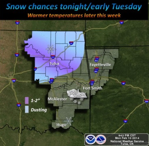
Several low pressure systems passed over the Southern Plains during the first two weeks of February while temperatures were well below normal, producing wintery weather across the area. The first system occurred early on February 2nd, when snow spread across much of northeast Oklahoma and northwest Arkansas. Further south, a mix of freezing rain, sleet, and snow fell. The heaviest snow fell from south of Okemah, through Checotah, to near Fayetteville, where 5 to 7 inches of snow was common. One to two tenths of an inch of ice accumulation occurred in far southeast Oklahoma, and a narrow band of heavy sleet just to the north of the icing area resulted in an inch and a half of sleet accumulation in the Clayton area. The resulting snow field could be seen on satellite the following day, February 3rd (see image above left). More information about the winter weather on February 2, 2014 can be found here. A few days later, on February 7th, another system brought light snow to southeast Oklahoma and portions of western Arkansas. The snow began during the late afternoon, and persisted into the evening hours. Most of the snow fell along and south of Highway-40, with the heaviest snow occurring within Pittsburg, Latimer, Pushmataha, Le Flore, Sebastian, and Franklin Counties, where between 2 and 3 inches of snow fell. A third upper level disturbance moved into the area on February 10th, bringing light snow to portions of northeast Oklahoma, mainly within Pawnee, southern Osage, Creek, Tulsa, and Wagoner Counties where between 2 and 3 inches of snow was reported. By February 13th, conditions warmed well above normal across the forecast area, with temperatures reaching into the 50s and 60s. This warming tread persisted until the last few days of February, when temperatures dropped back below normal.
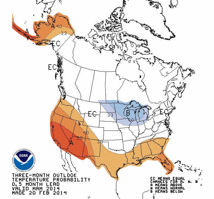
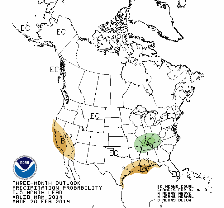
Below is a chart with the Climate Prediction Center's forecast for both temperatures and precipitation for the next three months (March - May), along with the Seasonal Drought Outlook for the spring and early summer months through June 30. For temperatures (left), all of eastern Oklahoma and northwest Arkansas fall within the "EC" or "equal chances" area. This means that there are no indications that the temperatures for the spring months will be either above or below normal, thus, normal, below normal, and above normal temperatures are all equally likely. For precipitation (center), again, all of eastern Oklahoma and northwest Arkansas show an "equal chances" rating. This means that there are no indications that the precipitation amounts will be either above or below normal, thus, normal precipitation, below normal, and above normal are all equally likely. The third image (right) depicts the Seasonal Drought Outlook for the nation through the end of June. The green area across portions of northeast and southeast Oklahoma indicate that the D-0 and D-1 drought conditions that developed by the end of February are expected to improve. The white areas across the rest of eastern Oklahoma and northwest Arkansas indicate that no D-1 drought conditions are present, and none are expected to develop.
 |
 |
 |
| Spring 2014 Temperature Outlook | Spring 2014 Precipitation Outlook | Spring 2014 Drought Outlook |
Updated: April 5, 2014


 Follow us on YouTube