
Rare Snow Storm Impacts the Deep South
January 19, 2008
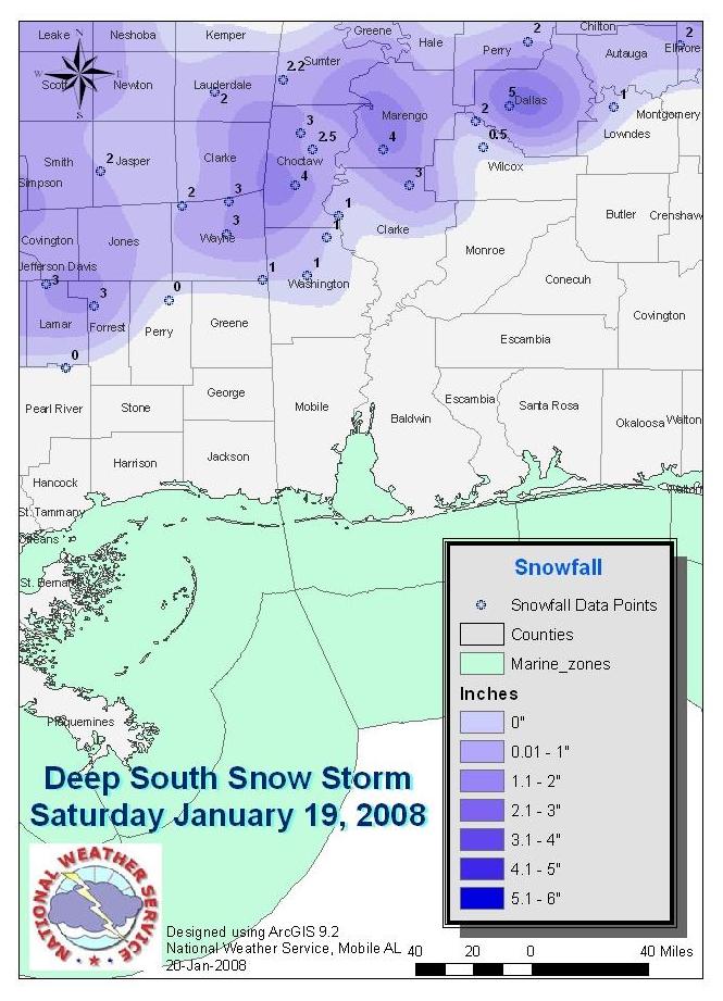
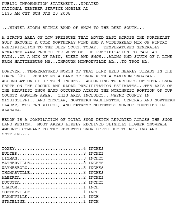
Saturday January 19, 2008 - A rare snow storm impacted the deep south from northern Louisiana east through central Mississippi and central Alabama early Saturday morning. Snow even fell over the northern counties of our county warning area. The graphic above shows bursts of heavier snows of 3-4 inches reported over northeast Wayne County in Mississippi and extended into Choctaw and northern Clarke Counties in southwest Alabama. Lighter snowfall amounts of 1-2 inches were reported over Wilcox and northern Washington Counties in southwest Alabama.
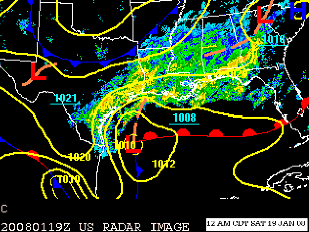
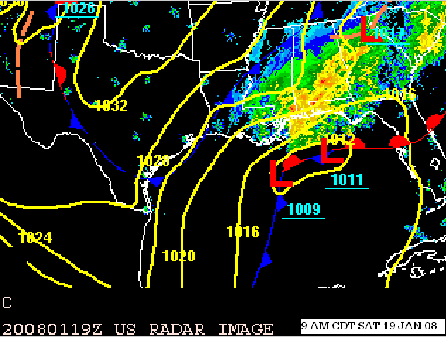
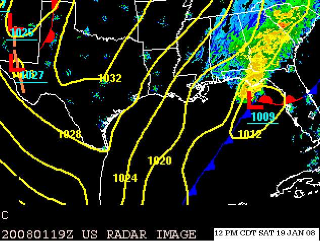
Forecasters were watching a deep upper level trough of low pressure extending from the nation's mid section into Texas. Ahead of this trough, strong upper level southwesterly winds of 100-120 knots helped to bring enhanced lift and Gulf moisture northeast into the southern states. Initially, the Deep South experienced a cool environment as the area was north of a cold front draped over the northern Gulf. Weather maps showed a wave of surface low pressure forming east of the southern Texas coastline. The Low tracked east northeast (parallel to the northern Gulf Coast).
The graphics below show the evolution of the surface pressure features overlayed with radar composites. Take note of the large moisture field spreading northeast over the southern states.
The concern for forecasters was the low level dry air and dewpoints below freezing forecast to spread into the interior of southeast Mississippi and southwest Alabama late Friday night into early Saturday morning.
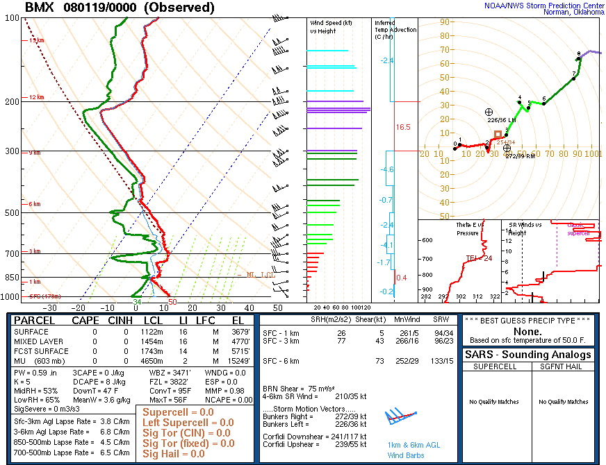
The following upper air soundings show a large spread between the temperature and dewpoint profiles, which points to dry air in the lower levels of the atmosphere. Also, note the subfreezing dewpoint temperatures. The stage was set for precipitation falling through this layer to enhance evaporation, which would result in a rapid cool down of the temperature profile by Saturday morning.
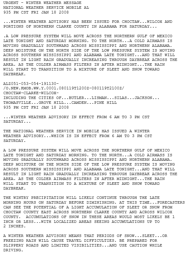
After diagnosing the large scale flow, ascent, moisture and forecast low and deep layer temperature profiles, along with coordination with adjacent offices, forecasters issued a Winter Weather Advisory on Friday evening January 18, 2008. Winter Weather Advisories are issued when a mixture of light freezing drizzle or light freezing rain, light sleet and or light snow is expected within 12-24 hours.
The complexity of Deep South winter weather events have several unknowns/questions that present problems for forecasters. Some of these in this case were:
* The degree of cooling which would take place due to evaporation
* Timing of the reinforcing surge of colder air
* How much moisture would be present for the cold air to work with
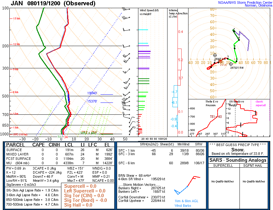
As the surface low pressure system moved eastward Saturday morning, an arctic air mass surged southeast. With the help of evaporative cooling in combination with the reinforcement of arctic air into the region, the temperature profile did indeed fall to below freezing. Look what happened to the soundings:
With the temperature/dewpoint profile much closer, indicating high moisture content air and the deep column of subfreezing temperatures in the low levels, these soundings represent an atmosphere supportive of snow.
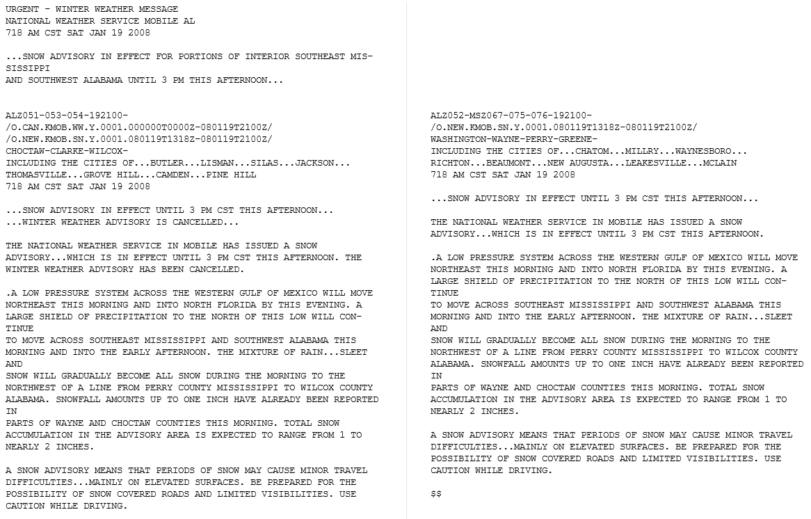
With snowfall being observed and looking to meet advisory criteria: (A light accumulation of snow of 1/2 inch to less than 2 inches of snow is expected within 24 hours) A Snow Advisory was issued after sunrise Saturday morning for portions of the interior of southwest Alabama.
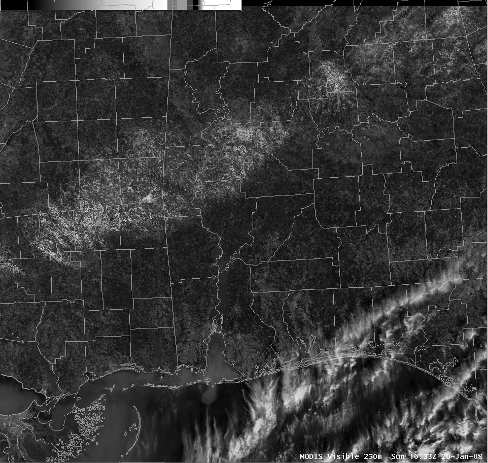
Since snowfall is highly reflective, the high resolution visible imagery taken late Saturday morning shows the snowfall footprint exceptionally well.
Acknowledgements: Page initially created by Joe Maniscalco (Forecaster) and Ray Ball (ITO). Page updated by Morgan Barry (Forecaster).
LAST UPDATED: October 2016


 Follow us on YouTube