

 |
During the morning hours of December 20th in 2012, an EF-1 tornado developed and moved over the Mobile metro area. This tornado was in association with a thunderstorm that moved northeast off the Gulf of Mexico into coastal Mississippi and then further northeast into central Mobile County.
The tornado path in the image to the left shows the tornado formed around 449am CST near Davidson High School in Mobile. The tornado lifted near Telegraph Road in Prichard, AL. The tornado path was approximately 7 miles in length and 50 to 75 yards in width.
Another tornado on December 25th of 2012 (Christmas Day) would later go on to take a very similar path. Details on the December 25, 2012 Mobile Metro Area Tornado can be found on this webpage.
Storm survey results from the December 20, 2012 Tornado.
A powerful December storm system centered over Missouri was producing snow on its northwest side over the Upper Midwest while simultaneously producing severe thunderstorms across portions of the Deep South (as depicted in the weather map below).
 Along the central Gulf Coast, the atmosphere began to destabilize late on December 19th. This destabilization trend continued into the early morning hours on December 20th as unseasonably mild conditions prevailed and minimum temperatures only fell into the 60s across inland locations with temperatures in the low 70s closer to the coast.
Mobile Metro Area EF-1 Tornado
Around 205am CST, radar began to detect a very weak rain shower located off the southeast coast of Louisiana as seen in the first radar image below. This rain shower was moving to the northeast and slowly strengthening.
By 321am CST, significant rotation developed throughout a great depth of the updraft of the thunderstorm and a parent mesocyclone formed in this thunderstorm. This progression can be viewed in the second radar image below. The mesocyclone became the parent circulation of the EF-1 tornado that moved across the Mobile metro area.


 The first Tornado Warning was issued at 411am CST for the southwest corner of Mobile County. A subsequent follow-up Tornado Warning issued at 442am CST and included the Mobile metro area. A spatial view of these Tornado Warnings can be seen in the image to the right.
Based on a near immediate ground survey, it was determined that this EF-1 tornado formed on Michael Boulevard near the YMCA and the Davidson High School baseball field in Mobile around 449am CST.
The graphics below show a radar time series of the evolution of the tornado parent circulation from beginning to end across the Mobile metro area. On the left side of each image is the radar base reflectivity and on the right side of each image is the radar storm relative velocity.
The first two images below show radar data approximately two minutes prior to and after tornado formation. Radar Imagery Tip: the white dot depicts the initial tornado formation location. The remaining three images show the remainder of the storm’s evolution between 456am and 505am CST on December 20, 2012.
The highest winds estimated along the path were from 86-109 mph, which corresponds to an EF-1 tornado. Many homes along the path had significant roof damage.
 447am |
 451am |
 456am 456am |
 501am 501am |
 505am 505am |
It is interesting to note that on October 25 in 2010, a weak tornado initially formed just west of the intersection of Michael Boulevard and Azalea Road and moved east while creating sporadic damage to the Festival Center. Path details on the October 25 tornado can be found on this webpage. Visit the Tornado Museum for more in-depth information on this storm.
Avalon Point, FL Tornado
 In addition to the Mobile metro area tornado, another tornado formed over Pensacola Bay and very near Avalon Point, FL. The image to the right shows a picture of the tornado over water and the vantage point where the picture was taken at 1009am CST. The tornado picture was taken just before it dissipated over the water (it never moved onto land).
It should be emphasized, for preparedness and educational purposes, this is a tornado over water – not a typical summertime waterspout which is characterized by much weaker wind speeds and a different formation process.
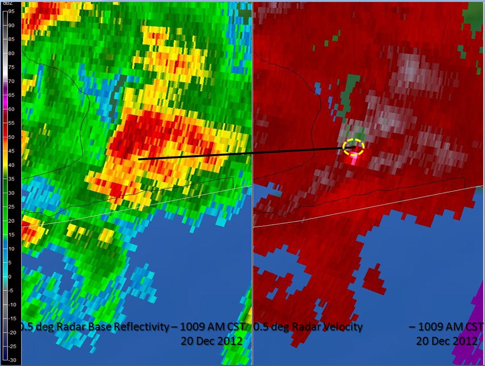
The image below shows the tornado’s parent circulation on radar at the same time (1009am CST). A Tornado Warning was in effect for this thunderstorm at the time the picture was taken.
It should be emphasized that most parent circulations (what meteorologists call 'mesocyclones') that developed during this event were not very tall in height and were less than 25,000 ft above ground level for the most part. The overwhelming majority of the mesocyclones were not even associated with lightning despite the production of tornadoes.
 |
 |
 |
 |
 |
 |
 |
 |
 |
 |
 |
 |
 |
 |
 |
 |
 |
 |
 |
 |
Acknowledgements: Page initially created by Jeffrey Medlin (Meteorologist In Charge) and Ray Ball (Information Technology Officer). Page updated by Morgan Barry (forecaster).
LAST UPDATED: October 2017


 Follow us on YouTube