
Choctaw County Tornado
December 16, 2019
----- IMPORTANT 2023 UPDATE -----
Significant updates were made to several tornado tracks and wind swaths impacting the NWS Mobile/Pensacola area in the 2018 to 2023 timeframe thanks to the introduction of high-resolution Sentinel, Worldview, and Planet satellite imagery. One or multiple tornado tracks/wind swaths listed on this event webpage were updated in 2023.
An updated graphic and details surrounding these significant updates can be found further down on this webpage in the section for that specific tornado track or wind swath. More information on this Local Tornado Reanalysis Project and a list of all updates can be found on our webpage at weather.gov/mob/TornadoReanalysis or the National Damage Viewer.
Here is a list of the significant updates:
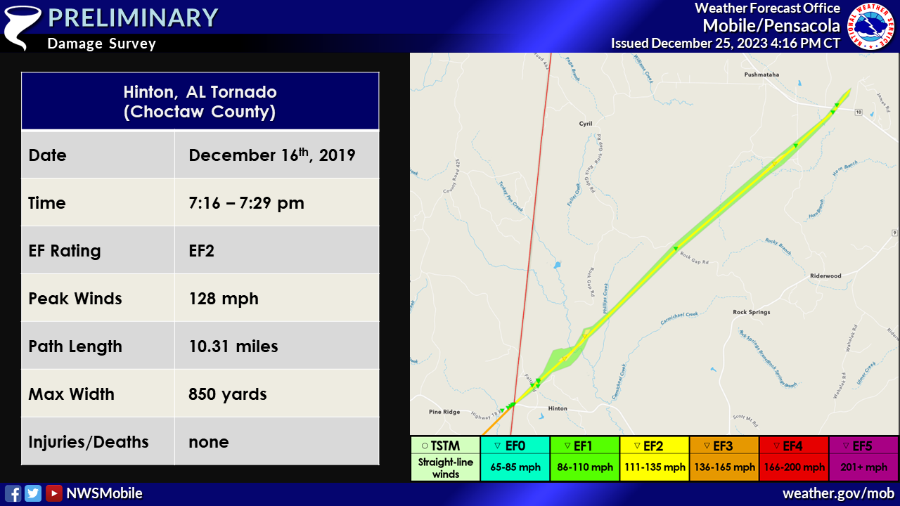
1. December 16, 2019 - Updated Tornado - Choctaw County, AL: Upgraded this tornado from an EF1 tornado to a high-end EF2 tornado and lengthened the track based on extensive deforestation (widespread leveling of the forest in a few spots) noted on Planet and Worldview satellite imagery. The EF2 points occurred primarily in densely forested areas, largely inaccessible to the survey team. The tornado length in the NWS Mobile CWA is 10.3 miles, width is 850 yards, and maximum intensity is 128 mph. Notes: This long-track tornado began near Laurel, MS (NWS Jackson CWA) and was rated higher due to the damage along the track west of our area, thus the entire tornado is rated EF3.
CHOCTAW COUNTY, AL TORNADO

...UPDATED NWS DAMAGE SURVEY INFORMATION FOR 12/16/2019 CHOCTAW
COUNTY TORNADO EVENT...
.CHOCTAW COUNTY TORNADO...
RATING: EF-1
ESTIMATED PEAK WIND: 110 MPH
PATH LENGTH /STATUTE/: 9.9 MILES
PATH WIDTH /MAXIMUM/: 300 YARDS
FATALITIES: 0
INJURIES: 0
START DATE: DEC 16 2019
START TIME: 716 PM CST
START LOCATION: CR 20 AT CLARKE COUNTY LINE
START LAT/LON: 32.0876/-88.4491
END DATE: DEC 16 2019
END TIME: 729 PM CST
END LOCATION: 2.5 MILES WNW OF LISMAN AL
END LAT/LON: 32.1848/-88.3246
SURVEY SUMMARY: TORNADO MOVED INTO CHOCTAW COUNTY AL FROM CLARKE
COUNTY MS ALONG CR 20. SEVERAL SOFTWOOD TREES WERE SNAPPED AND HARDWOODS
UPROOTED ALONG CR 20. AS THE TORNADO MOVED NORTHEAST, TREE DAMAGE
CONTINUED ALONG HINTON RD AND FAITH RD IN THE HINTON COMMUNITY. MINOR
ROOF DAMAGE OCCURRED TO A HOME ALONG HINTON ROAD AND A SINGLE WIDE MODULAR
HOME WAS FLIPPED ON ITS SIDE AND HEAVILY DAMAGED. THE TRACK CONTINUED
NORTHEAST ACROSS ROCK GAP RD AND EVENTUALLY ACROSS MT. NEBO RD WHERE
NUMEROUS HARD AND SOFTWOODS WERE UPROOTED OR SNAPPED. A ROOF OF A TWO
STORY HOME WAS PARTIALLY REMOVED ALONG HIGHWAY 10 AND SEVERAL LARGE
HARDWOOD TREES WERE UPROOTED. THE TORNADO CROSSED HIGHWAY 10 WHERE IT
LIFTED JUST WEST OF RUFFINTOWN RD. THE DAMAGE ALONG THE CHOCTAW COUNTY
PORTION OF THE TRACK WAS CONSISTENT WITH A HIGH-END EF-1.
THIS TORNADO IS A CONTINUATION OF A TRACK THAT BEGAN IN JONES COUNTY
MS AND PRODUCED EF-3 DAMAGE IN LAUREL. BASED ON INFORMATION FROM NWS
JACKSON, THE TORNADO TRACKED A TOTAL OF 51 MILES FROM JONES COUNTY
NORTHEAST INTO CLARKE COUNTY MS. THE TORNADO CONTINUED AN ADDITIONAL
10 MILES IN CHOCTAW COUNTY AL BEFORE LIFTING. PLEASE REFER TO THE
PUBLIC INFORMATION STATEMENT FROM NWS JACKSON FOR DETAILS OF THE
MISSISSIPPI PORTION OF THE TRACK.
EF SCALE: THE ENHANCED FUJITA SCALE CLASSIFIES
TORNADOES INTO THE FOLLOWING CATEGORIES.
EF0...WEAK......65 TO 85 MPH
EF1...WEAK......86 TO 110 MPH
EF2...STRONG....111 TO 135 MPH
EF3...STRONG....136 TO 165 MPH
EF4...VIOLENT...166 TO 200 MPH
EF5...VIOLENT...>200 MPH
NOTE:
THE INFORMATION IN THIS STATEMENT IS PRELIMINARY AND SUBJECT TO
CHANGE PENDING FINAL REVIEW OF THE EVENT AND PUBLICATION IN
NWS STORM DATA.
Acknowledgements: Page created by Jason Beaman (Warning Coordination Meteorologist). Page updated by Caitlin Baldwin (Forecaster).
LAST UPDATED: March 2024


 Follow us on YouTube