
Late March Tornado Outbreak
March 30-31, 2022
Summary of all Local Storm Reports (LSRs) on March 30-31, as well as all the LSRs across the region for this event.
Storm survey teams preliminarily concluded that there were 18 tornadoes in our forecast area. The tally of tornadoes in our forecast area stands at:
MISSISSIPPI: 6 tornadoes (1 EF-2 in Greene County, 4 EF-1s in Wayne County, and EF-0 in Perry County)
ALABAMA: 9 tornadoes (EF-1 in Choctaw County, EF-1 in Wilcox County, EF-1 in Clarke County, 1 EF-1 and 3 EF-0s in Mobile County, and 2 EF-0s in Baldwin County)
FLORIDA: 3 tornadoes (2 EF-1s in Santa Rosa County and EF-0 in Escambia County)
The data provided on this page are considered preliminary as we continue to analyze all available data. We will add more information to this page and social media as it becomes available. We thank you in advance for your patience.
A special thank you to our county and state EMAs in addition to the NWS Office in New Orleans, LA and the NWS Office in Jackson, MS for their assistance with several of these tornado surveys.
----- IMPORTANT 2023 UPDATE -----
Significant updates were made to several tornado tracks and wind swaths impacting the NWS Mobile/Pensacola area in the 2018 to 2023 timeframe thanks to the introduction of high-resolution Sentinel, Worldview, and Planet satellite imagery. One or multiple tornado tracks/wind swaths listed on this event webpage were updated in 2023.
An updated graphic and details surrounding these significant updates can be found further down on this webpage in the section for that specific tornado track or wind swath. More information on this Local Tornado Reanalysis Project and a list of all updates can be found on our webpage at weather.gov/mob/TornadoReanalysis or the National Damage Viewer.
Here is a list of the significant updates:
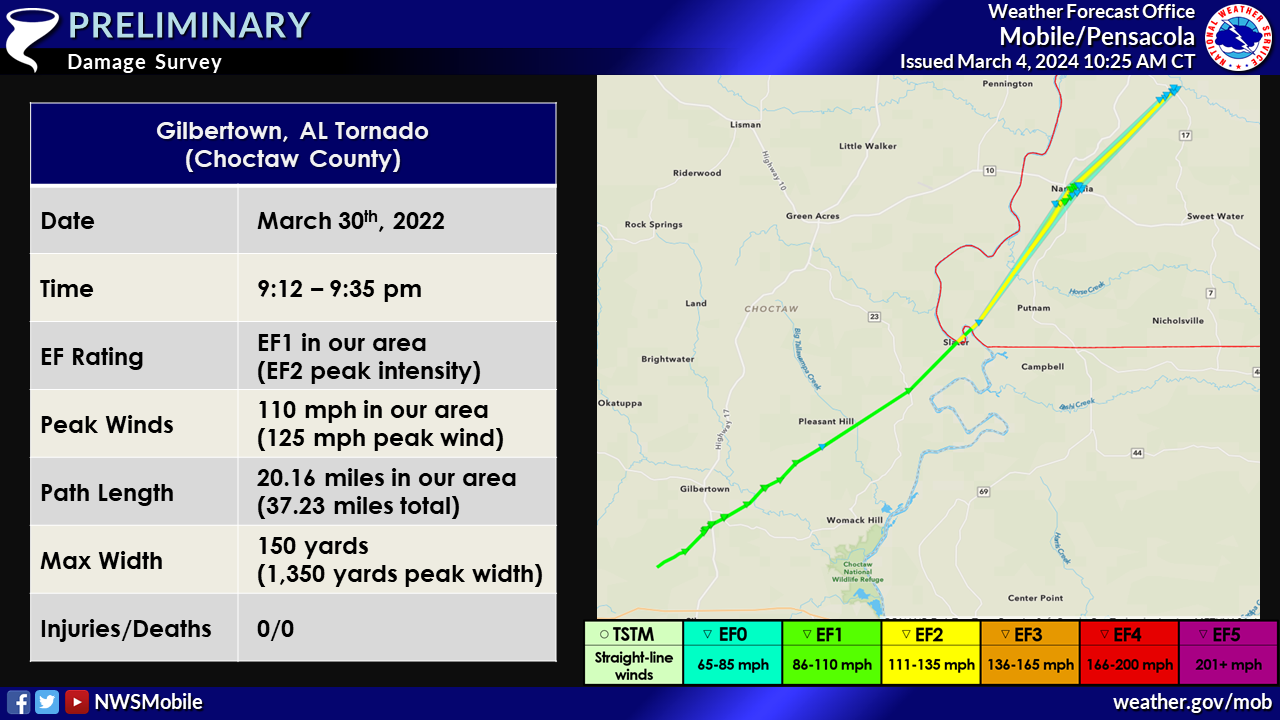
1. March 30, 2022 - Updated Tornado - Choctaw County, AL: The length of the tornado that moved across the southeastern portion of Choctaw County, AL was extended based on notable tree damage and defoliation of vegetation noted on Sentinel satellite imagery. The starting point was moved to the southwest of the Panther/Conners Rd area. The new path length is 20.157 miles in our CWA - the tornado continued into NWS Birmingham’s CWA (Marengo County, AL). Storm Data has been updated to reflect these changes.
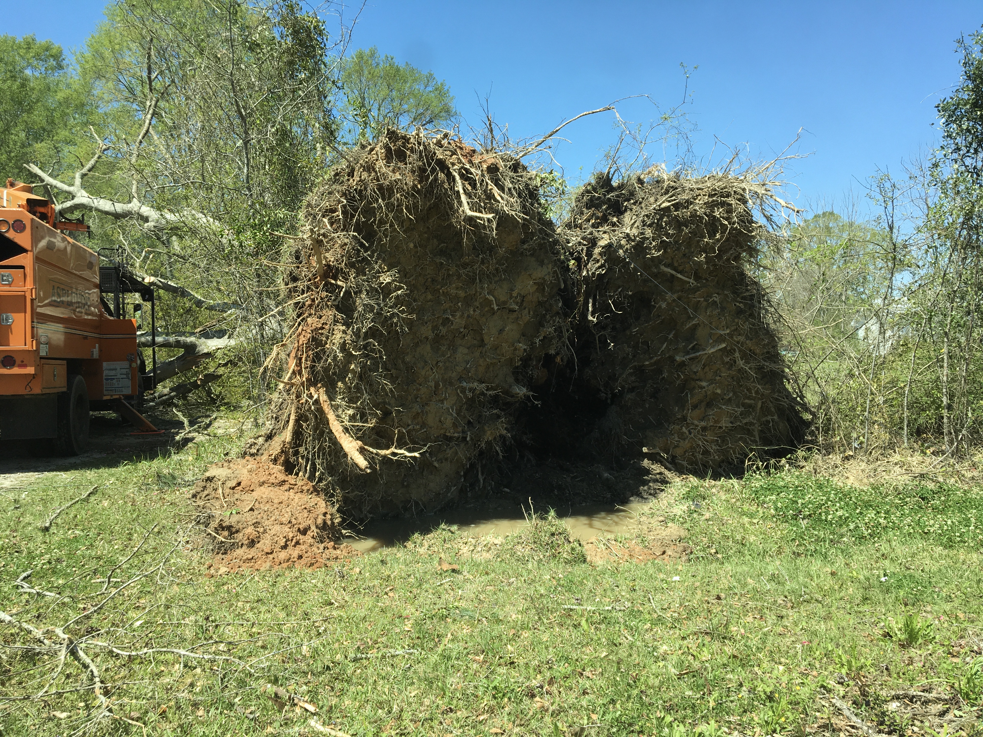
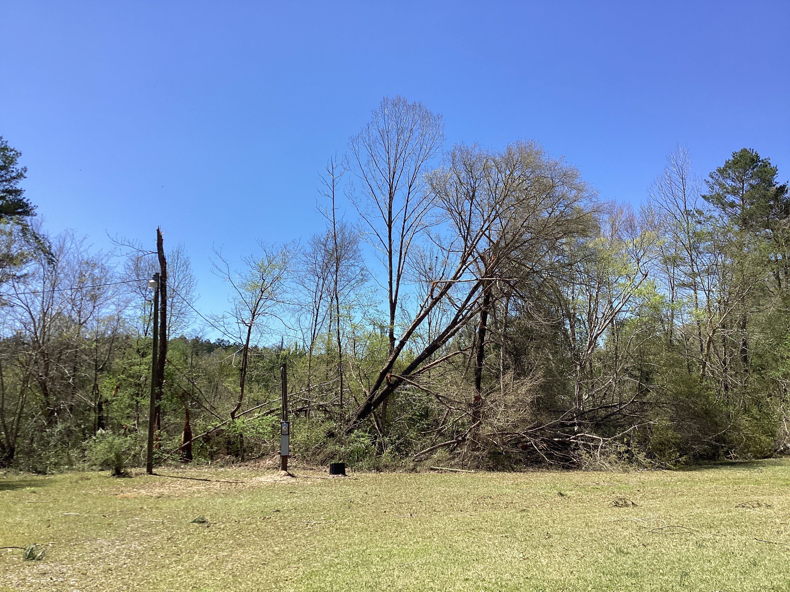
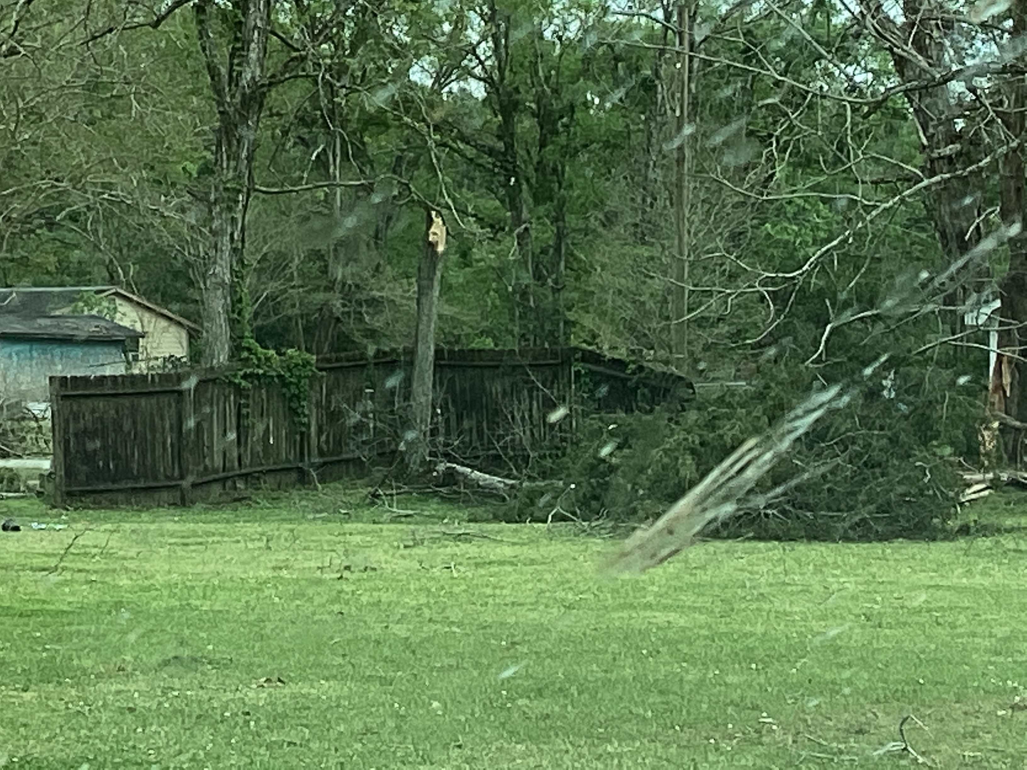
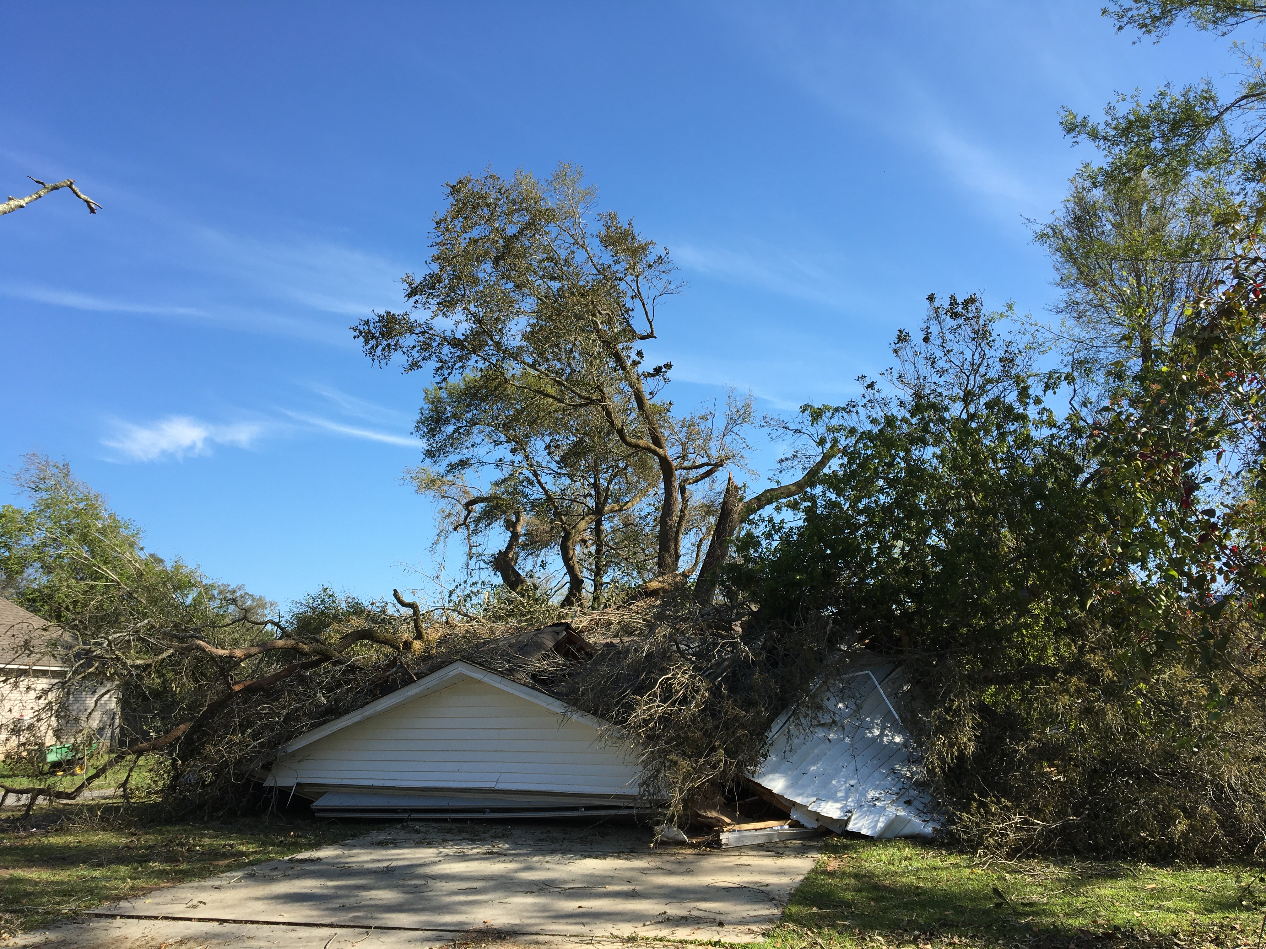
McLain Tornado (Greene County, MS)
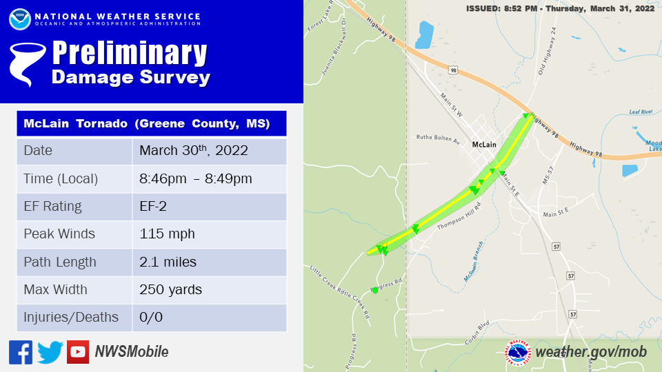
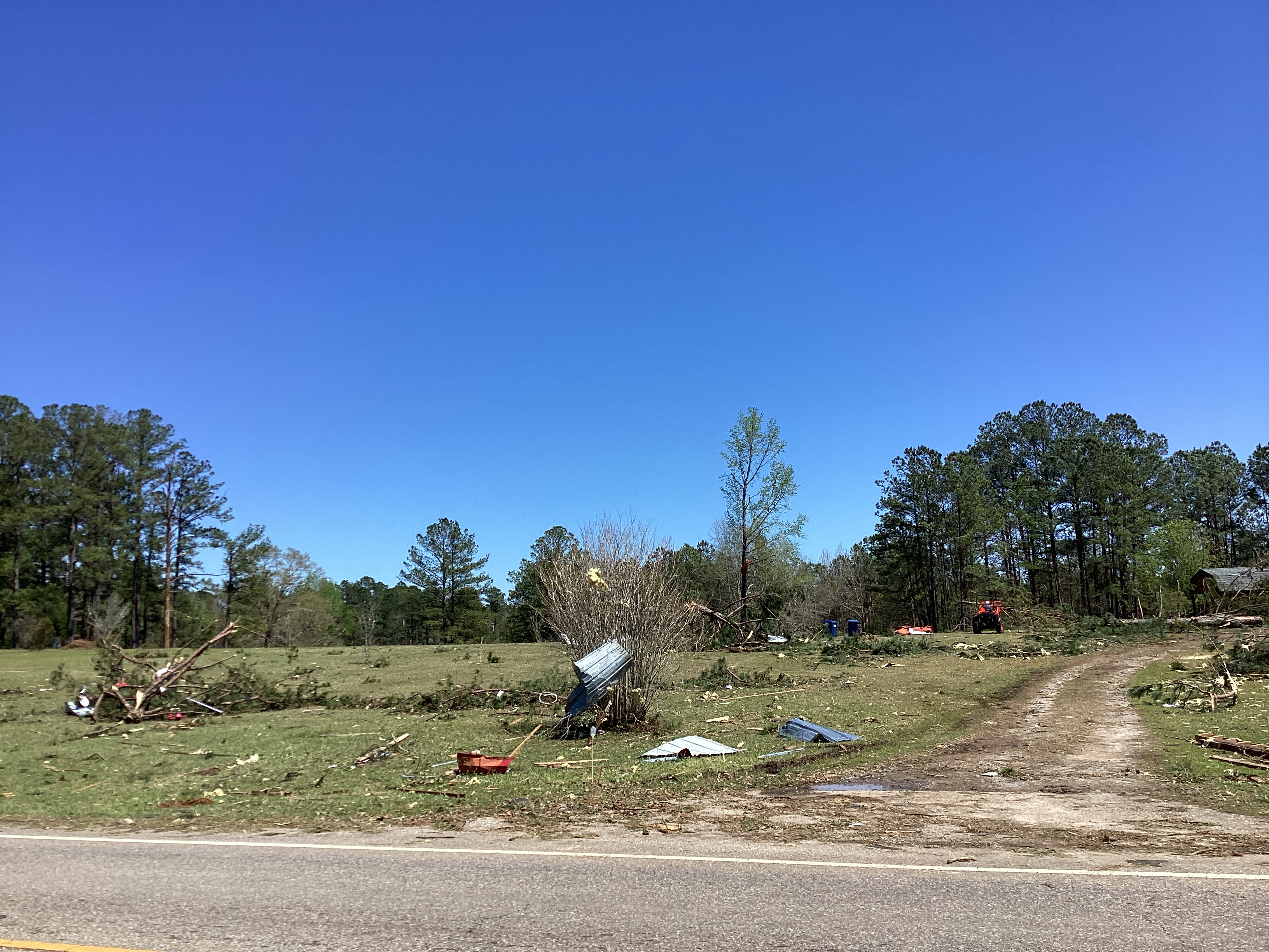
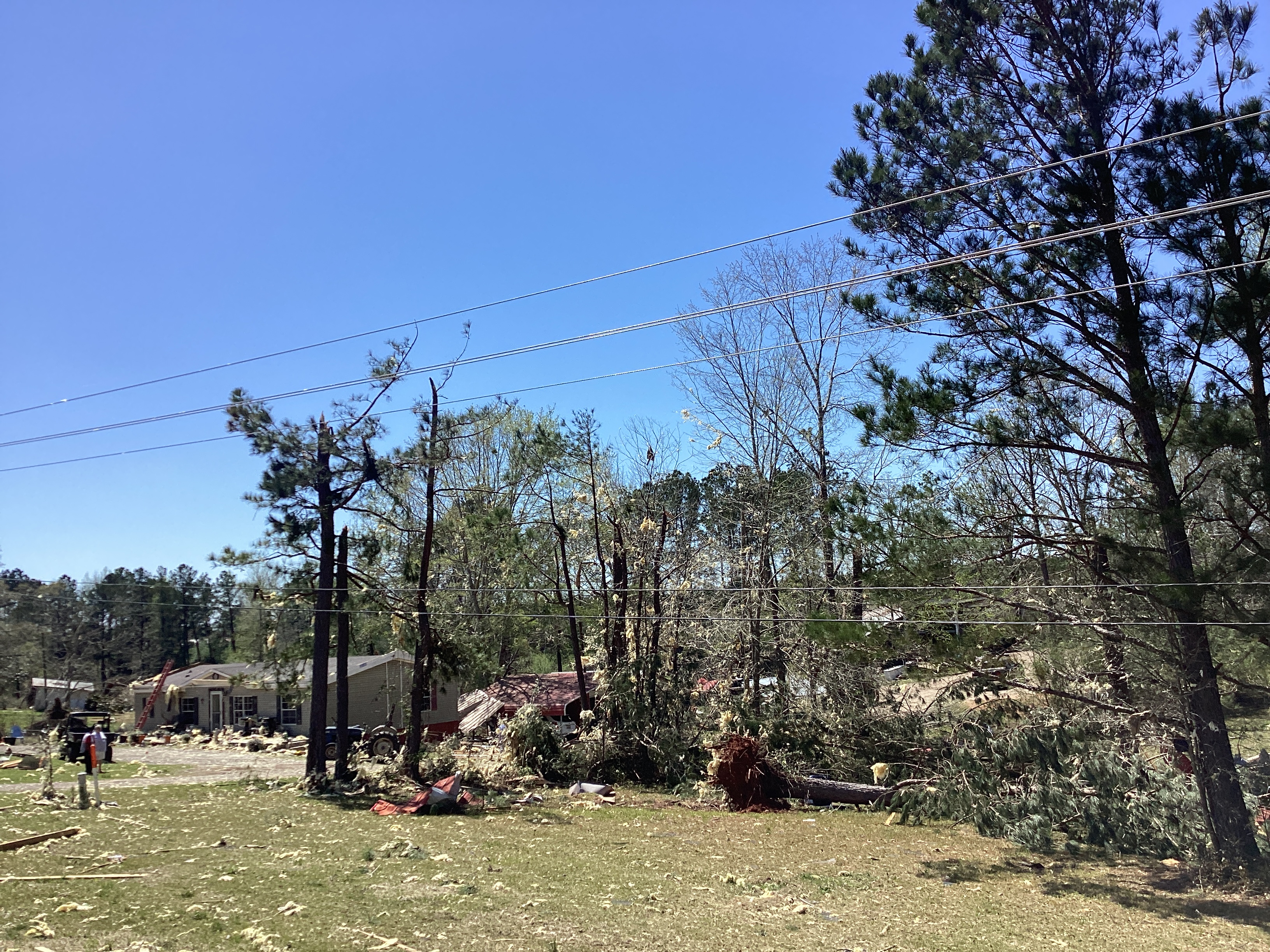
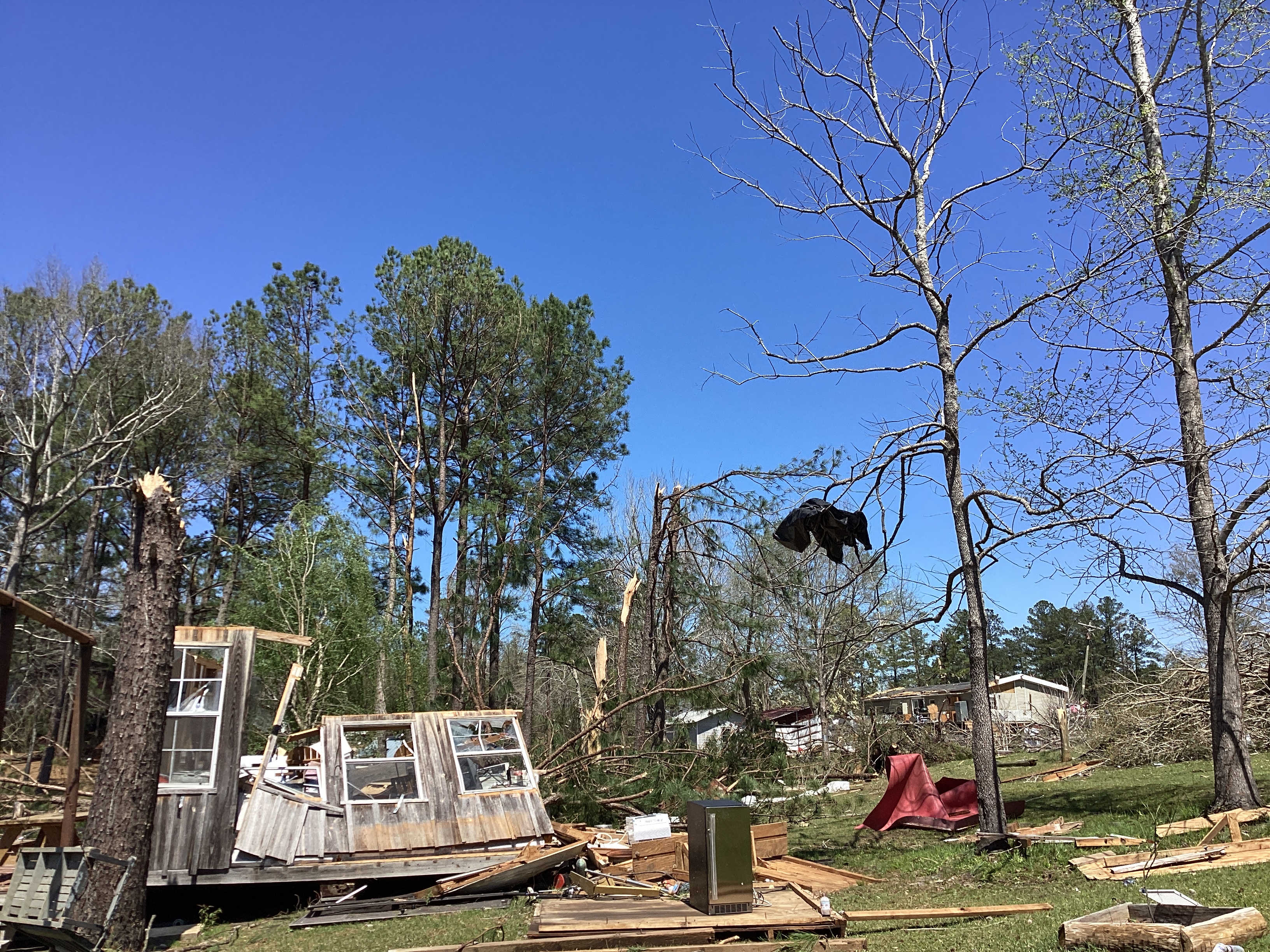
Public Information Statement
National Weather Service Mobile AL
938 PM CDT Thu Mar 31 2022

...NWS Damage Survey for 03/30/2022 Greene County, MS and
Mobile County, AL Tornado Event...

.McLain Tornado...

Rating:                 EF2
Estimated Peak Wind:    115 mph
Path Length /statute/:  2.0865 miles
Path Width /maximum/:   250.0 yards
Fatalities:             0
Injuries:               0

Start Date:             03/30/2022
Start Time:             08:46 PM CDT
Start Location:         1 NNE Progress / Perry County / MS
Start Lat/Lon:          31.0954 / -88.8476

End Date:               03/30/2022
End Time:               08:49 PM CDT
End Location:           1 NE Mclain / Greene County / MS
End Lat/Lon:            31.1127 / -88.8196

Survey Summary:
The tornado began in Perry County, MS near Punch Harvison Drive
and quickly intensified to peak strength near Leo Harvison Dr
where a large stand of softwood pines were cleanly snapped just
above the base. Adjacent to this, the metal roof of a home was
largely removed. However, an open carport on the west end of the
house provided a failure point; therefore, leaned toward the lower
end of the intensity estimates likely marking the right side of
the vortex. Several other hardwoods and softwoods were snapped or
uprooted near the home and several animal enclosures were damaged
or destroyed behind the house. The tornado weakened slightly as it
continued northeast across Dogwood Lane where a couple of snapped
softwoods and uprooted hardwoods were noted. An attached carport
to another home along Dogwood Lane also collapsed. The tornado
then began to widen to 250 yards as it approached Poplar Ave and
Thompson Hill Road in Mclain, MS (Greene County). Numerous
hardwoods and some softwoods were uprooted along Poplar Ave and
several homes had part of their tin roofs removed, likely due to
porch overhangs. A manufactured home was rolled on its side, with
two large pine trees that had fallen on top of it. The tornado
then crossed Main Street in Mclain causing roof damage to a
church, destroying a brick church sign, and uprooting and snapping
several hardwood and softwood trees. The tornado then continued
northeast towards Highway 98 where an abandoned single story
apartment building was partially destroyed with complete roof
removal. While damage was significant to the structure, poor
construction was noted and only minor tree damage to the
surrounding forest prevented a higher rating at this location. The
tornado lifted as it crossed Highway 98 with no damage noted
north of the highway.
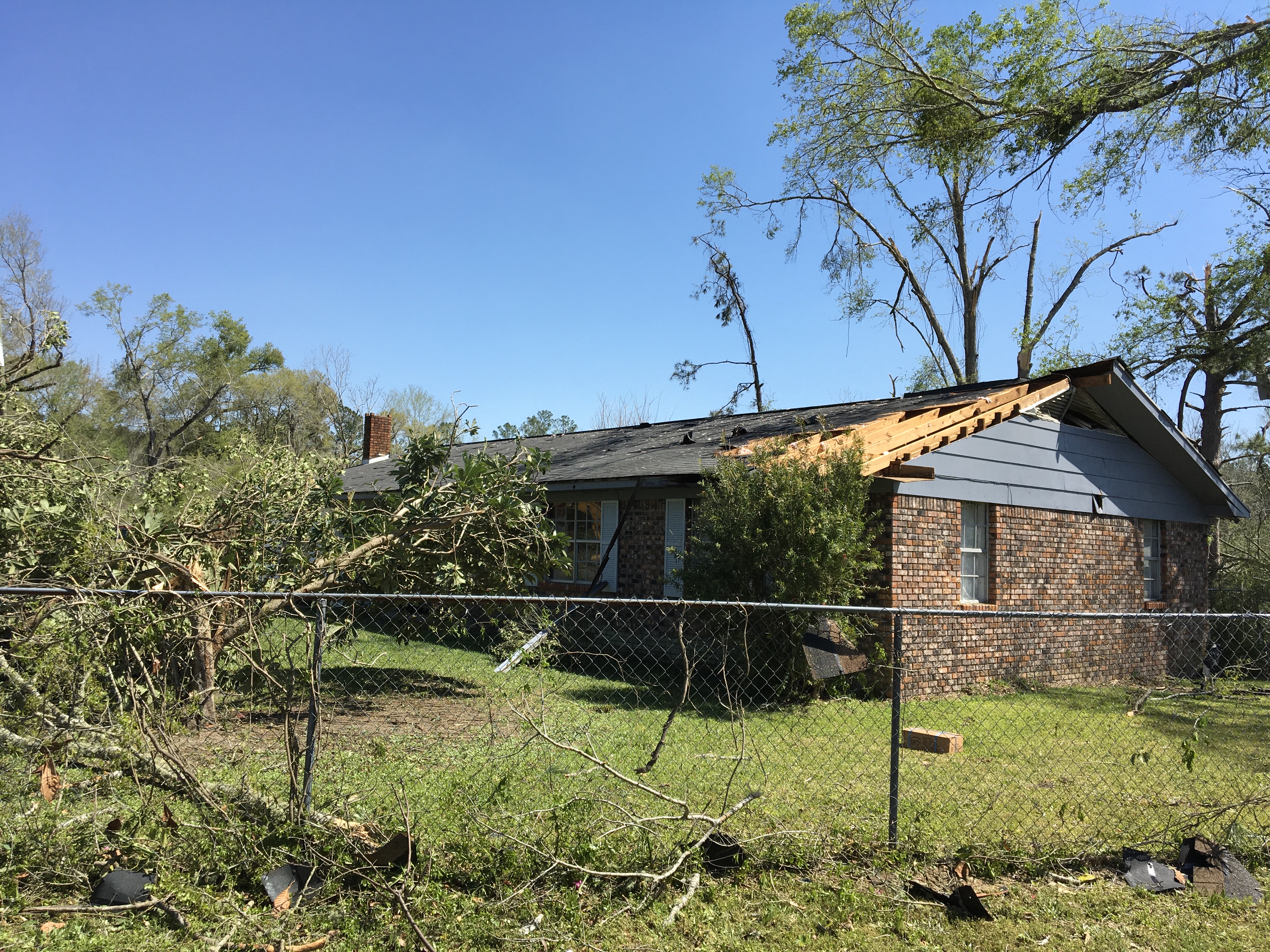
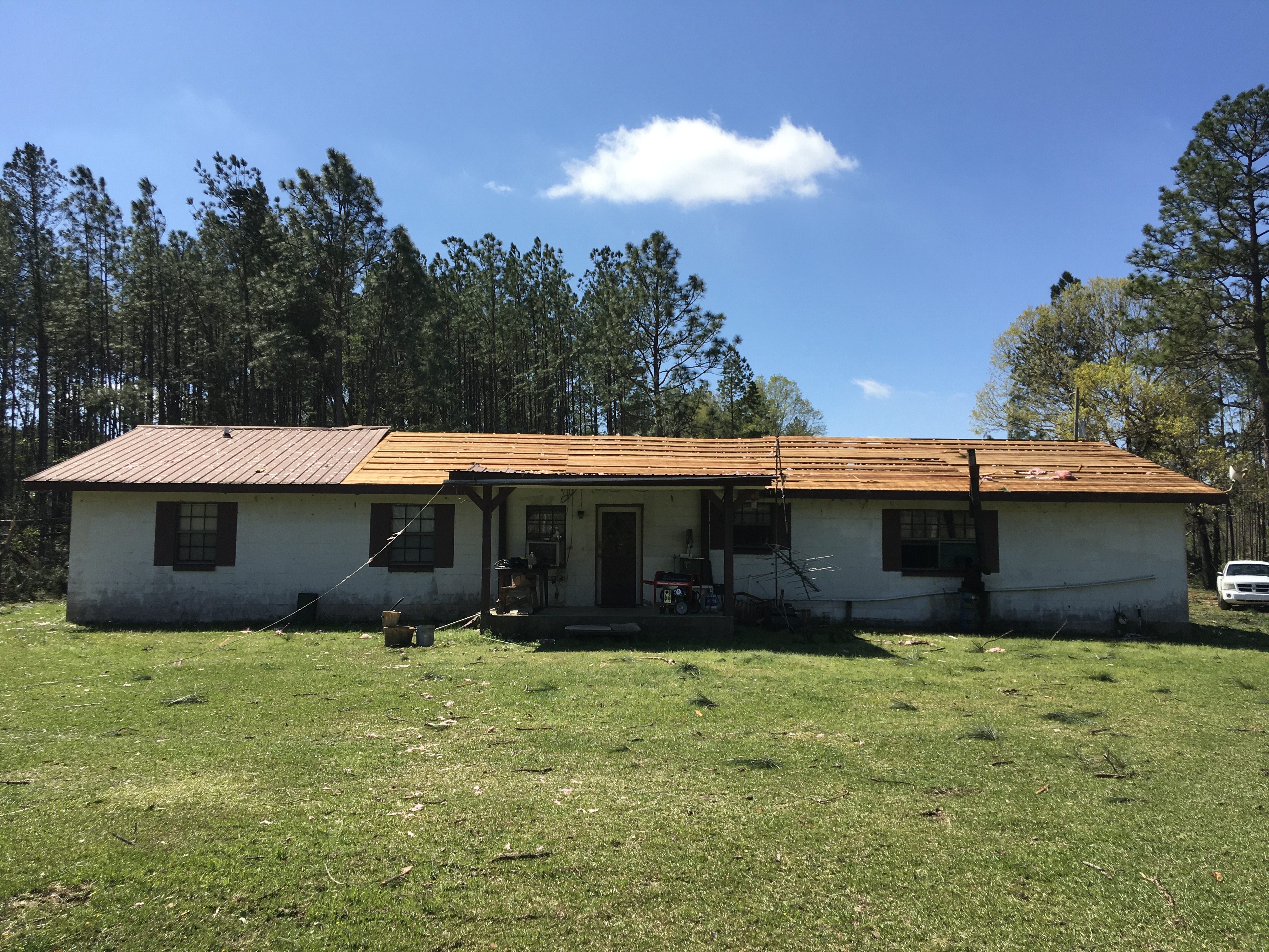
The photos below were taken during the tornado survey in the McLain community and show the extent of the damage along the path of the EF-2 tornado.

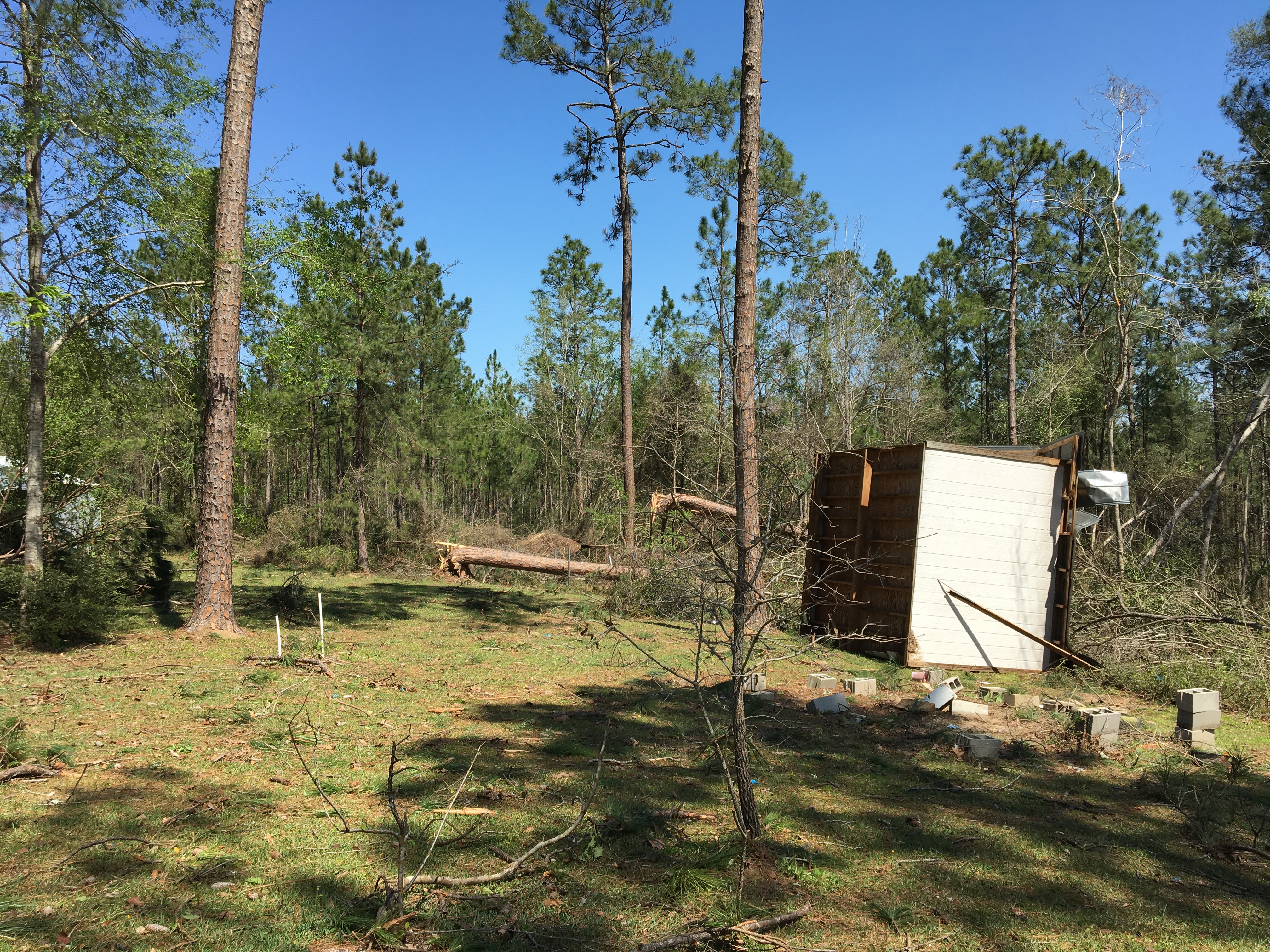

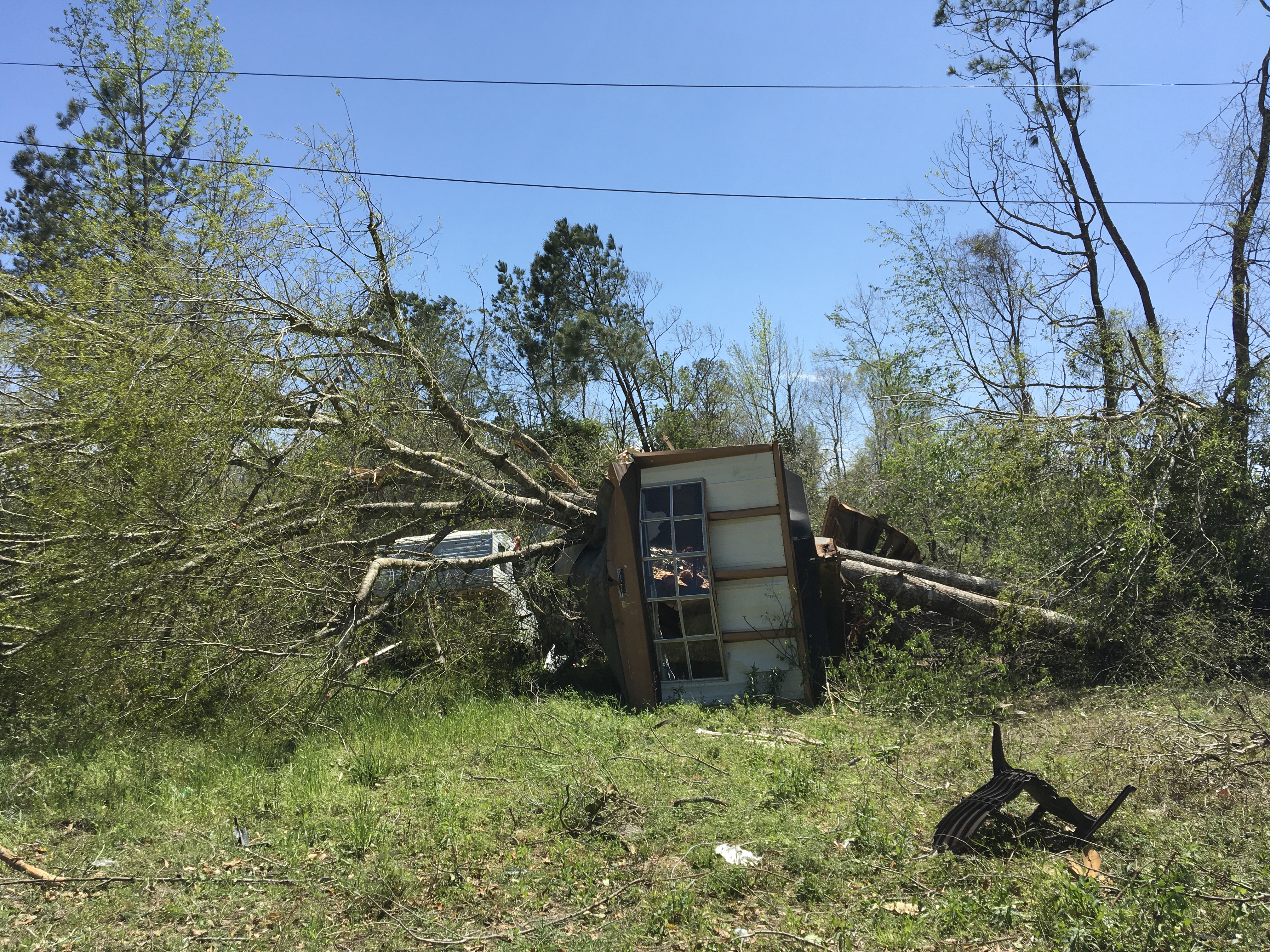
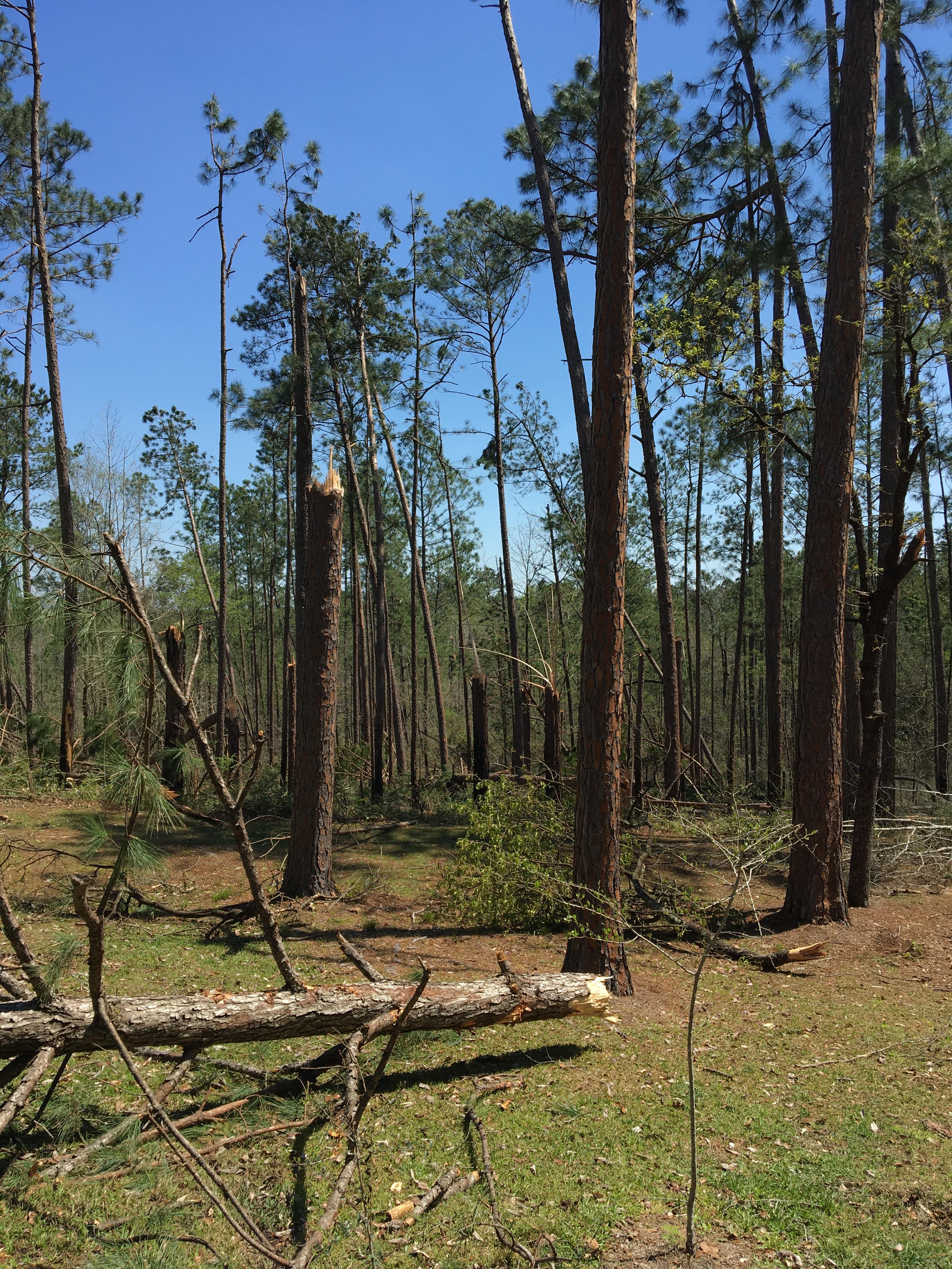
Southern Perry County, MS Tornado
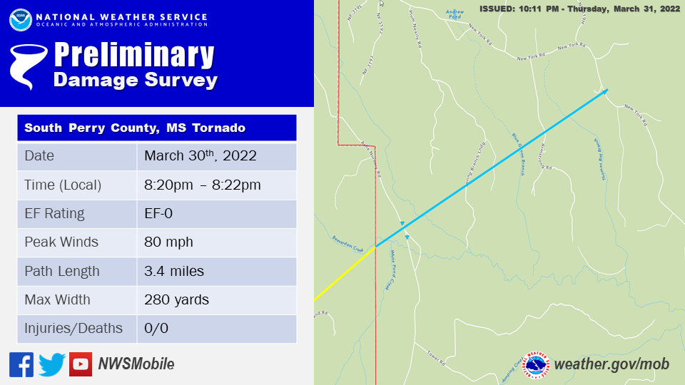
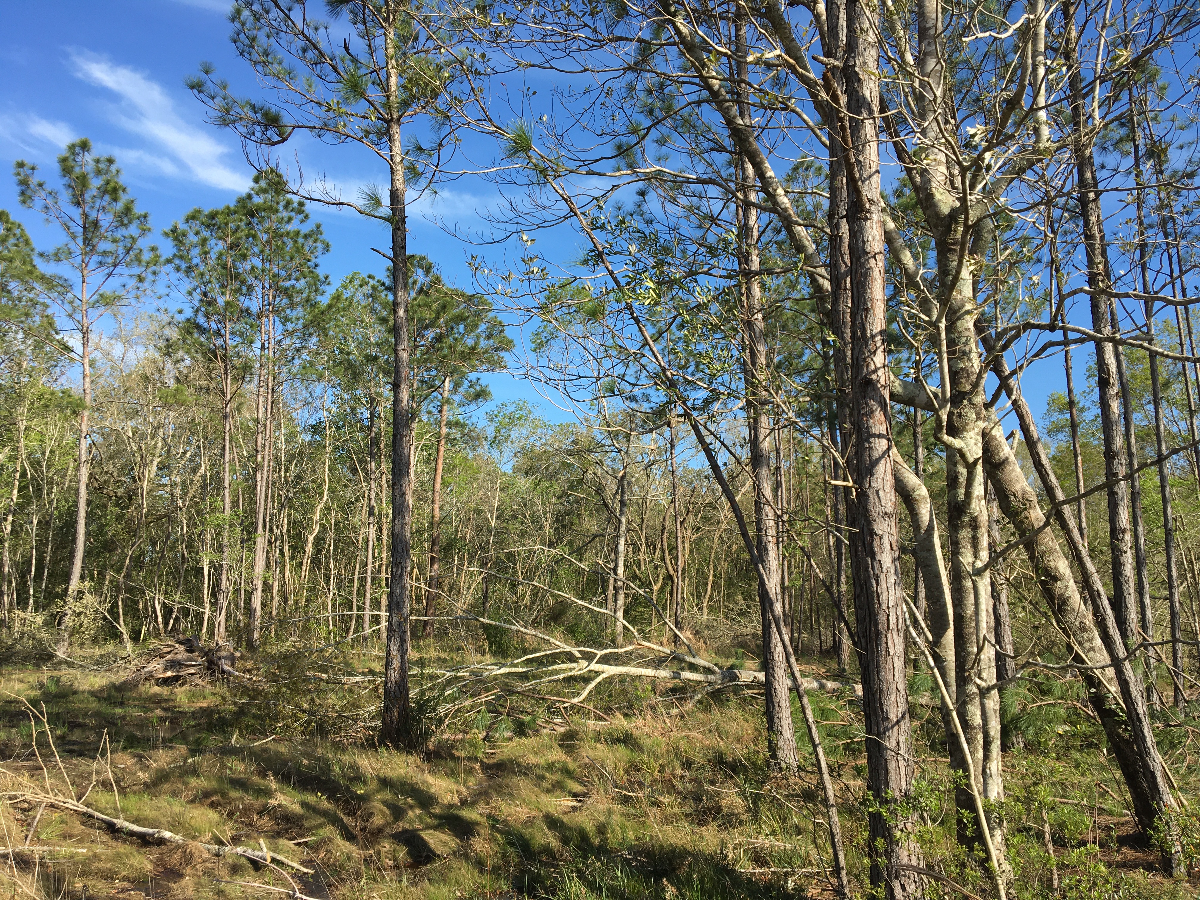
Public Information Statement
National Weather Service Mobile AL
1123 PM CDT Thu Mar 31 2022

...NWS Damage Survey for 03/30/2022 Perry County Tornado Event...

..Southwest Perry County Tornado...

Rating:                 EF0
Estimated Peak Wind:    80 mph
Path Length /statute/:  3.4 miles
Path Width /maximum/:   280.0 yards
Fatalities:             0
Injuries:               0

Start Date:             03/30/2022
Start Time:             08:20 PM CDT
Start Location:         6 NNE Bond / Forrest County / MS
Start Lat/Lon:          30.9849 / -89.1382

End Date:               03/30/2022
End Time:               08:22 PM CDT
End Location:           3 WSW Janice / Perry County / MS
End Lat/Lon:            31.0091 / -89.0884

Survey Summary:
An EF-0 tornado continued to move northeast across the Forrest
and Perry County line toward the community of Janice. Sporadic
tree damage was noted along this path with a few trees uprooted
along Ashe Nursery Rd near the county line. The tornado lifted a
little more than 3 miles away from the county line near New York
Rd to the west-southwest of Janice. This EF-0 tornado in southwest
Perry County is a continuation of the EF-2 tornado that tracked
across southeast Forrest County. For more information on the rest
of the tornado track in Forrest county, see the PNS from NWS
Jackson, MS.
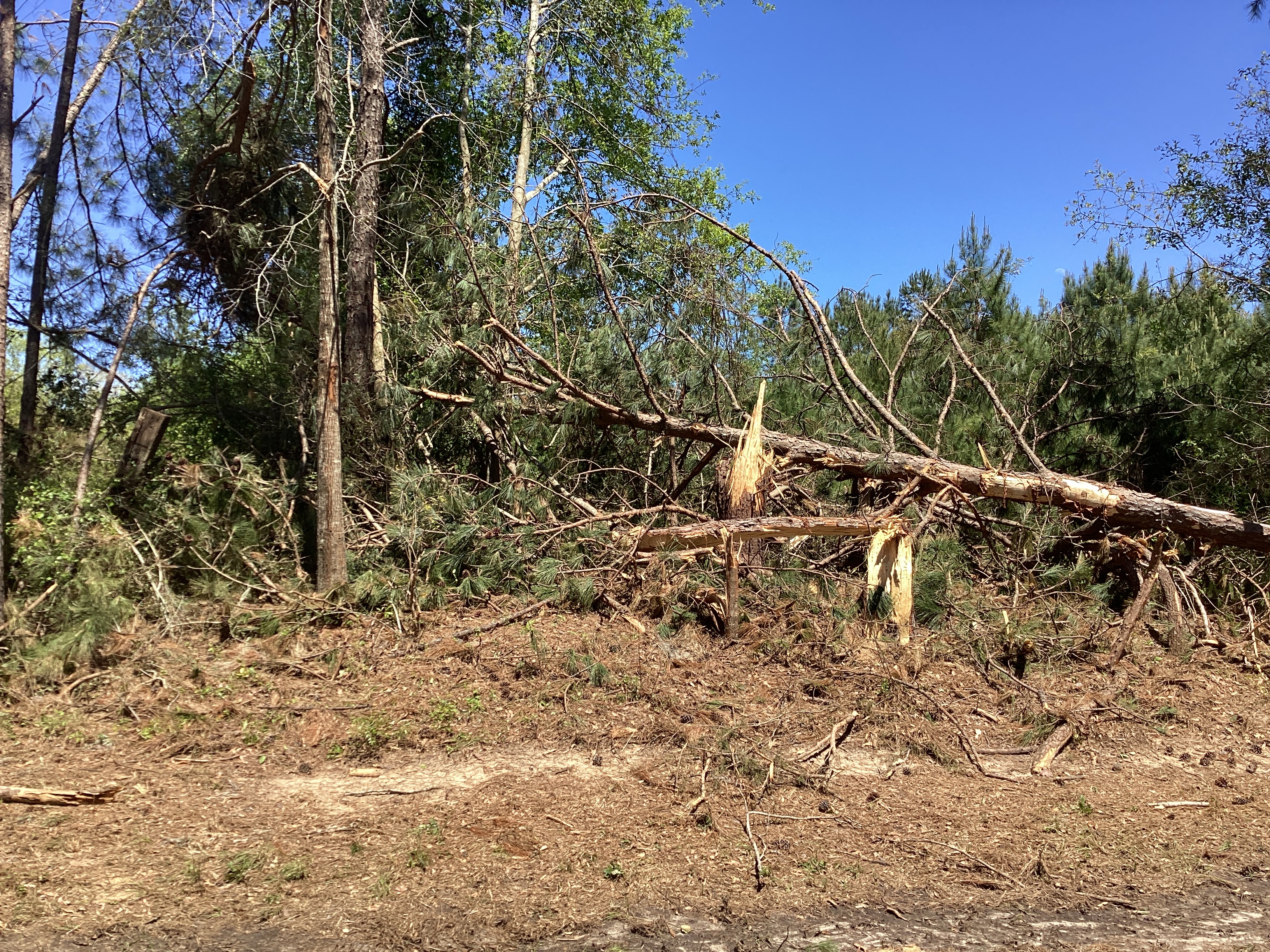
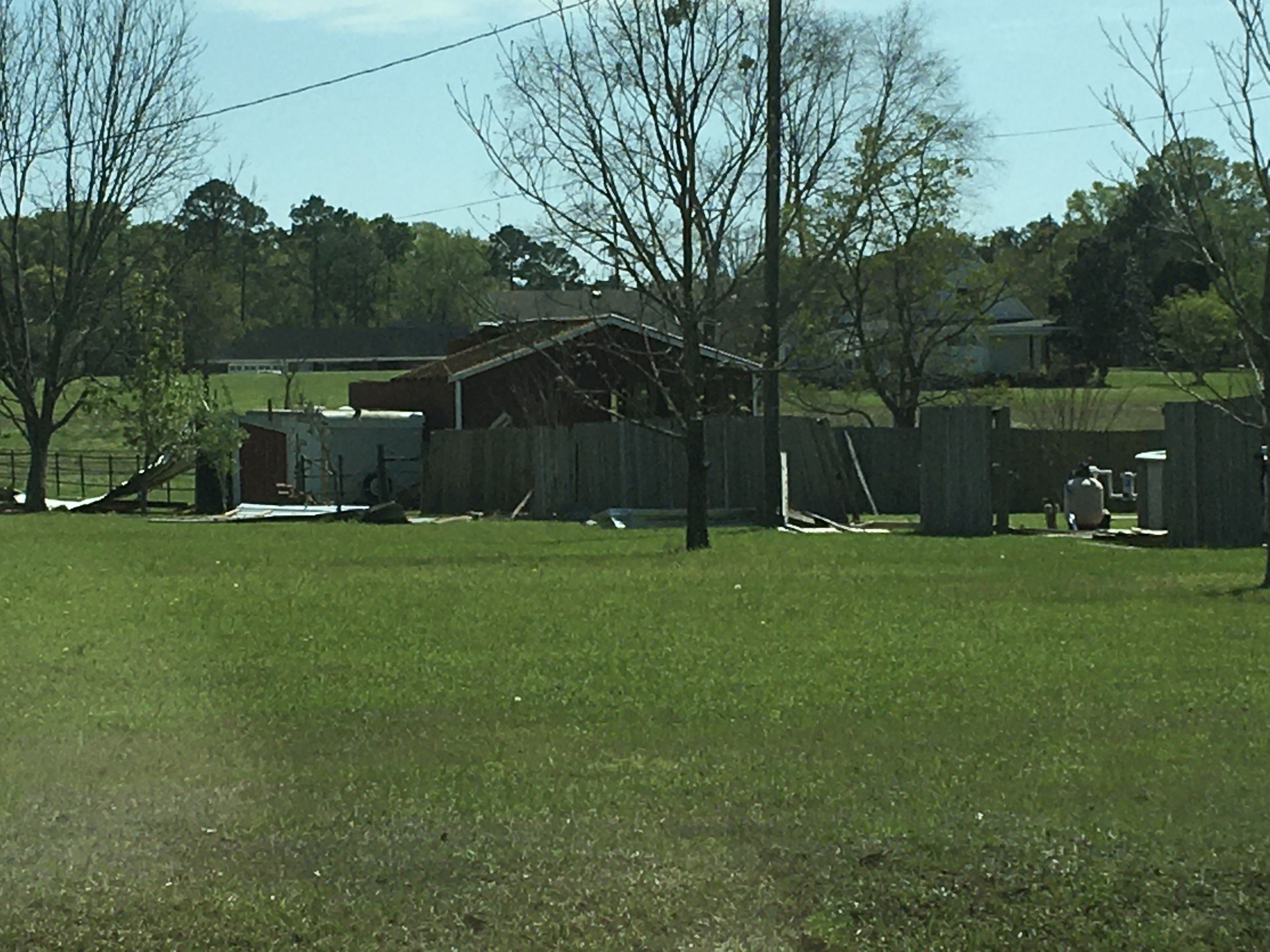
Little Rock Road Tornado (Wayne County, MS)
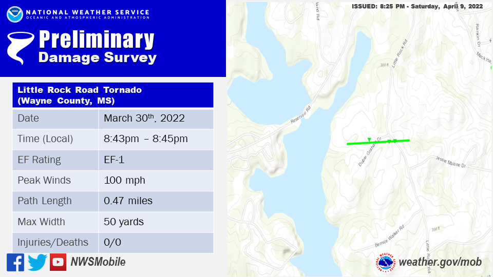
..Wayne County Little Rock Road Tornado...

Rating:                 EF1
Estimated Peak Wind:    100 mph
Path Length /statute/:  0.47 miles
Path Width /maximum/:   50.0 yards
Fatalities:             0
Injuries:               0

Start Date:             03/30/2022
Start Time:             08:43 PM CDT
Start Location:         4 SW Woodwards / Wayne County / MS
Start Lat/Lon:          31.6558 / -88.71

End Date:               03/30/2022
End Time:               08:45 PM CDT
End Location:           3 SW Woodwards / Wayne County / MS
End Lat/Lon:            31.6561 / -88.702

Survey Summary:
The first of several tornadoes began 4 miles southwest of Woodwards
at 8:43 PM CDT on March 30th, 2022. The tornado began off of
Dubie Graham Drive where a house suffered moderate roof damage
with shingles torn off and partial uplift of the roof deck.
Several softwood trees were uprooted/snapped as it continued east
across Little Rock Road. This was the only area of notable
convergent damage and due to limited road access the start and end
points have been estimated.
The photo below was taken during the tornado survey and shows the extent of the damage along the path of the tornado.
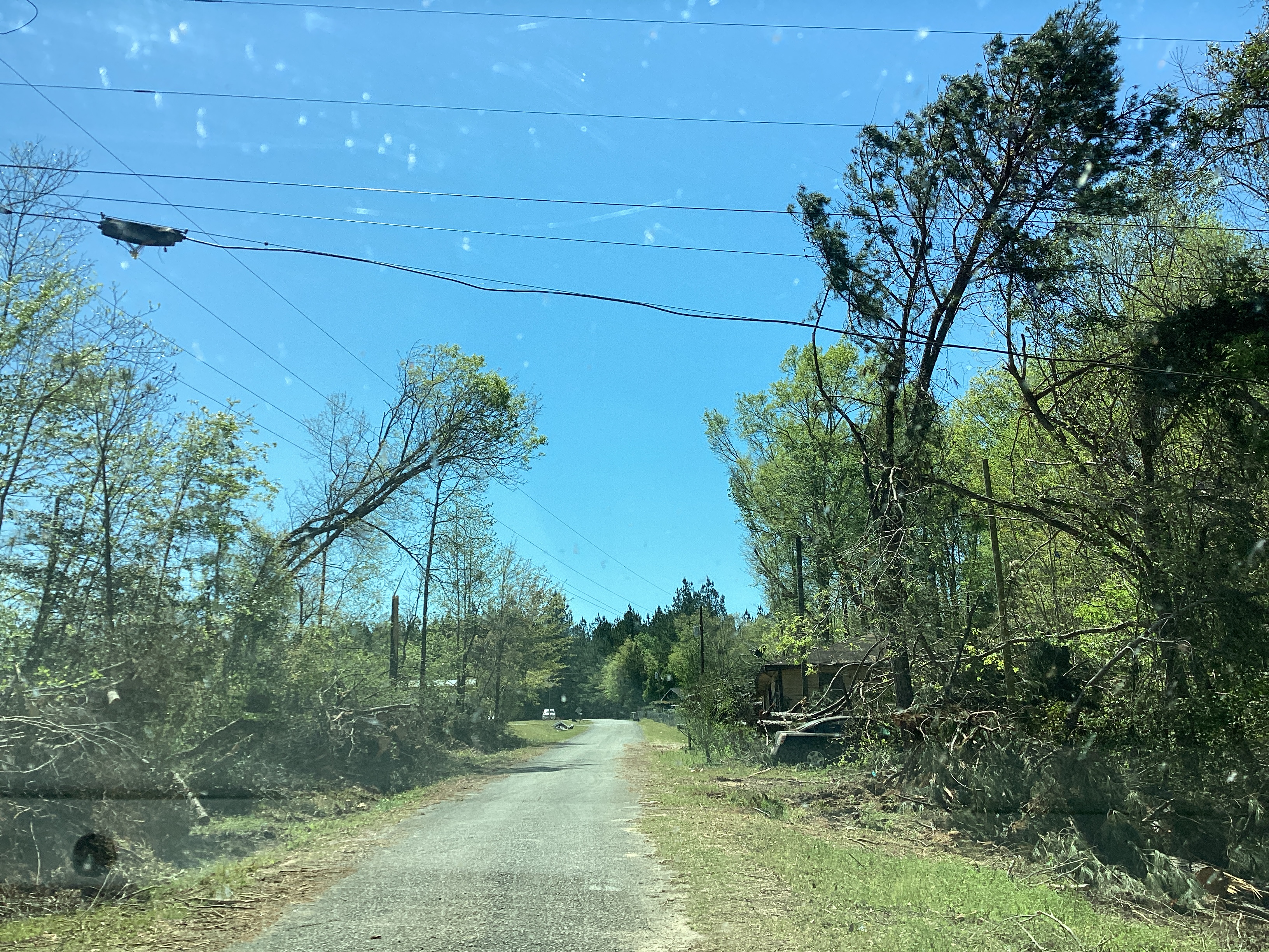
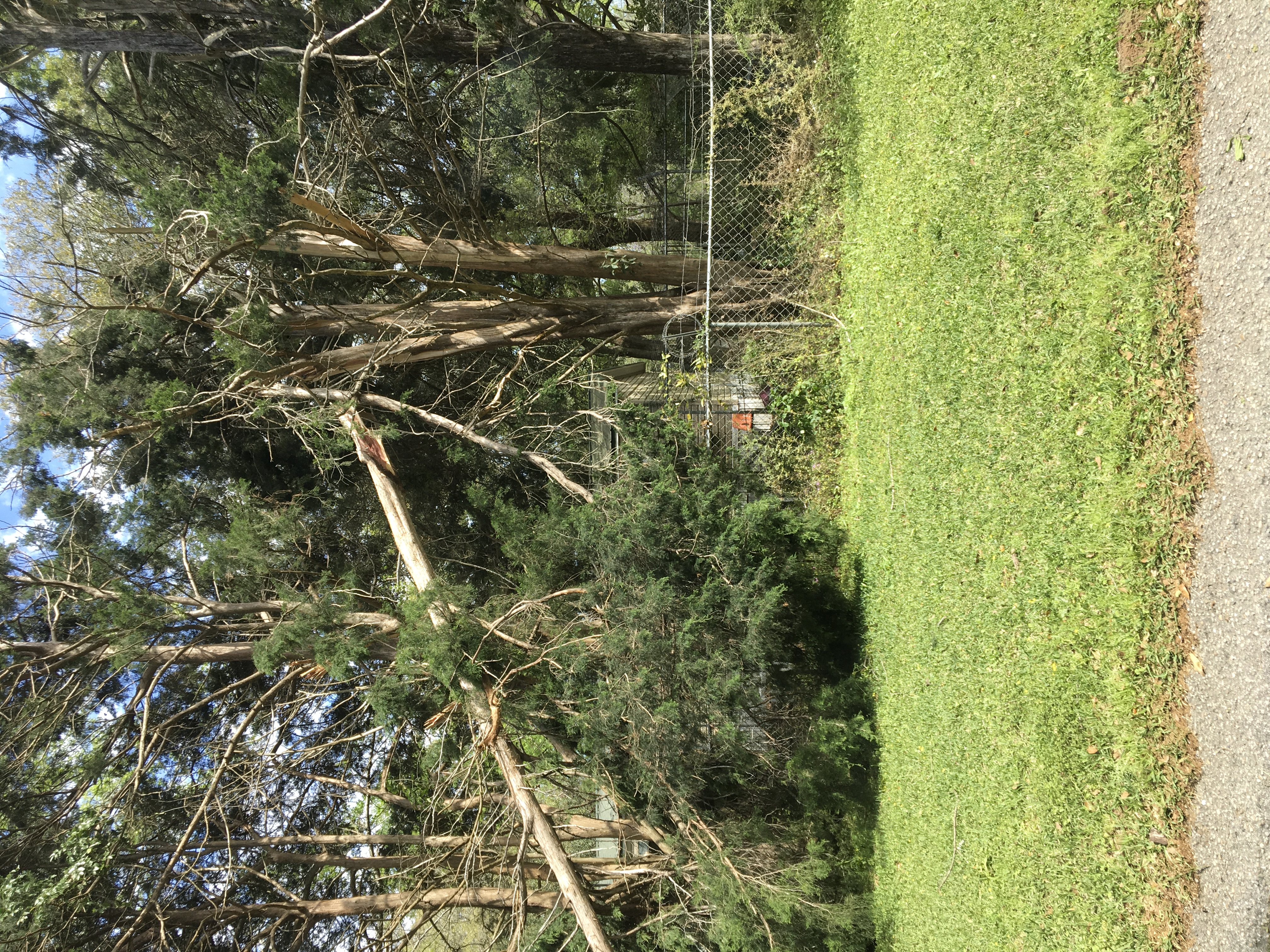
Mack Hayes Drive Tornado (Wayne County, MS)
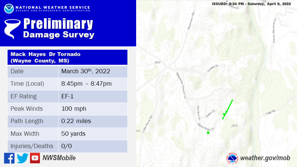
..Wayne County Mack Hayes Drive Tornado...

Rating:                 EF1
Estimated Peak Wind:    100 mph
Path Length /statute/:  0.22 miles
Path Width /maximum/:   50.0 yards
Fatalities:             0
Injuries:               0

Start Date:             03/30/2022
Start Time:             08:45 PM CDT
Start Location:         2 SSW Woodwards / Wayne County / MS
Start Lat/Lon:          31.6636 / -88.6886

End Date:               03/30/2022
End Time:               08:47 PM CDT
End Location:           2 SSW Woodwards / Wayne County / MS
End Lat/Lon:            31.6662 / -88.6866

Survey Summary:
A very brief EF1 tornado began shortly after the first to the
northeast towards Mack Hayes Drive at 8:45 PM CDT March 30th,
2022. This tornado uprooted and snapped multiple softwood trees
with one or two landing on an adjacent home. A mobile home
sustained some damage to its roof nearby. The damage on Mack Hayes
Drive was the only observable damage given nearby forest and
limited road access.
The photo below was taken during the tornado survey and shows the extent of the damage along the path of the tornado.
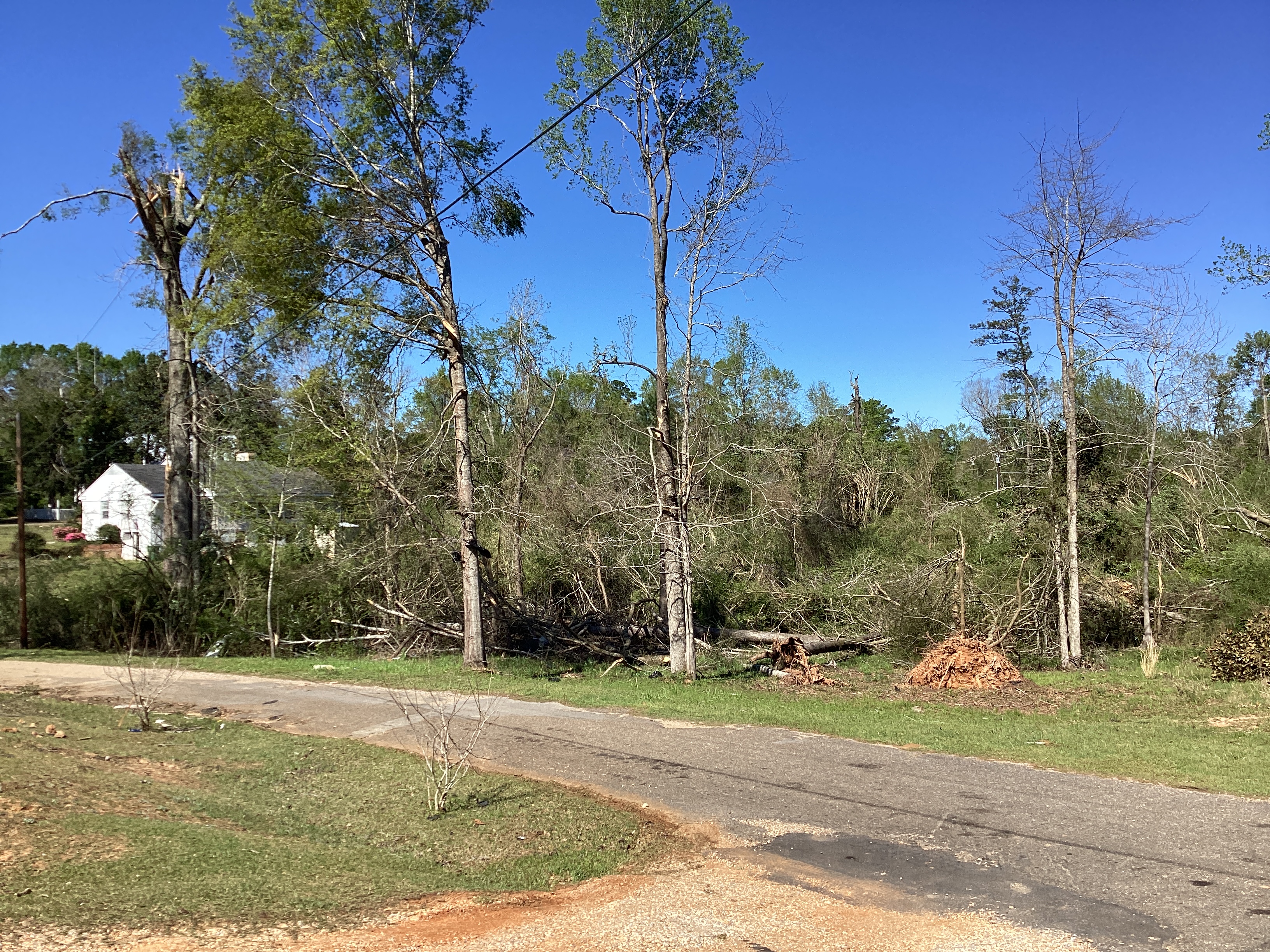
NW Waynesboro Tornado (Wayne County, MS)

..Wayne County Northwestern Waynesboro Tornado...

Rating:                 EF1
Estimated Peak Wind:    100 mph
Path Length /statute/:  1.89 miles
Path Width /maximum/:   30.0 yards
Fatalities:             0
Injuries:               0

Start Date:             03/30/2022
Start Time:             08:47 PM CDT
Start Location:         1 SSW Woodwards / Wayne County / MS
Start Lat/Lon:          31.6797 / -88.6714

End Date:               03/30/2022
End Time:               08:50 PM CDT
End Location:           1 N Waynesboro / Wayne County / MS
End Lat/Lon:            31.6914 / -88.6425

Survey Summary:
A 100 mph EF1 tornado tracked through northwestern Waynesboro on
March 30th, 2022 at 8:47 PM CDT. The tornado began on Pine Oak
Land Road as an EF0 where it uprooted several softwood trees. The
tornado continued northeast with a fairly discontinuous path until
it reached Glitter Lane. It was here that the tornado intensified
at the intersection of Glitter Lane and Joiner Street where
multiple softwood trees were snapped. It reached Aaron Drive
shortly after continuing to snap softwood trees and causing minor
roof damage. The tornado then turned more northeasterly from here
crossing Mill Street and uprooted multiple softwood trees. Once the
tornado reached Mississippi Drive it came across a small car wash
which had a partial canopy collapse of its eastern supporting
cinder block wall due to the strong wind load. Here it likely
produced its strongest winds near 100mph. The tornado began to
weaken and damage became intermittent as it crossed Joe Jordan
Road near the intersection of Bryce Street continuing to snap
several softwood trees. The tornado may have continued a little
northeast of here into a small forested area but no notable
convergent damage was noted surveying the areas to the northeast
along TF Giles Drive.
The photos below were taken during the tornado survey and show the extent of the damage along the path of the tornado.

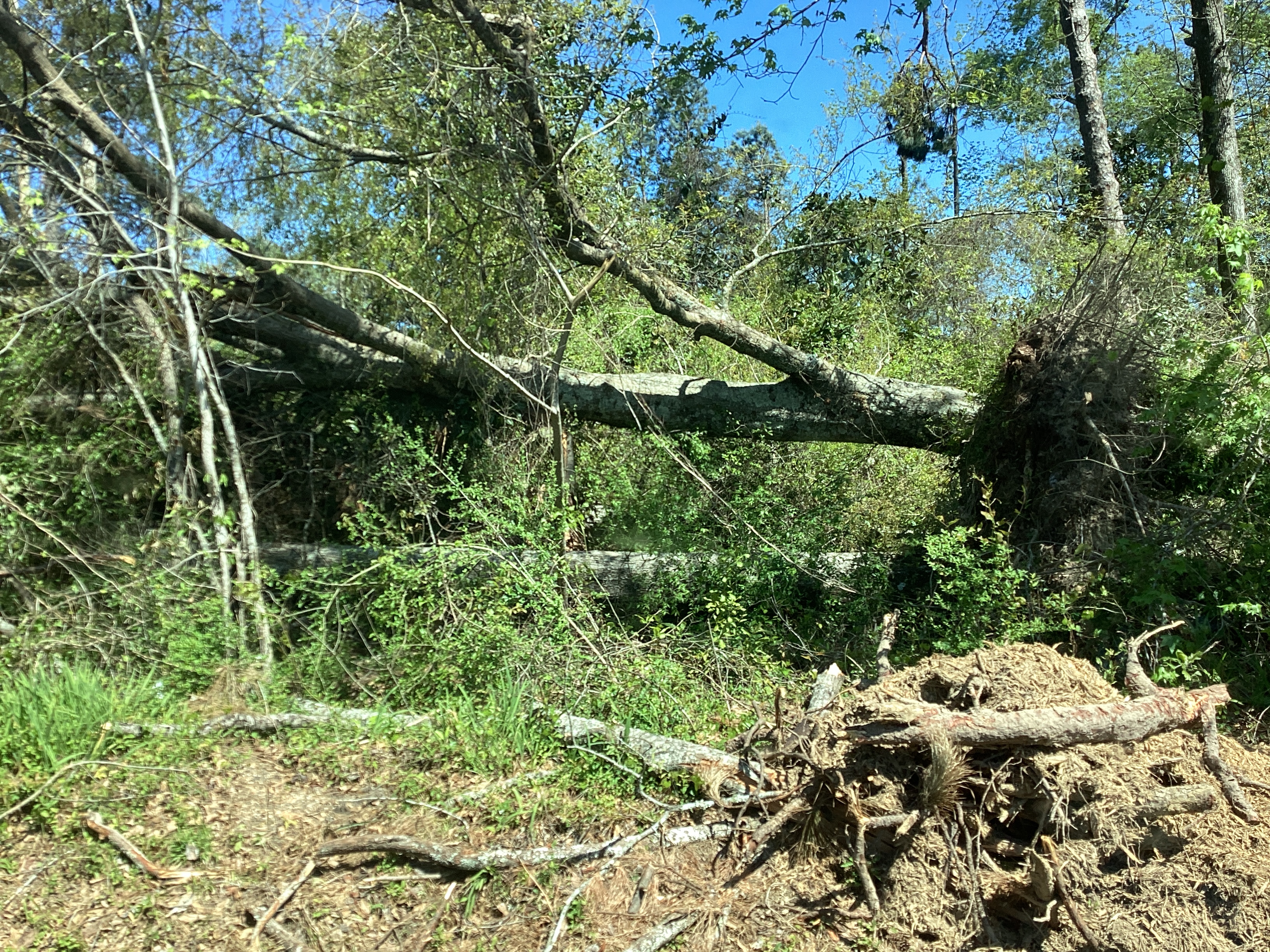
Denham Tornado (Wayne County, MS)
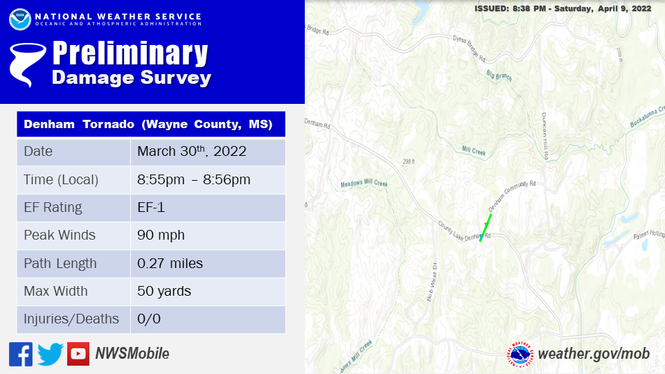
..Wayne County Northwestern Denham Tornado...

Rating:                 EF1
Estimated Peak Wind:    90 mph
Path Length /statute/:  0.27 miles
Path Width /maximum/:   50.0 yards
Fatalities:             0
Injuries:               0

Start Date:             03/30/2022
Start Time:             08:55 PM CDT
Start Location:         1 WNW Denham / Wayne County / MS
Start Lat/Lon:          31.6648 / -88.542

End Date:               03/30/2022
End Time:               08:56 PM CDT
End Location:           1 NW Denham / Wayne County / MS
End Lat/Lon:            31.6681 / -88.5396

Survey Summary:
A brief EF1 tornado began at 8:55 PM CDT on March 30th, 2022 along
County Lake Denham Road where it uprooted several softwood trees and
resulted in minor roof damage to nearby homes. The tornado crossed
Denham Community Road where it briefly intensified to remove half
the roofing material of a medium sized storage building. Several
goat houses were also destroyed. A few trees were snapped along
this road however damage quickly became spotty after the northeast
bend of Denham Community Road. The end point is estimated at the
tree line prior to this bend just past the EF1 damage point.
The photo below was taken during the tornado survey and shows the extent of the damage along the path of the tornado.
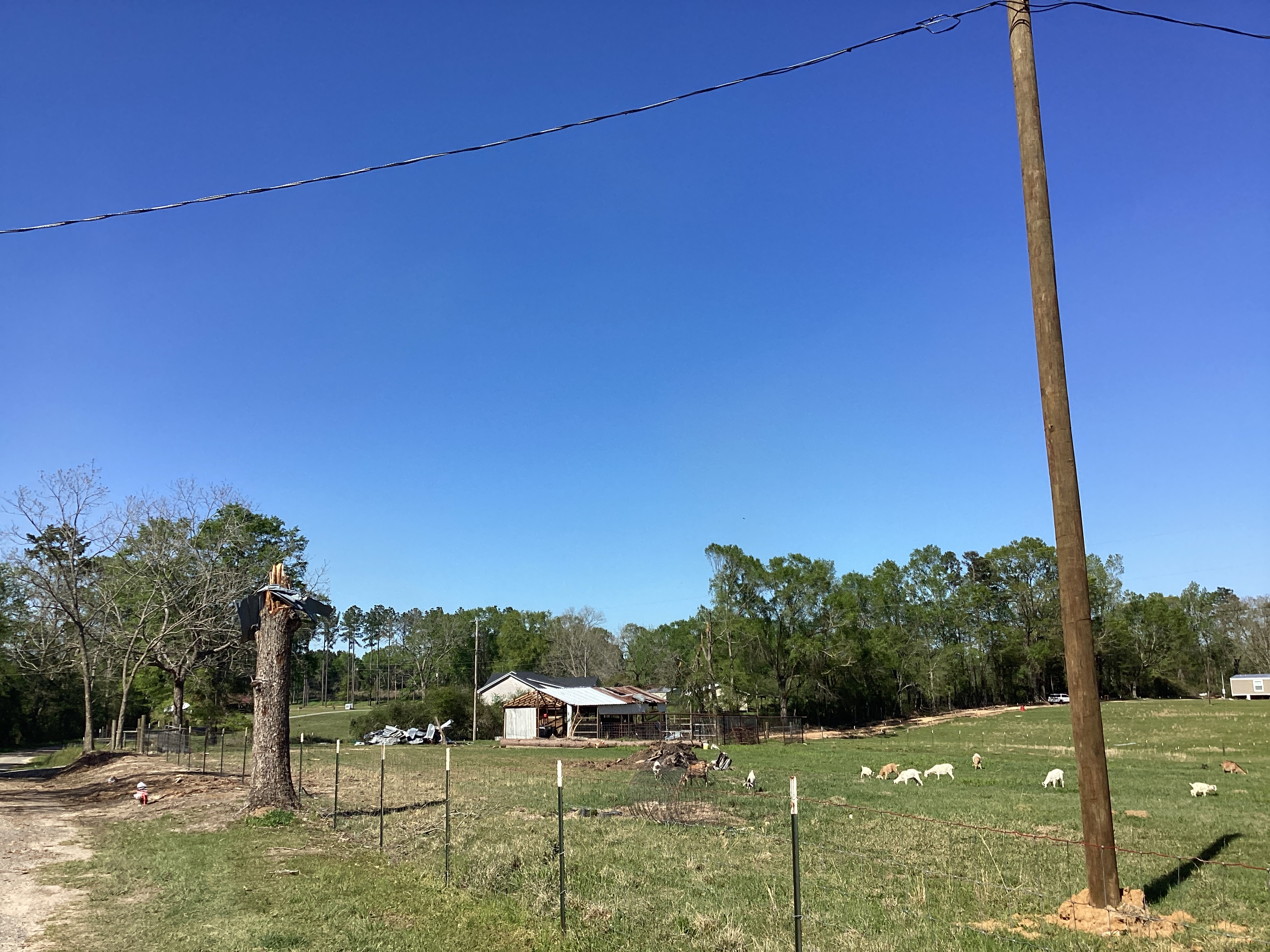
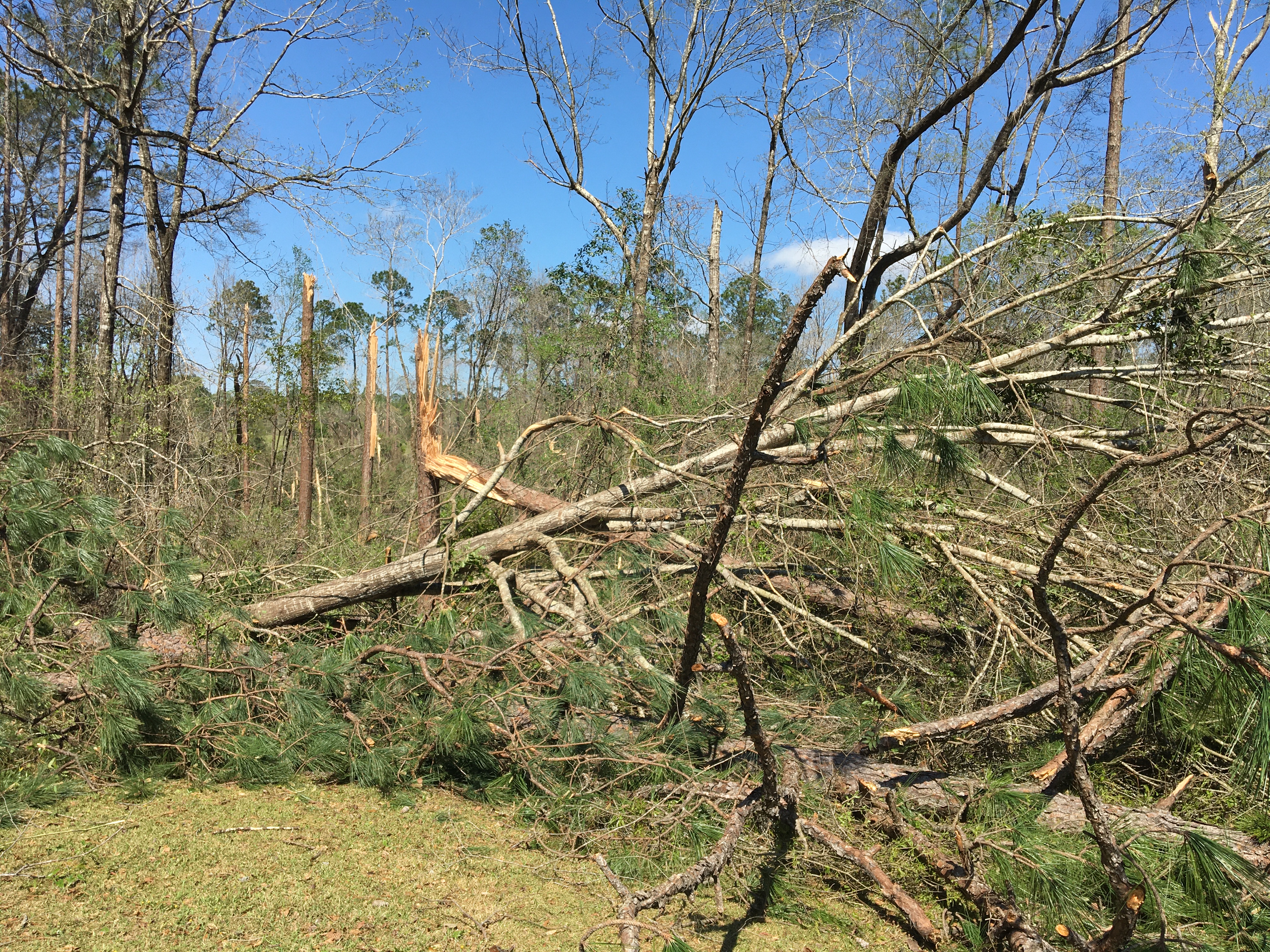
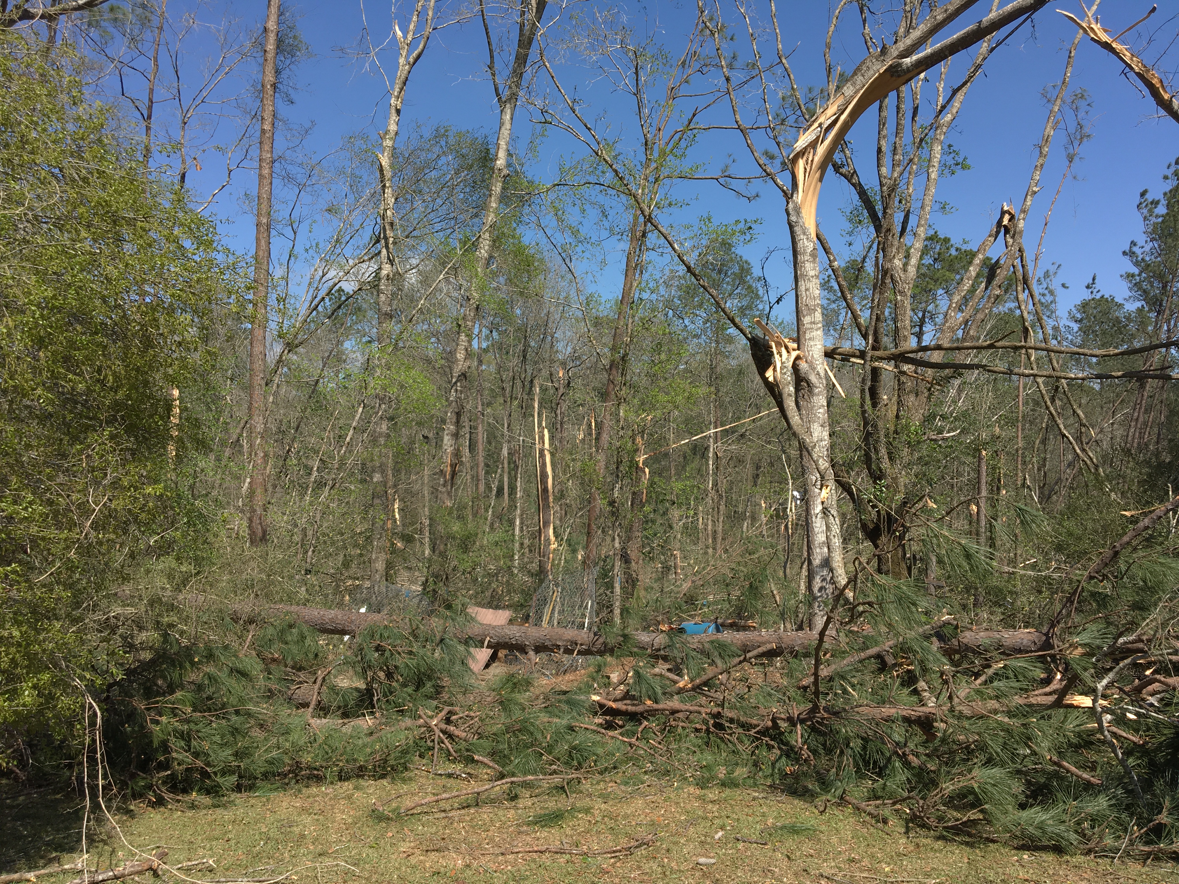
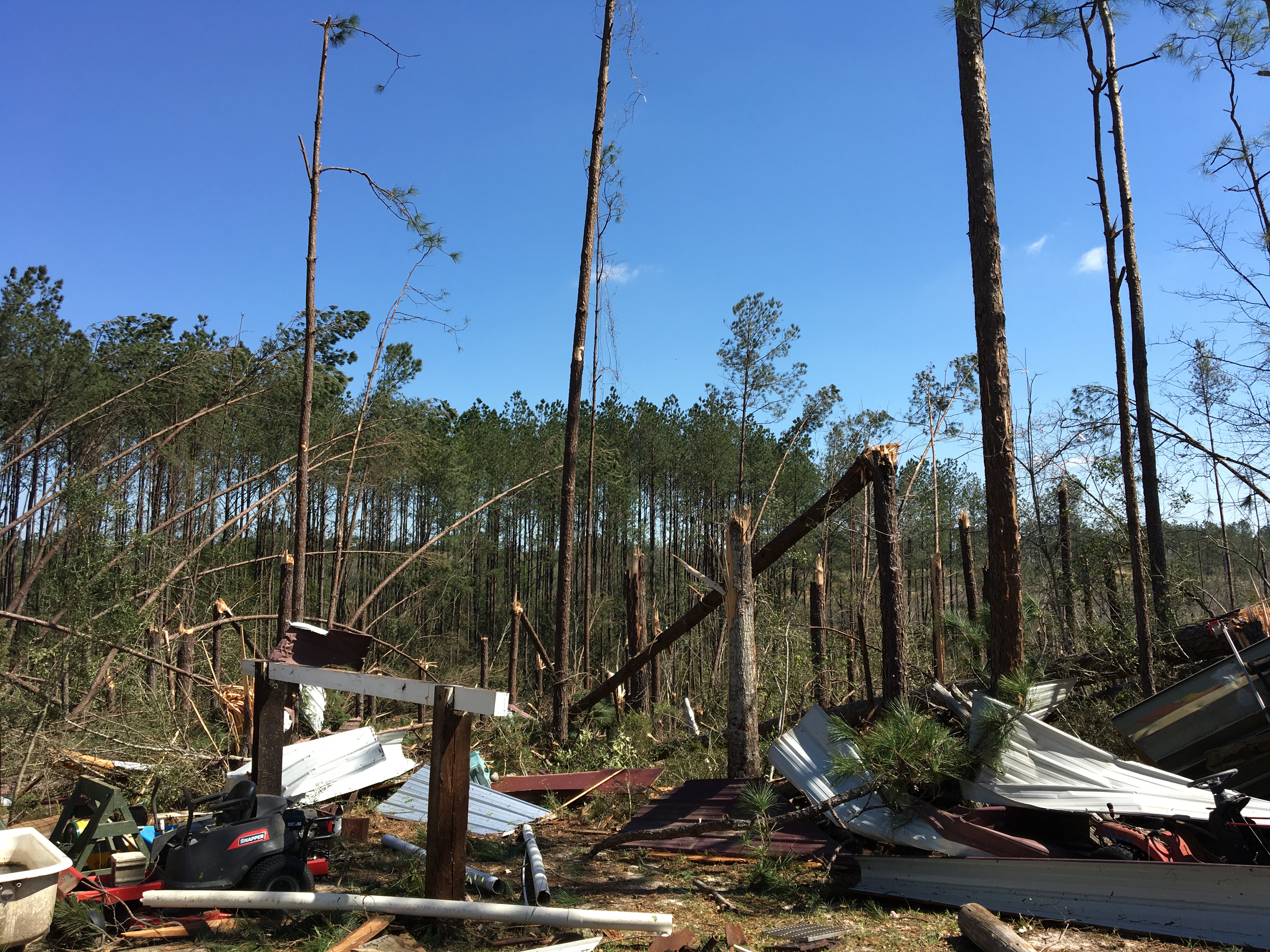
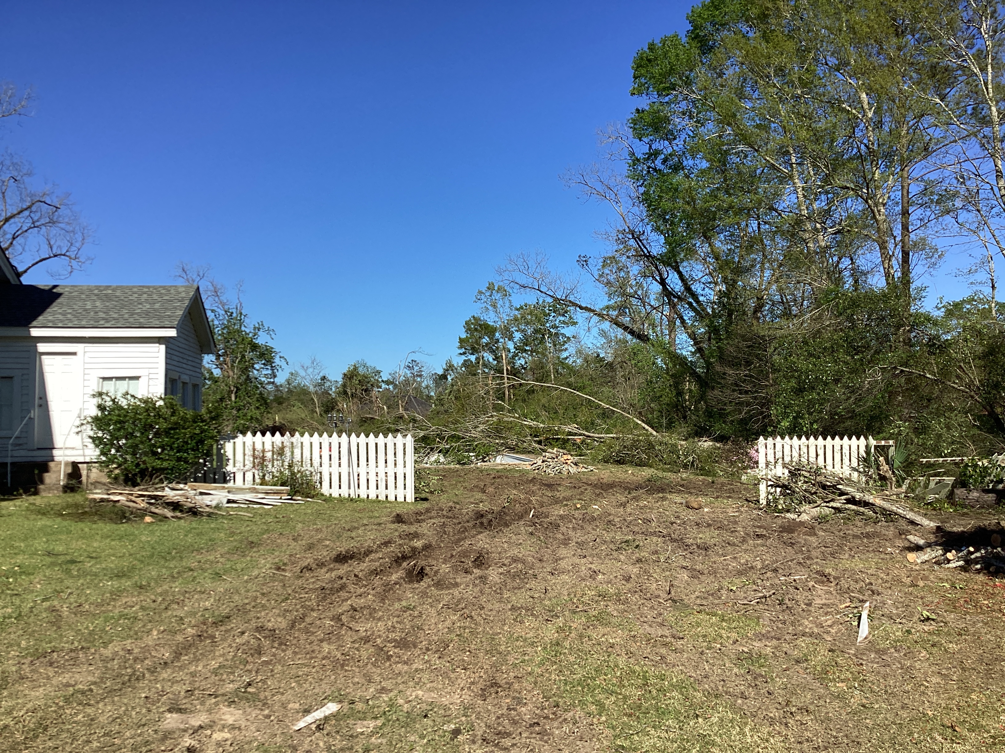
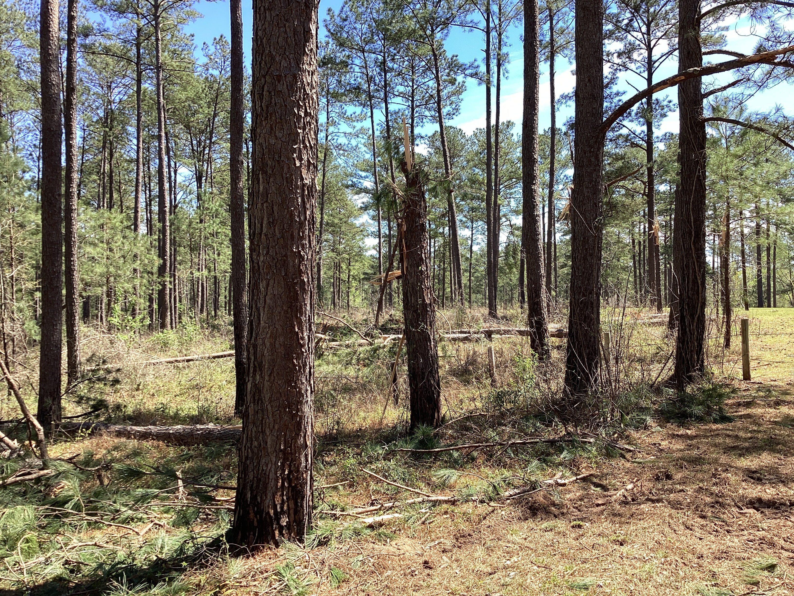
Southern Choctaw County, AL Tornado
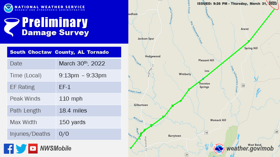
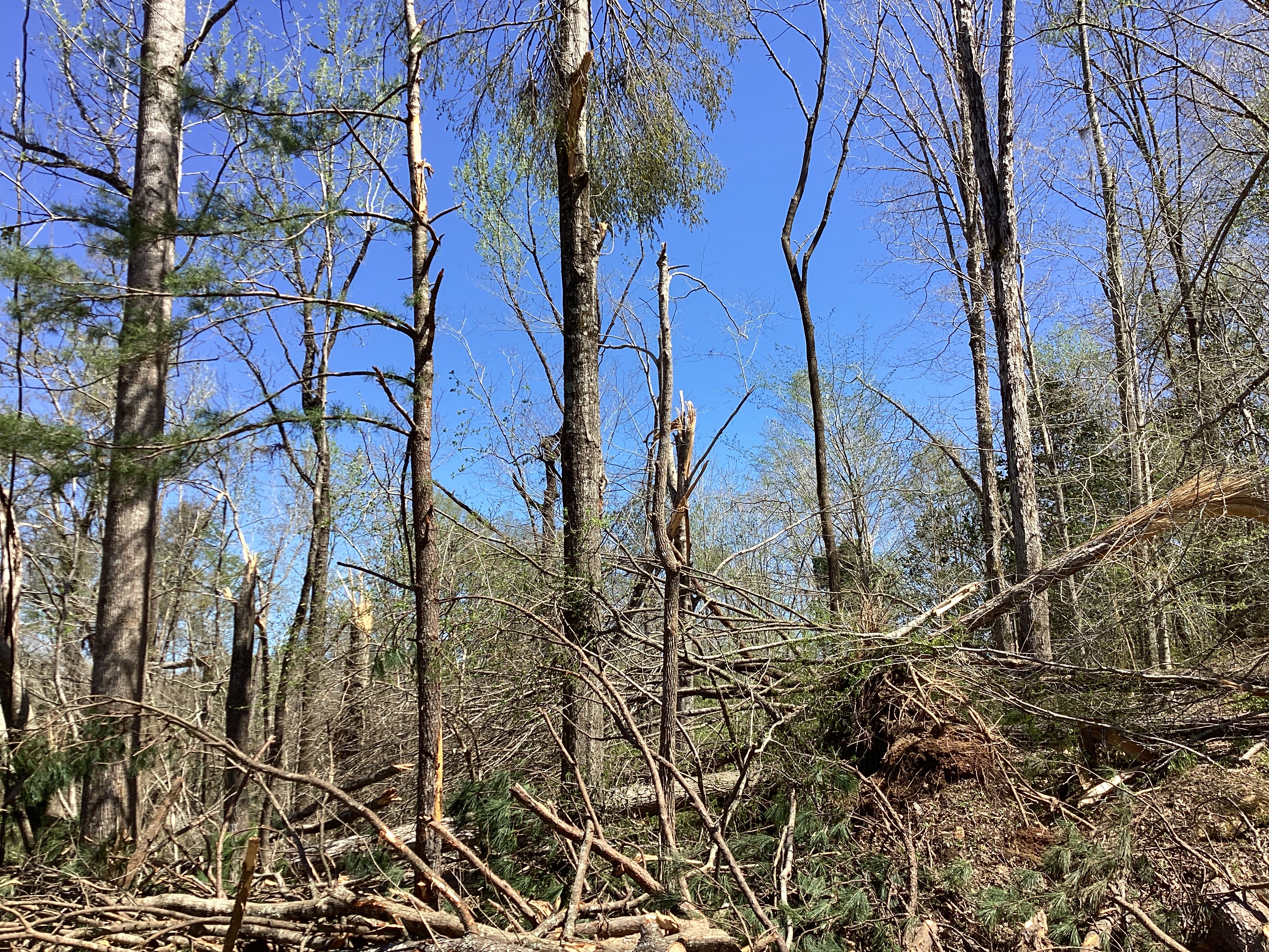
..Choctaw County Tornado...

Rating:                 EF1
Estimated Peak Wind:    110 mph
Path Length /statute/:  18.4 miles
Path Width /maximum/:   150.0 yards
Fatalities:             0
Injuries:               0

Start Date:             03/30/2022
Start Time:             09:13 PM CDT
Start Location:         1 WNW Souwilpa / Choctaw County / AL
Start Lat/Lon:          31.8259 / -88.3385

End Date:               03/30/2022
End Time:               09:33 PM CDT
End Location:           Slater / Choctaw County / AL
End Lat/Lon:            31.9941 / -88.099

Survey Summary:
An EF1 tornado began just southwest of Southern Choctaw High
School on 3/30/22 snapping multiple hardwood and softwood trees.
The beginning point is estimated just southwest of the high school
due to limited road access. Strong damaging winds accompanied the
rear flank downdraft associated with the tornado resulting in
damage to outdoor bleachers and small outbuildings by the sports
field. A bus was also overturned in the parking lot with minor
structural damage to the backside of the school. The tornado
continued tracking northeast, both widening and strengthening
impacting several homes and snapping/uprooting multiple trees and
snapping powerlines as it crossed Highway 17. This was the
strongest point along the tornado path with near 110mph winds. The
tornado continued tracking northeast causing more sporadic EF0 to
EF1 damage along the rest of its path to the Marengo County
border with damage generally limited to a few snapped/uprooted
softwood and hardwood trees, along with minor roof damage to a few
homes. The tornado began to strengthen and widen again as it
approached the Tombigbee River with the last accessible damage
point on Ararat Road where there was notable snapped
softwood/hardwood trees. The tornado likely continued northeast
into Marengo County. This area will be assessed by the Birmingham
NWS and they will provide additional information. The end point
listed here could be adjusted based on additional coordination
with NWS Birmingham.
The photos below were taken during the tornado survey across Choctaw County and show the extent of the damage along the long path of the EF-1 tornado.


Semmes Tornado #1 (Mobile County, AL)
.png)
.Semmes Tornado 1...

Rating:                 EF0
Estimated Peak Wind:    74 mph
Path Length /statute/:  0.5703 miles
Path Width /maximum/:   20.0 yards
Fatalities:             0
Injuries:               0

Start Date:             03/30/2022
Start Time:             10:41 PM CDT
Start Location:         4 WSW Semmes / Mobile County / AL
Start Lat/Lon:          30.7528 / -88.315

End Date:               03/30/2022
End Time:               10:43 PM CDT
End Location:           3 WSW Semmes / Mobile County / AL
End Lat/Lon:            30.758 / -88.3076

Survey Summary:
A brief tornado touched down near Ellen Drive, resulting in the
loss of some shingles on a nearby home, a blown over fence, and
metal roofing from a shed which was tossed and wrapped around a
street sign. The width of the convergent pattern was really narrow
at this point, around 20 yards. The tornado then traveled
northeast across Howells Ferry Road and just east of Wulff Road
where the roof of a barn and a greenhouse tent were damaged, along
with metal roofing that was blown off a shed. Additionally, there
were large trees that were snapped. The tornado then likely
lifted shortly after.
The photos below were taken during the tornado survey in the Semmes community and show the extent of the damage along the path of the tornado.
Semmes Tornado #2 (Mobile County, AL)
.png)
.Semmes Tornado 2...

Rating:                 EF0
Estimated Peak Wind:    80 mph
Path Length /statute/:  0.714 miles
Path Width /maximum/:   30.0 yards
Fatalities:             0
Injuries:               0

Start Date:             03/30/2022
Start Time:             10:43 PM CDT
Start Location:         3 W Orchard / Mobile County / AL
Start Lat/Lon:          30.7246 / -88.2514

End Date:               03/30/2022
End Time:               10:44 PM CDT
End Location:           3 WNW Orchard / Mobile County / AL
End Lat/Lon:            30.7347 / -88.2489

Survey Summary:
Another tornado began south of Howells Ferry Road, east of
Howells Lane. A couple trees were snapped in the residential area,
along with fencing down and the roof of an awning that was blown
down. A basketball hoop was knocked over into a brick pillar,
destroying the pillar. The storm progressed north-northeast and
uprooted one or two large trees and caused several snapped trees.
Minor roof damage was noted to a nearby home along with bent
garage doors as well. The tornado likely continued north-northeast
over more forest and dissipated possibly over an adjacent
landfill. Debris from this landfill was tossed into upstream
residential areas.
The photos below were taken during the tornado survey in the Semmes community and show the extent of the damage along the path of the tornado.

State Line Tornado (Mobile County, AL)
.png)
.State Line Road Tornado...

Rating:                 EF0
Estimated Peak Wind:    75 mph
Path Length /statute/:  1.9 miles
Path Width /maximum/:   50.0 yards
Fatalities:             0
Injuries:               0

Start Date:             03/30/2022
Start Time:             10:30 PM CDT
Start Location:         4 SW Tanner Williams / Jackson County /
MS
Start Lat/Lon:          30.6894 / -88.4184

End Date:               03/30/2022
End Time:               10:34 PM CDT
End Location:           2 WSW Tanner Williams / Mobile County /
AL
End Lat/Lon:            30.7131 / -88.4033

Survey Summary:
A brief tornado touched down near Harry Pierce Road and moved
northeast into Alabama and lifted just east of State Line Road.
This was mostly due to tree damage and seeing a debris signature
on radar.
The photo below was taken during the tornado survey near the state line and shows the extent of the damage along the path of the tornado.
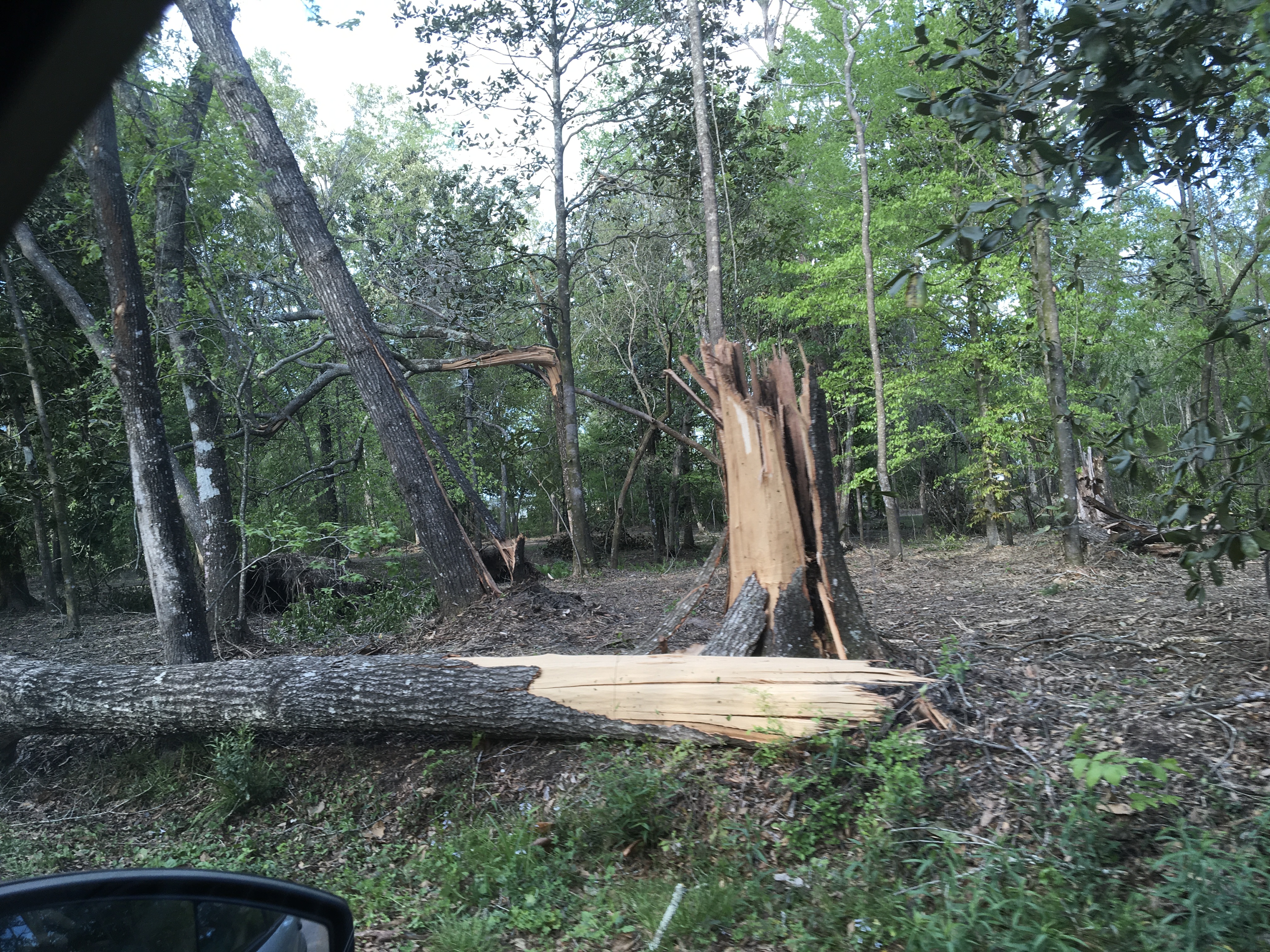
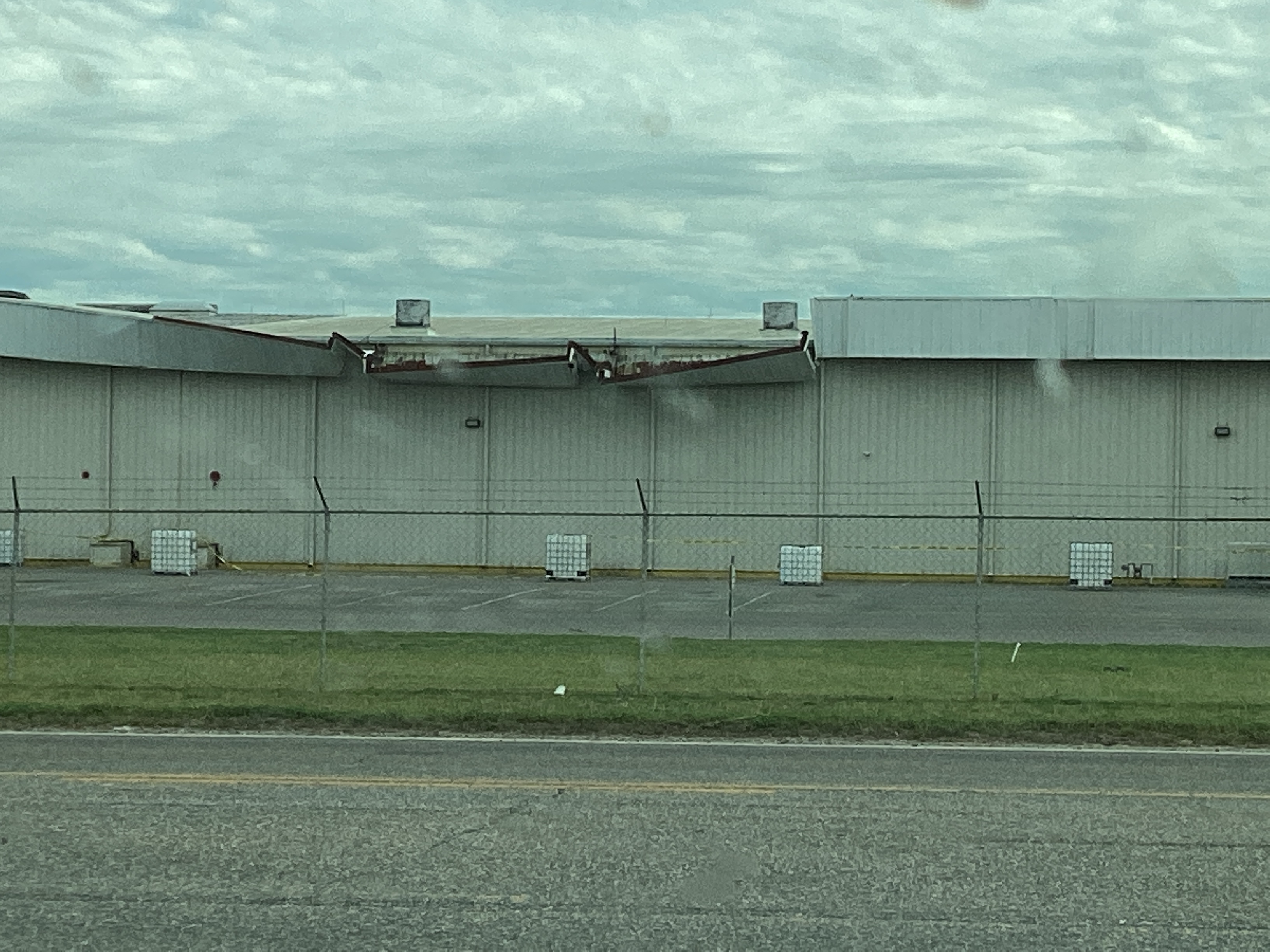
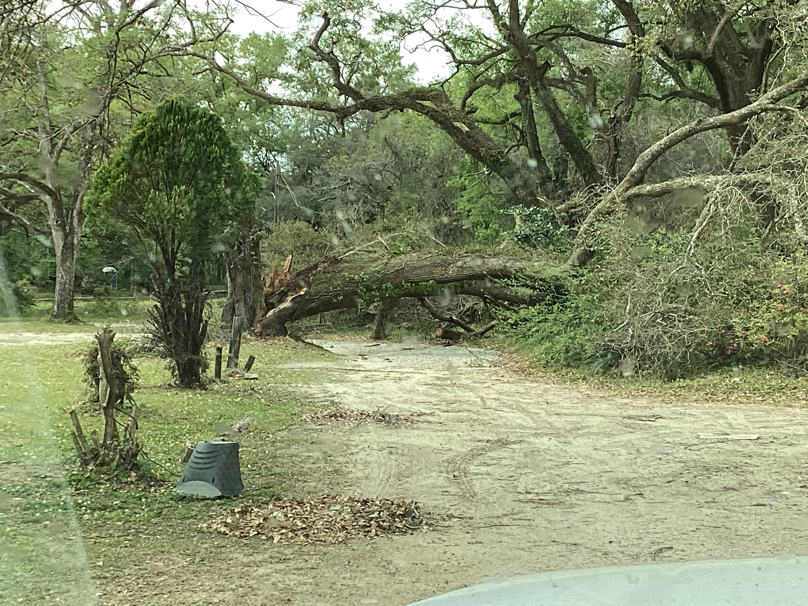
Theodore Tornado (Mobile County, AL)
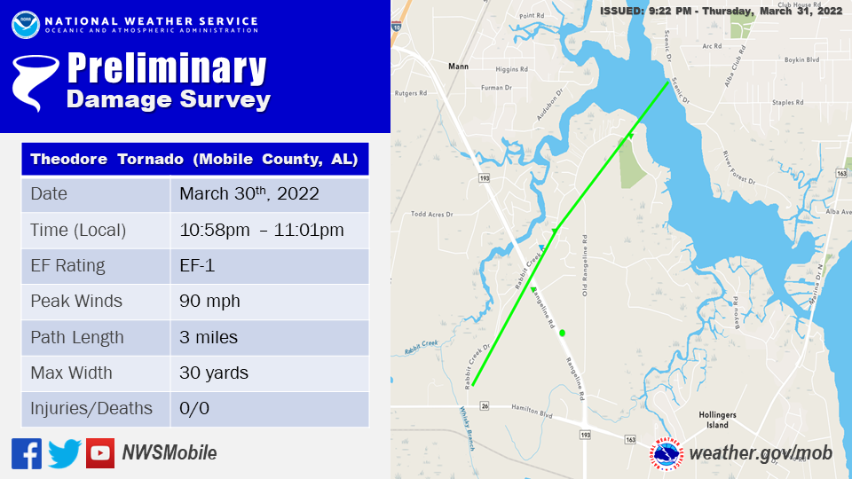
.Theodore Tornado...

Rating:                 EF1
Estimated Peak Wind:    90 mph
Path Length /statute/:  3.0203 miles
Path Width /maximum/:   30.0 yards
Fatalities:             0
Injuries:               0

Start Date:             03/30/2022
Start Time:             10:58 PM CDT
Start Location:         2 ENE Theodore / Mobile County / AL
Start Lat/Lon:          30.557 / -88.1414

End Date:               03/30/2022
End Time:               11:01 PM CDT
End Location:           2 E Mann / Mobile County / AL
End Lat/Lon:            30.5915 / -88.1104

Survey Summary:
The tornado began near Rabbit Creek Drive and progressed
northeast over Rangeline Road, snapping several power poles along
the way. Strong straight-line winds, likely nearing 100 mph,
snapped several other power poles along a half mile stretch of
Rangeline Road south of the main circulation. It continued
northeast on Rabbit Creek Drive and caused minor damage to roofs
(missing shingles) and tree damage. Several trees were snapped and
a street sign was knocked down with another bent. The most
significant damage occurred near the Dog River, where multiple
trees were snapped near the base and some were uprooted. At least a
couple more power poles were snapped near the top, likely due to
a combination of trees falling on the lines and tornadic winds.
The photos below were taken during the tornado survey in the Theodore community and show the extent of the damage along the path of the tornado.
Point Clear Tornado (Baldwin County, AL)
![]()
Public Information Statement
National Weather Service Mobile AL
749 PM CDT Fri Apr 1 2022

...NWS Damage Survey for 03/30/22 Point Clear AL Tornado Event...

..Point Clear, AL Tornado...

Rating:                 EF0
Estimated Peak Wind:    80 mph
Path Length /statute/:  0.55 miles
Path Width /maximum/:   50.0 yards
Fatalities:             0
Injuries:               0

Start Date:             03/30/2022
Start Time:             11:22 PM CDT
Start Location:         1 SSE Point Clear / Baldwin County / AL
Start Lat/Lon:          30.4668 / -87.9152

End Date:               03/30/2022
End Time:               11:23 PM CDT
End Location:           1 E Point Clear / Baldwin County / AL
End Lat/Lon:            30.4712 / -87.9075

Survey Summary:
A brief EF0 tornado began near Grass Road and tracked northeast, crossing Calloway
Drive. The tornado lifted by the time it reached Provencher Road just south of
County Road 32. The tornado produced sporadic pine tree damage along its path.
Rosinton Tornado (Baldwin County, AL)

.Rosinton Tornado...

Rating:                 EF0
Estimated Peak Wind:    75 mph
Path Length /statute/:  1.34 miles
Path Width /maximum/:   30 yards
Fatalities:             0
Injuries:               0

Start Date:             03/30/2022
Start Time:             11:50 PM CDT
Start Location:         4 ENE Rosinton / Baldwin County / AL
Start Lat/Lon:          30.6353 / -87.6288

End Date:               03/30/2022
End Time:               11:53 PM CDT
End Location:           5 ENE Rosinton / Baldwin County / AL
End Lat/Lon:            30.6527 / -87.6187

Survey Summary:
A brief, weak EF0 tornado with winds upwards of 75mph occurred in
Baldwin County, Alabama just northeast of Rosinton 3/30/22. The
tornado began in a limited access area where a couple freshly
snapped tops to pine trees were noted across the field. Due to
limited road access and brevity of the tornado, the path and end
point are estimated by radar debris signature and velocity couplet
duration.
Camden Tornado (Wilcox County, AL)
.png)
.Wilcox County Tornado...

Rating:                 EF1
Estimated Peak Wind:    107 mph
Path Length /statute/:  0.7692 miles
Path Width /maximum/:   170.0 yards
Fatalities:             0
Injuries:               0

Start Date:             03/30/2022
Start Time:             11:09 PM CDT
Start Location:         1 NW Camden / Wilcox County / AL
Start Lat/Lon:          32.002 / -87.302

End Date:               03/30/2022
End Time:               11:11 PM CDT
End Location:           1 N Camden / Wilcox County / AL
End Lat/Lon:            32.0063 / -87.2899

Survey Summary:
The tornado began along Mayo street in Camden where a couple
trees were uprooted. The tornado quickly intensified as it moved
Northeast across Broad St. with numerous uprooted large hardwood
and softwood trees. A strong convergent pattern was noted at this
location. Peak intensity occurred as it crossed Pine Ridge Road and
Rolling Hills Dr. where several large hardwoods were snapped and
most other trees were uprooted. The tornado than began to weaken
as it crossed Highway 10. The tornado lifted just northeast of
Elizabeth Avenue but not before causing damage to a small barn and
uprooting some trees. Significant wind damage still occurred along
Elizabeth avenue southeast of the circulation where several large
hardwoods were uprooted or snapped. However, this was determined
to be straight-line wind damage given divergent pattern to the
damage right of the parent circulation.
The photos below were taken during the tornado survey in the Camden community and show the extent of the damage along the path of the tornado.
Whatley Tornado (Clarke County, AL)
.png)
.Clarke County Tornado...

Rating:                 EF1
Estimated Peak Wind:    100 mph
Path Length /statute/:  0.1529 miles
Path Width /maximum/:   75.0 yards
Fatalities:             0
Injuries:               0

Start Date:             03/30/2022
Start Time:             10:33 PM CDT
Start Location:         1 WNW Whatley / Clarke County / AL
Start Lat/Lon:          31.6641 / -87.7298

End Date:               03/30/2022
End Time:               10:34 PM CDT
End Location:           1 NW Whatley / Clarke County / AL
End Lat/Lon:            31.665 / -87.7274

Survey Summary:
The brief tornado began along Ft. Sin Quefield Road where several
branches and a couple trees were snapped. The tornado then
crossed the road and removed most of the roof and some exterior
metal walls of a large metal building structure. Several softwood
uproots and a couple softwood snaps were noted at this location. A
large swath of wind damage with divergent pattern extended South
along Ft. Sin Quefield Road with several snapped softwoods noted.
The tornado then lifted quickly as it approached Highway 84 where
only sporadic large tree branches were snapped. This tornado was
associated with a larger swath of 90 to 95 mph straight-line wind
damage with sporadic snapped softwoods.
The photos below were taken during the tornado survey in the Whatley community and show the extent of the damage along the path of the tornado.

Gonzalez Tornado (Escambia County, FL)

.Gonzalez Tornado...

Rating:                 EF0
Estimated Peak Wind:    80 mph
Path Length /statute/:  0.32 miles
Path Width /maximum/:   50.0 yards
Fatalities:             0
Injuries:               0

Start Date:             03/31/2022
Start Time:             12:25 AM CDT
Start Location:         2 E Gonzalez / Escambia County / FL
Start Lat/Lon:          30.5751 / -87.261

End Date:               03/31/2022
End Time:               12:26 AM CDT
End Location:           2 E Gonzalez / Escambia County / FL
End Lat/Lon:            30.578 / -87.2571

Survey Summary:
A brief, weak EF0 tornado with winds upwards of 80mph began in
the Gonzalez area shortly after midnight on 3/31/22 impacting a
residential area from Chemstrand Road east northeast through
Caterpillar Lane and Crystal Drive. This tornado resulted in minor
damage to fencing, roofs, siding, and a couple uprooted/snapped
softwood trees in a weak convergent pattern along the damage path.
The tornado lifted at Crystal Drive.
The photos below were taken during the tornado survey in the Gonzalez community and show the extent of the damage along the path of the tornado.
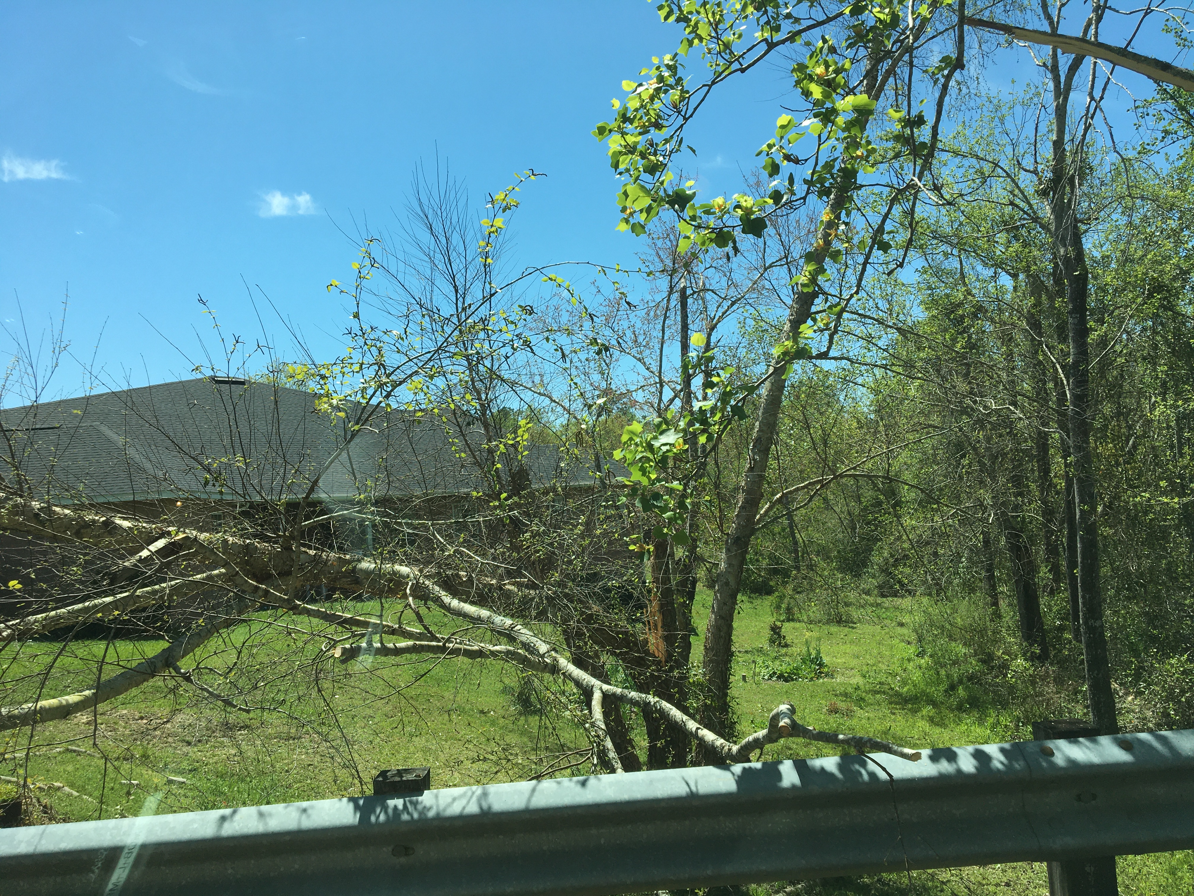
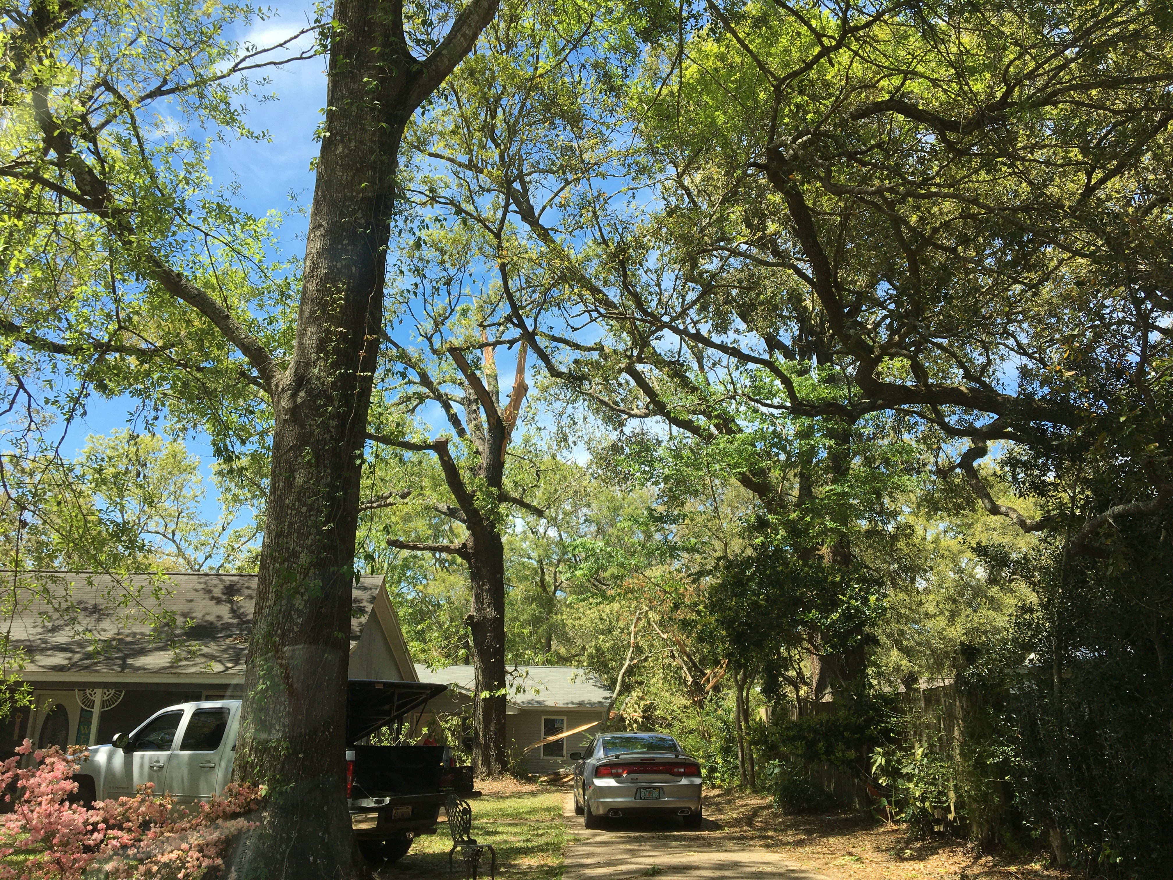
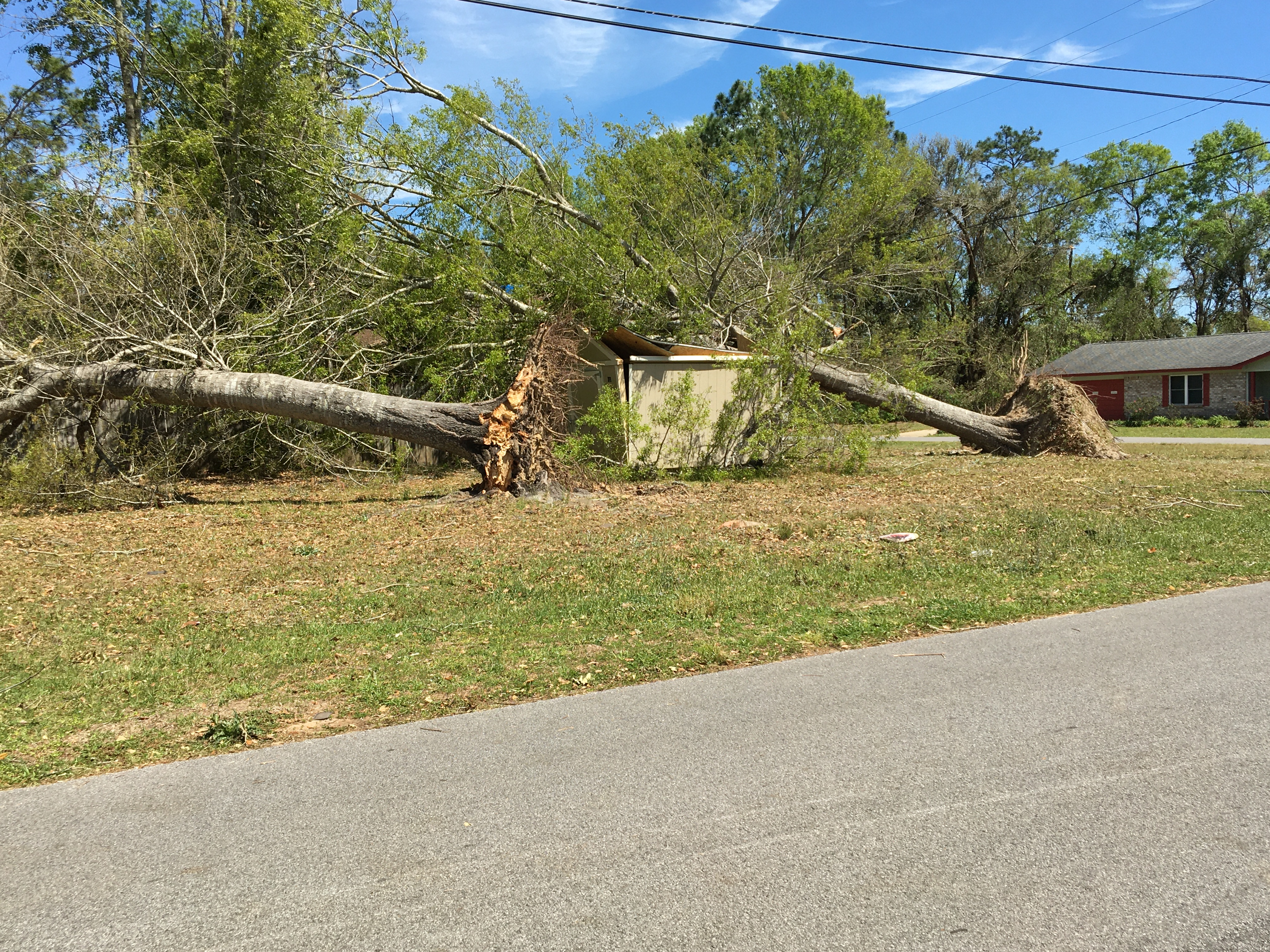
Pace Tornado (Santa Rosa County, FL)
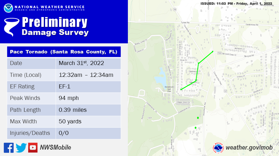
..Pace Tornado...

Rating:                 EF1
Estimated Peak Wind:    94 mph
Path Length /statute/:  0.39 miles
Path Width /maximum/:   50.0 yards
Fatalities:             0
Injuries:               0

Start Date:             03/31/2022
Start Time:             12:32 AM CDT
Start Location:         3 NNW Pace / Santa Rosa County / FL
Start Lat/Lon:          30.6415 / -87.1849

End Date:               03/31/2022
End Time:               12:34 AM CDT
End Location:           3 NNW Pace / Santa Rosa County / FL
End Lat/Lon:            30.6451 / -87.1806

Survey Summary:
A short duration EF1 tornado with winds upwards of 94mph impacted
the Pace area on 3/31/22. This tornado began on Dove Drive
impacting multiple residential structures resulting in notable
loss of roofing material along with many snapped/uprooted softwood
and hardwood trees. The tornado exited the community quickly
tracking just to the northwest of the Circle K on Quintette Road
where multiple trees were snapped and uprooted. The tornado lifted
at or near the Berryhill and Chumuckla Highway intersection where
the damage path ended.
The photos below were taken during the tornado survey in the Pace community and show the extent of the damage along the path of the tornado.
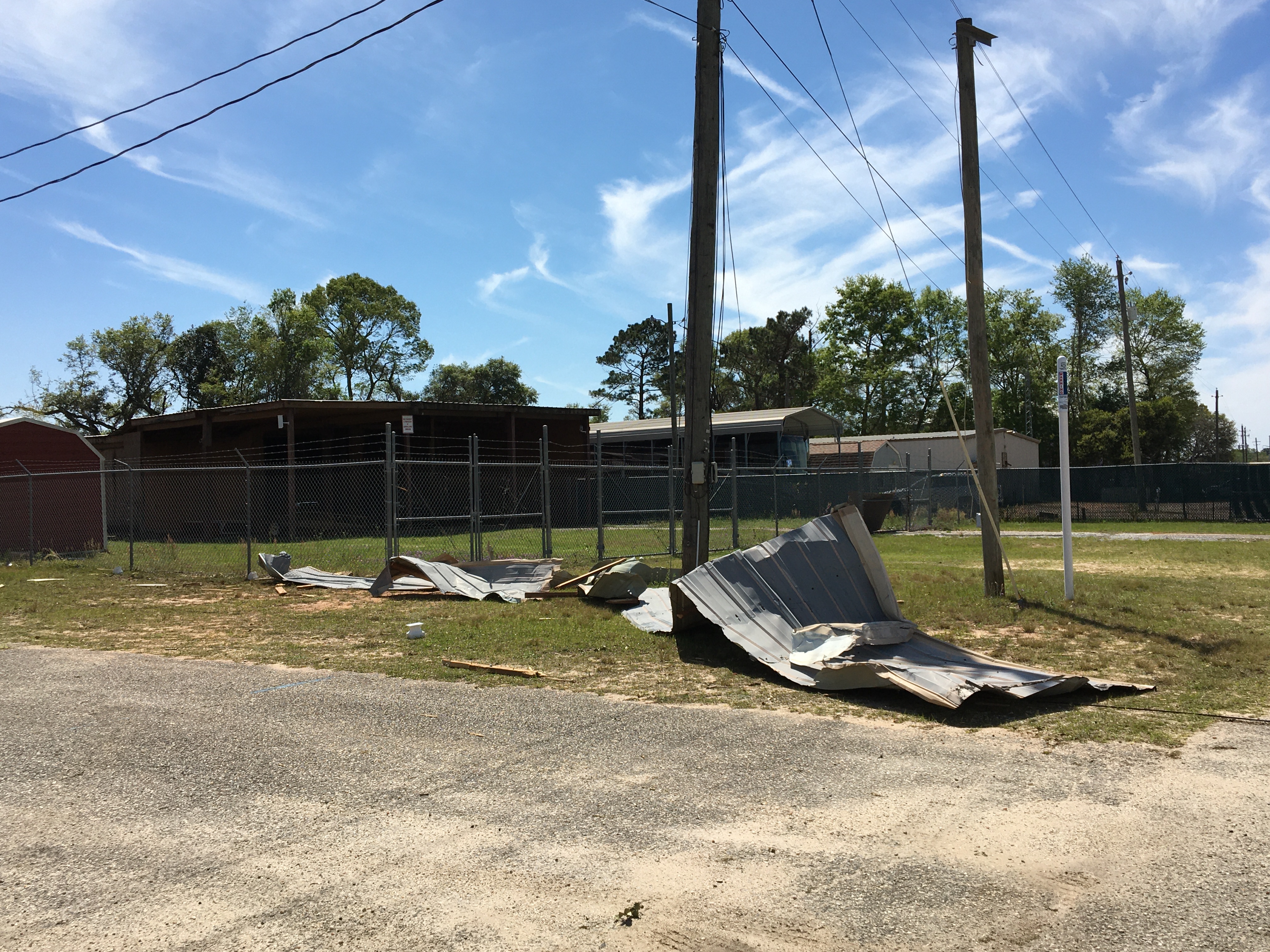
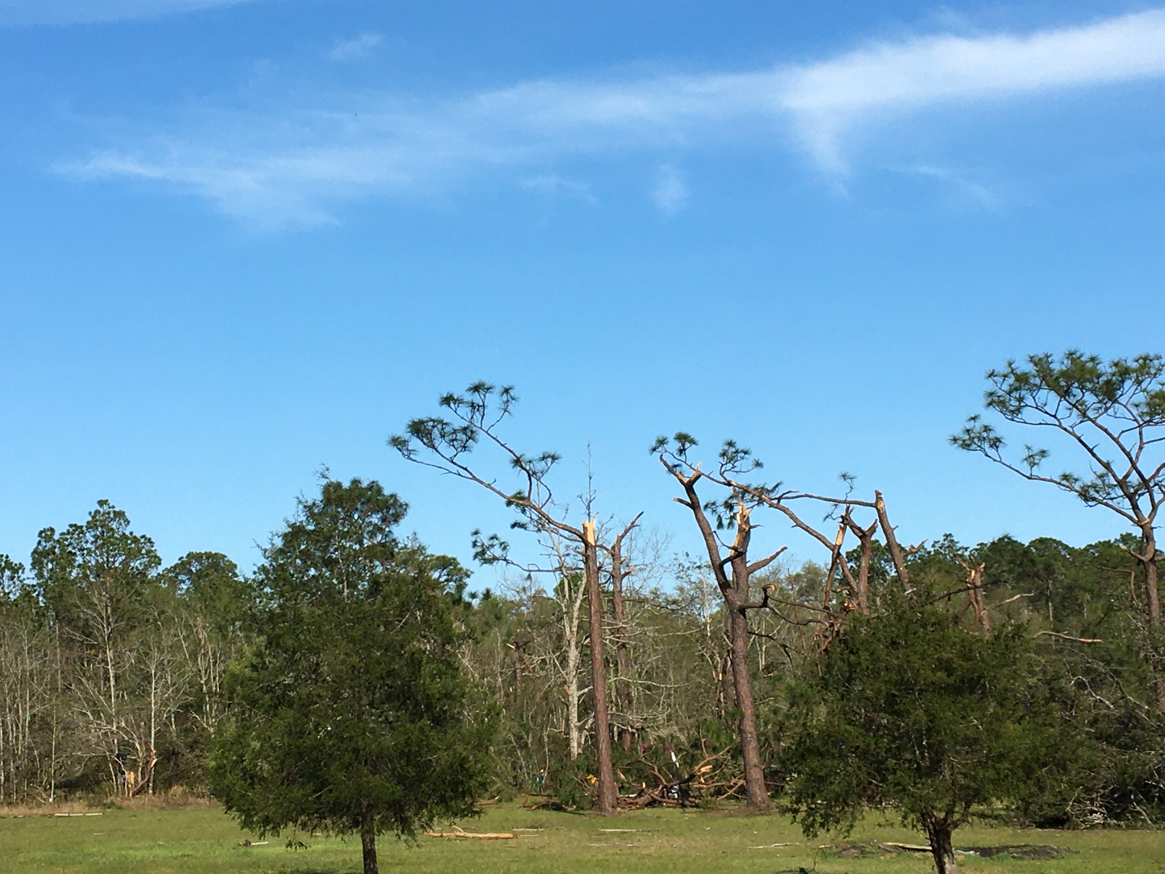
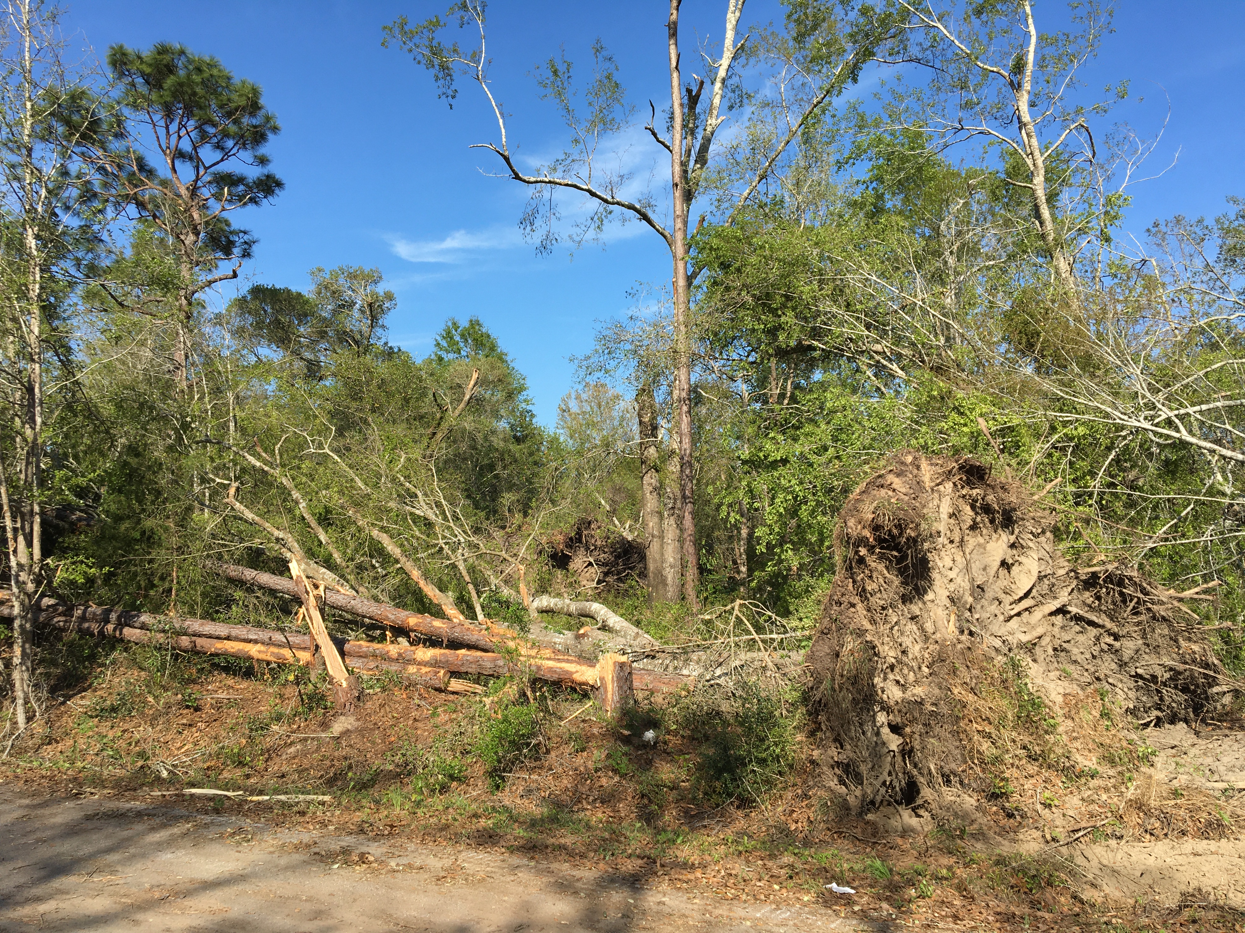
Avalon Tornado (Santa Rosa County, FL)
..Avalon Tornado...

Rating:                 EF1
Estimated Peak Wind:    104 mph
Path Length /statute/:  5.96 miles
Path Width /maximum/:   100.0 yards
Fatalities:             0
Injuries:               2

Start Date:             03/31/2022
Start Time:             12:37 AM CDT
Start Location:         2 SSW Mulat /  / FL
Start Lat/Lon:          30.52 / -87.1429

End Date:               03/31/2022
End Time:               12:47 AM CDT
End Location:           2 S Galt City / Santa Rosa County / FL
End Lat/Lon:            30.5653 / -87.06

Survey Summary:
An EF1 tornado began on 3/31/22 along the Escambia Bay Bridge of
I-10 overturning an eastbound semi-truck resulting in two
injuries. The tornado continued northeast moving onshore off of
Escambia Bay resulting in very sporadic minor tree damage around
North 6th Avenue. The tornado turned east northeast and picked up
in intensity as it uprooted and snapped numerous hardwood/softwood
trees and caused minor to moderate roofing damage to residential
homes. The tornado tracked northeast reaching its peak intensity
of 104mph along De La Rue Drive where a small tree stand had most
of its trees snapped with multiple uprooted and snapped trees in
its vicinity. The tornado continued northeast from here crossing
another small residential community located along Highland Lake Rd
into Edinburgh Castle Drive uprooting and snapping multiple trees
and removing some roofing material from residential homes. The
tornado cross Edinburgh Castle Drive where it impacted a
residential home which had a personal weather station located on
the back side of the house. The weather station measured a peak
wind gust of 97mph associated with the tornado. The home suffered
notable roof damage along with many of its windows blown out.
Several snapped and uprooted trees were also on the property. The
tornado continued east northeast crossing Florida 281, directly
impacting Avalon Utilities building removing some siding and
roofing material. The tornado likely continued to track northeast
of here, weakening as it did so across open fields and tree
stands. Due to limited road access, the end point of the tornado
is estimated based on the weakening of the couplet on radar and
the lack of any convergent wind damage on accessible roads to the
northeast.
The photos below were taken during the tornado survey in the Avalon community and show the extent of the damage along the path of the tornado.
Additional Information
SPC Storm Report Archive
NWS Local Write-Ups and Webpages:
NWS Jackson, MS
NWS New Orleans
NWS Birmingham
NWS Tallahassee
Acknowledgements: Page created by Morgan Barry (Forecaster), Christina Leach (Forecaster), & Jason Beaman (WCM). Page updated by Caitlin Baldwin (Forecaster).
LAST UPDATED: March 2024


 Follow us on YouTube