
Early Morning March Tornado Event
March 9, 2022
Summary of all Local Storm Reports (LSRs) on March 9th, as well as all the LSRs across the region for this event. Storm survey teams preliminarily concluded that there were 2 EF-1 tornadoes in our forecast area early on March 9th.
The data provided on this page are considered preliminary as we continue to analyze all available data. We will add more information to this page and social media as it becomes available. We thank you in advance for your patience.
Mobile County, AL Tornado

Public Information Statement
National Weather Service Mobile AL
140 PM CST Wed Mar 9 2022

...NWS Damage Survey for 03/09/22 Tornado Event...

..Southwest Mobile County Tornado...

Rating:                 EF1
Estimated Peak Wind:    90-100 mph
Path Length /statute/:  1.77 miles
Path Width /maximum/:   50.0 yards
Fatalities:             0
Injuries:               0

Start Date:             03/09/2022
Start Time:             12:42 AM CST
Start Location:         3 N Dees / Mobile County / AL
Start Lat/Lon:          30.6102 / -88.3371

End Date:               03/09/2022
End Time:               12:45 AM CST
End Location:           2 SSW Seven Hills / Mobile County / AL
End Lat/Lon:            30.6301 / -88.3189

Survey Summary:
The tornado touched down on Lakefront Ct where it produced very minor
tree damage, after which the tornado tracked off to the northeast.
The most significant structural damage occurred at a residence near
the intersection of Lakefront Dr and Dogwood Circle. Roof damage
and damage to multiple hardwood/softwood trees was noted. The tornado
then continued off to the northeast where it weakened slightly as it
crossed Scenic View Dr. It then continued northeast and increased in
strength as it approached Busby Rd where multiple softwood trees
were found snapped. The tornado lifted somewhere to the northeast of
Busby Rd before crossing Schmidt Ln and/or Johnson Rd where no damage
was found.

The team surveyed reports of damage on Repoll Rd, but only sporadic
minor wind damage was noted.


&&

EF Scale: The Enhanced Fujita Scale classifies tornadoes into the
following categories:

EF0...Weak......65 to 85 mph
EF1...Weak......86 to 110 mph
EF2...Strong....111 to 135 mph
EF3...Strong....136 to 165 mph
EF4...Violent...166 to 200 mph
EF5...Violent...>200 mph

NOTE:
The information in this statement is preliminary and subject to
change pending final review of the event and publication in NWS
Storm Data.
The photo below was taken during the tornado survey in Mobile County and shows the extent of the damage along the path of the tornado.

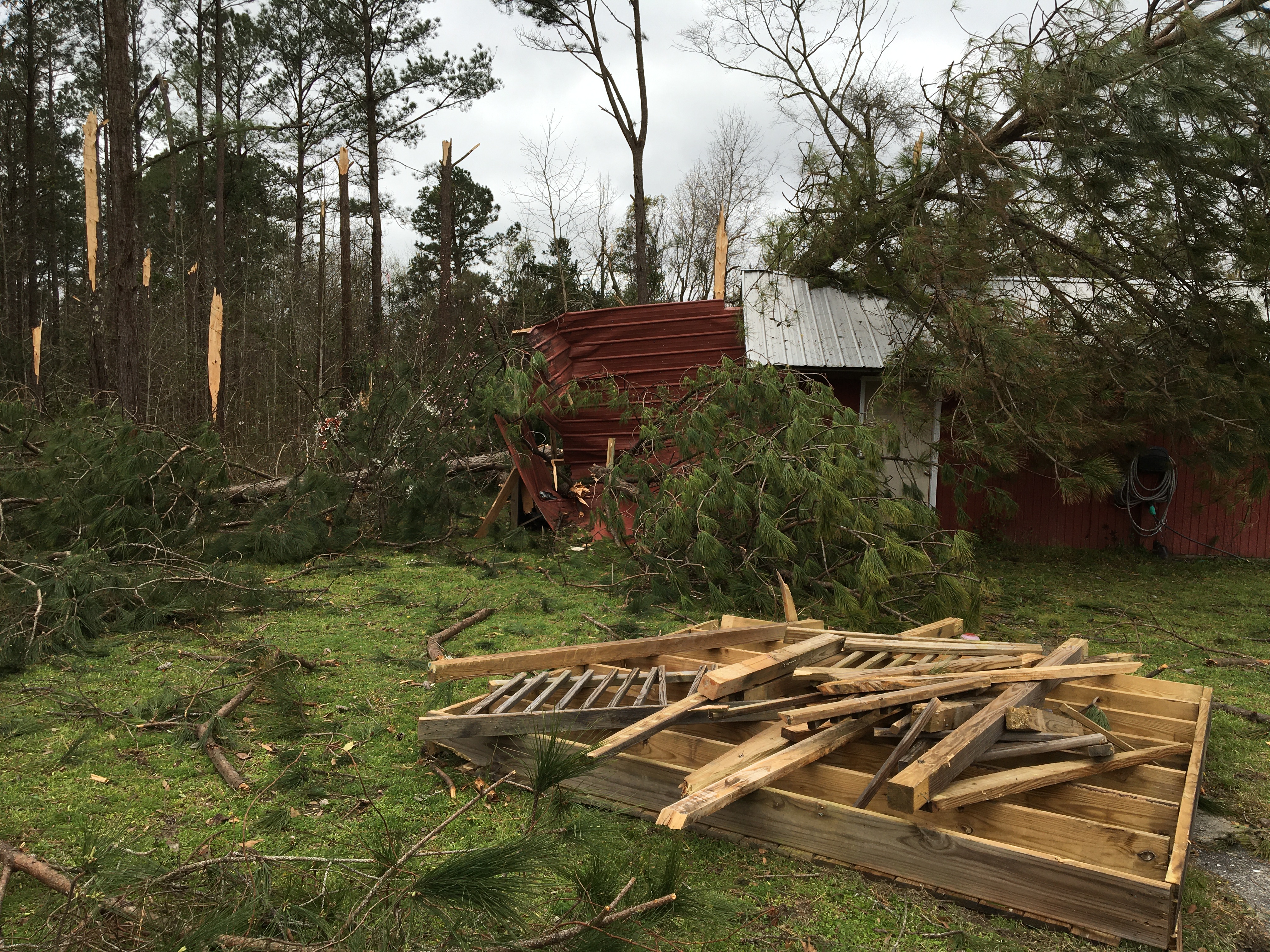
Conecuh County, AL Tornado
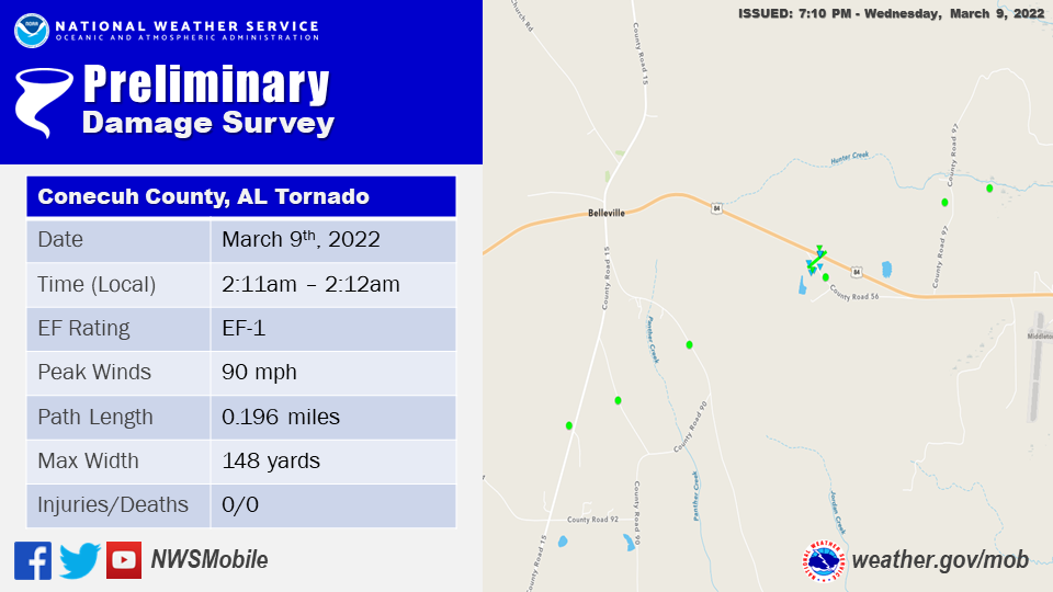
Public Information Statement
National Weather Service Mobile AL
705 PM CST Wed Mar 9 2022

...NWS Damage Survey for 03/09/22 Tornado Event...

..Conecuh County Tornado...

Rating:                 EF1
Estimated Peak Wind:    90 mph
Path Length /statute/:  0.196 miles
Path Width /maximum/:   148.0 yards
Fatalities:             0
Injuries:               0

Start Date:             03/09/2022
Start Time:             02:11 AM CST
Start Location:         2 E Belleville / Conecuh County / AL
Start Lat/Lon:          31.4245 / -87.0796

End Date:               03/09/2022
End Time:               02:12 AM CST
End Location:           2 E Belleville / Conecuh County / AL
End Lat/Lon:            31.4261 / -87.0769

Survey Summary:
A 2.5 mile long swath of straight line wind south of Belleville
preceded the brief Belleville tornado. The straight line wind
damage began to the west of CR 15, south of Belleville, and
continued to the northeast toward Highway 84. The straight line
wind damage may have started prior to CR 15, but the survey team
could not access areas further to the southwest. Several trees
were snapped and uprooted along the initial swath of straight line
wind damage. A brief tornado occurred just east of Belleville
along CR 56. Numerous pine trees were snapped along with several
hardwoods snapped and uprooted just south of CR 56. Three homes in
the area sustained minor roof damage with roof loss for several
sheds and storage buildings. Metal roof pieces were noted in
nearby trees and scattered along the path. A small flag pole was
bent to the ground and a nearby power line was down. The tornado
quickly moved northeast across Highway 84 where several more trees
were snapped. The tornado likely lifted somewhere just to the
north of Highway 84, to the east of Belleville. A path of straight
line wind was noted for at least another 1.5 miles to the
northeast of the tornado track where several more trees were
snapped and a couple of trees were uprooted.

&&

EF Scale: The Enhanced Fujita Scale classifies tornadoes into the
following categories:

EF0...Weak......65 to 85 mph
EF1...Weak......86 to 110 mph
EF2...Strong....111 to 135 mph
EF3...Strong....136 to 165 mph
EF4...Violent...166 to 200 mph
EF5...Violent...>200 mph

NOTE:
The information in this statement is preliminary and subject to
change pending final review of the event and publication in NWS
Storm Data.
The photos below were taken during the tornado survey in Conecuh County and show the extent of the damage along the path of the tornado.


Additional Information
Acknowledgements: Page created by Morgan Barry (Forecaster) and Christina Leach (Forecaster). Updated by Michael Mugrage (Forecaster).
LAST UPDATED: March 2024


 Follow us on YouTube