
Meteorological Summary for Northern and Central NM: From Drought to Deluge!
|
||||||||||||||
|
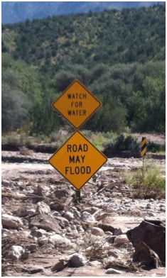
A deep upper level low pressure system that became relatively stationary over the Great Basin beginning on September 10th provided a steady stream of near record monsoon moisture over New Mexico. Multiple upper level disturbances pushed north and northeast across the region within the monsoon moisture plume through the 18th producing widespread historic rainfall amounts. This unprecedented heavy rain event resulted in saturated ground over much of New Mexico and directly contributed to an additional flooding event from strong to severe thunderstorms from September 18, 2013 through September 22, 2013. Details for each county in northern and central New Mexico, including photos, are available via the map at the bottom of this page.
|
||||||||||||||
|
The focus for widespread, long duration heavy rainfall waivered across the state during the 9-day period, ensuring that most areas would receive a healthy dose of much needed precipitation. The focus for heavy rain from the 10th to the 12th was primarily over southern and eastern New Mexico. After much of eastern New Mexico experienced a record to near record deluge of rainfall and flooding, the focus shifted into central and western New Mexico from the 13th to the 15th. Widespread heavy rains became more convective from the 16th to the 18th, focusing torrential rainfall over much smaller areas of the state. These convective rains on top of the saturated soil conditions left over from multiple days of widespread heavy rainfall exacerbated flooding concerns. Record to near record river flooding and areal flooding was observed in several areas of northern and central New Mexico by the end of the period, while numerous locations reported disastrous impacts from flash flooding as well. Total rainfall amounts over the 9-day period averaged 3 to 6 inches and in some areas just over 10 inches. Several river gauges reported record to near record crests and in a couple cases gauges were completely destroyed. Emergency management reported disastrous impacts to residential, commercial, and transportation infrastructure across northern and central New Mexico. Significant coverage of this event was broadcast by local and national media outlets. Social media coverage of the event was extraordinary as residents and visitors to the region shared valuable feedback with the National Weather Service. A total of 12 New Mexico counties, 4 cities and towns, and 4 pueblos, including the Navajo Nation, were included in a statewide disaster declaration. The New Mexico State Emergency Operations Center was in command at Level 2 operations for several days.
|
 |
|||||||||||||
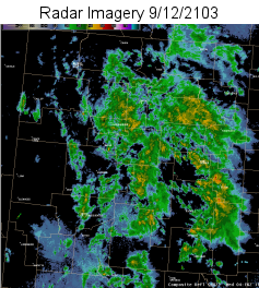
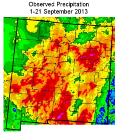
| Several impressive moisture surges were captured very well by satellite imagery. In the image on the left below, the stationary upper level low pressure can be seen over the Great Basin while a deep plume of monsoon moisture surges northward over New Mexico and Colorado. For a satellite loop of the entire event period visit the Albuquerque National Weather Service YouTube link available below the imagery. The center graphic is a composite radar reflectivity image valid on September 12, 2013. Note the widespread coverage of heavy rainfall over central and eastern New Mexico . A radar loop of the 7-day period from September 10 to September 16 is also available on YouTube beneath the imagery. The illustration on the right is a precipitation estimation for the 21-day period ending September 21, 2013 from the Advanced Hydrologic Prediction Service (AHPS). Note the most of the precipitation fell during the period from September 10-18. Precipitation estimates based on radar and gages from AHPS were astounding over New Mexico. Storm total precipitation amounts for this prolonged event were enough to wipe out yearly deficits over nearly all of the region, and in some cases modest surpluses were obtained, thereby improving the drought status across much of New Mexico. The precipitation estimates from AHPS will underestimate the rainfall in radar beam blocked areas, such as east of the Sandia Mountains,over much of the Four Corners and from the Guadalupe Mountains north to southwest Chaves County. | ||||||||||||||
 |
 |
 |
||||||||||||
| 10-Day Loop Available | 7-Day Loop Available | Full Image with PON Available | ||||||||||||
|
|
||||||||||||||
Hydrological Summary of Impacts by County
|
||||||||||||||
|
The clickable map below provides a more comprehensive overview of this historic event. Click on the desired county for rainfall summaries, impacts, hydrographs and photos. For a detailed tabular view of the same data shown in the map below, click here.
Last Updated: August 30, 2016 |
||||||||||||||
-->


.png)
 Follow us on YouTube