|
2012 Weather Year in Review Known for its often extreme and quickly changing weather, the Panhandles did not dissapoint in 2012. Though the quick pace of broken temperature records from last year wasn’t matched this year, the Panhandles experienced the second warmest year on record. Following last year’s extreme heat, this December also concludes the warmest two- and three-year stretches on record. Precipitation in most locations across the area was nearly double 2011’s record low amounts, though these figures were still only roughly half of the normal amounts. Beneficial late-winter and early-spring rains helped most of the area see short term recovery from the ongoing drought, though a dry summer and autumn have left mostly extreme to exceptional drought across the Panhandles. This was a relatively quiet year for severe weather events, as the ongoing drought limited the needed moisture on many occasions. Rare cool-season severe weather events did lead, however, to both the earliest and latest confirmed tornadoes on record in the 23 counties of our forecast area. The earliest tornado on record, rated EF-1, occurred a few miles south of Miami, TX shortly after midnight on February 3rd. This is only the 4th known February tornado for this area. The rest of the spring and summer saw several severe thunderstorms, with wind gusts between 80 to 90 mph and hail as big as softballs. In addition, a massive hail storm on April 11th shut down U.S. Highway 287 20 miles north of Amarillo due to hail drifts 3-4 ft. high. Finally, the year wrapped up with the area’s first ever confirmed December tornadoes. Three brief EF-0 tornadoes were produced on December 14th as a cold front swept rapidly across the Panhandles. Once again, Panhandle residents were lucky enough to see another White Christmas which was the first back to back White Christmases since 1894 and 1895.
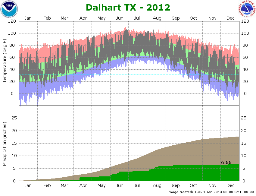
YEAR 2012 SUMMARY FOR AMARILLO High for the year: 107° F, August 3rd
Low for the year: 8° F, December 26th
Average High Temperature: 76.0° F (5.0° F above normal /all-time record for warmest)
Average Low Temperature: 46.8° F (3.0° F above normal)
Average Annual Temperature: 61.4 F (4.0° F above normal / 2nd warmest all-time record)
Annual precipitation: 12.33 inches (8.03 inches below normal)
Annual snowfall: 4.9 inches (12.9 inches below normal)
Days with temperature ≥ 100 degrees: 24 (3rd most 100 degree days)
Tornadoes: 6 Total – 5 EF-0 and 1 EF-1 (earliest and latest on record)
Climate Graphs for 2012
Top 5 Regional Weather Events of 2012
January Hi: 72° F, 30th Low: 16° F, 12th Average: 42.2° F (5.2° F above normal) Precipitation: 0.05 inches (0.67 inches below normal) Snowfall: 0.0 inches Records: The was the 10th warmest January on record
January kicked off the start of a very warm and dry year with a sign of things to come as it was the 10th warmest January on record. Very little precipitation fell this month with only 0.05 inches of rain and no snow falling in Amarillo. La Niña was still in effect at this time which continued the warm and dry conditions from 2011; this was signaled by the fact that the temperature for the month was 5.2 degrees above normal. February Hi: 76° F, 22nd Low: 13° F, 8th Average: 40.2° (0.1° below normal) Precipitation: 0.63 inches (0.07 inches above normal) Snowfall: 2.6 inches Records: The earliest tornado on record for the forecast area was reported south of Miami, TX on the 3rd. Tornadoes: 1 total - 1 rated EF1. Weather started to become more interesting in February with precipitation finally coming in above normal with 0.63 inches of rain (this is 0.07 inches above normal). Amarillo also received its first snow of the calendar year and ended the month with 2.6 inches of snow. Even though this number seems low, February would go on to be the snowiest month of 2012. With all of this precipitation, the severe weather season kicked off much earlier than it had ever before. Just after midnight on February 3rd an EF-1 tornado touched down near Miami in Roberts County. This marked the earliest a tornado had been recorded in a calendar year, and would bookend the latest tornadoes recorded in the Panhandles when they occurred in December. March Hi: 89° F, 31st Low: 21° F, 3rd Average: 56.4° F (8.5° F above normal) Precipitation: 1.16 inches (0.23 inches below normal) Snowfall: 0.2 inches Records: This was the third warmest March on record. Set the record high temperature of 84° F on the 15th. Set the record high temperature of 87° F on the 16th. Set the record high temperature of 86° F on the 24th. Tied the record high temperature of 87° F on the 29th. Tied the record warm low temperature of 55° F on the 17th. The warm weather would return in March as average temperatures during the month would be 8.5 degrees above normal. As a result, this is the the 3rd warmest March on record. Precipitation was below normal with only 1.16 inches of rain falling, compared to the normal of 1.39 inches.
April
By the time May was finished it was becoming clear that 2012 was going to be a warm year, especially with this month coming in as the 7th warmest May on record. On May 25th, Amarillo reached triple digit temperatures for the first time in 2012 with a high temperature of 100 degrees (this is only 10 days after the earliest recorded 100 degree day on record). Even though May is climatologically the most active month for severe weather in the forecast area, May of 2012 will go down as a relatively quiet month. The most significant event was a tornado near Adrian, TX on May 21st. In addition to the tornado, large hail fell on the 21st and 30th of the month. June Hi: 106° F, 26th & 27th Low: 58° F, 12th Average: 78.9° F (4.5° F above normal) Precipitation: 1.72 inches (1.44 inches below normal) Snowfall: 0.0 inches Records: This was the 8th warmest June on record. Tied the record high temperature of 100° F on the 10th. Tied the record high temperature of 102° F on the 30th. The ongoing drought was not showing any signs of weakening during the month of June, as it was the 8th warmest June on record. The biggest news of the month was the lack of precipitation; June is normally the wettest month during the year, but in 2012 Amarillo only received 1.72 inches of rain, while normally Amarillo receives 3.16 inches of rain during the month. One of the highest temperatures of the year of 106 was recorded on the 26th and 27th. The month was a relatively active month for severe weather with the 14th, 15th, and 16th having severe storms that produced large hail and damaging winds in various locations around the panhandles. July Hi: 103° F, 21st & 31st Low: 66° F, 9th, 12th, and 27th Average: 82.7° F (4.4° F above normal) Precipitation: 0.26 inches (2.58 inches below normal) Snowfall: 0.0 inches Record: This was the 7th warmest and 7th driest July on record. Tied the record high temperature of 102° F on the 23rd. The drought began to reach its peak in July as any precipitation was hard to come by. Due to the dry soils, temperatures were above normal almost every day of the month across the area. Hit and miss showers and thunderstorms provided some relief from the heat, but almost all areas still saw well below normal precipitation in what’s typically considered an active severe weather month.
August Hi: 107° F, 3rd Low: 57° F, 29th Average: 80.0° F (3.2° F above normal) Precipitation: 1.18 inches (1.73 inches below normal) Snowfall: 0.0 inches Records: Set the record high temperature for the month of August, 107° F on the 3rd. Set the record high temperature of 106° F on the 2nd. Set the record high temperature of 107° F on the 3rd. Set the record high temperature of 103° F on the 11th. Tied the record high temperature of 105° F on the 1st. Tied the record high temperature of 101° F on the 9th. Set the record warm low temperature of 77° F on the 22nd. Tied the record warm low temperature of 74° F on the 12th. Once again, August was well above normal with many high temperature records broken especially during the beginning of the month. Largely due to monsoonal moisture across New Mexico, prospects for showers and thunderstorms increased across the area. On August 20, severe thunderstorms started developing over the higher terrain in New Mexico and moved into the panhandles in the late afternoon on August 20th. These storms produced golf ball size hail south of Hereford. Then the storms formed into a line of thunderstorms that caused high winds across much of the Texas Panhandle. Winds speeds of 60 - 70 mph were recorded in many areas with some locations getting gusts of 80 mph. In addition to the high winds, much needed rain fell over many locations with some places receiving over an inch of rain in just a few minutes. This heavy rain falling in such a brief period of time caused flash flooding in Amarillo; in Amarillo, some roads were closed due to flooding and there were high water rescues to save stranded motorists. September Hi: 100° F, 4th Low: 45° F, 16th Average: 71.3° (1.8° F above normal) Precipitation: 3.25 inches (1.33 inches above normal) Snowfall: Trace Records: Record snowfall of Trace on the 5th.
Finally, September of 2012 brought the final break in the oppressive heat with several systems bringing showers and thunderstorms to the area including large hail that fell at Amarillo International Airport on September 5. In fact, many locations reported above normal precipitation for the month. October Hi: 90° F, 23rd Low: 27° F, 27th Average: 57.9° (0.4° F above normal) Precipitation: 0.01 inches (1.65 inches below normal) Snowfall: 0.00 inches Records: This was the 3rd driest October on record Tied the record high temperature of 90° F on the 23rd. Tied the record high temperature of 88° F on the 24th.
The somewhat active weather pattern abruptly ended in October as very few places received precipitation, and if they did, it was likely on October 12 or 13. Temperatures were closest to normal in October compared to any other month this year. Most locations reported the first fall freezes by late October with the passage of several strong but moisture-starved cold fronts. November Hi: 84° F, 2nd & 8th Low: 19° F, 27th Average: 52.6° F (6.3° F above normal) Precipitation: 0.01 inches (0.79 inches below normal) Snowfall: 0.0 inches Records: Tied the 2nd warmest November on record. Tied the record warm low temperature of 51° F on the 9th. Exceptionally dry conditions continued in November as the drought intensified over the area. With the lack of significant cold fronts pushing through the area, temperatures were able to soar well above normal. In fact, this was easily one of the top 5 warmest Novembers for all locations across the Oklahoma and Texas Panhandles. December Hi: 78° F, 2nd Low: 8° F, 26th Average: 41.5° F (4.6° F above normal) Precipitation: 0.54 inches (0.17 inches below normal) Snowfall: 2.1 inches Records: Set the record high temperature of 78° F on the 2nd. Tornadoes: 3 total - 3 rated EF0 December was once again dry and below normal in precipitation even though most of the Panhandles received the first snowfall of the season. Despite below normal precipitation, it was still an active December for severe weather. On December 14, the first December tornadoes on record in the forecast area were observed: three EF0 tornadoes in the southeastern Texas Panhandle. On Christmas Day, the area experienced only the second back to back White Christmases since 1894 and 1895 in Amarillo.
|