| The Heat Was On! 2016 Brings Record Warmth to Valley Year in Review: Endless Summer Dominant Just Enough Rainfall to Keep Big Drought At Bay |
|
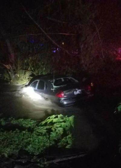 Partially submerged car following swift water rescue of five persons in Zapata City on August 21, 2016 |
|
| July to September: "La Canícula’s" Hot, Dry, Endless Summer | |
|
For a fourth summer in a row, July was largely uneventful as the upper level high pressure ridge, commonly referred to as La Canícula took control. Searing summer sunshine brought century mark temperatures to the mid/upper Valley for nearly all of the month; McAllen/Miller fell one day shy of a perfect 31 days topping 100°F. The one day break also ensured that a record string of nearly 50 straight would not occur, which did happen the last time July was this hot in 2009. With little more than passing, isolated showers/thunderstorms during the second half of the month, values ended up between 2 and 4°F above the already hot 1981-2010 averages, placing the month among the top two hottest on record, with 1998 and 2009 the only comparable July's. August somewhat followed July's lead with searing heat continuing largely unabated, and actually peaking between the 1st and 13th with afternoon temperatures ranging from the upper 90s near the coast to between 102 and 107 inland. Between the 13th and 21st, local heavy rain events helped break the overall dry period that began toward the end of June. Initial welcome rains on August 13th dropped 3 to 6 inches across thirsty ranches of the Rio Grande Plains, but a second event – a training episode of very heavy early on August 21st in Zapata that dropped at least 6 inches in some areas resulted in at least two swift water rescues, where five persons were saved from rapidly flowing water near the Medina Addition Arroyo (photo, above). The helpful rains turned a browning Upper Valley/Ranchlands green again, but the same could not be said for the Lower Valley, which escaped the rain and saw grass and brush become crispy. Temperatures continued to run hot, ranging from 1 to 3°F above the 1981-2010 average of the mid to high 80s. September 2016 broke the three year streak of wetter to much wetter than average conditions, in the month where rainfall is most welcome, and necessary, for everyone from agricultural interests to municipalities. With the exception of the Rio Grande Plains of Zapata and southwest Starr County, who once again enjoyed big rains that were 3 to 5 inches above the 3-4 inch 1981-2010 average, the remainder of the region from the Rio Grande Valley through the King Ranch saw rainfall totals of 1 to 2 inches, some 2 to 5 inches below the 5 to 6 inch average. The 25 to 50 percent of normal rainfall combined with a non-stop Canícula pattern left temperatures some 4 to 6°F above the 1981-2010 benchmark, ensuring nearly every location set a new monthly hot temperature record. In fact, it was so hot that some locations – Harlingen and McAllen in particular – broke their prior September record by more than 1°F. The 1°F difference in each case was more than the difference between the 2nd and 9th prior hottest Septembers combined! Another record shattered was at McAllen/Miller, who surged above the prior number of 100° (century mark) daily maxima (78, originally set in 1998 and repeated in 2009) in September, on the way to a grand total of 90 for the calendar year. Needless to say, Canícula "locked out" any opportunity for tropical cyclones, tropical waves – even just plain on deep Caribbean flow that provides the moisture needed for the spike of rainfall. It also brought worries from growers who recently harvested bumper crops partly based on the setup the began with soaking and flooding rains in September and October 2015. |
|
| October to December: Hot Fades to Warm; Chilly Gray 'Northers Arrive Late | |
|
October 2016 was the reverse of the wet and wild version in 2015. The last hints of La Canícula stubbornly held forth, and continue to lock out any tropical moisture while helping bring the season's first drier (humidity) days during the final week. Until then, it was "September Extended" with more searing heat and little more than passing showers and a few thunderstorms. In downtown McAllen, another five afternoons touched 100°F; combined with warm mornings (average monthly low near 71°F), the monthly average was nearly 6°F above average, another No. 1 finish. For the Valley as a whole, paltry rainfall below an inch finished well below the 2.5 to 3.5 inch average and when combined with the continued high evaporation rates despite lowering sun angle, brought areas of moderate drought and even small specks of severe drought to the Lower Valley. The three month period from July to October shattered warm/hot temperature records, again more than 1°F for the period and in some cases more than the cumulative difference between prior records that ranked #2 through #10. The close–out to 2016 was relatively quiet for a second year running, though seasonal change finally arrived in November, followed by a roller coaster between cold and warm in December that still leaned well over the warm side for longer periods than for the much shorter cold snaps. After endless summer continued through Election Day Eve (November 7), the season's first notable cool-down finally arrived on the 8th (west) and 9th (Lower Valley), and would continue through the 14th before a brief return to summer-like temperatures. The season's first drying front (November 18) followed, with welcome rainfall of more than an inch across the Lower Valley (but much less for the Upper Valley and western ranchlands) and the first morning temperatures in the 40s since mid spring. The cool was fleeting, however – temperatures more familiar to late September returned to close the month, including a searing 99° at McAllen/Miller on the 28th. The late month heat ensured another much above normal month, with temperatures some 3 to 6° above the near 70° (day/night combined) 1981-2010 average. The roller coaster of temperatures was at full run in December, not surprising given the outlook potential for winter with a weak La Niña and neutral short term teleconnections, or "puzzle pieces" that can set atmospheric patterns. Such patterns tended to lean toward a winter version of Caníula (atmospheric high pressure over northern/northwest Mexico), with occasional interruptions from surface-based shallow polar-sourced airmasses. Those interruptions, in the form of "gray 'northers", tumbled temperatures between the 8th and 9th (with readings on the 9th holding in the 40s), and the strongest crash since March 2014 dropped actual temperatures some 40 to nearly 50 degrees between December 17th and 18th. Like any roller coaster, what goes down must come up, and by Christmas and right to the end of the year, afternoon temperatures returned to the 80s. The contrasts, combined with relatively light return flow of wind, set the Valley Fog Season into motion for the second half of the month. Once again, temperatures ranged well above normal – nearly 6° in most areas, a fitting Top 10 warmest finish to what was a Number 1 finish for many areas for the Calendar Year 2016. |
|
| To Page 1 |


 Follow us on YouTube