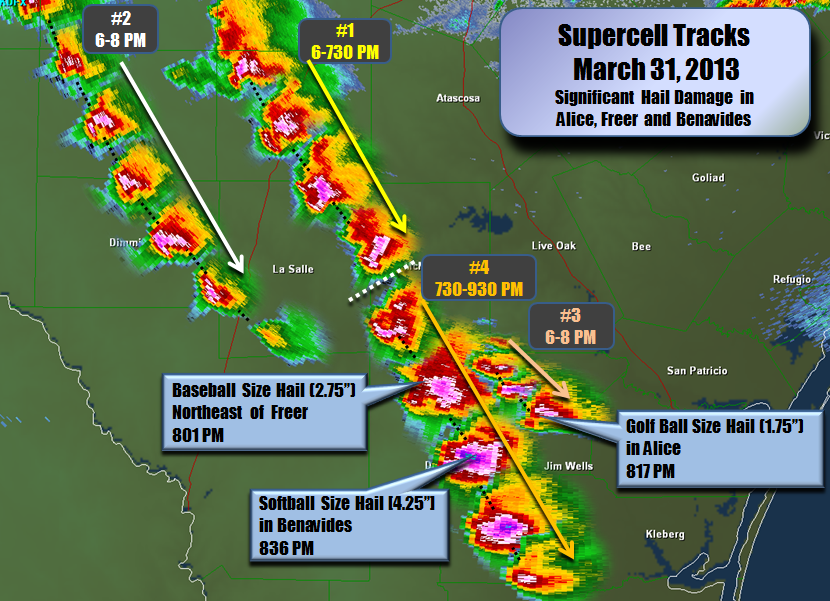
During the evening hours between 645 PM CDT and 945 PM CDT on Easter Sunday (3/31/2013), several severe thunderstorms containing very large hail developed and moved southeast across the Brush Country of South Texas. Large hail ranged in size between nickel size and softball size. The community of Benavides was the hardest hit due to softball size hail impacting this area. The hailstorm moved into Benavides from the northwest just before 830 PM CDT and exited the area around 25 minutes later. This storm reached 62 thousand feet into the atmosphere! The softball size hail in Benavides caused damage to nearly every home and business in town. Significant damage to windows, doors, roofs and siding were quite common in the northeast side of Benavides. Damage to cars in the form of broken windshields and severe dents were also common in Benavides. One person in Benavides suffered a head injury due to the softball size hail.
 |
| Benavides Hail Damage (NWS Storm Survey Photos) |
Earlier between approximately 750 PM and 810 PM CDT, the same hailstorm moved through Freer and dropped baseball size hail. Several buildings in Freer had broken windows from the baseball size hail. Also, many cars in Freer had dents reported after the storm blew through the area. Approximately ten minutes earlier, the same storm dropped baseball size hail in the community of Seven Sisters. Broken windows occurred with several buildings in Seven Sisters as a result.
Other severe thunderstorms affected communities as far north as Fowlerton and as far east as Alice. These thunderstorms produced nickel to golfball size hail. Minor damage was reported with these storms. These severe thunderstorms were triggered by an approaching upper level disturbance and the interaction between the sea breeze and a southward-moving outflow boundary (which was triggered from prior thunderstorms in the Hill Country where a cold front was located). The airmass across the Brush Country was very unstable and there was strong wind shear present. All of these factors aided in the development of large hail to develop across South Texas.


PRELIMINARY LOCAL STORM REPORT...SUMMARY
NATIONAL WEATHER SERVICE CORPUS CHRISTI TX
558 PM CDT MON APR 01 2013

..TIME...   ...EVENT...      ...CITY LOCATION...     ...LAT.LON...
..DATE...   ....MAG....      ..COUNTY LOCATION..ST.. ...SOURCE....
            ..REMARKS..

0715 PM     HAIL             FOWLERTON               28.45N 98.82W
03/31/2013  M1.75 INCH       LA SALLE           TX   CO-OP OBSERVER

            GOLF BALL SIZED HAIL. TIME ESTIMATED FROM RADAR AND COOP
            OBSERVER

0730 PM     HAIL             LOMA ALTA               28.09N 98.52W
03/31/2013  E0.88 INCH       MCMULLEN           TX   CO-OP OBSERVER

            ESTIMATED DIME AND NICKLE SIZED HAIL. TIME ESTIMATED FROM
            RADAR AND COOP OBSERVER.

0733 PM     TSTM WND GST     16 NW LOMA ALTA         28.23N 98.72W
03/31/2013  M51.00 MPH       MCMULLEN           TX   ASOS

            AT SITE KMNT.

0750 PM     HAIL             5 W SEVEN SISTERS       28.04N 98.60W
03/31/2013  E2.75 INCH       DUVAL              TX   NWS STORM SURVEY

            BROKEN WINDOWS OBSERVED TO BUILDINGS NEAR HIGHWAY 16.

0755 PM     HAIL             7 NE FREER              27.95N 98.54W
03/31/2013  E2.75 INCH       DUVAL              TX   PUBLIC

            BASEBALL SIZE HAIL BROKE WINDOWS ON RANCH HOME.

0800 PM     HAIL             6 NW LOMA ALTA          28.15N 98.59W
03/31/2013  E1.75 INCH       MCMULLEN           TX   NWS STORM SURVEY

            DENTED ROAD SIGNS FROM HAIL ALONG HIGHWAY 16.

0800 PM     HAIL             6 NNW LAKE ALICE        27.89N 98.09W
03/31/2013  M1.00 INCH       JIM WELLS          TX   PUBLIC

0801 PM     HAIL             1 NE FREER              27.89N 98.61W
03/31/2013  E2.75 INCH       DUVAL              TX   NWS STORM SURVEY

            NWS SURVEY COMBINED WITH FIRE CHIEF REPORTS INDICATES
            THAT GOLF BALL SIZED HAIL FELL IN NORTHEAST FREER CAUSING
            DENTS IN MOTOR VEHICLES...INCLUDING A NEW/USED VEHICLE
            LOT. A FEW BASEBALL SIZED HAIL STONES WERE OBSERVED AND
            BROKE A FEW WINDOWS IN NORTH FACING BUILDINGS.

0817 PM     HAIL             1 NW ALICE              27.77N 98.08W
03/31/2013  E1.75 INCH       JIM WELLS          TX   NWS STORM SURVEY

            QUARTER TO GOLFBALL SIZED HAIL REPORT IN AND JUST NORTH
            OF ALICE.

0836 PM     HAIL             BENAVIDES               27.60N 98.41W
03/31/2013  E4.25 INCH       DUVAL              TX   NWS STORM SURVEY

            *** 1 INJ *** NWS STORM SURVEY CONCLUDED THAT BASEBALL TO
            SOFTBALL SIZED FELL ACROSS BENAVIDES CAUSING DAMAGE TO
            NEARLY EVERY HOME AND BUSINESS IN THE TOWN. DAMAGE
            INCLUDED BROKEN WINDOWS...DOORS...ROOFS AND SIDING AND
            WAS CONFINED PRIMARILY TO THE NORTH AND EAST SIDE OF
            STRUCTURES. VEHICLES WERE ALSO SEVERELY DENTED WITH LARGE
            HOLES IN WINDSHIELDS OR COMPLETELY BROKEN OUT. ONE PERSON
            SUFFERED A HEAD INJURY.

0836 PM     HAIL             2 W BENAVIDES           27.60N 98.44W
03/31/2013  E4.00 INCH       DUVAL              TX   TRAINED SPOTTER

            HAIL BUSTED WINDOWS OF VEHICLES AND DESTROYED SOLAR
            PANELS.

0910 PM     HAIL             3 SE CONCEPCION         27.35N 98.23W
03/31/2013  E0.50 INCH       JIM WELLS          TX   PUBLIC


 Follow us on YouTube