March 19, 2018 Tornadoes and Severe Weather:
Overview:
Severe thunderstorms affected portions of north and central Georgia from the evening of March 19th into the early morning hours of March 20th. A warm front was draped across north Georgia as a low pressure system passed to the north of the state. As an upper disturbance moved into the region, supercell thunderstorms developed across northern Alabama and pushed into Georgia by late evening. With strong wind shear in place, rotating thunderstorms produced tornadoes, hail, and wind damage across Alabama and Georgia. In Georgia, three tornadoes were confirmed. Two EF-1 tornadoes affected Haralson County, and one EF-2 tornado caused substantial damage in a south Fulton County neighborhood. The first EF-1 tornado in Haralson County was a continuation of a long-track tornado from eastern Alabama. Additional hail and wind reports were scattered across the area.
|
|
 |
|
|
Surface Map (3/19, 11 PM) The surface analysis shows a warm front draped across north Georgia ahead of an approaching surface low. |
500 mb analysis (3/19, 11 PM) An upper trough helped spark thunderstorm development. |
|
|
 |
|
|
MUCAPE (3/19, 11 PM) Moderate instability was in place behind the warm front across much of the state. |
0-3 Helicity (3/19, 11 PM) High helicity values favored rotating supercells. |
|
|
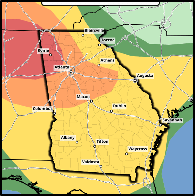
| The Storm Prediction Center outlook on March 19th highlighted a Moderate (Red) and Enhanced (Orange) Risk for severe weather across much of north Georgia with a Slight (Yellow) Risk for the remainder of the state. |
|
|
|
|
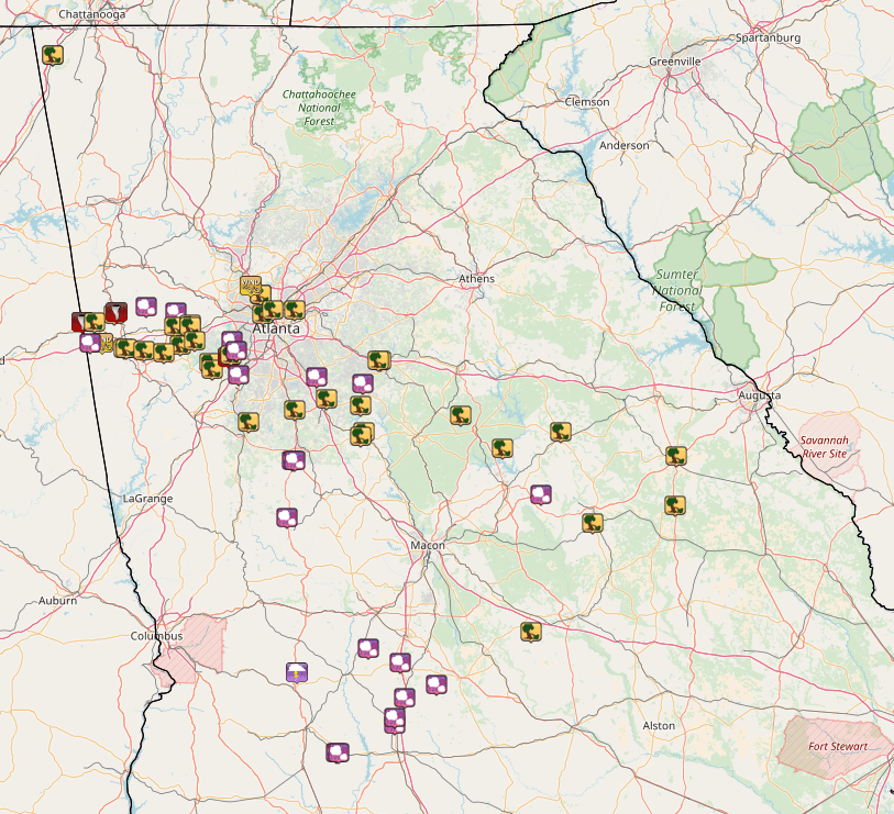
A number of severe thunderstorm (yellow) and tornado warnings (red) were issued as severe thunderstorms swept through Georgia. |
A significant number of wind, hail, and tornado damage reports were received on the evening of March 19th into early morning of March 20th. |
|
|
| Severe thunderstorms entered western Georgia from Alabama late on the evening of March 19th. |
Haralson County Tornado #1:
Note: This tornado is a continued track of the tornado that affected Jacksonville, AL earlier on the evening of March 19th. The following information details only the Georgia portion of the tornado damage survey. For the Alabama portion of the track, please refer to the page from NWS Birmingham.
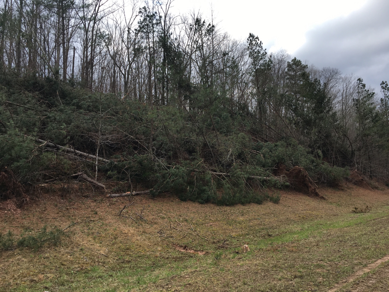
This tornado moved into Georgia at 10:14 PM EDT along Broad Street where several trees were snapped or uprooted along the road. One large oak tree fell onto a home 1/4 of a mile from the state line, causing extensive damage to the structure. Other snapped and fallen trees in this area accounted for the highest wind speed estimate of 95 mph for this tornado, an EF-1 rating (for the Georgia portion of the track). The tornado then quickly dissipated after a surge within the rear-flank downdraft caused the storm to occlude. The last observed damage caused by this tornado was along Edger Lane Circle between Broad Street and Womack Road.
After the tornado dissipated, extensive damage to hundreds of trees was observed along Broad Street and Highway 120 (among other locations in the area). This damage was caused by two strong downbursts within the rear-flank downdraft as the supercell occluded and not by the aforementioned tornado.
|
|
|
|
 |
| This mobile home was heavily damaged b a large falling tree. | Falling trees caused significant damage to this home. |
|
|
 |
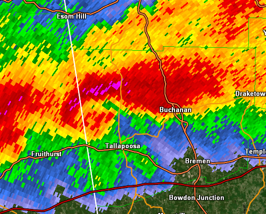
| Reflectivity (10:14 PM EDT) | Velocity (10:14 PM EDT) |
A short-lived, though impactful, tornado caused damage on the western side of Buchanan on the evening of March 19th. The tornado formed on the backside of an occluding, cyclic supercell which had a history of producing strong tornadoes in Alabama. After moving into Georgia, multiple downbursts within the rear-flank downdraft caused extensive straight-line wind damage, primarily along Broad Street and Highway 120. As the supercell began to occlude, a tornado formed on the northern side of Buchanan and took a southerly, cyclonically-curved track for approximately 1.4 miles.
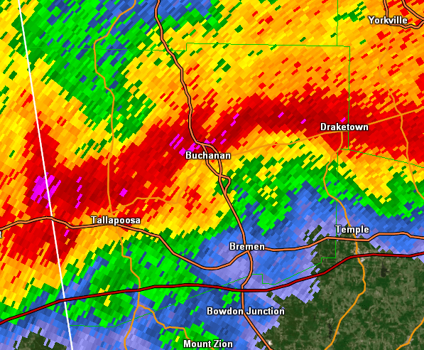
The tornado touched down near the New Vision Church Cemetery at 10:25 PM, snapping or uprooting small trees at it traveled south-southwest. Around 10:26 PM, the tornado grew in size to approximately 500 yards as it crossed Highway 120 just west of Business Highway 24. At this point several very large trees were snapped or uprooted. 90 mph wind speeds were estimated based on the damage observed, making the tornado a low-end EF-1. Just south of Highway 120 on Tallapoosa Street, a large tree fell onto a home, seriously injuring two people inside. The tornado then continued south-southeast, snapping or uprooting several more small trees before dissipating at around 10:27 PM just west of Business Highway 24 between Jeffers Street and Macedonia Church Road.
|
|
|
|
 |
| A huge tree crashed into this home, causing injuries to two residents inside. | Large uprooted trees such as this one were common around the Buchanan area. |
|
|
 |
| Reflectivity (10:26 PM EDT) | Velocity (10:26 PM EDT) |
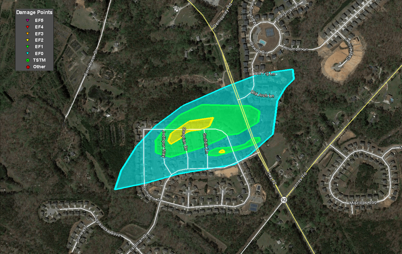
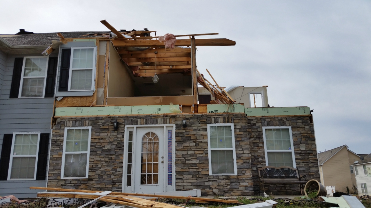
A very brief, but strong, tornado touched down in the city of South Fulton between Fairburn and Campbellton late on the evening of March 19th. Much of the damage was to two-story residential homes in the Chestnut Ridge neighborhood. More than 50 homes sustained some degree of visible damage with at least half of those homes receiving significant damage. The worst of the damage occurred along Jumpers Trail between Jodhpur Road and Suffolk Lane. In this small area, numerous homes had large sections of the roof removed along with large piece of the exterior walls (mainly on one or two sides). Based on this consistent structural damage, the tornado earned its EF-2 rating with maximum winds estimated around 120 mph. Large trees running along the north and east areas of the neighborhood were also snapped or uprooted.
As quickly as the tornado developed it dissipated as the supercell tracked eastward across Highway 92 just north of Jones Road. East of Highway 92 in a separate neighborhood, one home lost part of its rood, and several homes along Winstar Lane lost shingles or small pieces of siding. Just past this location, no further damage was observed. The tornado end point was around 1/2 mile from the start location.
|
|
|
|
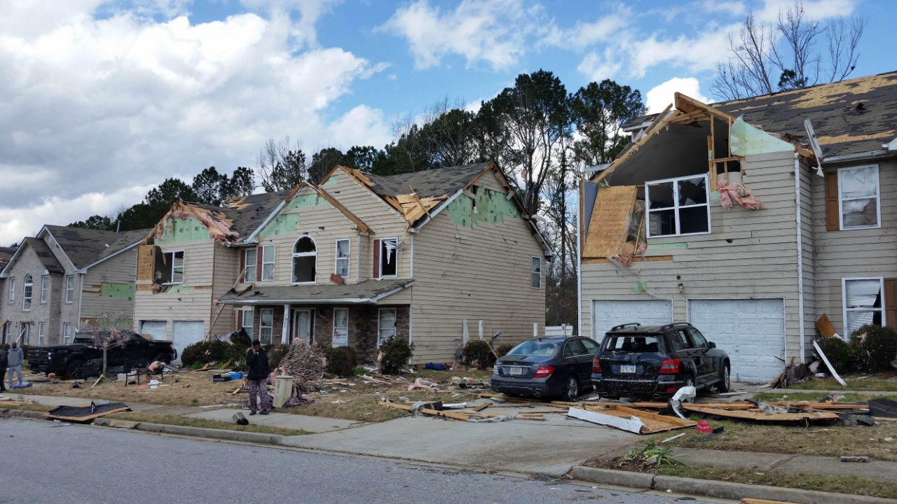 |
| These homes along Jumpers Trail sustained significant structural damage. | Sections of roof and exterior walls were removed from these homes. |
|
|
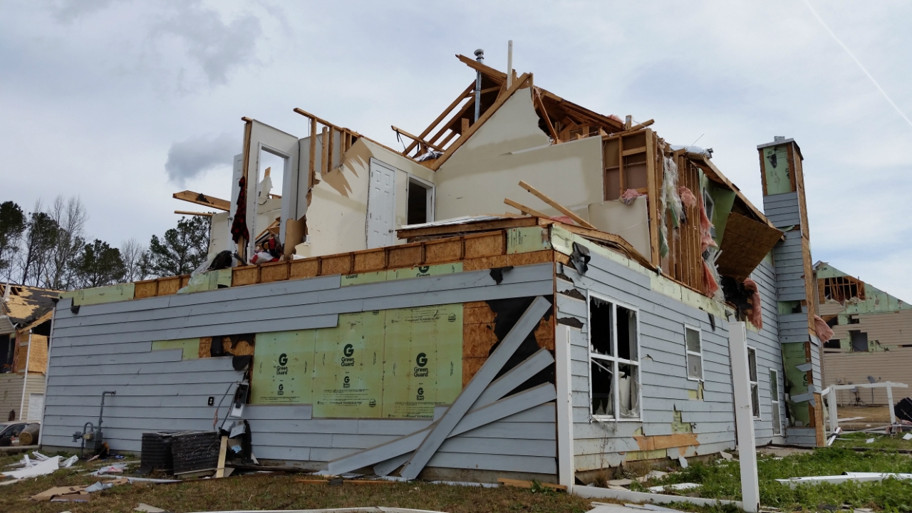 |
| The large portions of roof and exterior walls removed from this home was indicative of EF-2 damage. | Here is another view of the significant damage caused to this home in the Chestnut Ridge neighborhood. |
|
|
 |
| Reflectivity (11:12 PM EDT) | Velocity (11:12 PM EDT) |
| Haralson County Damaging Wind #1: | |
| Estimated Peak Wind: | 90-95 mph |
| Swath Length: | Approx. 8 miles |
| Swath Width: | 1.75 miles |
| Fatalities: | 0 |
| Injuries: | 0 |
| Start Date: | March 19, 2018 |
| Start Time: | 10:14 PM EDT |
| Start Location: | 4.3 miles NW of Tallapoosa |
| Start Lat/Lon: | 33.7654 / -85.3597 |
| End Date: | March 19, 2018 |
| End Time: | 10:22 PM EDT |
| End Location: | 2.75 miles SW of Buchanan |
| End Lat/Lon: | 33.7646 / -85.2089 |
|
|
 |
| Numerous trees were downed along this roadway. | Numerous large trees were downed across the area affected by the damaging winds. |
| Haralson County Damaging Wind #1: | |
| Estimated Peak Wind: | 80-85 mph |
| Swath Length: | 2.75 miles |
| Swath Width: | 650 yards |
| Fatalities: | 0 |
| Injuries: | 0 |
| Start Date: | March 19, 2018 |
| Start Time: | 10:32 PM EDT |
| Start Location: | 2.0 miles north of Buchanan |
| Start Lat/Lon: | 33.8222 / -85.2129 |
| End Date: | March 19, 2018 |
| End Time: | 10:35 PM EDT |
| End Location: | 1.5 miles east of Buchanan |
| End Lat/Lon: | 33.8062 / -85.2128 |
|
|
 |
| Numerous trees were downed alongside Highway 27. | Numerous trees were downed alongside Highway 27. |


 Follow us on YouTube