Overview
|
A QLCS (Quasi-linear Convective System) moved across Middle Tennessee during the early morning hours of May 4, 2021. This line of thunderstorms spawned a total of 14 EF-0 tornadoes throughout Middle Tennessee, at least 4 of which were captured on video by local residents. In addition to the tornadoes, significant straight-line wind damage also affected many other areas of Middle Tennessee, and was just as damaging as the tornadoes in many cases. Thankfully, no injuries or deaths were reported. Special thanks goes to Middle Tennessee emergency management, tSpotter coordinators, and the public for their assistance and helpful information with these difficult and lengthy storm surveys.
|
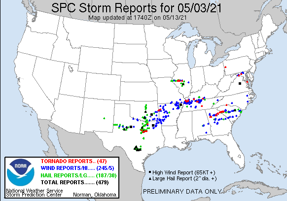 May 3-May 4 (before 7 AM), 2021 SPC Storm Reports |
|
Interactive Tornado Map Tornadoes |
||||||||||||||||||||||||||||||||||||||||||||||||||||||||||||||||||||||||||||||||||||||||||||||||||||||||||||||||||||||||||||||||||||||||||||||||||||||||||||||||||||||||||||||||||||||||||||||||||||||||||||||||||||||||||||||||
|
Tornado #1 - Joelton, TN
Tornado #4 - Orlinda, TN
Tornado #7 - Gallatin, TN
Tornado #10 - East Trousdale, TN
Tornado #12 - Alexandria, TN
Tornado #2 - North of Springfield, TN
Tornado #8 - Castalian Springs, TN
Tornado #13 - Smithville, TN
Tornado #3 - Greenbriar, TN
Tornado #6 - White House, TN
Tornado #9 - West Trousdale, TN
Tornado #14 - North Sparta, TN
|
||||||||||||||||||||||||||||||||||||||||||||||||||||||||||||||||||||||||||||||||||||||||||||||||||||||||||||||||||||||||||||||||||||||||||||||||||||||||||||||||||||||||||||||||||||||||||||||||||||||||||||||||||||||||||||||||
The Enhanced Fujita (EF) Scale classifies tornadoes into the following categories:
| EF0 Weak 65-85 mph |
EF1 Moderate 86-110 mph |
EF2 Significant 111-135 mph |
EF3 Severe 136-165 mph |
EF4 Extreme 166-200 mph |
EF5 Catastrophic 200+ mph |
 |
|||||
Damage Surveys
Public Information Statement
National Weather Service Nashville TN
416 PM CDT Fri May 14 2021

...Updated NWS Damage Surveys for May 4, 2021 Tornado Event...

.Summary...

A total of 14 EF-0 tornadoes have now been determined to have
touched down from the early morning severe weather event of May
4, 2021. At least 4 of these tornadoes were captured on video by
local residents. In addition to the tornadoes, significant
straight-line wind damage also affected many other areas of
Middle Tennessee, and was just as damaging as the tornadoes in
many cases. Thankfully, no injuries or deaths have been reported.

As of today, the 2021 yearly total of tornadoes across Middle
Tennessee has reached 20, with three tornadoes occurring in
March, one in April, and sixteen in May.

Special thanks goes to Middle Tennessee emergency management,
tSpotter coordinators, and the public for their assistance and
helpful information with these difficult and lengthy storm
surveys.


.Joelton Tornado...

Rating:                 EF0
Estimated Peak Wind:    80 mph
Path Length /statute/:  4.90 miles
Path Width /maximum/:   100.0 yards
Fatalities:             0
Injuries:               0

Start Date:             05/04/2021
Start Time:             05:54 AM CDT
Start Location:         8 SW Greenbrier / Cheatham County / TN
Start Lat/Lon:          36.3537 / -86.92

End Date:               05/04/2021
End Time:               06:00 AM CDT
End Location:           4 SW Ridgetop / Davidson County / TN
End Lat/Lon:            36.3474 / -86.8324

Survey Summary:
An EF-0 tornado touched down near Cotton Harris Road along the
Cheatham/Davidson county line and moved eastward across northern
portions of Joelton, blowing down dozens of trees and large tree
limbs on Harper Road, Baxter Road, Wilkinson Road and Strawberry
Hill Road. The tornado lifted east of Ridgewood Road.


.North Robertson Tornado...

Rating:                 EF0
Estimated Peak Wind:    75 mph
Path Length /statute/:  1.76 miles
Path Width /maximum/:   25.0 yards
Fatalities:             0
Injuries:               0

Start Date:             05/04/2021
Start Time:             05:56 AM CDT
Start Location:         5 NNE Springfield / Robertson County / TN
Start Lat/Lon:          36.5621 / -86.8271

End Date:               05/04/2021
End Time:               05:58 AM CDT
End Location:           6 NE Springfield / Robertson County / TN
End Lat/Lon:            36.5627 / -86.7961

Survey Summary:
This small EF-0 tornado touched down north of Lakeview Road and
moved eastward across Calvert Road, heavily damaging an
outbuilding, blowing much of the roof off a large barn, and
knocking down several trees. More trees were blown down and a
carport was destroyed on Hancock Road before the tornado lifted
near Charles Dorris Road.


.Greenbrier Tornado...

Rating:                 EF0
Estimated Peak Wind:    75 mph
Path Length /statute/:  2.21 miles
Path Width /maximum/:   200.0 yards
Fatalities:             0
Injuries:               0

Start Date:             05/04/2021
Start Time:             06:01 AM CDT
Start Location:         3 NNE Greenbrier / Robertson County / TN
Start Lat/Lon:          36.4675 / -86.7798

End Date:               05/04/2021
End Time:               06:04 AM CDT
End Location:           4 W White House / Robertson County / TN
End Lat/Lon:            36.472 / -86.742

Survey Summary:
An EF-0 tornado touched down north of Morton Road to the
northeast
of Greenbrier and moved eastward. Numerous trees were blown down,
an outdoor shed was destroyed, and a home on Distillery Road
suffered minor damage. More trees were blown down on Gideon Road
with at least two homes damaged by falling trees. Additional
trees
were blown down along Herbert Shannon Road before the tornado
lifted near Highway 76.

South of the tornado track, a 1/4 mile swath of straight-line
wind damage also blew down several trees on Morton Road and
Gideon
Road.


.Orlinda Tornado...

Rating:                 EF0
Estimated Peak Wind:    80 mph
Path Length /statute/:  9.40 miles
Path Width /maximum/:   50.0 yards
Fatalities:             0
Injuries:               0

Start Date:             05/04/2021
Start Time:             06:02 AM CDT
Start Location:         5 WNW Cross Plains / Robertson County /
TN
Start Lat/Lon:          36.5732 / -86.7618

End Date:               05/04/2021
End Time:               06:14 AM CDT
End Location:           4 SSW Black Jack / Sumner County / TN
End Lat/Lon:            36.5781 / -86.5951

Survey Summary:
This EF-0 tornado began along Henry Road southwest of Orlinda
where it blew down several trees. Moving eastward, the tornado
snapped and uprooted numerous trees along Doss Road with one tree
falling onto a home. Two outbuildings were destroyed on Dixon
Road, and tree limbs were knocked down just south of East
Robertson Elementary School. Numerous additional trees were
blown down on Pleasant Hill Road and a shed was blown into the
roadway and destroyed. Further to the east, a barn was damaged on
Starks Road, and more trees were uprooted on Rock House Road and
Highway 31W. The tornado dissipated into a large microburst that
blew down several trees in neighborhoods along West Harper Road
and Jernigan Road, with both roadways blocked.


.Goodlettsville Tornado...

Rating:                 EF0
Estimated Peak Wind:    80 mph
Path Length /statute/:  6.37 miles
Path Width /maximum/:   200.0 yards
Fatalities:             0
Injuries:               0

Start Date:             05/04/2021
Start Time:             06:03 AM CDT
Start Location:         3 SSW Ridgetop / Davidson County / TN
Start Lat/Lon:          36.348 / -86.7939

End Date:               05/04/2021
End Time:               06:12 AM CDT
End Location:           2 SE Millersville / Sumner County / TN
End Lat/Lon:            36.358 / -86.6808

Survey Summary:
An EF-0 tornado touched down along Greer Road northwest of
Goodlettsville and moved eastward, blowing down dozens of trees,
power lines and some power poles as it moved across Lakeside
Drive, Freeman Hollow Road, Lickton Pike, Old Springfield Road,
and Highway 41. More trees were blown down on the east side of
Goodlettsville on Patton Branch Road and Madison Creek Road
before the tornado lifted.


.White House Tornado...

Rating:                 EF0
Estimated Peak Wind:    65 mph
Path Length /statute/:  0.71 miles
Path Width /maximum/:   25.0 yards
Fatalities:             0
Injuries:               0

Start Date:             05/04/2021
Start Time:             06:10 AM CDT
Start Location:         1 NE White House / Robertson County / TN
Start Lat/Lon:          36.4684 / -86.6593

End Date:               05/04/2021
End Time:               06:11 AM CDT
End Location:           1 ENE White House / Sumner County / TN
End Lat/Lon:            36.4705 / -86.6468

Survey Summary:
A small, brief and weak EF-0 tornado touched down in White House
along Highway 76 just west of Highway 31W, then moved northeast
across the Highway 31W and Portland Road intersection area before
lifting near Reidway Drive. A few trees were knocked down west of
Highway 31W and the sheet metal roof was blown off a building.
Part of the metal roof was also blown off a variety store on
Portland Road and a few more trees were knocked down before the
tornado lifted. A resident captured the small tornado on video as
he drove south on Highway 31.

South of the tornado track, a 1/2 to 3/4 mile wide swath of
straight-line wind damage affected neighborhoods from Raymond
Hirsch Parkway eastward across Tyree Springs Road, Palmers Chapel
Road, Christiana Drive, Fern Valley Road, and Shun Pike.
Scattered trees were blown down in this area and a few homes
suffered minor roof damage.


.Gallatin Tornado...

Rating:                 EF0
Estimated Peak Wind:    85 mph
Path Length /statute/:  3.88 miles
Path Width /maximum/:   0.0 yards
Fatalities:             0
Injuries:               0

Start Date:             05/04/2021
Start Time:             06:21 AM CDT
Start Location:         5 NNE Hendersonville / Sumner County / TN
Start Lat/Lon:          36.3542 / -86.5601

End Date:               05/04/2021
End Time:               06:25 AM CDT
End Location:           3 SW Gallatin / Sumner County / TN
End Lat/Lon:            36.3604 / -86.4954

Survey Summary:
This EF-0 tornado touched down along Saundersville Road north of
Country Hills Golf Course, snapping power poles and uprooting
trees. The tornado continued to intermittently touch down as it
moved eastward, and was captured on video along Big Station Camp
Blvd near Springdale Lane. Several trees were blown down along
Vietnam Veterans Blvd, and two large barns were completely
destroyed on St Blaise Road. The tornado weakened quickly as it
passed through the west side of the Vol State College Campus and
a Publix Supermarket parking lot on Highway 31E, blowing down a
few trees and signs before lifting.


.Castalian Springs Tornado...

Rating:                 EF0
Estimated Peak Wind:    75 mph
Path Length /statute/:  6.86 miles
Path Width /maximum/:   0.0 yards
Fatalities:             0
Injuries:               0

Start Date:             05/04/2021
Start Time:             06:31 AM CDT
Start Location:         2 ESE Gallatin / Sumner County / TN
Start Lat/Lon:          36.3567 / -86.4174

End Date:               05/04/2021
End Time:               06:39 AM CDT
End Location:           7 WSW Hartsville / Sumner County / TN
End Lat/Lon:            36.3697 / -86.298

Survey Summary:
This EF-0 tornado began on the southeast side of Gallatin near
Coles Ferry Road and moved eastward, blowing down numerous trees
on Steam Plant Road, Newton Lane, Hidden Cove Road, Cairo Road,
and Lakeview Road. Trees continued to be blown down as the
tornado passed south of Castalian Springs on East Robertson Road,
Harsh Lane, Macedonia Road, and Corum Hill Road before the
tornado dissipated.


.West Trousdale Tornado...

Rating:                 EF0
Estimated Peak Wind:    80 mph
Path Length /statute/:  5.05 miles
Path Width /maximum/:   200.0 yards
Fatalities:             0
Injuries:               0

Start Date:             05/04/2021
Start Time:             06:38 AM CDT
Start Location:         8 ENE Gallatin / Sumner County / TN
Start Lat/Lon:          36.4226 / -86.3137

End Date:               05/04/2021
End Time:               06:44 AM CDT
End Location:           4 W Hartsville / Trousdale County / TN
End Lat/Lon:            36.403 / -86.228

Survey Summary:
An EF-0 tornado touched down along Rock Springs Road south of
Chenault Lane, heavily damaging a barn and blowing down numerous
trees. The tornado then moved east across Lauderdale Lane and
Homer Scott Road, continuing to blow down trees. Turning more
southeast and entering Trousdale County, the tornado damaged
several homes and blew down dozens of trees along Highway 231,
Templow Road, Bass Road, Walnut Grove Road, and Gore Lane. The
tornado dissipated into a large downburst that caused widespread
straight-line wind damage along Highway 25 as well as in and
around the city of Hartsville.


.East Trousdale Tornado...

Rating:                 EF0
Estimated Peak Wind:    75 mph
Path Length /statute/:  3.27 miles
Path Width /maximum/:   0.0 yards
Fatalities:             0
Injuries:               0

Start Date:             05/04/2021
Start Time:             06:54 AM CDT
Start Location:         2 ENE Hartsville / Trousdale County / TN
Start Lat/Lon:          36.3945 / -86.1153

End Date:               05/04/2021
End Time:               06:58 AM CDT
End Location:           5 E Hartsville / Trousdale County / TN
End Lat/Lon:            36.3797 / -86.0613

Survey Summary:
An EF-0 tornado touched down just west of the Cato community and
moved southeast, damaging a business at Highway 10 and Fort
Blount Road. The tornado continued through rural areas blowing
down trees along Glasgow Branch Road and Lick Creek Road before
lifting.


.Lafayette Tornado...

Rating:                 EF0
Estimated Peak Wind:    65 mph
Path Length /statute/:  1.93 miles
Path Width /maximum/:   25.0 yards
Fatalities:             0
Injuries:               0

Start Date:             05/04/2021
Start Time:             06:56 AM CDT
Start Location:         1 WNW Lafayette / Macon County / TN
Start Lat/Lon:          36.5314 / -86.0504

End Date:               05/04/2021
End Time:               06:58 AM CDT
End Location:           1 SSE Lafayette / Macon County / TN
End Lat/Lon:            36.5097 / -86.0288

Survey Summary:
This small, weak tornado touched down on Brattowntown Circle on
the west side of Lafayette and moved southeast, knocking down
several trees and partially blowing the roof off a convenience
store on Highway 52. Lafayette EMS personnel captured the tornado
on video as it passed south of their station at Hartsville Road
and Highway 52. The tornado is estimated to have lifted near Hunt
Lane.


.Alexandria Tornado...

Rating:                 EF0
Estimated Peak Wind:    75 mph
Path Length /statute/:  1.03 miles
Path Width /maximum/:   25.0 yards
Fatalities:             0
Injuries:               0

Start Date:             05/04/2021
Start Time:             07:20 AM CDT
Start Location:         1 S Alexandria / De Kalb County / TN
Start Lat/Lon:          36.0571 / -86.0347

End Date:               05/04/2021
End Time:               07:21 AM CDT
End Location:           2 SE Alexandria / De Kalb County / TN
End Lat/Lon:            36.058 / -86.0161

Survey Summary:
This small, brief tornado touched down on the south side of
Alexandria. Security video cameras at a home on Old Liberty Road
captured the tornado as the roof and back porch were blown off
the house. The tornado is estimated to have lifted east of
Nashville Highway.


.Smithville Tornado...

Rating:                 EF0
Estimated Peak Wind:    75 mph
Path Length /statute/:  2.92 miles
Path Width /maximum/:   100.0 yards
Fatalities:             0
Injuries:               0

Start Date:             05/04/2021
Start Time:             07:43 AM CDT
Start Location:         3 NNE Smithville / De Kalb County / TN
Start Lat/Lon:          36.0021 / -85.8028

End Date:               05/04/2021
End Time:               07:47 AM CDT
End Location:           4 ENE Smithville / De Kalb County / TN
End Lat/Lon:            35.9837 / -85.7564

Survey Summary:
This EF-0 tornado touched down along Coconut Ridge Road north of
Smithville, blowing down several trees. Moving southeast, the
tornado crossed Highway 56 and moved down Holiday Haven Road,
damaging several homes and barns and continuing to blow down
trees. The tornado appeared to lift near Ashburn Road.


.North Sparta Tornado...

Rating:                 EF0
Estimated Peak Wind:    80 mph
Path Length /statute/:  1.11 miles
Path Width /maximum/:   50.0 yards
Fatalities:             0
Injuries:               0

Start Date:             05/04/2021
Start Time:             08:07 AM CDT
Start Location:         3 NNW Sparta / White County / TN
Start Lat/Lon:          35.9738 / -85.4938

End Date:               05/04/2021
End Time:               08:09 AM CDT
End Location:           2 NNW Sparta / White County / TN
End Lat/Lon:            35.9635 / -85.4786

Survey Summary:
This small EF-0 tornado touched down on the north side of Sparta
near Franklin Avenue and Spring Street, Moving southeast, the
tornado heavily damaged a barn on Roberts Matthews Highway and
blew down several trees at the Sparta Drive-In Theatre. More
trees were blown down on Edgewood Drive before the tornado
lifted.

On the west side of Sparta along Old Smithville Highway and
Highway 70, straight-line winds caused significant damage to
trees, outbuildings, and some homes.


&&

EF Scale: The Enhanced Fujita Scale classifies tornadoes into the
following categories:

EF0...Weak......65 to 85 mph
EF1...Weak......86 to 110 mph
EF2...Strong....111 to 135 mph
EF3...Strong....136 to 165 mph
EF4...Violent...166 to 200 mph
EF5...Violent...>200 mph

NOTE:
The information in this statement is preliminary and subject to
change pending final review of the events and publication in NWS
Storm Data.


$$

10
Radar
| Radar loop from May 4, 2021 |
Storm Reports
PRELIMINARY LOCAL STORM REPORT...SUMMARY
NATIONAL WEATHER SERVICE NASHVILLE TN
656 AM CDT THU MAY 06 2021

..TIME...   ...EVENT...      ...CITY LOCATION...     ...LAT.LON...
..DATE...   ....MAG....      ..COUNTY LOCATION..ST.. ...SOURCE....
            ..REMARKS..

0900 AM     FLASH FLOOD      SPRING HILL             35.74N  86.92W
05/03/2021                   MAURY              TN   SOCIAL MEDIA

            FLOODING ON KEDRON ROAD IN SPRING HILL. SEVERAL REPORTS
            OF ROADS FLOODED AND CLOSED ACROSS WILLIAMSON COUNTY.

1142 AM     TORNADO          6 NNW MANCHESTER        35.55N  86.13W
05/03/2021                   COFFEE             TN   EMERGENCY MNGR

            A BRIEF EF-0 TORNADO TOUCHED DOWN ALONG BOYNTON VALLEY
            ROAD IN THE FREDONIA COMMUNITY AND MOVED NORTHEAST,
            BLOWING DOWN NUMEROUS TREES IN A STRONGLY CONVERGENT
            PATTERN AND CAUSING MINOR DAMAGE TO 2 HOMES. THE TORNADO
            PATH WAS CLEARLY VISIBLE IN A NEARBY CORN FIELD.
            ADDITIONAL TREES WERE BLOWN DOWN ACROSS FREDONIA ROAD
            THAT BLOCKED THE ROADWAY BEFORE THE TORNADO LIFTED. MANY
            RESIDENTS WITNESSED AND TOOK PHOTOS OF THE TORNADO.

0155 AM     HAIL             8 E CELINA              36.53N  85.36W
05/04/2021  E1.00 INCH       CLAY               TN   TRAINED SPOTTER

0318 AM     HAIL             7 SE CELINA             36.49N  85.41W
05/04/2021  E0.88 INCH       OVERTON            TN   SOCIAL MEDIA

            FACEBOOK REPORT OF NICKEL SIZE HAIL IN TIMOTHY, TN.

0447 AM     TSTM WND DMG     DOVER                   36.48N  87.84W
05/04/2021                   STEWART            TN   EMERGENCY MNGR

            NUMEROUS TREES DOWN AND POWER OUTAGES ACROSS STEWART
            COUNTY

0530 AM     TSTM WND DMG     11 SE CLARKSVILLE       36.45N  87.21W
05/04/2021                   MONTGOMERY         TN   SOCIAL MEDIA

            SEVERAL TREES WERE BLOWN DOWN AT 3567 TANNAHILL COURT

0543 AM     TSTM WND DMG     CEDAR HILL              36.55N  87.00W
05/04/2021                   ROBERTSON          TN   SOCIAL MEDIA

            NUMEROUS TREES DOWN AND POWER OUTAGES ACROSS ROBERTSON
            COUNTY

0552 AM     TORNADO          4 NW JOELTON            36.35N  86.92W
05/04/2021                   CHEATHAM           TN   EMERGENCY MNGR

            AN EF-0 TORNADO TOUCHED DOWN NEAR COTTON HARRIS ROAD
            ALONG THE CHEATHAM/DAVIDSON COUNTY LINE AND MOVED
            EASTWARD ACROSS NORTHERN PORTIONS OF JOELTON BLOWING
            DOWN SCATTERED TREES AND LARGE TREE LIMBS ON HARPER
            ROAD...BAXTER ROAD...WILKINSON ROAD AND STRAWBERRY HILL
            ROAD. THE TORNADO LIFTED EAST OF RIDGEWOOD ROAD.

0605 AM     TORNADO          3 S RIDGETOP            36.35N  86.77W
05/04/2021                   DAVIDSON           TN   NWS STORM SURVEY

            AN EF-0 TORNADO TOUCHED DOWN AROUND MCMAHAN ROAD
            NORTHWEST OF GOODLETTSVILLE AND MOVED EASTWARD, BLOWING
            DOWN DOZENS OF TREES AS IT MOVED ACROSS LAKESIDE DRIVE,
            FREEMAN HOLLOW ROAD, LICKTON PIKE, AND OLD SPRINGFIELD
            ROAD. SEVERAL TREES WERE BLOWN DOWN AND POWER POLES WERE
            SNAPPED ON HIGHWAY 41 BETWEEN WILLIAMSON ROAD AND
            HIGHWAY 31. MORE TREES WERE BLOWN DOWN ON THE NORTHEAST
            SIDE OF GOODLETTSVILLE ON PATTON BRANCH ROAD AND MADISON
            CREEK ROAD BEFORE THE TORNADO LIFTED.

0607 AM     TSTM WND DMG     GOODLETTSVILLE          36.32N  86.71W
05/04/2021                   DAVIDSON           TN   SOCIAL MEDIA

            TSPOTTER REPORT OF A TREE THROUGH A FENCE IN
            GOODLETTSVILLE OFF OF LICKTON PIKE.

0608 AM     TSTM WND DMG     1 W MILLERSVILLE        36.38N  86.73W
05/04/2021                   SUMNER             TN   SOCIAL MEDIA

            4" TREE SNAPPED MID TRUNK ON WILLIAMSON RD NEAR MANSKER
            CREEK

0609 AM     TSTM WND DMG     MILLERSVILLE            36.38N  86.70W
05/04/2021                   SUMNER             TN   SOCIAL MEDIA

            POWER POLES SNAPPED IN HALF ALONG WITH 12 TO 18 INCH
            TREES SNAPPED ALONG 41 BETWEEN 31W SPLIT AND WILLAMSON.
            LINES DOWN AND TREES DOWN.

0612 AM     TSTM WND DMG     GOODLETTSVILLE          36.32N  86.71W
05/04/2021                   DAVIDSON           TN   TRAINED SPOTTER

            TREES DOWN ALONG MADISON CREEK RD

0620 AM     TSTM WND DMG     PORTLAND                36.59N  86.52W
05/04/2021                   SUMNER             TN   PUBLIC

            NUMEROUS UPROOTED TREES ALONG AUSTIN BRIDGE RD AND
            RIGGS RD

0625 AM     TSTM WND DMG     HAMPSHIRE               35.60N  87.29W
05/04/2021                   MAURY              TN   EMERGENCY MNGR

            A COUPLE OF POWER POLES BLOWN DOWN NEAR HAMPSHIRE

0627 AM     TSTM WND DMG     SW WHITE HOUSE          36.46N  86.67W
05/04/2021                   ROBERTSON          TN   EMERGENCY MNGR

            REPORT OF NUMEROUS TREES DOWN IN ROBERTSON COUNTY.

0629 AM     TSTM WND DMG     GALLATIN                36.38N  86.45W
05/04/2021                   SUMNER             TN   SOCIAL MEDIA

            TREES DOWN IN PORTIONS OF GALLATIN

0630 AM     TSTM WND DMG     2 NW SUMMERTOWN         35.45N  87.34W
05/04/2021                   LAWRENCE           TN   EMERGENCY MNGR

            ROOF DAMAGED ON MOBILE HOME AT 348 HIGHWAY 20 AND TREES
            DOWN IN AREA

0632 AM     TSTM WND DMG     1 E HERMITAGE           36.20N  86.60W
05/04/2021                   DAVIDSON           TN   TRAINED SPOTTER

            REPORT OF TREE AND LIMBS DOWN IN TULIP GROVE
            NEIGHBORHOOD.

0639 AM     TSTM WND DMG     3 ENE CASTALIAN SPRINGS 36.42N  86.27W
05/04/2021                   TROUSDALE          TN   SOCIAL MEDIA

            REPORT OF SEVERAL TREES DOWN. FRONT PORCH OVERHANG
            COLLAPSED ALONG WITH COLUMNS

0653 AM     TSTM WND DMG     LAFAYETTE               36.52N  86.03W
05/04/2021                   MACON              TN   SOCIAL MEDIA

            TREES AND POWERLINES DOWN...SOME ROOFS DAMAGED AS WELL

0655 AM     TSTM WND DMG     HARTSVILLE              36.39N  86.16W
05/04/2021                   TROUSDALE          TN   EMERGENCY MNGR

            MULTIPLE TREES AND POWERLINES DOWN...SOME RESIDENTIAL
            DAMAGE ON 231N...DAMAGE TO BARN ON DAVENPORT
            LANE...MULTIPLE ROADS BLOCKED

0655 AM     TSTM WND DMG     4 SW LEBANON            36.17N  86.37W
05/04/2021                   WILSON             TN   NWS EMPLOYEE

            FENCES AND A SCOREBOARD WERE DAMAGED AT WILSON CENTRAL
            HIGH SCHOOL.

0704 AM     TSTM WND DMG     3 N CHAPEL HILL         35.67N  86.69W
05/04/2021                   MARSHALL           TN   PUBLIC

            SEVERAL TREES WERE BLOWN DOWN AROUND 3 HOMES AT 5765
            NASHVILLE HIGHWAY

0719 AM     TSTM WND DMG     6 ESE ROVER             35.64N  86.49W
05/04/2021                   BEDFORD            TN   EMERGENCY MNGR

            LARGE METAL BARN DESTROYED AND GRAIN BIN PUSHED OFF
            FOUNDATION ON MANKIN ROAD

0722 AM     TSTM WND DMG     6 WNW BELL BUCKLE       35.63N  86.45W
05/04/2021                   BEDFORD            TN   EMERGENCY MNGR

            PORCH AND PART OF METAL ROOF BLOWN OF HOME ON BIG
            SPRINGS ROAD. NUMEROUS TREES ALSO BLOWN DOWN WITH ONE
            FALLING ON A CAR. SEVERAL NEARBY HOMES ALSO SUFFERED
            MINOR DAMAGE.

0724 AM     TSTM WND DMG     5 NW BELL BUCKLE        35.64N  86.43W
05/04/2021                   BEDFORD            TN   EMERGENCY MNGR

            A LARGE BARN WAS DESTROYED AND ANOTHER BARN HAD ITS
            ROOF PARTIALLY BLOWN OFF AT GILMORE LIVESTOCK ON HIGHWAY
            231

0745 AM     TSTM WND DMG     SMITHVILLE              35.96N  85.82W
05/04/2021                   DE KALB            TN   TRAINED SPOTTER

            TREES DOWN AND SOME STRUCTURAL DAMAGE OF HOMES IN
            SMITHVILLE AND ALSO TOWARD FLAGO BRIDGE IN THE HOLLIDAY
            HAVEN COMMUNITY

0745 AM     TSTM WND DMG     4 NE WOODBURY           35.87N  86.02W
05/04/2021                   CANNON             TN   TRAINED SPOTTER

            TREE DOWN ACROSS ROAD NEAR SHORT MOUNTAIN IN NE CANNON
            CO

0747 AM     TSTM WND DMG     SMITHVILLE              35.96N  85.82W
05/04/2021                   DE KALB            TN   TRAINED SPOTTER

            TREES DOWNS AND SOME ROOF DAMAGE IN SMITHVILLE

0747 AM     TSTM WND DMG     LIVINGSTON              36.39N  85.33W
05/04/2021                   OVERTON            TN   EMERGENCY MNGR

            TREE DOWN ALONG WINDLE COMMUNITY RD NEAR PUNCHEON CREEK

0804 AM     TSTM WND DMG     3 E MANCHESTER          35.47N  86.02W
05/04/2021                   COFFEE             TN   SOCIAL MEDIA

            NUMEROUS TREES WERE BLOWN DOWN ALONG JONES VALLEY ROAD

0805 AM     TSTM WND DMG     2 ESE MANCHESTER        35.45N  86.04W
05/04/2021                   COFFEE             TN   DEPT OF HIGHWAYS

            TREES AND POWER LINES WERE BLOWN DOWN ON HICKERSON ROAD

0815 AM     TSTM WND DMG     PLEASANT HILL           35.98N  85.20W
05/04/2021                   CUMBERLAND         TN   EMERGENCY MNGR

            MULTIPLE TREES DOWN IN PLEASANT HILL

0830 AM     TSTM WND DMG     3 NNE FAIRFIELD GLADE   36.04N  84.88W
05/04/2021                   CUMBERLAND         TN   EMERGENCY MNGR

            DOZENS OF TREES WERE BLOWN DOWN AROUND THE HEATHERHURST
            GOLF COURSE WITH SOME TREES FALLING ONTO HOMES AND
            ACROSS ROADS.

0838 AM     TSTM WND DMG     2 W TRACY CITY          35.26N  85.80W
05/04/2021                   GRUNDY             TN   EMERGENCY MNGR

            TREES DOWN ON SUMMERFIELD ROAD AND NEAR SOUTH
            CUMBERLAND VISITORS CENTER


&&

EVENT NUMBER OHX2100464 OHX2100469 OHX2100444 OHX2100445 OHX2100446
OHX2100479 OHX2100465 OHX2100476 OHX2100477 OHX2100448 OHX2100449
OHX2100451 OHX2100452 OHX2100462 OHX2100466 OHX2100447 OHX2100453
OHX2100467 OHX2100463 OHX2100450 OHX2100454 OHX2100455 OHX2100459
OHX2100478 OHX2100470 OHX2100471 OHX2100472 OHX2100458 OHX2100461
OHX2100457 OHX2100460 OHX2100473 OHX2100474 OHX2100456 OHX2100475
OHX2100468


$$

Shamburger
 |
Media use of NWS Web News Stories is encouraged! Please acknowledge the NWS as the source of any news information accessed from this site. |
|

