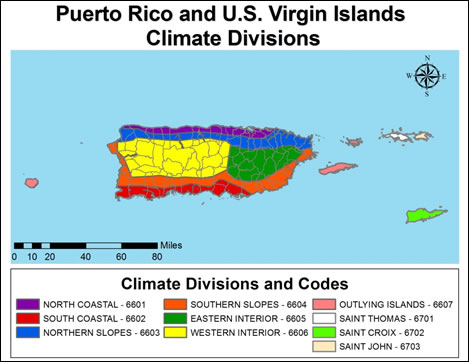
On this page you learn what types of flooding are typical in Puerto Rico and the U.S. Virgin Islands and how do you protect yourself, your family and your home. You will also find out more about significant floods in Puerto Rico and the U.S. Virgin Islands. Finally, you'll find links to NWS offices that provide forecast and safety information for Puerto Rico and the U.S. Virgin Islands as well as links to our partners who play a significant role in keeping you safe.
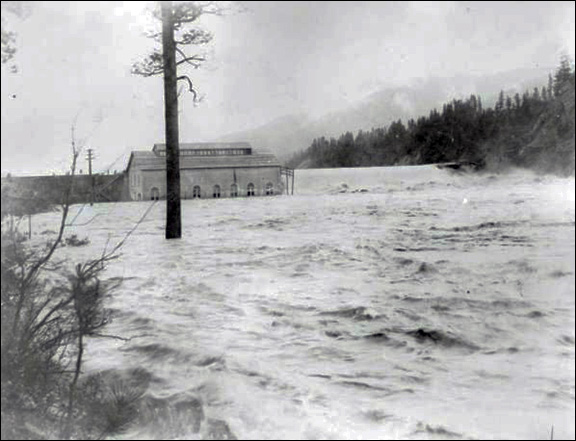
The USGS experienced gage house and equipment damages from this event. Many of the measurements were made indirectly but clearly they determined that the most severe floods occurred along the Rio Grande de Patillas and the Rio de La Plata from Comerio in the central interior headwaters to Toa Baja and Dorado along the north coast. At Rio de La Plata at Proyecto and Rio Grande de Patillas near Patillas, the peak flows exceeded the historical maximum stages and discharges. At Rio de La Plata at La Plata Dam, the water level rose 19 feet in 6 hours and downstream at Highway 2, the 110,000 cfs flow was a new record. Fajardo, Salinas, Ponce and Cayey were a few of the towns that experienced extensive flood damage during this event.
When the catastrophic event was over, there were 23 dead (20 in vehicles) and 167 injured. FEMA estimated total damages of $155 million (equivalent to $258 million 2013 dollars). Most of the deaths were due to drivers on winding mountainous roads during the flash floods, many of whom drove pass the civil defense emergency barricades.
“The catastrophic flash floods and river flooding which occurred in the Commonwealth of Puerto Rico on January 5 and 6 presented Federal, Commonwealth, and local officials with a worst-case scenario in which all aspects of the integrated warning program were severely tested.” (Excerpt from the Natural Disaster Survey Report- Puerto Rico Flash Floods January 5-6, 1992–U.S. Dept of Commerce, NOAA, and National Weather Service)
|
|
|
|
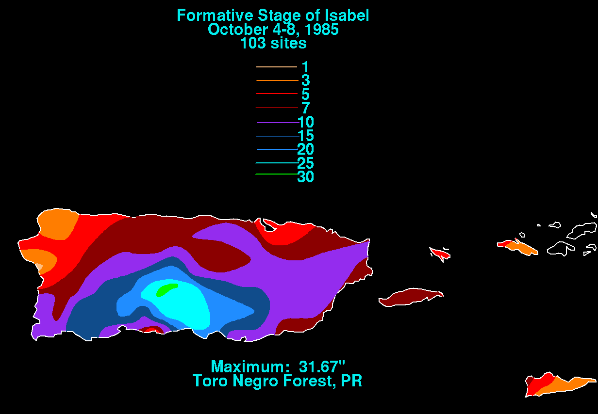
The floods of October 1985 were a couple of tragedies rolled into one. This event is remembered as the Mameyes Landslide which occurred on October 7 when a slab of calcareous sandstone (sandstone which turns to mud when saturated) detached from the side of a hill and slid into a downhill community, resulting in the destruction of 90 homes and the death of 130 people. This landslide is a subset of a larger event and resulted from saturated soils and heavy rains that occurred over the period of October 5–8, 1985.
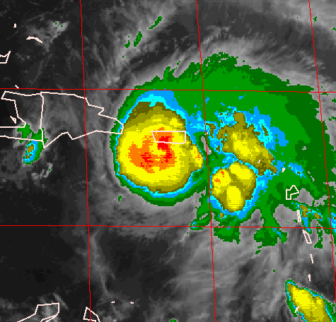
The floods of October 1985 proved disastrous because of the duration of the rainfall, the terrain and soil type. A nearly stationary tropical depression dropped over 31 inches of rain from October 4–8. The heaviest rainfall occurred October 6–7, when over 24 inches was recorded. The most severe floods were along the south central and eastern sections of the island. The rivers along the south coast of Puerto Rico are short with steep slopes and the intense rapid runoff during this event, when combined with the saturated sandstone, proved to be catastrophic in October 1985.
In addition to the deaths from the Mameyes Landslide, there were also approximately 40 additional fatalities directly and indirectly related to flash flooding. A number of people died when cars fell into Rio Coamo in the middle of the night after a portion of a bridge collapsed from raging waters. Property damage was estimated at $125 million dollars (equivalent to $271 million 2013 dollars).
Widespread flooding was reported from Ponce to Santa Isabel with record breaking flows recorded on Rios Coamo, Inabon, Descalabrado , Cerrillos and Portugues. The northern towns of Barceloneta, Toa Baja and Arecibo, with headwaters in the Cordillera Central Mountains, also experienced significant flooding during this event. The worst flooding was in the Rio Coamo basin, just west of Ponce.
This tropical wave moved northwestward and became Tropical Storm Isabel on October 8, 1985.
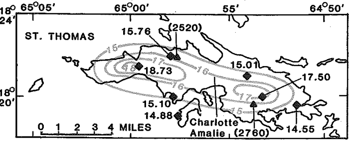
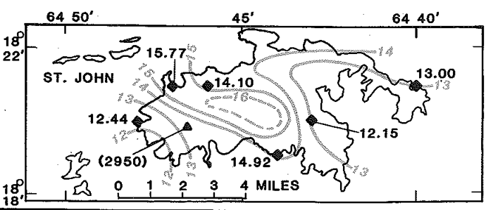
Images from Dept. of the Interior, USGS, Open-File Report 87-123 (see link below)

NWS rainfall analysis

Rainfall map Oct 4-8, 1985 for Mameyes Event, NWS data
Aerial View of Mameyes Landslide, Puerto Rico, R.W. Jibson, U.S. Geological Survey
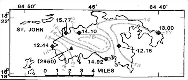
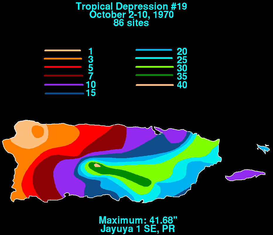
Another case of a slow moving tropical depression, resulting in rainfall over multiple days across the island, set the stage for the devastating floods of October 1970. The focus of the rainfall core shifted from day to day, but some areas experienced copious amounts of rainfall on consecutive days, causing rainfall amounts that could be measured in feet. The highest total over those 6 days was 38.42 inches at Jayuya and 41.68 inches at a station near Jayuya. Jayuya had a 24 hour total of 17 inches.
Flooding was widespread during the period. One of the hardest hit areas was the densely populated San Juan area. There were reports of bridge washouts, stranded vehicles, flooded homes, electrical outages and road closings due to both flood inundations and landslides.
The basins with the highest recorded flows were the Rio Grande de Manati at Ciales along the north coast and the Rio Espiritu Santo near El Verde in the northeast. The volume of runoff was a record for Puerto Rico since there were numerous peaks at various times during the flood duration. With the small basin sizes and the typical rains that occur across the region, rivers usually flood within 6 to 12 hours of the heaviest rain. These floods lasted days, creating unique challenges for the affected communities.
There were 18 confirmed fatalities, 34 people missing, $65 million (equivalent to $375 million 2013 dollars) worth of damage, 10,000 homeless citizens, 600 houses destroyed and another 1,000 damaged. The damage to agriculture alone was approximately $8 million with $12 million tallied for road and bridge damage. President Nixon declared the territory a disaster area; the worst in Puerto Rico’s history.

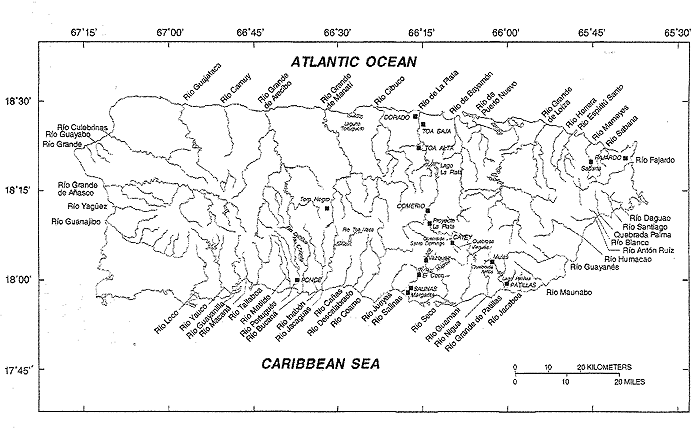
NWS Rainfall Data, October 2–10, 1970

Learn More:
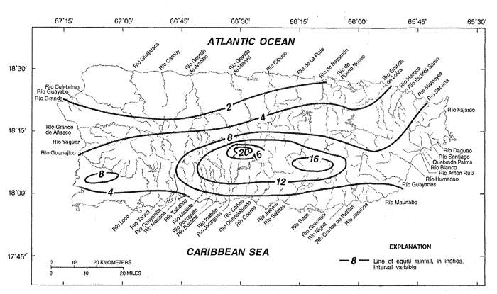
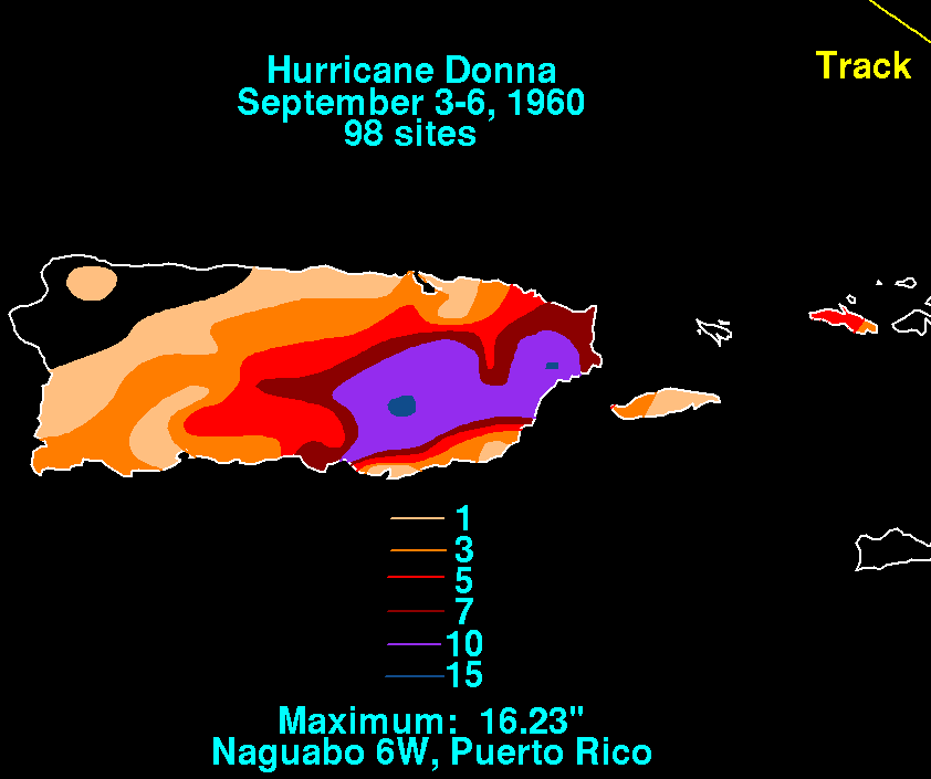
Historical records indicate that the floods across eastern Puerto Rico in September 1960 were some of the highest on record despite the fact that the rainfall amounts were not that extreme for the El Yunque rainforest, where the average yearly rainfall is around 120 inches. The key to these devastating floods was the intensity of that rainfall. A few stations measured 3 inches an hour for 2 to 3 hours during the night of September 5 into the morning of September 6. The highest rainfall amount of 18.76 was reported near Sabana, in the Luquillo Mountains (El Yunque rainforest). This high intensity rainfall covered a 15 to 40 square mile area from the central interior to the east coast of the island and was responsible for the overnight flash floods that drowned residents and demolished houses.
The most severe flash flooding occurred along Rios Grande de Manati, Grande de Loiza (and its tributaries), Humacao, Turabo, Gurabo, Valenciano, Blanco and Guayanes. The runoff from the Rio Grande de Loiza at San Lorenzo destroyed an entire community along its banks and contributed to the 42 foot rise just below the Loiza Dam in Trujillo Alto.
The flood wave continued downstream through Carolina, where a peak discharge of 197,000 cfs was measured at the Highway 3 Bridge, with continued high flow and flooding to the Atlantic Ocean along the north coast. Significant flooding was also noted on the Rio del La Plata from Comerio in the central interior to Dorado on the north coast, with a rise of 15 feet in one hour at the Toa Alta station. Many damaging landslides also occurred along the mountainsides during this event.
In Humacao, 90 people drowned from flash flooding on Rio Humacao during the early morning hours of September 6. There were a total of 117 deaths, 30 missing and 136 injured. Damage estimates exceeded $7 million (equivalent to $55 million 2013 dollars) with 484 houses destroyed, 3,600 damaged and over 8000 acres of agriculture ruined.
This rainfall was associated with Hurricane Donna which passed to the northeast of the island of Puerto Rico.


NWS rainfall plot

NWS Rainfall Data, Sep. 3–6, 1960

Photos likely form the local newspaper, El Mundo
Learn More:


Photos provided by Robin Koeppel Hepburn
Learn More:
 |
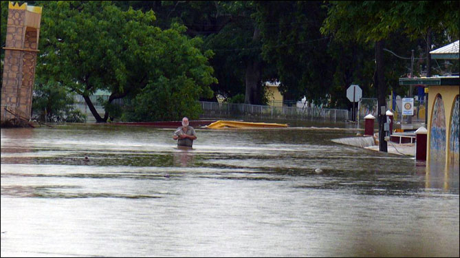
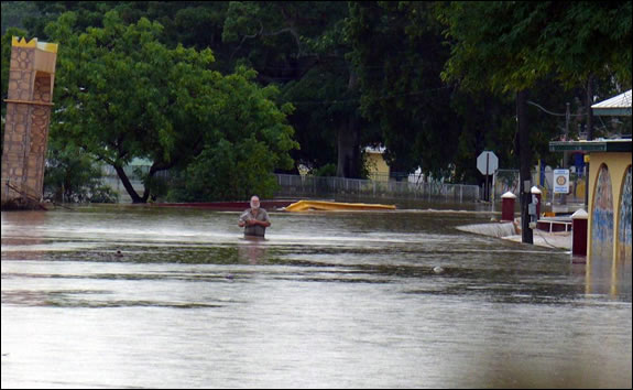 Credit Dave Davis- From St. Croix Source Newspaper, Frederiksted Flooding |
 Credit Bill Kossler- From St. Croix Source Newspaper, Frederiksted Flooding |
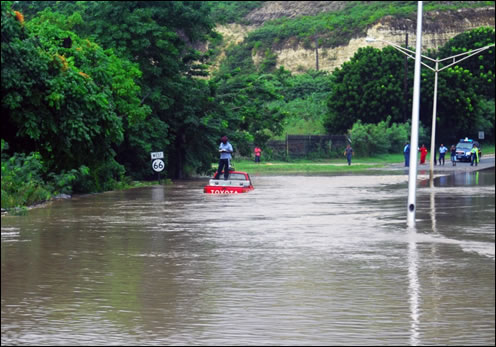
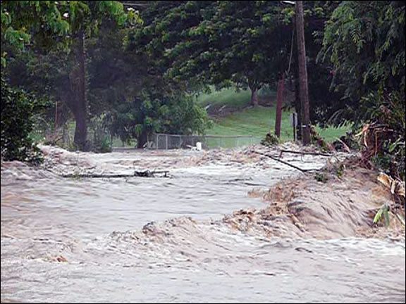 Credit Bill Kossler- From St. Croix Source Newspaper, Concordia Flooding |
Learn More:
| Protect Life and Property NWS Forecast Offices and River Forecast Center (RFC) Covering Puerto Rico and the U.S Virgin Islands |
||

