
Second Tornado Outbreak of April 2020
April 19, 2020
Summary of all Local Storm Reports (LSRs) on April 19th, as well as all the LSRs across the region for this event.
Storm survey teams preliminarily concluded that there were 6 tornadoes that occurred in our forecast area - 1 EF1 tornado in Baldwin County, AL, 3 EF1 tornadoes in Mobile County, AL, 1 EF2 tornado in Covington County, AL and 1 EF0 tornado in Santa Rosa County, FL.
The data provided on this page are considered preliminary as we continue to analyze all available data. We will add more information to this page and social media as it becomes available. We thank you in advance for your patience.
----- IMPORTANT 2023 UPDATE -----
Significant updates were made to several tornado tracks and wind swaths impacting the NWS Mobile/Pensacola area in the 2018 to 2023 timeframe thanks to the introduction of high-resolution Sentinel, Worldview, and Planet satellite imagery. One or multiple tornado tracks/wind swaths listed on this event webpage were updated in 2023.
An updated graphic and details surrounding these significant updates can be found further down on this webpage in the section for that specific tornado track or wind swath. More information on this Local Tornado Reanalysis Project and a list of all updates can be found on our webpage at weather.gov/mob/TornadoReanalysis or the National Damage Viewer.
Here is a list of the significant updates:
1. April 19, 2020 - Updated Tornado - Covington County, AL: The starting point of the EF2 tornado that occurred to the northeast of the Sanford community in Covington County, AL was extended further to the northwest based on widespread tree deforestation noted on Planet satellite imagery. The ending point was also extended further to the east based on notable tree damage in satellite imagery.

2. April 19, 2020 - New Damaging Wind Swath - Covington County, AL: A new swath of extensive tree damage separate from the tornado path consisting of at least numerous uproots and snaps was able to be found via high-resolution satellite imagery. Winds likely exceeded 90 to 100mph across this swath.

2. April 20, 2020 - New Damaging Wind Swath - Santa Rosa County, FL: High-resolution satellite imagery reveals a swath of wind damage likely upwards of 80 to 90mph with scattered to numerous trees uprooted and/or snapped across a broad swath. A brief EF-0 tornado was embedded within the damaging wind swath.

East-Central Baldwin County Tornado
Public Information Statement
National Weather Service Mobile AL
800 PM CDT Mon Apr 20 2020

...NWS Damage Survey For April 19, 2020 Tornado Event...

.East-Central Baldwin County Tornado...

Rating:                 EF-1
Estimated Peak Wind:    105 mph
Path Length /statute/:  0.47 miles
Path Width /maximum/:   300 yards
Fatalities:             0
Injuries:               1

Start Date:             Apr 19 2020
Start Time:             1146 PM CDT
Start Location:         8 miles NE of Robertsdale
Start Lat/Lon:          30.5903/-87.5818

End Date:               Apr 19 2020
End Time:               1147 PM CDT
End Location:           8 miles NE of Robertsdale
End Lat/Lon:            30.5887/-87.5741

The tornado touched down just west of Cowpen Creek Road and
continued east-southeast across the road. Numerous large
pines were snapped along the path. A couple of mobile homes
suffered damage to roofs, siding, and skirting. An RV camper
was picked up by the tornado and destroyed. One individual
suffered minor injuries. The tornado lifted just west of
Burgett Lane. Straight line wind damage continued farther
east-southeast across Burgett Lane and County Road 87.

EF Scale: The Enhanced Fujita Scale classifies
tornadoes into the following categories.

EF0...Weak......65 to 85 mph
EF1...Weak......86 to 110 mph
EF2...Strong....111 to 135 mph
EF3...Strong....136 to 165 mph
EF4...Violent...166 to 200 mph
EF5...Violent...>200 mph

Note:
The information in this statement is preliminary and subject to
change pending final review of the event and publication in
NWS Storm Data.
.png)
|
|
West-Central Mobile County Tornado

Public Information Statement
National Weather Service Mobile AL
913 PM CDT Mon Apr 20 2020

...NWS Damage Survey For April 19, 2020 Tornado Event...

.West-Central Mobile County Tornado...

Rating:                 EF-1
Estimated Peak Wind:    100 mph
Path Length /statute/:  8.70 miles
Path Width /maximum/:   100 yards
Fatalities:             0
Injuries:               0

Start Date:             Apr 19 2020
Start Time:             1055 PM CDT
Start Location:         1 mile SSW of Tanner Williams
Start Lat/Lon:          30.7092/-88.3781

End Date:               Apr 19 2020
End Time:               1106 PM CDT
End Location:           3 miles SSW of Mobile Regional Airport
End Lat/Lon:            30.6400/-88.2517

The tornado touched down just west of North Grand Bay Wilmer
Road and continued east-southeast to Eliza Jordan Road South,
then turned toward the southeast crossing over Airport Boulevard.
The most significant damage occurred after the tornado crossed
Airport Blvd. in the Wakefield and Dominion Subdivisions where
many homes suffered damage to roofs, siding, gutters, chimneys,
and porches. Numerous fences were brought down as well. The
tornado continued southeast before finally lifting just south
of Cottage Hill Road. Numerous trees were either snapped or
uprooted along the entire path.

EF Scale: The Enhanced Fujita Scale classifies tornadoes
into the following categories.

EF0...Weak......65 to 85 mph
EF1...Weak......86 to 110 mph
EF2...Strong....111 to 135 mph
EF3...Strong....136 to 165 mph
EF4...Violent...166 to 200 mph
EF5...Violent...>200 mph

Note:
The information in this statement is preliminary and subject
to change pending final review of the event and publication
in NWS Storm Data.

|

|
______________________________________________________________________________
Southwest Mobile County Tornado
Public Information Statement
National Weather Service Mobile AL
904 PM CDT Tue Apr 21 2020

...NWS Damage Survey For April 19, 2020 Tornado Event...

.Southwest Mobile County Tornado...

Rating:                 EF-1
Estimated Peak Wind:    90 mph
Path Length /statute/:  1.30 miles
Path Width /maximum/:   75 yards
Fatalities:             0
Injuries:               0

Start Date:             Apr 19 2020
Start Time:             1105 PM CDT
Start Location:         3 miles W of Dees
Start Lat/Lon:          30.5771/-88.3973

End Date:               Apr 19 2020
End Time:               1107 PM CDT
End Location:           2 miles W of Dees
End Lat/Lon:            30.5747/-88.3756

The tornado touched down just east of the Alabama/Mississippi state
line and tracked eastward before quickly lifting after it crossed
Tom Gaston Road. The tornado first toppled an irrigation watering
system, and then passed through two private residential properties
where it destroyed a barn, along with numerous broken branches and
a few snapped trees. The most significant damage occurred shortly
after to a private industrial property where three silos and a barn
were destroyed, three empty semi trailers were tipped over, and one
door of a large metal building was blown in and the other blown out.

EF Scale: The Enhanced Fujita Scale classifies
tornadoes into the following categories.

EF0...Weak......65 to 85 mph
EF1...Weak......86 to 110 mph
EF2...Strong....111 to 135 mph
EF3...Strong....136 to 165 mph
EF4...Violent...166 to 200 mph
EF5...Violent...>200 mph

Note:
The information in this statement is preliminary and subject to
change pending final review of the event and publication in NWS
Storm Data.
.png)
|

|
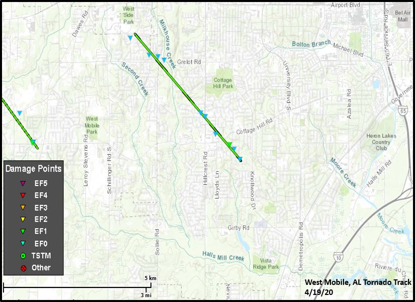
West Mobile Tornado (Mobile County, AL)
Public Information Statement
National Weather Service Mobile AL
813 PM CDT Tue Apr 21 2020

...NWS Damage Survey For April 19, 2020 Tornado Event...

.West Mobile Tornado...

Rating:                 EF-1
Estimated Peak Wind:    90 mph
Path Length /statute/:  3.10 miles
Path Width /maximum/:   75 yards
Fatalities:             0
Injuries:               0

Start Date:             Apr 19 2020
Start Time:             1106 PM CDT
Start Location:         2 miles SE of Mobile Regional Airport
Start Lat/Lon:          30.6684/-88.2154

End Date:               Apr 19 2020
End Time:               1112 PM CDT
End Location:           3 miles N of Tillmans Corner
End Lat/Lon:            30.6356/-88.1781

The tornado touched down just south of Hitt Road in the Smithfield
Subdivision and tracked southeast, crossing over the intersection of
Cody and Grelot Roads. It continued to move toward the southeast
across Hillcrest Road and Cottage Hill Road, and then finally lifted
just before reaching Knollwood Drive. Mostly tree damage occurred
with this tornado with numerous branches broken, with the most damage
occurring from Hillcrest Road until the tornado lifted where several
trees were snapped or uprooted. Some houses suffered structural damage
that were impacted by falling limbs or trees, and many fences were
brought down as well. Sporadic wind damage occurred from Knollwood
Drive to Government Boulevard after the tornado lifted.

EF Scale: The Enhanced Fujita Scale classifies
tornadoes into the following categories.

EF0...Weak......65 to 85 mph
EF1...Weak......86 to 110 mph
EF2...Strong....111 to 135 mph
EF3...Strong....136 to 165 mph
EF4...Violent...166 to 200 mph
EF5...Violent...>200 mph

Note:
The information in this statement is preliminary and subject to
change pending final review of the event and publication in
NWS Storm Data.
|

|
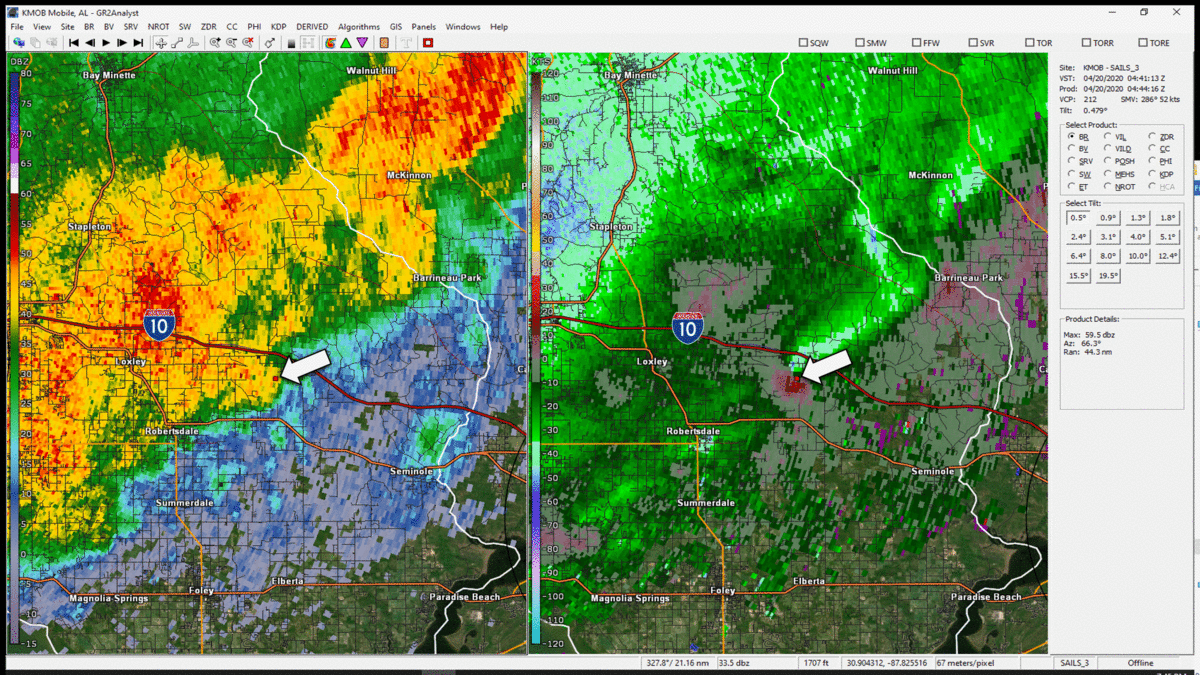
Covington County Tornado
Public Information Statement
National Weather Service Mobile AL
619 PM CDT Tue Apr 21 2020

...NWS Damage Survey For April 19, 2020 Tornado Event...

.Covington County Tornado...

Rating:                 EF-2
Estimated Peak Wind:    120 mph
Path Length /statute/:  1.2 miles
Path Width /maximum/:   300 yards
Fatalities:             0
Injuries:               1

Start Date:             Apr 19 2020
Start Time:             1049 pm CDT
Start Location:         5.3 miles NE of Andalusia AL
Start Lat/Lon:          31.3479/-86.3955

End Date:               Apr 19 2020
End Time:               1052 pm CDT
End Location:           5.9 miles ENE of Andalusia AL
End Lat/Lon:            31.3364/-86.3800

A tornado touched down just to the northwest of County Road 70
and traveled approximately one and a quarter of a mile towards
the southeast. The tornado rapidly intensified after touchdown
and produced EF-2 damage. A stand of pine trees were snapped
near the bases with no tree left undamaged. The tornado then
widened and severely damaged a duplex, sweeping it from its
foundation with portions of the debris lofted across C.R. 70
approximately 75 yards away. The duplex did not have proper
anchoring to the slab. A nearby concrete block workshop was
also destroyed with the roof removed and 26 foot high concrete
block walls toppled. A storage unit to the south was also
completely destroyed. This damage was assessed as EF-2 tornado
intensity.

Across C.R. 70, another single family home was significantly
damaged. Large portions of the roof were removed along with
partial wall failure. Doors and windows were blown in at the
home. This damage was assessed as EF-1 intensity.

The tornado continued southeastward and heavily damaged
another stand of mixed softwood and hardwood trees, with many
of them snapped either near the base or one quarter of the
way up. This damage was assessed as EF-2 tornado intensity.
Immediately beyond the tree damage was a metal garage building
where the roof was partially removed and a complete wall was
ripped off.

The tornado traveled farther southeast through a wooded area
and came out into a pasture where it severely damaged and
destroyed 4 large chicken houses. The chicken house walls were
bolted into the foundation and were completely removed in
several locations. This tornado damage was assessed at EF-2
intensity.

The tornado began to weaken as it crossed Harmony Church Road
and dissipated just to the southeast where trees were snapped
and uprooted just prior to the end of the tornado track. EF-1
damage was assessed prior to tornado dissipation.

EF Scale: The Enhanced Fujita Scale classifies
tornadoes into the following categories.

EF0...Weak......65 to 85 mph
EF1...Weak......86 to 110 mph
EF2...Strong....111 to 135 mph
EF3...Strong....136 to 165 mph
EF4...Violent...166 to 200 mph
EF5...Violent...>200 mph

Note:
The information in this statement is preliminary and subject to
change pending final review of the event and publication in
NWS Storm Data.

|

|
Pace, FL Tornado and Straight Line Winds
Public Information Statement
National Weather Service Mobile AL
556 PM CDT Tue Apr 21 2020

...NWS Damage Survey For April 20, 2020 Tornado Event...

.Pace, FL Tornado and Straight Line Winds...

Rating:                 EF-0
Estimated Peak Wind:    75 mph
Path Length /statute/:  0.2 miles
Path Width /maximum/:   50 yards
Fatalities:             0
Injuries:               0

Start Date:             Apr 20 2020
Start Time:             1207 am CDT
Start Location:         1.6 miles WNW of Pace FL
Start Lat/Lon:          30.60789/-87.18695

End Date:               Apr 20 2020
End Time:               1208 am CDT
End Location:           1.4 miles WNW of Pace FL
End Lat/Lon:            30.60699/-87.18388

NWS Storm Survey found that most of the wind damage that occurred
in Pace, FL was the result of 70-80 mph straight line winds. This
resulted in numerous downed trees across the city as well as roof
damage to some residences. The survey also found a brief EF-0
tornado track from Ephrem Ln to Bradley Dr in the city of Pace. In
this area, convergence in tree damage was noted, while across the
rest of Pace, the damage was found to be all in one direction

EF Scale: The Enhanced Fujita Scale classifies
tornadoes into the following categories.

EF0...Weak......65 to 85 mph
EF1...Weak......86 to 110 mph
EF2...Strong....111 to 135 mph
EF3...Strong....136 to 165 mph
EF4...Violent...166 to 200 mph
EF5...Violent...>200 mph

Note:
The information in this statement is preliminary and subject to
change pending final review of the event and publication in
NWS Storm Data.

|

|
Acknowledgements: Page created by Joe Maniscalco (Forecaster). Page updated by Caitlin Baldwin and Michael Mugrage (Forecaster).
LAST UPDATED: March 2024


 Follow us on YouTube