
Mid-March Severe Event
March 18, 2022
Summary of all Local Storm Reports (LSRs) on March 18th, as well as all the LSRs across the region for this event. Storm survey teams preliminarily concluded that there was one EF-1 tornado in addition to a swath of straight-line wind.
The data provided on this page are considered preliminary as we continue to analyze all available data. We will add more information to this page and social media as it becomes available. We thank you in advance for your patience.
Okaloosa County, FL Tornado
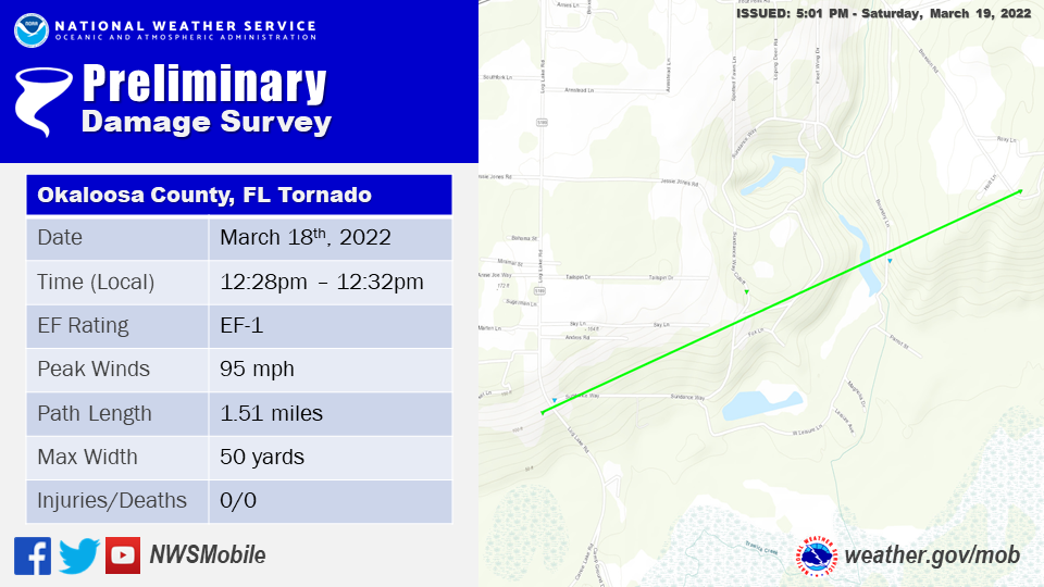
Public Information Statement
National Weather Service Mobile AL
438 PM CDT Sat Mar 19 2022

...NWS Damage Survey for 03/18/22 Tornado Event...

.Okaloosa County, FL Tornado...

Rating:                 EF1
Estimated Peak Wind:    95 mph
Path Length /statute/:  1.5059 miles
Path Width /maximum/:   50.0 yards
Fatalities:             0
Injuries:               0

Start Date:             03/18/2022
Start Time:             12:28 PM CDT
Start Location:         2 S Holt / Okaloosa County / FL
Start Lat/Lon:          30.6823 / -86.7515

End Date:               03/18/2022
End Time:               12:32 PM CDT
End Location:           2 SE Holt / Okaloosa County / FL
End Lat/Lon:            30.6903 / -86.728

Survey Summary:
A tornado touched down just west of the intersection of Log Lake
Road and Sundance Way. The tornado damaged the roof of a house
where numerous shingles were removed down to the tar paper. In
addition, a manufactured home adjacent to the house was destroyed.
Numerous trees were snapped and several trees were uprooted. The
tornado proceeded east across Log Lake Road and damaged the roof
of a manufactured home as well as snapped and twisted additional
trees. A couple trees were also uprooted. The tornado continued
along and crossed Sundance Way Cutoff Road where several more
trees were snapped and uprooted. From there, the tornado
progressed northeast and hit a home, ripping off a portion of the
roof to include the decking underneath. This was thrown roughly 50
yards away into the front yard and into trees. Several large
trees were also snapped near the base and twisted. A few more were
uprooted as well. The tornado then lifted just beyond this
property. Overall, the maximum width of the tornado reached 50
yards with a path length of about 1.5 miles.

The National Weather Service in Mobile, AL would like to thank
the Okaloosa County Emergency Management Agency for assisting with
the preliminary damage maps.

&&

EF Scale: The Enhanced Fujita Scale classifies tornadoes into the
following categories:

EF0...Weak......65 to 85 mph
EF1...Weak......86 to 110 mph
EF2...Strong....111 to 135 mph
EF3...Strong....136 to 165 mph
EF4...Violent...166 to 200 mph
EF5...Violent...>200 mph

NOTE:
The information in this statement is preliminary and subject to
change pending final review of the event and publication in NWS
Storm Data.
The photos below were taken during the tornado survey in Okaloosa County and show the extent of the damage along the path of the tornado.


Poarch, AL Wind Event
Public Information Statement
National Weather Service Mobile AL
203 PM CDT Sat Mar 19 2022

...NWS Damage Survey for 03/18/22 Thunderstorm Wind Event...


.Poarch AL Wind Event...

Peak Wind:              90-100 mph
Fatalities:             0
Injuries:               10

Event Date:             March 18, 2022
Event Time:             904 am
Event Location:         Poarch AL

Survey Summary: A swath of damaging straight line winds impacted
the Poarch, AL area on 3/18/22 at 9:04 AM CDT. A narrow swath of
intense wind gusts estimated at 90 to 100mph affected a mobile
home park where several mobile homes were rolled/destroyed. The
surrounding area sustained severe wind gusts to the southeast
where several trees were snapped/uprooted and a farm and nearby
residences sustained roof damage to several buildings. The survey
team found no evidence of convergence with all damage laid out in
a southwest to northeast swath suggesting straight line wind
damage.

&&

NOTE:
The information in this statement is preliminary and subject to
change pending final review of the event and publication in NWS
Storm Data.
The photos below were taken during the tornado survey in the Poarch community and show some of the straight-line wind damage.

Additional Information
Acknowledgements: Page created by Christina Leach (Forecaster) and Morgan Barry (Forecaster). Updated by Michael Mugrage (Forecaster).
LAST UPDATED: March 2024


 Follow us on YouTube