
Hurricane Elena - September 2, 1985
 Elena began as an organized cloud pattern on satellite imagery that moved west out of the Saharan Desert. Elena was first identified on satellite imagery north of the Cape Verde Islands on the August 23rd of 1985. Elena wasted no time and quickly traveled west across the Atlantic Ocean at an unusually high forward speed of 30-35mph. This system's forward speed combined with the dry Saharan Air Layer managed to inhibit any significant tropical formation until Elena approached the island of Cuba on August 27th. By the 28th of August, reconnaissance aircraft measured 50-60mph winds across the northern periphery of Elena, which warranted Elena's upgrade to tropical storm status.
Elena quickly strengthened into a hurricane as it moved into the Gulf of Mexico on August 29th. Similar to Hurricane Juan, which would strike the northern Gulf Coast the very next month, Hurricane Elena had a very unique path. A cold front approached Elena from the northwest, which collapsed the steering currents and caused Elena to re-curve toward the west coast of Florida (instead of heading toward the north central Gulf coast). As Elena approached the Tampa Bay and Cedar Key sections of the western Florida coastline, high pressure began to steer Elena back toward the west.
Elena intensified and accelerated off to the west-northwest and was upgraded to a major hurricane by the afternoon of September 1st. A view of Elena from the Space Shuttle Discovery on the 1st can be seen in the top image on the right (photo  courtesy of NASA). Visible satellite imagery of Elena early on the 1st as it made its turn back to the west can be viewed in the bottom image on the right. Hurricane Elena made landfall near Biloxi, MS on September 2nd.
Although Elena did not make landfall across our area, the eyewall moved close enough to our coastal counties to result in major wind and storm surge damage.
The worst wind damage occurred along the immediate coastline due to its location with respect to the eastern side of the eyewall and where the wind fetch was relatively long. This wind damage can be visualized in the graphic below (courtesy of D.J. Stiegler and B. E. Smith, University of Chicago and NOAA AOML/HRD). This wind damage map shows wind speeds of 75+ mph across the southern portion of Mobile and Baldwin Counties in Alabama and Escambia County in northwest Florida, as well as across all of Stone County in southern Mississippi. Closer to the coast, wind speeds were estimated at 100+ mph for locations generally south of I-10 in Mobile County and along the immediate coastline in Baldwin County, AL. The eyewall of Elena came very close to Dauphin Island as winds of 125+ mph winds were experienced across the island.

Dauphin Island suffered the brunt of the storm. Storm surge was measured at 8.4 feet on the Gulf side and 3.5 feet on the bay side of Dauphin Island. Storm surge cut all the way across low lying parts of the island with severe beach erosion and damage to roads. In fact, the storm surge eroded streets, which exposed and destroyed the water and sewer pipelines underground. Additionally, beach erosion was severe along the coastline of Mobile and Baldwin Counties. Most of the damage in Baldwin County occurred on Pleasure Island and on the Fort Morgan Peninsula.
Many homes along Dauphin Island were almost completely blown away in the wind. This is an excerpt from Storm Data describing what occurred on Dauphin Island:
Damage to buildings was described as worse than that from Hurricane Frederic
that hit 6 years earlier, in September 1979. Typical houses were splintered by the
hurricane force winds that battered the island for an estimated 3 hours. Wind
equipment at Dauphin Island Sea Lab was reported damaged at 251CST and
failed at 336CST, but not before a peak gust of 122mph was recorded at 308CST.
Sea Lab officials estimated a gust of 132mph at 333CST using a best fit curve
from the available data on the recorded chart. Hurricane force winds were recorded
from 235CST until the equipment failure at 336 CST and were estimated to have
continued until 535CST.
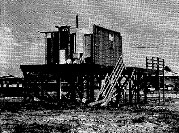
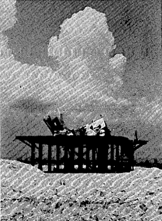
Further inland across Mobile County, a peak gust of 84mph was recorded at the Emergency Operations Center in Mobile and a peak gust of 60mph was recorded at the NWS Office (located at Bates Field at that time). Inland across Mobile and Baldwin Counties in Alabama and across the inland southern Mississippi counties, the damage was confined to downed trees and powerlines with some buildings sustaining damage from downed trees. The black and white photographs below were taken from the official Storm Data by D.J. Stiegler and B. E. Smith of the University of Chicago while doing the wind damage survey in 1985.

The oyster crop in Alabama sustained extensive damage with more than half of the crop estimated lost. The pecan crop also suffered a major blow and, much like the oyster beds, pecan growers were still recovering from the previous hurricane in 1979 - Hurricane Frederic. In addition to the immediate loss of some 8 million pounds of pecans, many trees would take several years to replace, were lost. Other crop loses included an estimated 10% of the soybean crop.

Additional Information
RESEARCH
The Structure and Evolution of Hurricane Elena (1985). Part I: Symmetric Intensification - Monthly Weather Review
Authors: Kristen L. Corbosiero (Univ of Albany), John Molinara (Univ of Albany), Michael L. Black (NOAA AOML/HRD)
The Structure and Evolution of Hurricane Elena (1985). Part II: Convective Asymmetries and Evidence for Vortex Rossby Waves - Monthly Weather Review
Authors: Kristen L. Corbosiero (Univ of Albany), John Molinara (Univ of Albany), Michael L. Black (NOAA AOML/HRD)
WPC Archive
Monthly Weather Review - Atlantic Hurricane Season of 1985
NOAA Digital Coast - Hurricane Elena Track
Acknowledgements: Page created by Morgan Barry (forecaster).
LAST UPDATED: September 2022


 Follow us on YouTube