

Schedule
| City | Date | Time | Address |
|---|---|---|---|
| Eads, CO | February 20, 2024 | 6:00p - 8:00p | 1305 Goff Street PO Box 353. Eads, CO 81036 |
| Pueblo, CO | March 4th, 2024 | 5:30p - 7:30p | 101 West 10th Street Pueblo, CO 81003 |
| Lamar, CO | March 5th, 2024 | 6:00p - 8:00p | 2517 Saddle Club Drive Lamar, CO 81052 |
| Colorado Springs, CO | March 20th, 2024 | 6:00p - 8:00p | 3755 Mark Dabling Boulevard Colorado Springs, CO 80907 |
| Alamosa, CO | April 1st, 2024 | 5:30p - 7:30p | 1301 West Avenue, Alamosa, CO 81101 |
| Cañon City, CO | April 3rd, 2024 | 5:30p - 7:30p | 1901 East Main Cañon City, CO 81212 |
| Rocky Ford, CO | April 4th, 2024 | 5:30p - 7:30p | 300 South Main Street Rocky Ford, CO 81067 |
For more information contact:
Warning Coordination Meteorologist
Klint Skelly
Phone: 719-948-9429 or
E-mail: Klint.Skelly@noaa.gov
About SKYWARN
What is SKYWARN®?
The effects of severe weather are felt every year by many Americans. In most years, thunderstorms, tornadoes and lightning caused hundreds of injuries and deaths and billions in property and crop damages. To obtain critical weather information, the National Weather Service (NWS) established SKYWARN® with partner organizations. SKYWARN® is a citizen volunteer program with between 350,000 and 400,000 trained severe weather spotters. SKYWARN® storm spotters are citizens who form the nation's first line of defense against severe weather. These volunteers help keep their local communities safe by providing timely and accurate reports of severe weather to the National Weather Service.
Although SKYWARN® spotters provide essential information for all types of weather hazards, the main responsibility of a SKYWARN® spotter is to identify and describe severe local storms. In an average year, the the United States experiences more than 10,000 severe thunderstorms, 5,000 floods and more than 1,000 tornadoes.
Since the program started in the 1970s, the information provided by SKYWARN® spotters, coupled with Doppler radar technology, improved satellite and other data, has enabled NWS to issue more timely and accurate warnings for tornadoes, severe thunderstorms and flash floods. Storm spotters play a critical role because they can see things that radar and other technological tools cannot, and this ground truth is critical in helping the NWS perform our primary mission, to save lives and property.
The SKYWARN® Program at NWS Pueblo
Across Southern Colorado, dedicated volunteers risk their personal safety to provide first-hand severe weather reports to their local officials, and the National Weather Service (NWS) in Pueblo. Their reason, to help protect the lives and property of the citizens in Southern Colorado.
Being a storm spotter not only means dedication, but also training. Each spring the NWS in Pueblo trains members of the public, police, fire department, emergency management, and amateur radio community, in the latest storm spotting techniques, basic weather concepts, and preparedness and planning. Typically the training is coordinated by a local group such as an emergency management agency or HAM radio operator. A NWS meteorologist serves as the guest instructor.
The goal of the training is to prepare the spotter to identify hazardous weather conditions, how to report that information to the local NWS, and personal safety.
There are also a number of in-person seminars scheduled. These seminars are free of charge and many are open to the public. Each seminar is approximately 1 to 1 1/2 hours in length and most often held in evening on a weekday. We ask that you pre-register for the classes in order to get a better head count on attendance. You are allowed to attend classes outside your county of residence. If needed, training certificates are provided at each class. We no longer issue Spotter IDs.
For more information contact:
Warning Coordination Meteorologist
Klint Skelly
Phone: 719-948-9429 or
E-mail: Klint.Skelly@noaa.gov
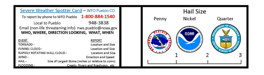
Certificate/Hail Card
What to Report
When to send a storm report?
When you can do safely, please send us a report when you observe one or more of the following:
- Tornado (confirm rotation)
- Funnel cloud (confirm rotation)
- Hail (any size)
- 0.25" or less - Pea
- 0.50" - Mothball
- 0.75" - Dime/Penny
- 0.88" - Nickel
- 1.00" - Quarter
- 1.25" - Half Dollar
- 1.50" - Walnut/Ping Pong
- 1.75" - Golf Ball
- 2.00" - Hen Egg
- 2.50" - Tennis Ball
- 2.75" - Baseball
- 3.00" - Tea Cup
- 4.00" - Grapefruit
- 4.50" - Softball
- Wind damage. What is damaged? Number of trees down? Are they snapped, uprooted? Large branches, small branches?
- Flooding Include pictures if you can. How deep is the water (use what is around you as a guide, i.e water up to the bumpers).
- Snowfall greater than 1 inch
- Rainfall (Generally 1" or greater in 24 hours -or- 0.5" in less than an hour.
How to send us a storm report.
- Call the NWS Pueblo Public Service Line
For life-threatening and imminent severe weather threats, please contact our forecast office immediately (even if you also contact us by social media or email) through our 24-hour public service phone line at 719-948-9429.
- Submit a Storm Report Online via the NWS Norman Facebook or Twitter websites.
- mPING App
- The Spotter Network
- Email
Email us your report with images if possible – You may also pass along additional information such as delayed reports and weather and damage pictures by e-mailing them to the NWS Pueblo office.
Definitions:
- Tornado: A violently rotating column of air, usually pendant to a cumulonimbus, with circulation reaching the ground. It nearly always starts as a funnel cloud and may be accompanied by a loud roaring noise. On a local scale, it is the most destructive of all atmospheric phenomena.
- Severe Thunderstorm: A thunderstorm that produces a tornado, winds of at least 58 mph (50 knots), and/or hail at least 1" in diameter. Structural wind damage may imply the occurrence of a severe thunderstorm. A thunderstorm wind equal to or greater than 40 mph (35 knots) and/or hail of at least ½" is defined as approaching severe.
- Flash Flood: A flood which is caused by heavy or excessive rainfall in a short period of time, generally less than 6 hours. Also, at times a dam failure can cause a flash flood, depending on the type of dam and time period during which the break occurs.
Please include in your report, the location (town and county) and time/date that the severe weather occurred.
If you can supply a picture of the severe weather you are experiencing, please do.
For more information contact:
Warning Coordination Meteorologist
Klint Skelly
Phone: 719-948-9429 or
E-mail: Klint.Skelly@noaa.gov
YouTube
Local SKYWARN Class Recordings
Skywarn Basic Course in Spanish (4 parts)
This course is NOT produced by your local NWS office in Pueblo.
Becoming a Skywarn Spotter just became easier with the development of the online Skywarn Spotter Training Course. There are two courses, including: "Role of the Skywarn Spotter" and "Skywarn Spotter Convective Basics".
These courses cover the basics of being a Skywarn Spotter. They are free and accessible from the METED website. www.meted.ucar.edu
If you live within the NWS Pueblo Forecast area, and you've complete these two online courses, e-mail your certificate to Klint.Skelly@noaa.gov, and you will receive our local spotter line information and an electronic version of our Spotter card.
For more information contact:
Warning Coordination Meteorologist
Klint Skelly
Phone: 719-948-9429 or
E-mail: Klint.Skelly@noaa.gov
 Follow us on YouTube