|
JANUARY 1-2, 1999 |
|
research by Robert B. Darby, forecaster & Raymond J. Sondag, forecaster |
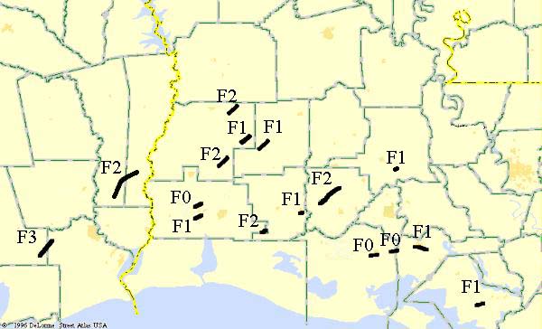
| Map of all tornadoes in the outbreak |
 |
| Local Storm Reports |
OVERVIEW
On the night of January 1-2, 1999, Southeast Texas and Southern Louisiana experienced the biggest known tornado outbreak ever recorded in this region of the country. At least 16 tornadoes occurred across the area, with one reaching F3 intensity on the Fujita scale. Five F2 tornadoes also occurred during the event. The last time an outbreak of this magnitude occurred in Southeast Texas and Southern Louisiana was on November 7, 1957, where eight tornadoes struck, five of which were F3 intensity or higher.
During the evening hours on January 1, 1999 a strong upper level disturbance moved into Southeast Texas. In conjunction with this feature, a surface low developed over North-central Texas with a strong cold front extending southward. Ahead of the surface low, a low level jet developed with strong veering winds in the lowest levels of the atmosphere. Warm, moist air from the Gulf of Mexico moved onshore causing the atmosphere to become increasingly unstable. The strong low level winds and increasing instabilities set the stage for a series of strong rotating thunderstorms.
Numerous watches and other products were issued on January 1, 1999, advising the public of the potential for severe weather. Of the 18 warnings issued during the outbreak, all verified with either a tornado touchdown or damaging downburst winds. There was only one missed warning, where straight line winds caused damage to a few homes and sheds in the communities of Anacoco and Hornbeck in Vernon Parish. All of the tornadoes were radar indicated by the WSR-88D radars in Lake Charles and Fort Polk, Louisiana. Average lead time on the tornado warnings was an impressive 24 minutes. (Note: lead time is defined as: the time between the issuance of the warning and actual tornado touchdown.) However, because the majority of the tornadoes occurred in the middle of the night, many residents were sleeping, without any knowledge of the imminent danger. Persons who owned a NOAA Weather Radio, with an alert feature, would have received the tornado warnings as soon as they were issued by the NWS. This would have alerted them to seek shelter from the storms before they hit. Unfortunately, one fatality occurred in a mobile home near the community of Buna, Texas. Given the severity of the tornadoes and the time of occurrence, it is fortunate that more people were not seriously injured or killed.
|
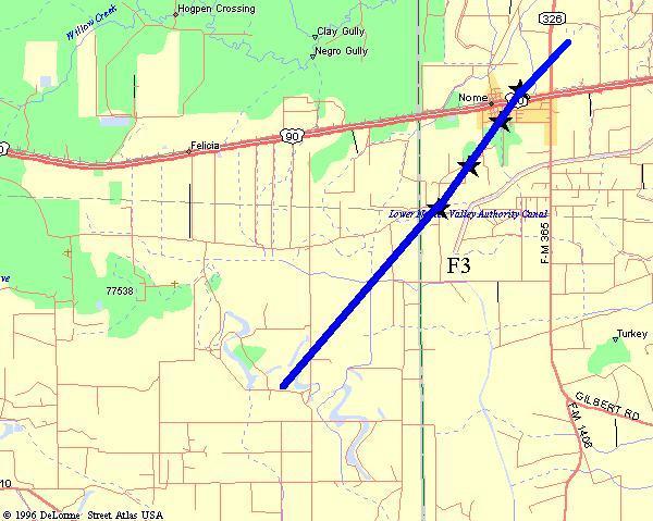
Nome Tornado |
||
 |
||
| DATE: 1/1/99 | RATING: F3 | FATALITIES: 0 |
| TIME: 1032 AM | PATH LENGTH: 10 miles | INJURIES: 5 |
| COUNTIES: Liberty/Jefferson | PATH WIDTH: 400 yards | TORNADO WARNING: 1144 PM |
| STATE: Texas | DAMAGE: $675,000 | LEAD TIME: 1 minute |
|
DESCRIPTION: This tornado appeared to have formed just on the other side of a canal in the Dunning's Farm area. At this point three large houses were completely destroyed with widespread tree damage. The tornado moved NE and dragged heavy farm tractors (approximately 50000 lbs) over 10 to 15 feet. The tornado moved across a wide open field and crossed into Jefferson county. As the strong tornado moved across western Jefferson County, it destroyed several rice dryers, two mobile homes, and a brick house. Five people were injured in the mobile homes and brick house. Two people received broken necks and other injuries after they were ejected from one of the mobile homes. A fiberglass tub from the destroyed brick home was found one mile away. Cancelled checks and other paperwork were found seven miles away in southern Hardin County. This tornado was strongest southwest of Nome, and was weakening as it passed through the small community of Nome. At least 20 homes received minor damage such as shingles blown off, and many trees were blown down. |
||
|
|
|
|
|
|
|
|
|
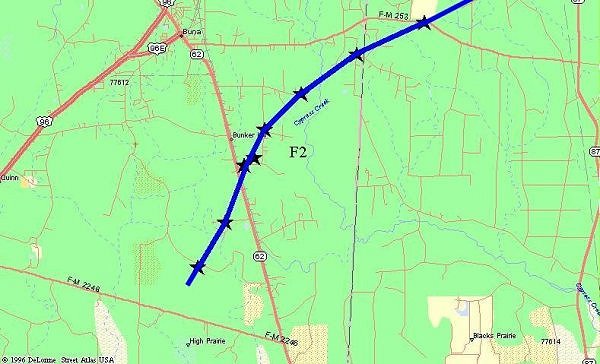
Buna Tornado |
||
 |
||
| DATE: 1/2/99 | RATING: F2 | FATALITIES: 1 |
| TIME: 1245 AM | PATH LENGTH: 13 miles | INJURIES: 10 |
| COUNTIES: Jasper/Newton | PATH WIDTH: 800 yards | TORNADO WARNINGS: 1226 AM, 1235 AM |
| STATE: Texas | DAMAGE: $1,500,000 | LEAD TIME: 19 minutes |
|
DESCRIPTION: An F2 tornado began 6 miles east of Evadale and moved northeast across southern Jasper County. At least 15 homes were destroyed, 20 received major damage, and 10 received minor damage. The worst hit area was Callier Loop, south of Buna. A tied down mobile home rolled over at least five times, ejecting a man 100 yards and a woman 500 yards. The man received a broken back and other serious injuries, while the woman died a few days later from a broken neck, back, and internal injuries. Debris from this home was spread over a mile across the fields. Brick walls were cracked in permanent homes, pickup trucks were lifted in the air and pushed 20 feet from where they originally were parked, and any mobile home situated lengthwise north to south was rolled over and destroyed. There were several stories of people being ejected from their mobile homes, and walking away with minor injuries. The tornado then moved into Newton County, and did significant damage to forested lands in rural Newton County. Total path length for both Jasper and Newton Counties is 12.5 miles. |
||
|
|
|
|
|
|
|
|
|
|
|
|
|
|
|
|
|
Sulphur Tornado |
||
| DATE: 1/2/99 | RATING: F0 | FATALITIES: 0 |
| TIME: 105 AM | PATH LENGTH: 3 miles | INJURIES: 0 |
| PARISH: Calcasieu | PATH WIDTH: 100 yards | TORNADO WARNING: 1251 AM |
| STATE: Louisiana | DAMAGE: $25,000 | LEAD TIME: 14 minutes |
|
DESCRIPTION: A small tornado touched down north of Sulphur in the Houston River Road area, blowing down trees and power lines. |
||
|
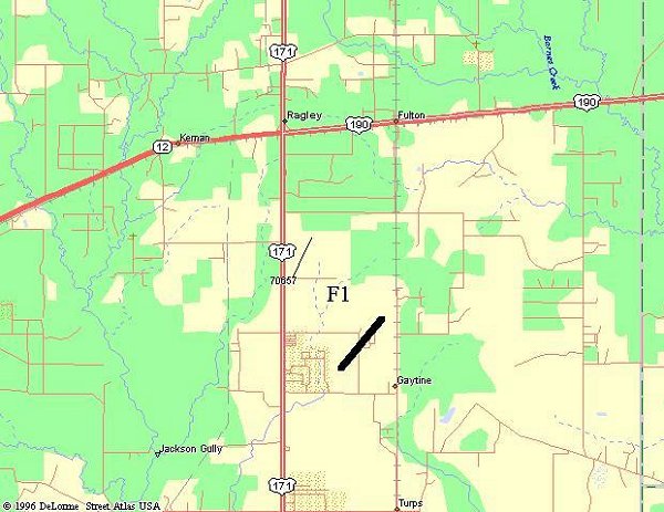
Ragley Tornado |
|||
 |
|||
| DATE: 1/2/99 | RATING: F2 | ||
| TIME: 125 AM | PATH LENGTH: 1 miles | ||
| PARISH: Beauregard | PATH WIDTH: 100 yards | ||
| STATE: Louisiana | DAMAGE: $50,000 | ||
| TORNADO WARNING: 116 AM | FATALITIES: 0 | ||
| LEAD TIME: 9 minutes | INJURIES: 0 | ||
|
DESCRIPTION: A small but strong tornado moved across rural areas south of Ragley. One new mobile home that was in the path was completely destroyed. Debris was scattered for over a mile. The residents had heard the warnings and escaped the home minutes before it was destroyed. |
|||
|
|
|
||
|
|
|
|
|
|
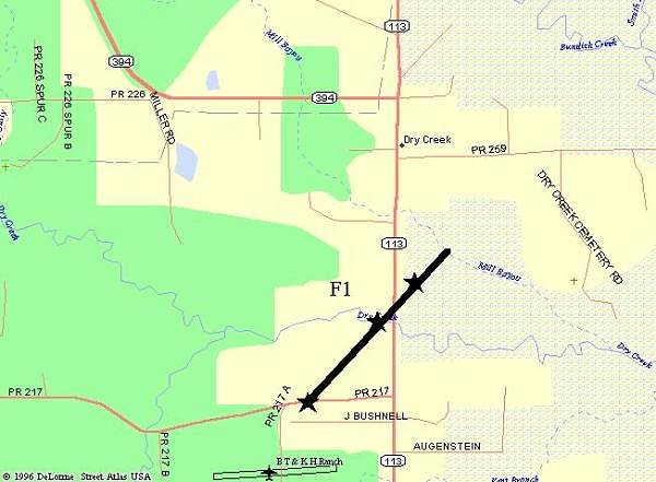
Dry Creek Tornado |
||
 |
||
| DATE: 1/2/99 | RATING: F1 | FATALITIES: 0 |
| TIME: 150 AM | PATH LENGTH: 3 miles | INJURIES: 0 |
| PARISH: Beauregard | PATH WIDTH: 400 yards | TORNADO WARNING: 116 AM |
| STATE: Louisiana | DAMAGE: $50,000 | LEAD TIME: 34 minutes |
|
DESCRIPTION: This tornado touched down 4 miles south of Dry Creek, moving northeast at 40 mph. The most substantial damage occurred when a home had the roof completely ripped off. The debris was picked up and carried over 200 yards into a nearby field. The home also sustained water damage due to the heavy rain. The family took cover in an interior hallway just before the tornado hit. None of the family members sustained any injuries. Numerous trees were also ripped up and twisted along the tornado path near Highway 113. |
||
|
|
|
|
|
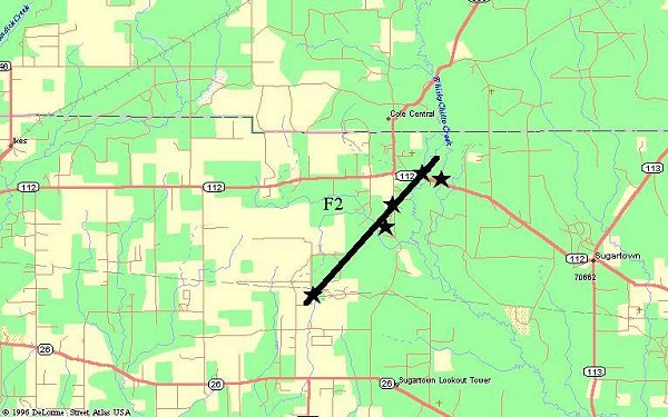
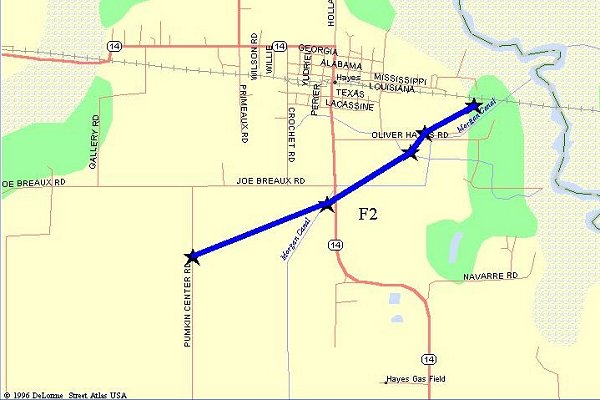
Sugartown Tornado |
|||
 |
|||
| DATE: 1/2/99 | RATING: F2 | ||
| TIME: 150 AM | PATH LENGTH: 5 miles | ||
| PARISH: Beauregard | PATH WIDTH: 400 yards | ||
| STATE: Louisiana | DAMAGE: $50,000 | ||
| TORNADO WARNING: 116 AM | FATALITIES: 0 | ||
| LEAD TIME: 9 minutes | INJURIES: 0 | ||
|
DESCRIPTION: This tornado originally touched down 4 miles west of Sugartown, damaging one home. it continued northeast and intersected Highway 113 near the Whiskey Chitto Creek bridge. A large swath of large trees were sheared off and twisted. A few homes in this area received roof damage. A large trampoline was found 20 feet in the air, wrapped around a tree. |
|||
|
|
|
|
|
|
Carlyss Tornado |
||
 |
||
| DATE: 1/2/99 | RATING: F1 | FATALITIES: 0 |
| TIME: 150 AM | PATH LENGTH: 3 miles | INJURIES: 0 |
| COUNTIES: Calcasieu | PATH WIDTH: 50 yards | TORNADO WARNINGS: 1251 AM |
| STATE: Louisiana | DAMAGE: $75,000 | LEAD TIME: 59 minutes |
|
DESCRIPTION: The Carlyss tornado developed from a supercell thunderstorm that moved northeast out of Cameron Parish. It touched down near the Air Liquide plant, causing structural damage to the compressor building at the plant. |
||
|
|
|
|
|
|
|
|
|
|
|
|
|
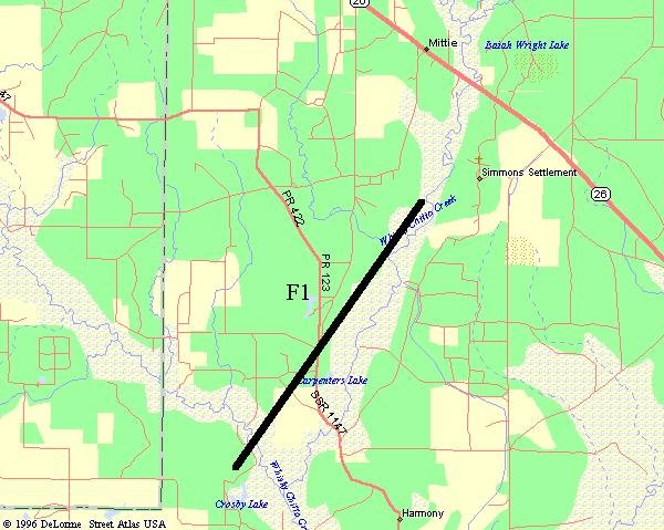
Mittie Tornado |
||
 |
||
| DATE: 1/2/99 | RATING: F1 | FATALITIES: 0 |
| TIME: 220 AM | PATH LENGTH: 2 miles | INJURIES: 0 |
| PARISH: Allen | PATH WIDTH: 200 yards | TORNADO WARNING: 206 AM |
| STATE: Louisiana | DAMAGE: $50,000 | LEAD TIME: 14 minutes |
|
DESCRIPTION: The same storm that produced the tornado near Dry Creek produced a second tornado, this time in Allen Parish south of Mittie. Numerous trees and power lines were blown down along the track. One barn was totally destroyed. The roof was ripped off of one home. |
||
 |
|
|
|
Hayes Tornado |
|||
 |
|||
| DATE: 1/2/99 | RATING: F2 | ||
| TIME: 230 AM | PATH LENGTH: 4 miles | ||
| PARISH: Calcasieu | PATH WIDTH: 400 yards | ||
| STATE: Louisiana | DAMAGE: $250,000 | ||
| TORNADO WARNING: 155 AM | FATALITIES: 0 | ||
| LEAD TIME: 35 minutes | INJURIES: 2 | ||
|
DESCRIPTION: The tornado that hit the community of Hayes in far eastern Calcasieu Parish also formed from a supercell thunderstorm that moved northeast out of Cameron Parish. It was like several of the tornadic thunderstorms that night, developing ahead of the squall line that was located further to the west. The strong tornado moved across southern and eastern sections of Hayes, destroying several homes and one farm. Several rice driers were damaged. A couple was injured slightly when their permanent wood home was completely flattened in the tornado. Another home was lifted in the air and moved 75 yards from its original location. Seven people in the home escaped with no injuries. A large trash can was found struck in a tree 50 feet up in a large oak tree, that had travelled at least one mile from its original position. |
|||
|
|
|
|
|
|
|
|
|
|
|
|
|
||
|
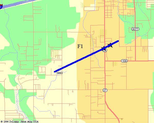
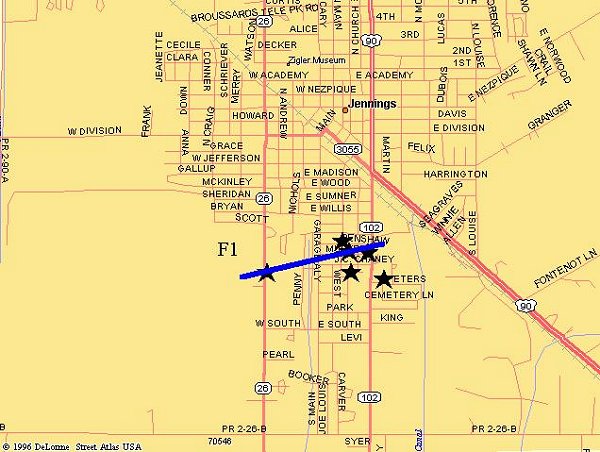
Jennings Tornado |
||
 |
||
| DATE: 1/2/99 | RATING: F1 | FATALITIES: 0 |
| TIME: 300 AM | PATH LENGTH: 1 miles | INJURIES: 0 |
| PARISH: Jefferson Davis | PATH WIDTH: 50 yards | TORNADO WARNING: 238 AM |
| STATE: Louisiana | DAMAGE: $100,000 | LEAD TIME: 22 minutes |
|
DESCRIPTION: A small tornado touched down in southern sections of Jennings, ripping a portion of a roof off a home and destroying a garage. Tops of the trees nearby were sheared off. Five other homes and several mobile homes reported minor damage. |
||
|
|
|
|
|
|
|
|
|
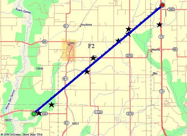
Iota Tornado |
|||
 |
|||
| DATE: 1/2/99 | RATING: F2 | ||
| TIME: 310 AM | PATH LENGTH: 10 miles | ||
| PARISH: Acadia | PATH WIDTH: 400 yards | ||
| STATE: Louisiana | DAMAGE: $500,000 | ||
| TORNADO WARNING: 304 AM | FATALITIES: 0 | ||
| LEAD TIME: 6 minutes | INJURIES: 0 | ||
|
DESCRIPTION: The Iota tornado touched down east of Evangeline in Acadia Parish and tracked northeast, just south of Iota, before dissipating near the Richard community. The most extensive damage occurred near the Richard community, where one house was nearly destroyed and another 6 received minor damage. A small airplane parked on the ground east of Iota was picked up and moved 100 yards. At least 20 homes and businesses received some form of damage along this path. Numerous power poles were knocked down along the tornado path. |
|||
|
|
|
|
|
|
|
|
|
|
|
|
|
|
|
|
Leonville Tornado |
||
| DATE: 1/2/99 | RATING: F1 | FATALITIES: 0 |
| TIME: 400 AM | PATH LENGTH: 1 miles | INJURIES: 0 |
| PARISH: St. Landry | PATH WIDTH: 50 yards | TORNADO WARNING: 345 AM |
| STATE: Louisiana | DAMAGE: $100,000 | LEAD TIME: 15 minutes |
|
DESCRIPTION: A small tornado touched down in Leonville, damaging several homes and businesses. Frozen chickens from a freezer were reported to be picked up by the tornado and deposited a quarter of a mile away in a neighbors front yard. |
||
|
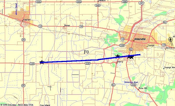
Perry Tornado |
||
 |
||
| DATE: 1/2/99 | RATING: F0 | FATALITIES: 0 |
| TIME: 432 AM | PATH LENGTH: 2 miles | INJURIES: 0 |
| PARISH: Vermilion | PATH WIDTH: 200 yards | TORNADO WARNING: 429 AM |
| STATE: Louisiana | DAMAGE: $50,000 | LEAD TIME: 3 minutes |
|
DESCRIPTION: This tornado originated near the Highway 35/335 intersection, and moved northeast. Several homes along the Vermilion River just north of Perry had minor roof damage, and one convenience store south of Abbeville had portions of its roof blown off. |
||
|
|
|
|
|
Delcambre Tornado |
||
 |
||
| DATE: 1/2/99 | RATING: F0 | |
| TIME: 442 AM | PATH LENGTH: 1 mile | |
| PARISH: Vermilion | PATH WIDTH: 100 yards | |
| STATE: Louisiana | DAMAGE: $50,000 | |
| TORNADO WARNING: 429 AM | FATALITIES: 0 | |
| LEAD TIME: 12 minutes | INJURIES: 0 | |
|
DESCRIPTION: The same storm that produced the tornado near Perry and Abbeville produced another tornado north of Delcambre. A couple of mobile homes were damaged, and several trees and power lines were downed before the tornado dissipated over Lake Peigneur. |
||
|
|
|
|
|
New Iberia Tornado |
|||
 |
|||
| DATE: 1/2/99 | RATING: F1 | ||
| TIME: 457 AM | PATH LENGTH: 4 miles | ||
| PARISH: Iberia | PATH WIDTH: 200 yards | ||
| STATE: Louisiana | DAMAGE: $1,500,000 | ||
| TORNADO WARNING: 453 AM | FATALITIES: 0 | ||
| LEAD TIME: 4 minutes | INJURIES: 0 | ||
|
DESCRIPTION: The New Iberia tornado moved east at 40 mph across northern sections of town, before dissipating southeast of the community. Over 20 homes and businesses were damaged in New Iberia, including three schools. Miraculously, no one was injured, despite one mobile home flipping over and two other homes being completely destroyed when a large oak tree crashed through them. Photos Courtesy of Lee Ball at The Daily Iberian |
|||
|
|
|
|
|
|
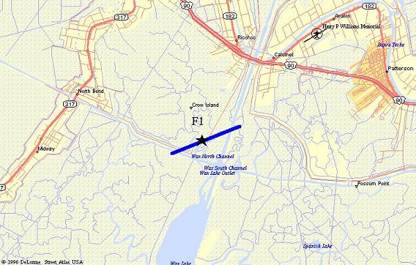
Patterson Tornado |
|
 |
|
| DATE: 1/2/99 | RATING: F1 |
| TIME: 540 AM | PATH LENGTH: 2 miles |
| PARISH: St. Mary | PATH WIDTH: 100 yards |
| STATE: Louisiana | DAMAGE: $75,000 |
| TORNADO WARNING: 520 AM | FATALITIES: 0 |
| LEAD TIME: 20 minutes | INJURIES: 1 |
|
DESCRIPTION: A tornado touched down southwest of Patterson near the Wax Lake Outlet, destroying one mobile home, several storage buildings, and removing the roof from one home. Three people were inside the mobile home at the time of the tornado, but only one person received minor injuries. According to a press release issued by the St. Mary Parish Sheriff, the tornado also destroyed some storage buildings and removed a roof from a home. |
|
|
|
|


 Follow us on YouTube