National Weather Service United States Department of Commerce

Marine banner

Observations and Forecasts

Ob for Lake Charles (south) Ob for Carlyss Ob for Abbeville Ob for New Iberia Ob for Patterson Ob for Orange Ob for Lake Charles (east) Ob for Jennings Ob for Lafayette Ob for Burns Point Ob for Nederland Ob for Beaumont Ob for Galveston Ob for buoy 42035 Ob for High Island Block 179A Ob for Sea Rim State Park Ob for Calcasieu Pass Ob for Galveston Pier 21 Ob for Galveston North Jetty Ob for Texas Point Ob for Port Arthur Ob for Sabine Pass North Ob for Sabine Pass Block 13B Ob for West Cameron Block 368A Ob for Rollover Pass Ob for East Cameron 278B Ob for Vermilion Block 331A Ob for Marsh Island Ob for Fresh Water Canal Locks Ob for South Marsh 268A Ob for Berwick Tesoro Terminal Ob for Amerada Pass Fcst for Freeport to High Island out 20-60 NM Fcst for Freeport to High Island out to 20 NM Fcst for High Island to Cameron out 20-60 NM Fcst for High Island to Cameron out to 20 NM Fcst for Cameron to Intracoastal City out 20-60 NM Fcst for Cameron to Intracoastal City out to 20 NM Fcst for Intracoastal City to Atchafalaya out 20-60 NM Fcst for Intracoastal City to Atchafalaya out 20 NM Fcst for Atchafalaya to Port Fourchon out 20-60 NM Fcst for Atchafalaya to Port Fourchon out 20 NM Fcst for Galveston Bay Fcst for Sabine Lake Fcst for Calcasieu Lake Fcst for Vermilion BayClick to get an observation or forecast!

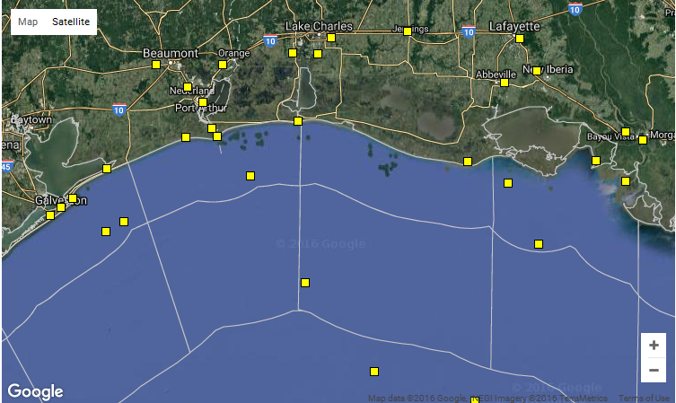
Clicking anywhere on the map above will give you the forecast for that location. Keep in mind that forecasts are generally produced for the waters from the coast out to 20 nautical miles, from 20 nautical miles to 60 miles, and beyond 60 nautical miles. 

Clicking on a yellow box will give you the latest data from that particular NCDC buoy or surface station.
 

Latest Observations
Land Stations Marine Stations
Lake Charles - south Lake Charles - east Galveston Bay North Jetty High Island Block 179A
Carlyss Jennings Buoy 42035 Sea Rim State Park
Abbeville Lafayette Texas Point Sabine Pass North
New Iberia Burns Point Port Arthur Sabine Pass Block 13B
Patterson Nederland Calcasieu Pass Fresh Water Canal Locks
Orange Beaumont Marsh Island South Marsh Block 268A
  Galveston Amerada Pass Berwick Tesoro Terminal
    Galveston Pier 21 Rollover Pass
    West Cameron Block 368A East Cameron Block 278B
    Vermilion Block 331A  


Text forecasts issued by NWS Lake Charles Text forecasts issued by neighboring NWS offices
Sabine Lake Galveston Bay
Calcasieu Lake High Island, TX to Freeport, TX out to 20 NM
Vermilion Bay High Island, TX to Freeport, TX 20 to 60 NM
Cameron, LA to High Island, TX out to 20 NM Port Fourchon, LA to Lower Atchafalaya River, LA out to 20 NM
Cameron, LA to High Island, TX 20 to 60 NM Port Fourchon, LA to Lower Atchafalaya River, LA 20 to 60 NM
Intracoastal City, LA to Cameron, LA out to 20 NM Full Coastal Waters Forecast from NWS Houston/Galveston
Intracoastal City, LA to Cameron, LA 20 to 60 NM Full Coastal Waters Forecast from NWS New Orleans
Lower Atchafalaya River, LA to Intracoastal City, LA* to 20 NM Western Gulf of Mexico beyond 60 NM
Lower Atchafalaya River, LA to Intracoastal City, TX 20 to 60 NM Middle Gulf of Mexico beyond 60 NM
Full Coastal Waters Forecast from NWS Lake Charles Other West Gulf Marine Forecasts from the NWS
* includes Atchafalaya Bay  


Other Helpful Information
 
PORTS® Data
Lake Charles Sabine/Neches
Houston/Galveston Bay Lower Mississippi River
 
Regional Radar Data
Lake Charles Houston/Galveston New Orleans
 
Marine MOS Products
West Gulf GFS Marine MOS Guidance GFS Text Messages (by Station List)
West Gulf NAM (Eta) Marine MOS Guidance NAM (Eta) Text Messages (by Station List)
Marine MOS Description Marine MOS Buoy Station Table
 
NWPS/Swan Wave Model Data Satellite Imagery Local Tide Data